Is 5G simply another generation of mobile communications technologies? Or is it something revolutionary?
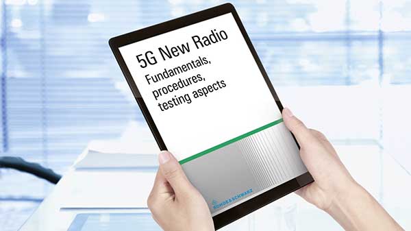
To help with answers, test and measurement specialist Rohde & Schwarz has compiled an in-depth book describing the main aspects of 5G New Radio (NR) technology. The contents of the book can be read online for free.
Rohde & Schwarz has been an active participant in the 3GPP standardization process involving cellular technologies, including the upcoming 5G NR. Five technology experts at Rohde & Schwarz wrote the book to provide in-depth information for professionals working with 5G NR technology.
The 400-page 5G New Radio: Fundamentals, Procedures, Testing Aspects provides insights into fundamentals and procedures on the architecture and transmission of 5G NR technology. The chapters provide answers to how
and why the 5G technology was specified a certain way by 3GPP. The book also discusses the new challenges to test and measurement, brought about the arrival of 5G technology, and presents modern, innovative test solutions to solve these challenges.
A roundup of recent products in the GNSS and inertial positioning industry from the March 2019 issue of GPS World magazine.
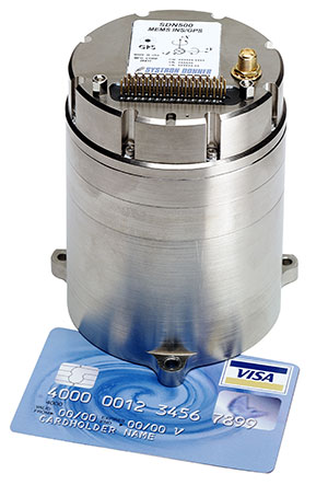
MEMS INS/GPS
Update improves heading performance and reduces jitter
Photo: Systron Donner
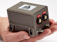
The SDN500 digital quartz micro-electro-mechanical systems (MEMS) GPS inertial navigation system (GPS/INS) has been updated. Model SDN500-xE provides a newer generation JF2 (C/A) code GPS receiver and tightly couples the 1 PPS GPS signal to the SDI505 IMU synch pulse to improve heading performance and reduce jitter after long periods of operation without dynamic inputs. The 25-inch-square SDN500 provides for maximum packaging flexibility in dense systems and delivers accuracies to within 1.0 mrad in attitude, 0.1 m/s in velocity and 3.9 meters spherical error probability (SEP). It offers tactical-grade performance, integrating SDI’s latest quartz gyros capable of 0.5°/hr. bias in-run stability and low angular random walk (ARW, 0.02°/√ hr), quartz accelerometers delivering 0.5 milli-g in-run bias stability and low velocity random walk (VRW, 80 µg/√ Hz), plus high-speed digital signal into a tightly coupled GPS/INS for tactical navigation and geo-location applications.
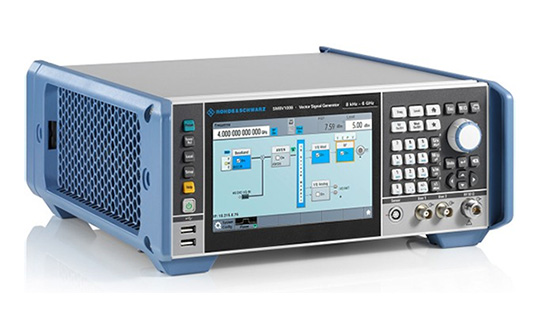
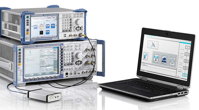
Testing location accuracy performance of mobile devices
Photo: Rohde & Schwarz
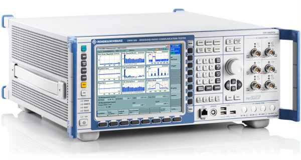
To create test concepts for over-the-air (OTA) antenna measurements, Rohde & Schwarz and Bluetest have integrated the R&S LBS Server, a software component running on the R&S CMW500 wideband radio communication tester, and the Bluetest over-the-air (OTA) test solution for A-GNSS systems based on Bluetest’s RTS65 reverberation chamber and Bluetest’s Flow measurement software. The R&S LBS Server controls the Rohde & Schwarz base-station simulator R&S CMW500 for LTE, WCDMA and GSM, and uses the R&S SMBV100B vector signal generator for simulation of GNSS and metropolitan beacon systems (MBS) signals. An upgrade for 5G will be available soon. The R&S LBS Server is an essential part of the R&S TS8991 OTA Performance Test System.
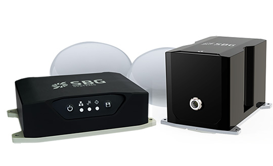
Brings Navsight technology to the most demanding environments
Photo: SBG Systems
The Horizon IMU adds a third choice to SBG System’s Navsight Land/Air Solution. It is a FOG-based high-performance inertial measurement unit (IMU) designed for highly demanding surveying applications such as high-altitude data collection or mobile mapping in dense areas such as urban canyons. The Horizon IMU joins the Ekinox and Apogee IMUs as options for Navsight. The different levels of accuracy enable the solution to meet various application requirements and can be connected to various external equipment such as odometer, lidar and more. The Horizon IMU allows customers to use Navsight in high-altitude and highly dense areas, as well as where only a single antenna can be used. It is based on closed-loop FOG technology that enables ultra-low bias and noise levels. The Navsight solution can be installed in a plane or car — the sensor alignment and lever arms are automatically estimated and validated. The Navsight unit also integrates LED indicators for satellite availability, real-time kinematic (RTK) corrections and power. Qinertia post-processing software provides access to offline RTK corrections from more than 7,000 base stations in 164 countries.
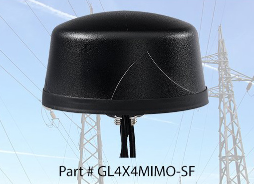
The Coach 4×4 Wi-Fi/DSRC GNSS multi-band antenna enables smart grids, mobile workforce communications, and advanced automation technologies. The dual-band 802.11ac/p MIMO antenna helps boost data rates and reliability for utility networks, intelligent transportation systems and other industrial internet of things (IoT) applications. The low-profile antenna features four-port 2.4/5-GHz coverage along with PCTEL’s high-rejection GPS/GLONASS technology for network timing and tracking in a single IP67-rated housing.
Rohde & Schwarz has expanded the capabilities of its R&S SMBV100A/B GNSS simulator and R&S CMW500 LTE network simulator to operate with Vector CANoe .Car2x, a software tool for simulation, development and test of V2X-based communication applications.
Image: Rohde & Schwarz
The solution enables engineers to easily verify critical end-to-end safety-related V2X scenarios in a lab environment. It uses the C-V2X software package for the R&S CMW500 to simulate the physical- and MAC-layer, transmitting and receiving data over the simulated PC5 interface. This covers ideal, faded and congested channel conditions to the device under test (DUT). In its current form, the solution supports both GNSS and PSSS/SSSS sidelink synchronization options.
Rohde & Schwarz and Vector have successfully demonstrated its solution, which is designed to configure and run traffic scenarios to comprehensively test the physical layer 3GPP Rel. 14 up to the application layer of C-V2X ECUs in a lab environment.
Rohde & Schwarz is demonstrating the test solution at Mobile World Congress 2019 in Barcelona in hall 6, booth 6C40, Feb. 25-28.
The automotive industry is evolving toward connected and autonomous vehicles that offer many benefits, such as improved safety, less traffic congestion, reduced environmental impact, and lower capital expenditure. With the trend to equip vehicles with 3GPP Release 14 C-V2X ECUs, peer-to-peer data transfer in ad-hoc networks between vehicles will be realized. All vehicles share location, speed and trajectory, enabling warnings regarding on-road dangers to be shared between drivers.
Applications cover use cases such as vehicle-to-vehicle (V2V) communication, data exchange with roadway infrastructure (V2I), and interaction with vulnerable road users such as pedestrians (V2P). Data communication is implemented in the 5.8 GHz and 5.9 GHz intelligent transportation system (ITS) spectrum bands.
Traffic scenarios
CANoe .Car2x offers a range of functions designed to configure and run traffic scenarios. This allows the stimulation of a C-V2X control unit according to a defined traffic situation that tests the implemented application in a structured manner.
The included Car2x Scenario Editor supports the creation of traffic scenarios using a graphical interface. CANoe .Car2x generates the corresponding ITS communication based on the test scenario. The scenario is then played back with the R&S CMW500 providing the radio access layer with the specific physical interface. This verifies data transmission and reception over the PC5 interface so that the functions of the ECU can be tested comprehensively.
The combined solution covers all layers – the complete stack, 3GPP Radio Access Layers for C-V2X Mode 4, region specific ITS protocol layers such as EU ITS-G5 and U.S. WAVE and the ITS application message sets.
This enables testing of specific use cases such as Emergency Electronic Brake Light (EEBL), Left-Turn Assist (LTA) or Intersection Movement Assist (IMA), as well as more complex scenarios with multiple simulated vehicles such as a congested highway.
Additionally, security mechanisms could also be verified running simulations with both valid and invalid signed certificates. On top of this CANoe supports all common automotive bus connectivity such as CAN, LIN, MOST, FlexRay and Automotive Ethernet, enabling the test engineer to analyze or stimulate the ECU within an entire system from their desk.
By extending the solution with the VN4610 interface from Vector, customers can access IEEE 802.11p and CAN (FD) networks as well. This enables users to analyze and test C-V2X and IEEE 802.11p (DSRC) communication and related applications with a single setup and a common user interface.
“C-V2X device testing through the application layer is a significant step towards achieving the goal of having fully connected vehicles to improve road safety,” said Anton Messmer, vice president of Mobile Radio Testers at Rohde & Schwarz. “Our efforts in developing and verifying C-V2X end-to-end application scenarios are enabling user equipment manufacturers and OEMs to reduce the time needed to roll out C-V2X technology on a worldwide basis.”
“CANoe .Car2x has a strong focus on testing V2X based protocols and ADAS applications. This combined solution, CANoe .Car2x with the R&S CMW500, enables our customers to stimulate the V2X ECU with real scenario data in order to perform tests from physical layer up to the application,” said Stefan Krauß, director of Tools for Network and Distribution Systems at Vector. “The collaboration on this solution shows what can be achieved when leading players from the automotive and telecommunication industries work hand in hand.”
Testing the antenna performance of GNSS signals such as GPS, GLONASS, Beidou, Galileo and Metropolitan Beacon Systems (MBS) is key to location accuracy performance of a mobile device.
To address the testing need for A-GNSS services, Rohde & Schwarz and Bluetest are partnering in creating test concepts for over-the-air (OTA) antenna measurements.
The CMW500 wideband radio communication tester. (Photo: Rohde & Schwarz)
The two companies integrate the R&S LBS Server, a software component running on the R&S CMW500 wideband radio communication tester, and the Bluetest OTA test solution for A-GNSS systems based on Bluetest’s RTS65 reverberation chamber and Bluetest’s Flow measurement software.
In the test setup, the R&S LBS Server controls the Rohde & Schwarz base-station simulator R&S CMW500 for LTE, WCDMA and GSM, and uses the R&S SMBV100B vector signal generator for simulation of GNSS and MBS signals.
A simple and straightforward upgrade of the setup for 5G will be available soon, making sure that investments are protected and most relevant standards can be tested with the same system.
The R&S LBS Server is an essential part of the R&S TS8991 OTA Performance Test System. This cooperation between Rohde & Schwarz and Bluetest marks the first time that the R&S LBS Server, used here as a software tool on R&S CMW500, is available also for third parties.
“We are delighted to collaborate with Bluetest to contribute with our test and measurement expertise to OTA 4G/3G/GSM and GNSS technology development,” said Alexander Pabst, vice president, Systems and Projects at Rohde & Schwarz. “With a strong global footprint for location based services LBS and close cooperation with partners, Rohde & Schwarz is committed to accompanying the evolution path from OTA testing for GPS, GLONASS, BeiDou and Galileo with innovative test and measurement solutions.”
“The addition of A-GNSS measurements means that the full range of wireless technology in a modern cellular device can be verified with just one test solution,” said Robert Rehammar, Bluetest CTO. “Bluetest has enjoyed the close cooperation with Rohde & Schwarz on this project, leading to a very strong joint solution and customer offering.”
Rohde & Schwarz and Huawei have successfully conducted cellular-based 5G V2X latency measurements in vehicular environments in field tests in Munich and Shanghai.
In a joint project between Huawei and Rohde & Schwarz, a precision end-to-end delay measurement system for over-the-air IP transmissions was applied to 5G V2X communication for cooperative driving applications in field tests in a moving car.
The precision absolute time standards on both ends were derived from two independent GPS receivers.
URLLC will enable automated driving. (Image: Rohde & Schwarz)
The initial measurements show that it is possible to achieve delays in the millisecond regime in a 5G network, demonstrating superior latency performance in comparison to LTE.
One of the key use cases of 5G is ultra-reliable low-latency communication (URLLC). Important for advanced vehicle-to-X communication use cases, URLLC will enable automated driving in the future.
A measurement accuracy below 2 µs for each transmitted IP packet was demonstrated. The transmitted data contained various IP traffic streams including video, lidar and control data (ITS messages) for a tele-operated vehicle.
While the trial in Munich was related to a tele-operated driving project, the tests in Shanghai were related to a platoon V2X testing site, where a number of vehicles traveling together are electronically connected via wireless communication.
The delay for transmission of one IP packet from source over-the-air to a (moving) receiver (sink) needs to be measured, spanning all delays introduced by the radio transmitter, propagation delay and radio receiver from/to IP packet level.
As latency is one of the key performance indicators of 5G and crucial for safety applications, such measurements could become an important criterion for future certification testing.
“We are delighted to collaborate with Huawei to contribute with our test and measurement expertise to 5G technology development,” said Andreas Pauly, executive vice president, Test & Measurement at Rohde & Schwarz. “With a strong global footprint in the telco ecosystem and close cooperation with partners, Rohde & Schwarz is committed to further expanding our innovative test and measurement solutions to new automotive applications.”
Rohde & Schwarz’s Navigation and Guidance Solutions Learning Center offers brochures, articles, technical documents, videos and posters. (Image: Rohde & Schwarz)
Rohde & Schwarz has updated its Navigation and Guidance Solutions Learning Center with several features, including application notes, white papers, training videos and products for aerospace and defense applications.
Rohde & Schwarz provides accurate, flexible, high-performance test solutions to cover every need — from design, development, calibration and production to operational maintenance for ground based systems and advanced hybrid constellation simulations for GNSS systems, the company said.
The navigation learning center now includes the latest Rohde & Schwarz solutions for GNSS testing and avionics testing. It highlights the latest company products, including aeronautical radio navigation measurement solutions, vector signal generators and GNSS signal simulators. It also provides users with brochures, articles, technical documents, videos and posters.
The navigation center is organized under three main categories: radar and electronic warfare test, satellite communication systems, and navigation and guidance.
Rohde & Schwarz’s Paul Denisowski offers an overview on the company’s EVSG1000 VHF/UHF Airnav/Com Analyzer at ION GNSS+ 2018 in Miami. According to the company, the EVSG1000 is a portable signal level and modulation analyzer specifically designed for commissioning and servicing ILS, VOR and marker beacon ground stations and for analyzing ATC COM signals.
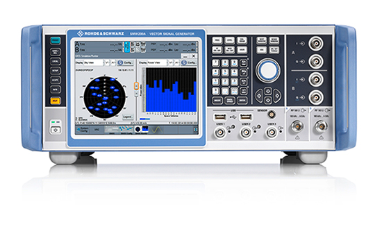
Rohde & Schwarz’s Paul Denisowski discusses the company’s latest GNSS simulator, which is based on its SMW200A Vector Signal Generator, at ION GNSS+ 2018 in Miami. According to the company, the SMW200A has an optional integrated fading simulator with up to 160 MHz bandwidth, as well as options for all important digital communications standards.
Rohde & Schwarz’s Stefan Maier gives GPS World an overview of the company’s progress on its E911 location-based services test system at ION GNSS+ 2018 in Miami.
Rohde & Schwarz has added GPS L5 and Galileo E5 simulation capabilities to its R&S SMW200A GNSS simulator.
The R&S SMW200A GNSS simulator is designed for efficient test and characterization of multi-constellation and multi-frequency GNSS receivers. With its additional simulation capabilities for GPS L5 and Galileo E5, the R&S SMW200A enables generation of complex and highly realistic test scenarios with up to 144 channels in the GNSS frequency bands L1, L2 and L5, the company said.
In addition to GPS (L1/L2/L5), GLONASS (L1/L2), Galileo (E1/E5) and BeiDou (L1/L2), the R&S SMW200A also supports signal generation for QZSS and SBAS on L1. The available channels can be routed to up to four RF outputs, so that even multi-antenna systems can be tested.
Apart from its new GNSS simulation capabilities, the R&S SMW200A can generate complex coexistence and interference scenarios with multiple interferers. GNSS signals, noise and all interference signals are generated directly in the instrument. Additional signal sources for external generation of interference signals are not required, resulting in small, compact and simple test setups.
Launched in 2017, the R&S SMW200A can be turned into a high-end GNSS simulator and is able to internally simulate complex interference environments in parallel with GNSS signals.
An increasing number of GNSS receivers are capable of receiving signals on multiple different frequencies, such as L1, L2 and L5. Although this multi-frequency capability, as well as having to process signals from diverse navigation systems such as GPS, GLONASS, Galileo or BeiDou, make the receiver design more complex, they ensure a better quality of service for the end user.
According to the company, multi-frequency and multi-constellation processing not only improves positioning accuracy, service availability and robustness, it also makes the positioning process less vulnerable to interference, jamming or spoofing attacks.
The R&S SMW200A with its new GNSS simulation capabilities will be showcased at the ION GNSS+ 2018 trade show in Miami.
A roundup of recent products in the GNSS and inertial positioning industry from the September 2018 issue of GPS World magazine.
OEM
Reference receiver
For real-time networks (RTN)
Photo: Trimble
The Trimble Alloy GNSS reference receiver is designed for continuously operating reference stations (CORS). It offers 672 channels and constellation tracking of GPS, GLONASS, BeiDou, Galileo, QZSS, IRNSS and SBAS for robust and reliable reference data. With an IP68 rating for protection against dust and moisture, the Alloy performs in rugged environments to meet the demands of professionals in earth science, surveying, construction, mapping and agriculture. The Alloy allows RTN owners and operators to track and log all current and planned GNSS and deliver absolute position monitoring, as well as centimeter-level accuracy in real time with Trimble RTX precise point positioning technology. Featuring a four-line OLED screen, the receiver displays key information without the need to scroll through multiple menus. Other features include dual hot-swappable batteries, multiple power inputs and serial ports, Wi-Fi connectivity and remote access options.
The TW7875 magnetic-mount GNSS antenna is designed for precision dual-frequency positioning. It is capable of receiving GPS L1/L5, GLONASS G1, BeiDou B1, Galileo E1/E5a and NavIC L5. It employs Tallysman’s Accutenna technology, which provides superior multipath signal rejection due to its low axial ratio across the full bandwidth. It also provides a linear phase response and tight phase-center variation. It is designed for precision agriculture, autonomous vehicles and other precision applications. The TW7875 is housed in a magnetic-mount IP67-rated housing, but can also be mounted with screws or adhesive tape. The embedded version, Model TW3875, has a wide selection of connectors and custom cable lengths, and can be custom tuned by Tallysman to ensure optimum performance within the customer’s enclosure.
The SPAN CPT7 provides tightly coupled GNSS+INS navigation technology in a rugged, compact unit. Commercially exportable and designed for integration into a wide variety of applications, it delivers assured positioning anywhere. SPAN technology tightly couples GNSS and inertial navigation system (INS) measurements. The system enables continuous, robust positioning and fast reacquisition in challenging navigation environments where GNSS signals may be unreliable or unavailable for short periods. Dual antennas deliver instant alignment. NovAtel’s OEM7 Interference Toolkit (ITK) provides interference detection and mitigation, with the spectrum analysis function allowing integrators to identify interference within the GNSS frequency bands and implement digital filters to eliminate the problem.
The commercial-off-the-shelf (COTS) LN-200C is a compact and lightweight six-degrees-of-freedom inertial measurement unit (IMU) that can be used for instrument stabilization, motion compensation and navigation in commercial, aerospace and industrial applications. Based on fiber-optic gyro (FOG) technology, the LN-200C IMU’s hermetic seal and lack of moving parts help to ensure low noise and extended operational life. The LN-200C can serve as a drop-in replacement for applications that don’t require the full operational range of the original LN-200 and that can benefit from the expedited licensing and global ease of use offered by the LN-200C.
Global Certification Forum (GCF) protocol conformance tests available
Photo: Rohde & Schwarz
The Rohde & Schwarz CMW500 wideband radio communication tester and SMBV100A GNSS simulator have been expanded to support Global Certification Forum (GCF) protocol conformance tests for C-V2X device certification. Utilizing the Qualcomm 9150 C-V2X chipset from Qualcomm Technologies, the R&S CMW500 acting as an LTE network simulator allows automakers to test C-V2X direct communications (PC5) according to GCF Work Item 281. The new R&S CMW-KK550 test package includes the 3GPP Protocol Conformance tests from LTE-V2V GCF Work Item 281 and LTE-V2X GCF Work Item 282. The R&S CMW-KU514 C-V2X software package on the R&S CMW500 is used to verify data transmission and reception over the PC5 interface in ideal, faded and congested channel conditions. Together, both packages enable Rohde & Schwarz to support C-V2X device testing through all protocol layers.
The Multimax FV family is available in a range of configurations, supporting multi-constellation GNSS. The antennas also support up to dual MIMO LTE (including Band 14 for the FirstNet public safety network), 3×3 MIMO Wi-Fi or 2×2 MIMO Wi-Fi. With a small footprint and a strong, bolt-mount aluminum base, the Multimax FV family provides protection against natural hazards threatening vehicles, including vibration, ice, salt, car washes and tree sweeps. The high-gain antennas deliver a large cellular footprint alongside high-rejection GNSS technology (GPS, GLONASS, Galileo and BeiDou).
For Beyond Visual Line-of-Sight (BVLOS) flight operations
Arctic UAV has adopted Kongsberg Geospatial’s IRIS UAS Airspace Awareness application for BVLOS operations within Canada’s Arctic. IRIS provides simultaneous monitoring of multiple drones. It offers real-time calculation of aircraft separation and communications line-of-sight, real-time visualization of track and weather data.
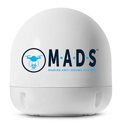
M.A.D.S detects and identifies commercial drones within a 5+ kilometer range, providing GPS positioning of both drone and pilot together with the drone’s speed and heading. Once a drone threat is established, the system enables a 500-meter electronic exclusion zone to be created around the yacht. Should the drone approach this exclusion zone, its control/video signal is blocked, initiating a fail-safe mode and forcing a landing or return to operator.
Operates on the Wave Relay mobile ad hoc network (MANET)
The Auto-Tracking Antenna System is a portable ground-to-air antenna for tracking aircraft, including drones. Defense customers can use it for better airborne communications relay and full-motion video camera/sensor data transmission. It can be assembled and deployed in less than 15 minutes.
Version 6 of Virtual Surveyor drone surveying software offers a faster, more efficient workflow and better user experience in a more stable platform than previous versions. Along with new capabilities is an improved licensing system and an extended free application. The software generates an interactive onscreen environment through orthophotos and digital surface models generated from a UAV, where the surveyor selects survey points and breaklines to define the topography. It enables land surveyors to complement traditional fieldwork with UAV imagery to generate highly accurate topographic products.
Foresights is a risk management and geospatial analytics platform designed to help clients manage forestry assets quickly, effectively and accurately. Foresights identifies areas of new or potential risk, and delivers operations tracking and forest damage management services. It combines satellite imagery, topography maps, soil maps, meteorological data and near real-time ground input from operational teams to deliver optimized insights. It can detect damage as small as 0.1 hectare (0.25 acre) from pests, disease and drought.
EOS Platform provides a powerful toolset for geospatial analysts — offering search, analysis, storing and visualization of large amounts of geospatial data. Image data obtained from LandViewer or uploaded from a user’s computer is stored in cloud-based EOS Storage and is instantly available for remote-sensing analysis or image processing. EOS Processing offers 16 workflows that run online, including raster tools, remote sensing analytics, photogrammetry and proprietary feature extraction algorithms designed by EOS engineers and data scientists to address the main challenges of agriculture, forestry, oil, gas, retail, city planning, defense and other industries.
The Esri book GIS for Surface Water: Using the National Hydrography Dataset by Jeff Simley details how to use geographic information system (GIS) technology to visualize and analyze data sets. Simley is an award-winning cartographer and the former lead of the hydrography program at the United States Geological Survey (USGS). The book examines the complexities of surface water systems and shows readers how to use the Esri ArcGIS software with government water data sets to better study and manage the United States’ vast water system.
EOMAP has opened a commercial online store for global shallow-water bathymetry derived from satellite data. At the store, EOStore Bathymetry, customers can search for and request high-quality data. Satellite-derived bathymetry (SDB) is a valuable tool for the surveying, planning and management of coastal and offshore sites. SDB can provide shallow-water bathymetric data worldwide without the need for a physical presence in the area of interest. EOMAP developed the bathymetry store in response to industry feedback. EOStore Bathymetry offers different horizontal spatial resolutions of the bathymetric grid of 2 to 15 meters, making the data suitable for surveying as well as planning and modeling purposes.
Rohde & Schwarz has expanded the capabilities of its R&S CMW500 wideband radio communication tester and R&S SMBV100A GNSS simulator to support Global Certification Forum (GCF) protocol conformance tests for C-V2X device certification.
Utilizing the Qualcomm 9150 C-V2X chipset solution from Qualcomm Technologies Inc., a subsidiary of Qualcomm Incorporated, the R&S CMW500 acting as LTE network simulator now allows automakers to test C-V2X direct communications (PC5) according to GCF Work Item 281.
3GPP Release 14 specifies the direct communications specifications for C-V2X PC5, which enables vehicle-to-vehicle (V2V), vehicle-to-pedestrian (V2P) and vehicle-to-infrastructure (V2I) safety applications, and does so without a mobile cellular subscription or network assistance and operates in ITS bands 46D (5.8 GHz) and 47 (5.9 GHz).
The new R&S CMW-KK550 test package includes the 3GPP Protocol Conformance tests from LTE-V2V GCF Work Item 281 and LTE-V2X GCF Work Item 282. As recently announced, the R&S CMW-KU514 C-V2X software package on the R&S CMW500 is used to verify data transmission and reception over the PC5 interface in ideal, faded and congested channel conditions. Together, both packages enable Rohde & Schwarz to support C-V2X device testing through all protocol layers.
C-V2X device testing is a significant step towards achieving the goal of having fully connected and autonomous vehicles to improve public safety and increase traffic efficiency.
C-V2X, including direct communications for safety applications, nicely and synergistically complements network-based communications that deliver telematics services and various use cases for connected infotainment and over-the-air software updates.
“C-V2X PC5 radio technology has quickly advanced to a pre-commercial stage, and Rohde & Schwarz is pleased to be the first test equipment vendor to offer a comprehensive C-V2X test suite,” said Anton Messmer, vice president of mobile radio testers at Rohde & Schwarz. “The automobile industry can now verify functionality and performance of C-V2X devices, as well as start device testing as per 3GPP protocol conformance tests.”
“This expanded capability complements our support for European eCall and shows our long-standing support for automotive applications,” Messmer said. “Rohde & Schwarz is committed to providing industry-leading test platforms for C-V2X device performance testing and GCF device certification.”