Tag: RTK

  • New u-blox module aimed at lane accuracy in urban areas

    New u-blox module aimed at lane accuracy in urban areas

    The ZED-F9K module is designed to keep cars in their lanes. (Photo: u-blox)
    The ZED-F9K module is designed to keep cars in their lanes. (Photo: u-blox)

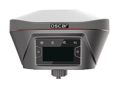
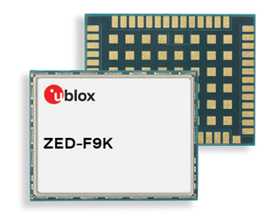
    The new u‑blox ZED-F9K GNSS and dead-reckoning module is designed to bring continuous lane accurate positioning to challenging urban environments.

    The module offers both high-precision multi-band GNSS and inertial sensors. It combines the latest generation of GNSS receiver technology, signal processing algorithms and correction services to deliver down to decimeter-level accuracy within seconds, addressing the evolving needs of advanced driver-assistance systems (ADAS) and automated driving markets.

    The ZED-F9K builds on the u‑blox F9 technology platform. Compatibility with GNSS correction services further improves positioning accuracy by compensating ionospheric and other errors.

    The real-time kinematic (RTK) receiver module receives GNSS signals from all orbiting GNSS constellations. The greater number of visible satellites improves positioning performance in partially obstructed conditions, while increased satellite signals delivers faster convergence times when signals are interrupted.

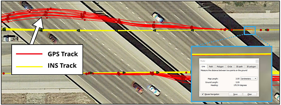
    Inertial sensors integrated into the module constantly monitor changes in the moving vehicle’s trajectory and continue to deliver lane accurate positioning when satellite signals are partially or completely obstructed, as is the case when the vehicle is in parking garages, tunnels, urban canyons or forested areas.

    When satellite signals become available again, the module combines inertial sensor data with GNSS signals to deliver fast convergence times and high availability of the decimeter-level solution.

    The result of this combination of the latest developments in GNSS technology, correction services and inertial sensing is a tenfold increase in positioning performance over standard precision solutions, according to u-blox.

    By robustly providing lane accurate position information, the ZED‑F9K meets the needs of ADAS and autonomous driving applications, as well as head units and advanced navigation systems. The module’s accuracy and low latency also makes it suitable for automotive OEMs and Tier 1 automakers developing V2X (vehicle-to-everything) communication systems. By continuously sharing their location with other traffic participants, V2X systems contribute to increasing overall road safety and reducing traffic congestion.

    “We designed the ZED-F9K to be a turnkey high-precision GNSS solution that caters to the needs of today’s and tomorrow’s connected cars,” said Alex Ngi, product manager, product strategy for dead reckoning, u‑blox. “The ZED-F9K is unique in that it integrates a multitude of technologies, from the GNSS receiver to the inertial measurement unit and relevant dead reckoning algorithms into a single device for which we can ensure performance throughout the customer product development cycle.”

    Samples will be available upon request by July.

  • Research Roundup: Design and evaluation of integrity algorithms for PPP in kinematic applications

    By Kazuma Gunning, Juan Blanch and Todd Walter, Stanford University, and Lance de Groot and Laura Norman, Hexagon Positioning Intelligence

    UAV and autonomous platforms can greatly benefit from an assured position solution with high integrity error bounds. The expected high degree of connectivity in these vehicles will allow users to receive real-time precise clock and ephemeris corrections, which enable the use of precise point positioning (PPP) techniques.

    Until now, these techniques have mostly been used to provide high accuracy, rather than focusing on high-integrity applications. The authors apply the methodology and algorithms used in aviation to determine position error bounds with high integrity (or protection levels) for a PPP position solution.

    PPP techniques can provide centimeter accuracy without local reference stations in kinematic applications. These techniques have so far mostly been used to provide high accuracy, and it is only recently that they have been proposed to provide integrity, that is, position error bounds with a very low probability of exceeding them.

    There has been preliminary work on the application of integrity to PPP, but it remains a challenge to translate the benefits of PPP to accuracy while maintaining high integrity. Most of the integrity work in PPP and real-time kinematic (RTK) has dealt more with the ambiguity resolution process under nominal error conditions and less on the integrity of the position solution under fault conditions.

    The authors overview their PPP filter implementation, and describe the threat model as well as two classes of integrity algorithms: solution separation and sum of squared residuals based (also called residual-based [RB], a misnomer, as all autonomous integrity monitors are based on the residuals.)

    They present data sets used to evaluate the algorithms, compare the protection levels (PLs) obtained with different algorithms, and present the results obtained with the most promising PL formulation in four different data sets: static, dynamic in open-sky conditions, dynamic in midtown suburban conditions, and in flight.

    Concluding, they state: “We have formulated RAIM protection-level formulas using either solution separation or the sum of residual squares. Both formulations consist of straightforward adaptations of snapshot RAIM to a Kalman filter solution.

    “For solution separation, we have shown an implementation where the computational cost of running a bank of filters is far from being proportional to the cost of one filter. Instead, we could run 50 additional filters for the cost of one.

    “For residual based RAIM we have developed a set of formulas to update the sum of square residuals from one time step to the next one. Because this test statistic is exactly the same as the one used in snapshot RAIM (when we consider the problem as a batch least squares), we could use the formula that ties the slope of a fault mode to the standard deviation of the solution separation. The slope can therefore also be updated recursively.”

    Finally, “we have refined the PPP filter, added one scenario (suburban driving conditions), and examined the effect of considering multiple faults in the formulation of the test statistics and the protection levels. The results are very promising: protection levels below 2 m appear to be achievable, and the computation load is lower than expected.”

    This paper was presented at ION-GNSS+ 2018. See www.ion.org/publications/ browse.cfm.

  • Emlid launches Reach RS2 centimeter-accurate RTK GNSS receiver

    Emlid launches Reach RS2 centimeter-accurate RTK GNSS receiver

    Emlid, the creators of Reach, centimeter-accurate RTK GNSS receiver, is now taking pre-orders for its multi-band GNSS receiver Reach RS2. The new receiver features a built-in LoRa radio, a 3.5G modem, and a survey app for iOS and Android.

    Photo: Emlid
    Photo: Emlid

    L1/L2/L5 RTK GNSS receiver with centimeter precision. Reach RS2 determines a fixed solution in seconds and provides positional accuracy down to several millimeters. The receiver tracks GPS/QZSS (L1, L2), GLONASS (L1, L2), BeiDou (B1, B2), Galileo (E1, E5) and SBAS (L1C/A), and reliably works in RTK mode on distances up to 60 kilometers and 100 kilometers in PPK mode. A multi-feed antenna with multipath rejection offers robust performance even in challenging conditions.

    RINEX raw data logs are compatible with OPUS, CSRS-PPP, AUSPOS and other PPP services so users can now get centimeter-precise results any place on Earth.

    Built-in 3.5G modem and UHF LoRa radio. The Reach RS2 features a power-efficient 3.5G HSPA modem with 2G fallback and global coverage. The corrections can be accessed or broadcast over NTRIP independently, without relying on internet connection on a smartphone.

    For remote areas, the Reach RS2 has a built-in LoRa radio that has proven to be a reliable link for RTK corrections for distances up to 8 kilometers.

    Designed for Tough Conditions. The Reach RS2 is engineered to be waterproof and impact-resistant. Its body is manufactured in a two-step injection process and is made out of shockproof polycarbonate covered in a special elastomer for extra protection. The receiver has an industry-standard 5/8-inch mounting thread.

    The LiFePO4 battery of the Reach RS2 is designed for 16 hours of work as a 3.5-G RTK rover on one charge regardless of weather conditions. It can charge from a USB wall charger or a power bank over USB-C.

    A RS232 interface allows users to connect the Reach RS2 directly to external hardware and output position in NMEA.

    Photo: Emlid
    Photo: Emlid

    ReachView App. The Reach RS2 comes with a mobile app, ReachView for iOS and Android, that is used to control all the features of the device. Users can create projects, collect and stake-out points, and import and export geodata in industry-standard formats such as CSV, DXF and Esri Shapefile.

    The Reach RS2 comes in a carrying bag with a USB-C cable and a LoRa radio antenna. The ReachView app is available for download from Play Market or App Store.

    Shipping of the first batch starts in mid-June 2019.

    See the full specs and pre-order Reach RS2 on Emlid website.

  • Maxtena launches GNSS antenna for high-precision and autonomous applications

    Maxtena launches GNSS antenna for high-precision and autonomous applications

    Maxtena Inc. has introduced a patented GNSS antenna designed for high-precision and autonomous multi-frequency applications. The M7HCT-A-SMA antenna is a high-accuracy, multi-frequency active quadrifilar helix GNSS antenna.

    Photo: Maxtena
    Photo: Maxtena

    Maxtena is a U.S.-based antenna design and manufacturing company and inventor of the patented Dynamic Aperture Technology.

    The new design will offer concurrent GNSS reception on L1: GPS, GLONASS, Galileo, Beidou and L2: GPS L2C, Galileo E5B and GLONASS L3OC in a rugged, compact and ultra lightweight form factor.

    The antenna is designed for GIS, RTK and other high-accuracy GNSS applications such as the drone and automotive markets, where high performance and low weight are driving features in antenna selection.

    The M7HCT-A-SMA active helix design features Maxtena’s patented compact and lightweight Helicore technology. This technology provides exceptional pattern control, polarization purity and high efficiency in a very compact form factor.

    The antenna offers up to 30-dB gain for GNSS applications that utilize GPS, GLONASS, Galileo and Beidou, in one radome housing with a single SMA connector.

    The M7HCT-A-SMA will join Maxtena’s line of rugged GNSS helix antennas that are ultra lightweight, small, and precise. The M7HCT-A-SMA weighs 25 grams and is housed in automotive grade PCB plastic with automotive grade electronics and is rated IP67 when mounted.

    It is ground plane independent and offers extremely low power consumption and minimal phase-center variation over azimuth. The antenna offers superb axial ratio ensuring multipath error is mitigated.

    “Maxtena is very excited to be launching a game-changing antenna for the UAV, drone, and automotive markets, and really for any application requiring a high performance, lightweight antenna that can cover so many frequencies. It is the most robust antenna solution on the market,” said Maxtena Vice President of Sales and Marketing Vanja Maric.

  • Global GNSS launches survey application

    Global GNSS launches survey application

    Image: Global GNSS
    Image: Global GNSS

    Global GNSS, a subsidiary of Polosoft Technologies, has launched a new mobile application named GNSS Surveyor, which is designed for the geospatial industry.

    The application GNSS Surveyor provides location information and quality position data in real-time with sub-meter to centimeter accuracy. It needs to be connected to any external GNSS receiver via Bluetooth.

    Features of the application include:

    • A one-touch configured command to communicate directly with the GNSS Bluetooth device.
    • Location information and quality of the position data in real-time with centimeter accuracy.
    • GPS data such as position, height, satellites and velocity.
    • Constellation information for GPS, GLONASS, Galileo, BeiDou, QZSS and SBAS satellites in the orbit.
    • Direct IP feature for RTK corrections data.
    • DMS to DD conversion or vice versa.

    Real-time kinematic (RTK) correction data can be forwarded to a high-accuracy external device. The internal NTRIP client loads the RTCM data from the internet.

    With GNSS Surveyor, location information is collected as latitude and longitude, altitude, speed or pace, bearing and UTC time.

    GNSS precision includes global coverage, centimeter-level accuracy, fast time to first fix, multi-constellation and multi-band, and highest security, the company said.

    Navigation uses include ground robotics navigation, lane-level navigation, heavy machine navigation, industrial navigation and tracking and commercial UAV.

    GNSS Surveyor can be downloaded from the app store.

  • Yuneec provides RTK on commercial hexacopter H520

    Yuneec provides RTK on commercial hexacopter H520

    Photo: Yuneec
    Photo: Yuneec

    Yuneec International’s commercial hexacopter, the H520, will now optionally be available with an RTK (real-time kinematic) system from the Swiss company Fixposition.

    Under difficult GPS conditions, such as in cities or canyons, the RTK system ensures maximum precision and centimeter-precise positioning. The fully integrated RTK satellite navigation enables extremely accurate recurring images and faster 3D mapping. It also makes automated inspection flights easier and more precise, the company said.

    The new H520 RTK is suitable for commercial applications that require maximum precision. By using RTK technology, the H520 can now fly much closer to objects for inspection as the UAV positions itself precisely in the centimeter range (1 cm + ppm horizontal / 1.5 cm + ppm vertical) rather than in the meter range, which is standard for the H520.

    This accuracy is paramount for applications where several images need to be taken at the same location on different days including:

    • documenting progress on construction sites,
    • inspecting mountain landscapes to prevent natural hazards such as rock falls or avalanches, and
    • forensic accident scene reconstruction.

    In addition, the satellite navigation system makes it possible to significantly reduce image overlaps, which means fewer photos and shorter model calculation times, maximizing efficiency in workflows.

    The RTK system is not only fully integrated into the hardware, but also into the UAV’s software. This means the user retains the full range of functions of the DataPilot software, including mission flights.

    The H520 RTK works with two components: the RTK module on board the H520 and a base station on the ground. For precise navigation, the module supports constellations of up to three different satellite systems from GPS, GLONASS, Galileo and BeiDou.

    If the use of a ground station is not possible, the system can also be operated with a national reference station network (network RTK). The network RTK is provided by third-party providers and requires an internet connection, such as a mobile hotspot. All data including satellite data is recorded, which makes the H520 RTK suitable for post-processed kinematics (PPK).

    The H520 RTK will be available in the second quarter of 2019. Technical specifications are available here.

  • Inertial Sense releases RTK-INS for consumer applications

    Inertial Sense releases RTK-INS for consumer applications

    Dime-sized INS with RTK paves the way for high accuracy in mass-market consumer applications.

    Photo: Inertial Sense
    Photo: Inertial Sense

    Inertial Sense has released a new micro-sized inertial navigation system (INS) with precise real-time-kinematic (RTK)-level accuracy. The company says the new solution paves the way for high accuracy in mass-market consumer applications.

    The new micro INS with RTK solution offers an accuracy of 2-3 centimeters using GPS positioning in combination with inertial sensors (including on-board sensor fusion).

    Inertial Sense designs and manufactures precision INS+RTK GPS sensors that deliver fast, accurate and reliable altitude, velocity and position for a wide range of autonomous vehicle applications, the company said.

    The new micro INS with RTK provides a high degree of precision for orientation and GPS in a tiny package. Standard INS/GPS sensors offer accuracy in the range of 1.5 to 2 meters. Inertial Sense’s micro INS with RTK offers accuracy of 2-3 centimeters.

    In the image above, a vehicle travels under an overpass. The 3-cm accurate RTK-inertial navigation track holds true to the vehicle’s position while the standard GPS signal is lost. (Image: Inertial Sense)
    In the image above, a vehicle travels under an overpass. The 3-cm accurate RTK-inertial navigation track holds true to the vehicle’s position while the standard GPS signal is lost. (Image: Inertial Sense)

    “The incredibly small size of our new micro INS with RTK sensor, in combination with its extremely affordable price point, will make this type of highly sophisticated technology accessible for general consumer applications for the very first time,” said Walt Johnson, founder and CTO, Inertial Sense. “We are offering RTK at a size, accuracy and price point that the market has never seen before.”

    By optimizing the manufacturing processes for high volume applications, the micro INS with RTK sensor is as small and lightweight as a dime, and is available at a low price point.

    Sensor fusion. Sensor data from MEMs gyros, accelerometers, magnetometers, barometric pressure and u-blox GPS/GNSS are fused to provide optimal position estimation. Data out includes angular rate, linear acceleration, magnetic field, barometric altitude and GPS time.

    The miniature module provides orientation, velocity and position. Base station corrections data can be applied to achieve centimeter-level precision.

    Autonomous vehicles. The sensor will enable the navigation of all types of autonomous vehicles with a very high degree of precision, Inertial Sense said.

    Inertial Sense patented modules are currently being sold worldwide at volume for a broad variety of applications including:

    • Autonomous navigation: Drones, ground robotics, precision ag, automobiles
    • Aerial surveys: UAV Payloads for 3D mapping, photogrammetry, orthomosaics
    • Gimbal stabilization and antenna pointing
    • 3D motion capture and personnel tracking

    Evaluation kits. Inertial Sense has bundled evaluation kits it says are simple to use and contain everything needed to begin logging RTK-accurate data. The evaluation boards can be utilized in both rover and base station configurations and include 900-mhz radios with onboard logging capabilities.

  • Sokkia introduces integrated receiver for diverse applications

    Sokkia introduces integrated receiver for diverse applications

    Sokkia introduced the latest addition to its GNSS integrated receiver line — the GRX3. According to the company, the GRX3 is designed to provide a smaller, lighter and fully integrated GNSS solution.

    Photo: Sokkia
    Photo: Sokkia

    “The multi-constellation GRX3 receiver is built to offer a complete and versatile solution to provide best-in-class positioning performance for a wide variety of precision applications,” said Alok Srivastava, director of product management.

    “Whether using the receiver for GNSS post-processed surveying, or RTK using wireless technologies including network RTK option with a cellular-equipped field computer, a SiteComm RTK rover, or paired with a Sokkia total station for fusion positioning, the GRX3 provides the most advanced and powerful GNSS technology available in a more compact and lightweight housing that can withstand the harshest of environmental conditions. Combine it with one of Sokkia’s data collectors and field software for maximum versatility and convenience, increasing fieldwork efficiency from start to finish.”

    The receiver features Sokkia Tilt technology, which includes a 9-axis inertial measurement unit and ultra-compact eCompass designed to compensate for mis-leveled field measurements by as much as 15 degrees.

    “The GRX3 is designed as a ‘future-proof’ solution with an advanced GNSS chipset with Universal Tracking Channels technology that automatically tracks signals from all available and planned constellations — including GPS, GLONASS, Galileo, Beidou, IRNSS, QZSS, SBAS,” Srivastava said.

    The receiver has been tested to meet IP67 certification for protection against harsh environmental weather conditions.

  • GeoCue enables third-party GNSS use with Phantom 4 RTK

    GeoCue enables third-party GNSS use with Phantom 4 RTK

    DJI Phantom 4 Pro with Loki PPK system. (Photo: GeoCue)
    DJI Phantom 4 Pro with Loki PPK system. (Photo: GeoCue)

    GeoCue Group (via its wholly owned AirGon subsidiary) has completed the integration of the DJI Phantom 4 Pro RTK (P4R) into its AirGon Sensor Processing Suite (ASPSuite).

    ASPSuite is a post-processing solution for GeoCue’s Loki direct geopositioning system for DJI and other manufacturer’s drones.

    ASPSuite enables integration of the P4R with third-party L1/L2 GNSS base stations such as systems from Septentrio, Leica, Trimble, Topcon, CHC and others in a high accuracy post-process kinematic (PPK) workflow.

    In addition to PPK processing, ASPSuite includes support for options often required in engineering-grade surveys such as:

    • vertical transforms (such as ellipsoid to country-specific geoids)
    • creation of and transformation between collection datums and local coordinate systems (site calibration)
    • application of antenna static and dynamic lever arm corrections
    • full support for Loki direct geopositioning systems.

    The DJI D-RTK-2 base station (optionally available) for the P4R can only be used in RTK mode, and then only if it is being sited on a known location. The D-RTK-2 does not currently allow access to an observation file, preventing it from being stationed using an online positioning service such as OPUS, AUSPOS, Canadian Geodetic Survey services and so forth. An additional consideration in the integration into ASPSuite is that professional surveyors already have the survey kit that they need incorporated into this workflow.

    GeoCue is offering camera calibration services for the P4R for customers who wish to do minimal or control-free high-accuracy mapping projects (the DJI “calibration” is an image de-warping algorithm, not a proper photogrammetric calibration). A test of a GeoCue-calibrated P4R using an OPUS-positioned base station and ASPSuite achieved about 4-cm horizontal and 5-cm vertical network accuracy (RMSE) with no ground control points.

  • Hemisphere highlights RTK products and solutions at Intergeo 2018

    Hemisphere GNSS’ Miles Ware discusses the company’s line of RTK positioning products and GNSS technology at Intergeo 2018, which took place Oct. 16-18 in Frankfurt, Germany. The solutions are suitable for the marine, machine control and land survey markets.

  • CHC Navigation releases all-in-one GNSS RTK solution

    CHC Navigation releases all-in-one GNSS RTK solution

    The i50 GNSS receiver comes bundled with the CHC HCE320 Android controller and CHC LandStar 7 field data collection software. (Photo: CHC Navigation)
    The i50 GNSS receiver comes bundled with the CHC HCE320 Android controller and CHC LandStar 7 field data collection software. (Photo: CHC Navigation)

    CHC Navigation has unveiled its i50 GNSS receiver, an all-in-one GNSS RTK solution.

    The GNSS receiver comes bundled with the CHC HCE320 Android controller and CHC LandStar 7 field data collection software. According to the company, it is a cost-effective solution for topographic and construction positioning tasks in land surveying, small- and medium-sized construction projects, and precision GIS data collection.

    “The i50 GNSS is designed to match the demand of cost-conscious yet demanding professionals searching for one all-in-one GNSS RTK survey solution,” said Hans Huang, product manager of GNSS solutions for CHC Navigation. “By integrating field proven GNSS positioning and communication technologies in a compact and rugged unit, land surveyors will experience unmatched work flexibility in their daily field work with CHC i50.”

  • Tersus introduces Oscar GNSS RTK system

    Tersus introduces Oscar GNSS RTK system

    Photo: Tersus GNSS
    Photo: Tersus GNSS

    Tersus GNSS Inc. has launched Tersus Oscar, its new generation GNSS real-time kinematic (RTK) system.

    Oscar is an all-in-one GNSS receiver that can be used as rover or base system. Paired with a Tersus TC20 controller or A11 mobile terminal, Oscar can more efficiently meet customer application requirements for the optimal surveying solution, according to Xiaohua Wen, founder and CEO of Tersus GNSS.

    “Last year, we launched the David GNSS receiver,” Xiaohua said. “This year, we are very excited to introduce an advanced version of David; we named it Oscar.”

    Oscar supports calibration-free tilt compensation function, meaning a leveling pole is no longer required. Configuration is made easy with a 1.3-inch interactive screen. With an internal high-performance multi-constellation and multi-frequency GNSS board, the Oscar GNSS receiver can provide high accuracy and stable signal detection, the company said.

    The high-performance antenna can speed the time to first fix and improve anti-jamming performance. The built-in large capacity battery can support up to 10 hours of fieldwork.

    A radio module in the package supports long-distance communication. With its rugged housing material, Oscar is protected from harsh environments.