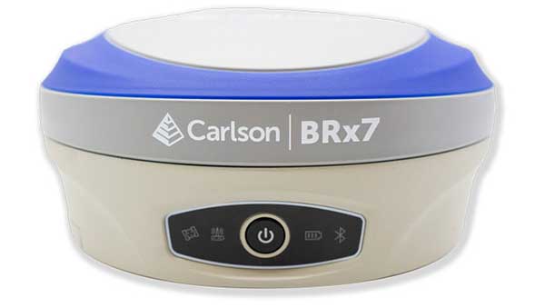
Carlson Software is now offering its next-generation multi-frequency, multi-GNSS BRx7 smart antenna.
The BRx7 is a full redesign of Carlson’s flagship GNSS receiver, delivering high-level specifications, performance and value for surveyors, contractors, engineers and GIS professionals.
Weighing 2.8 pounds with batteries, the BRx7 saves time and increases productivity by accurately compensating for tilt. It comes standard with dual, hot-swappable batteries for 11+ hours of uninterrupted efficiency. The BRx7 provides 800+ channels, 8gb of memory, and is designed with a rugged, compact IP67-rated housing.
Best-in-class RTK performance is provided by the Athena GNSS engine, supporting multi-frequency GPS, GLONASS, BeiDou, Galileo, QZSS, IRNSS and Atlas L-band capability. In addition, the BRx7 uses proprietary SureFix technology to provide a high-fidelity quality indicator of the RTK solution, allowing users an extremely high confidence in their current accuracy.
The BRx7 provides RTK baselines up to 50 km with fast acquisition times when used with Carlson Listen-Listen, as well as UHF, spread spectrum, cellular, Bluetooth and Wi-Fi wireless communication.
Well-suited to a variety of operating modes, the BRx7 can be deployed as a powerful base with additional access to BeiDou phase 3 satellites in a base-rover setup, or as a lightweight, powerful network rover.
“The BRx7 represents the next generation of GNSS technology,” said Butch Herter, Carlson’s director of hardware development. “Through this total redesign in partnership with our manufacturer, Hemisphere GNSS, we’ve brought the technology and functionality above the competition while retaining the ease-of-use, durability, and superior support that Carlson is known for.”
The smart antenna comes with a dual-band radio module that is capable of both 400 MHz and 900 MHz operation. This allows for the long range capability of the UHF 400 MHz signal plus the ability to switch to the 900 MHz frequency-hopping spread spectrum (FHSS) signal for better performance in noisy radio environments.
The BRx7 introduces a new INS-based sensor-fusion platform to support enhanced tilted pole measurements for land survey applications. This new design allows for easy calibration, is immune to magnetic interference, and is extremely reliable in virtually any environment.
“The BRx7 represents the advanced technology, durability, and ease-of-use that our customers have come to expect,” said Bruce Carlson, founder and president of Carlson Software. “By redesigning this system from the ground up, we are offering our customers both unparalleled performance and versatility, but also a value that’s unbeatable in the market today.”
Thirty years ago, more than a decade before most people had even heard of GPS, receiver manufacturers and surveyors were already improving on it by providing and using correction services to compensate for errors in the system—including clock drift, orbit errors, signal errors, atmospheric errors and multipath.
Today, dozens of public and commercial correction services enable users to achieve accuracies of decimeters, centimeters or even millimeters. Also, many GNSS processing services correct measurements taken in the field using data from reference points. Increasing positioning accuracy has become the cornerstone of modern GNSS practice.
The current boom for correction services is driven mostly by the demand for high accuracy from the automotive industry (including the development of self-driving cars), as well as smart consumer devices and various forms of automation. Automotive companies and telecoms are deploying infrastructure around the globe to provide centimeter-level positioning. GNSS satellites also can transmit corrections directly, as the Japanese CLAS service from the QZSS constellation does, and Galileo’s High-Accuracy Service (HAS) soon will. To compensate for receiver-side issues — multipath, jamming and spoofing — some GNSS receivers also incorporate advanced positioning algorithms.
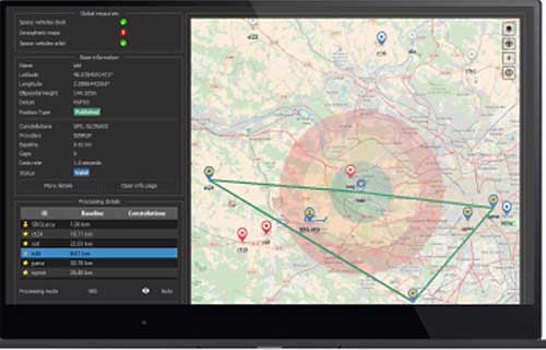
Clock and orbit errors are specific to each satellite; they do not depend on the position of the receiver. But atmospheric errors are introduced when the signal travels from the satellites to the user. Reference stations (base stations) of GNSS receivers installed at fixed and precisely surveyed positions provide corrections that compensate for both sets of errors to the rovers carried by field crews. When connected, reference receivers spread over a geographic area form reference networks, such as that of continuously operating reference stations (CORS). Achieving maximum accuracy requires initializing the receiver, which can take a few seconds to several minutes, depending on the type of corrections.
Established and new methods
Two established methods have been used for decades.
Real-time kinematic (RTK). In RTK, a receiver obtains correction data from a single base station or a local reference network in the same area.
Precise point positioning (PPP). While accessible from anywhere in the world, receiver initialization for PPP can take up to 30 minutes. Also, a few PPP correction services only provide corrections for satellite clock and orbit errors and not for atmospheric errors, limiting users to a lower accuracy level than with RTK.
Hybrid PPP-RTK. In recent years, new methods have emerged. Hybrid PPP-RTK combines near-RTK accuracy and quick initialization times with the global access of PPP. It relies on a network of reference stations within about 150 kilometers of each other. The stations collect GNSS data and calculate both satellite and atmospheric correction models. The network then broadcasts these corrections via internet, satellites or cellphone towers to subscribers, who can use them to achieve sub-decimeter accuracy.
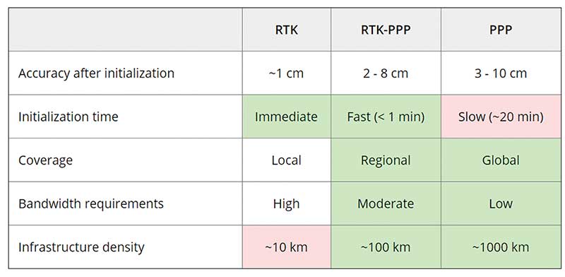
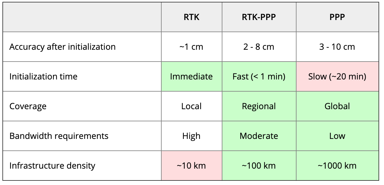
Each of these methods has advantages and disadvantages (see table 1). RTK, which relies on communication between the user and the local correction service, provides centimeter accuracy over small areas. PPP-RTK and PPP broadcast corrections and require a lighter infrastructure, making them scalable for mass-market and industrial applications. The new services are cheaper and more user-friendly than traditional correction services.
TABLE 1: Differences of various correction methods. (Chart: Septentrio)
CORS/VRS
Traditional reference networks — often called CORS or virtual reference station (VRS) networks — have long been a source of differential GPS (DGPS) and RTK corrections, mainly for surveying and mapping applications, which require high accuracies.
“Most CORS in the United States are strictly for providing high-accuracy correction data to GNSS users who need to know their position to less than an inch,” said Alex Ngu, applications engineer at Trimble. “However, some — like Utah’s TurnGPS network and the North Carolina Geodetic Survey (NCGS) — have considered dabbling in using them to double up for weather monitoring.” In some regions, such as Japan and Washington state, CORS are also used to study plate tectonics and provide early warning of earthquakes.
CORS receivers often operate in remote locations and may be powered by solar panels. Therefore, they require low power consumption and the ability to configure, run and update remotely. They also need to archive on-board measurements and withstand harsh environments.
Changes in the market
As the market for GNSS corrections changes, so does the role of CORS networks. They are increasingly used for industrial automation that needs centimeter accuracy, including construction and agriculture. “Now, due to the growth in autonomous systems, such as autonomous cars, people are looking at corrections in a completely different way and with more focus on mass markets,” said Gustavo Lopez, market access manager at Septentrio. Septentrio lets customers choose which correction service to use.
“CORS/VRS networks will keep focus on performance and on adding constellations and signals, but nothing major is expected to happen in these traditional systems,” Lopez said. They will continue to exist because they focus on centimeter-level accuracy for survey, construction, mining, machine control and precision agriculture. “What will really change the market are these new services with 10-cm to 20-cm accuracies, which also offer a new way of delivering the data, namely broadcasting rather than using two-way communication methods.” This helps with adoption by emerging applications, Lopez said.
He predicts that applications needing 10- to 50-centimeter acurcy will migrate to cheaper services, including new consumer applications, advanced driver-assistance systems (ADAS), professional applications such as robotics, UAVs, logistics and internet of things (IoT) applications.
Mobile technologies adopting dual-frequency chipsets also will need correction services. “We will see more and more telecoms interested in providing GNSS corrections as a service, as is already the case in Asia and Europe,” Lopez said. “A few CORS/VRS networks will try to capture part of this emerging applications market by reusing their technology or partnering with other companies to provide a more transparent solution.”
One might think that the rapid expansion of the market for corrections would make it possible for traditional CORS networks to make 1-cm accuracy available at a much lower price. The roadblock is high infrastructure costs, Lopez explained. CORS/VRS networks are expensive to maintain because they require a high density of stations. New services that use broadcasting technology and PPP-RTK positioning modes rely on less dense networks.
New uses for old CORS
A key benefit of a VRS is that performing RTK positioning across the area it covers does not require guarding a separate GPS base station. Using VRS, the CORS network acts essentially as a continuous reference station within the entire network, enabling RTK positioning using a single rover in the field.
Randy Osborne, VRS network manager at Louisiana State University’s Center for GeoInformatics, reports a growth in new applications beyond surveyors. VRS expanded to precision agriculture, and then into applications such as lidar and UAVs. “We are also seeing strange applications that we never thought of. For example, plumbing companies use it to navigate underground from a truck that has a position on the network, and then they vector from the truck underground into pipelines,” Osborne said. Subscribers also include companies performing survey work for fracking and petrochemical projects.
OSR vs. SSR
Most GNSS correction services are based either on the observation state representation (OSR) or on a state space representation (SSR) of the errors. OSR and SSR use different techniques, delivery mechanisms and core technologies.
OSR. Legacy GNSS correction service providers supply OSR correction services; examples are RTK and networked RTK (RTN). They rely on transferring corrected GNSS observations from the nearest reference station to the rover using a standardized format. They focus on a geographic region and target surveying, machine control and precision agriculture, providing centimeter-level accuracy up to about 30 kilometers of the nearest reference station. Because these services require bi-directional communications and large bandwidth, it is hard to ramp them up for mass-market applications.
SSR. By contrast, new players in the market for correction services, as well as some of the larger legacy ones, provide SSR correction services. SSR uses a network of reference stations to model major errors over large areas. They then transfer this model to the rovers, which create local error models and apply them to their GNSS observations. Depending on the service, accuracy ranges from less than 5 cm to 20 cm, convergence times from 10 seconds to 30 minutes, and coverage from continental to global. Because SSR corrections are broadcast, they can be more easily distributed through internet connections and L-band satellite channels. Because all the rovers rely on the same stream of GNSS correction data, SSR services work well for mass-market applications. The growth in SSR technology is driven mainly by the needs of the automotive industry but is sufficiently generic for adoption in other markets.
The challenge of vertical accuracy
A CORS receiver stands atop the Old River Auxiliary Control Structure, a floodgate system in a branch of the Mississippi in central Louisiana. (Photo: Trimble)
While OSR and SSR have comparable accuracies on a horizontal plane, they differ greatly in their vertical accuracy and initialization times, Osborne said. “When we look at CORS for active control and positioning in the National Spatial Reference System, we are mainly trying to get a handle on the vertical part, as it is the hard problem to solve,” he said.
High-precision vertical accuracy is a challenge for any GNSS-based method. Conventional surveying is still the gold standard. With differential leveling, like with digital levels, results in millimeters are possible. Post-processed GNSS, using data from a good geometry of CORS or base data, can yield results under 2 cm vertical, as can real-time OSR methods like RTK and RTN. SSR solutions, like PPP and hybrids, are presently achieving 5 cm at best. An Achilles heel for SSR vertical solutions is the lack of data for localized sources of error, like tropospheric conditions. Semi-dense networks of CORS can feed ionospheric data to speed PPP convergence, but not the level of tropospheric data needed to match the vertical results that OSR and conventional methods can.
Trimble
Trimble GNSS base-station receivers have been used for 40 years on every continent, according to the company. Today, products in use as CORS stations typically are Alloys, NetR9s and NetR5s. The company operates more than 300 networks worldwide, incorporating more than 5,000 CORS receivers.
Trimble offers a full spectrum of solutions, services and subscriptions related to CORS networks. They range from supplying CORS software, hardware and services, to providing network management services to run a secondary backup system for a network, or even operating a network on behalf of its owner. For those who just want a high-accuracy correction to support their surveying, GIS or machine guidance and control work, “Trimble operates one of the largest CORS networks in the world to which users can subscribe — Trimble VRS Now, Trimble RTX and OmniSTAR services,” Ngu said.
Feature photo:
In Long Beach, California, correction services support the 250-foot-high Gerald Desmond Bridge project. Trevor Rice (left), president of D. Woolley & Associates, joins Kimberley Holtz, director of survey, Port of Long Beach. (Photo: Trimble)
When someone imagines the Australian outback, they’re picturing Australia’s largest state, Western Australia (WA), which occupies an entire third of the continent.
Nearly all WA residents live in Perth, with the rest of WA reminiscent of the United States’ historic Wild West — sparsely populated towns with little infrastructure. That wild beauty and remoteness can also make surveying a less-than-beautiful experience.
“The outback of WA is a real test on my adaptability and logistics skills,” said Phil Richards, a professional surveyor and associate director with Perth-based RM Surveys. “It can take 1.5 days to get to your first site and once there, you’re totally isolated with no resources — and climate conditions that can range from 0 to 50 degrees Celsius. The sparse, rugged road systems make navigating anywhere a long journey. And if the weather turns bad on your job and you didn’t plan well, you could be completely stranded.”
Technological challenges that add to the complexity: limited mobile phone service, time-consuming RTK base station setups, inconsistent RTK cellular or radio communication, and geodetic control points that are difficult to access.
Advances in precise point positioning (PPP) technology, however, have been helping to resolve these obstacles and enable surveyors to optimize their real-time productivity without sacrificing accuracy. For Richards, who specializes in remote surveying work, this modern GNSS enhancement has helped bring a little tameness to the wilds of WA, enabling him to increase data collection efficiencies, reduce costs and boost the company’s bottom line.
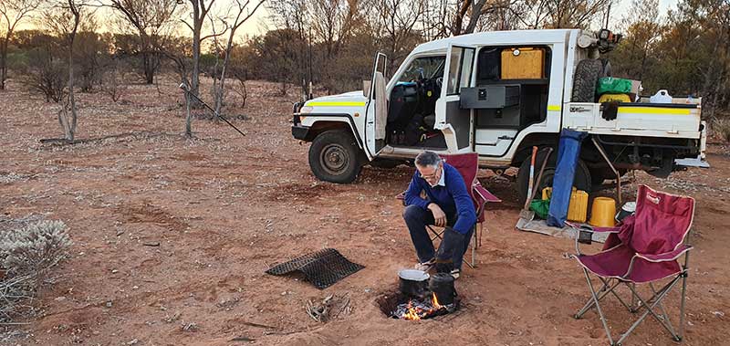
Camp breakfast: The R10 receiver rests on a spur while Phil Richards dines out. (Photo: Trimble)
The case for a new approach
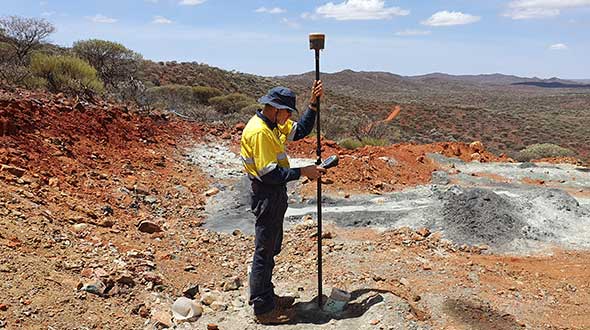
With his aptitude for remote surveying, much of Richards’ project work in WA has been in support of heavily active mining companies. For example, for the past 15 years, one iron ore producer has contracted him to travel more than 600 kilometers from Perth to measure exploratory drill hole collars. Drill collars, the remnants of drilling activity, are 3-millimeter-thick segments of PVC, about 150 mm in diameter, which protrude about 300 mm out of the ground, typically at a 60-degree angle. Measuring the center of that above-surface collar is a crucial stage in the exploration process to enable the client to develop a geological model of the mineral resource underground.
Managing 10 prospect sites across 300 km, the number of drill holes can vary from year to year, but there can be as many as 100 holes spread out over a few prospects at a time. Since 2007, Richards has been using Trimble R8 and, more recently, Trimble R10 GNSS receivers and RTK technology to acquire the drill-collar measurements.
On average, each prospect is 5 km by 2 km and has its own coordinate network. Depending on the number of collars and the distance to each, Richards would set up between two and nine RTK base stations on known control points to set project control. Using his Trimble GNSS receiver, he’d either drive or walk to each drill collar, set the foot of the range pole on the center of the collar at ground level, take a reading and record the measurement in Trimble Access field software on a Trimble TSC3 controller. Although the need for multiple base stations had added hours onto the projects, the RTK method consistently provided the needed accuracy.
X hits the spot
In 2015, the iron ore company restructured its mineral exploration program. Rather than drill numerous exploratory holes across a few prospects, the new focus was to drill fewer holes spread over the entire project area. That was going to be problematic for Richards’ traditional RTK routine.
“Previously, when it was predominantly surveying and less traveling, the RTK approach worked well for the project, even though setting up base stations is time consuming,” said Richards. “But when that switched to less surveying and more traveling, continuing with RTK was going to increase costs because each time I have to set up my base station, that’s an extra hour. If I have 10 drill-collar zones, that’s 10 hours. And if my base station is 10 minutes away, it adds more time and expense if I have a problem with it, or I can’t get a reliable signal, and I have to travel back to it to fix it or move it. The reduced number of collars and the increased distances between them required a more efficient method to make the project profitable.”
Taking the R10 off the vehicle mount. (Photo: Trimble)
Richards decided to test Trimble’s CenterPoint RTX correction service as an alternative. CenterPoint RTX is built on a network of GNSS tracking stations around the world that stream multi-frequency, multi-constellation data to the company’s network control centers. Advanced data processing algorithms analyze the three main error sources: satellite orbits, clock offsets and atmospheric effects, and develop models and correction data. This information is delivered to GNSS rovers via L-band satellite communications. The rover combines the correction data with its own satellite observations to produce accurate positions.
Richards ran five trials in conjunction with varied exploration surveys at test sites across 1,000 km of terrain. He took RTX measurements of survey control points with his R10 and compared them to the same positions acquired with RTK. Although the CenterPoint RTX can take up to 15 minutes to reach sub-2-centimeter horizontal accuracy in WA, Richards said the technology regularly delivered on performance. Most importantly, this technique enabled him to work without a base station and obtain real-time GNSS positions with centimeter accuracy even in isolated WA.
Integrating Trimble’s CenterPoint RTX into his workflows enabled Richard to use a single GNSS receiver system, much like working within the VRS networks available in the more populated areas of Australia.
Into the Outback
For the 2019 campaign, Richards and a colleague were contracted to acquire accurate 3D positions for 13 drill-collar holes stretched across two major prospects about 150 km apart. Their area of interest was 700 km northeast of Perth.
Within a 15-km-wide area, they had to acquire measurements for eight drill-collar holes. They calibrated the R10 receiver to the nearest control point to tie into the site’s coordinate system and moved through the area, methodically recording the positions of each collar hole. Despite the rough terrain, they finished both prospect sites in 1.5 days, compared to 2.5 days had they used RTK.
“Given the project format, with so much travel time and less surveying time, RTX is really the only way to do it,” Richards said. “It’s far quicker than setting up base stations — I saved 50% of the time using RTX on this campaign. I’m more efficient; I’m able to keep costs down; and I have the confidence in the system that I know I’ll deliver on accuracy. It’s hard to justify using any other method.”
Eos Tools Pro implements powerful new features that enables users to exploit all four global GNSS constellations and a state-of-the-art NTRIP client to access real-time kinematic (RTK) bases and RTK networks all over the world via NTRIP, Direct IP and wireless radios.
“This is a huge step forward in functionality and flexibility for our Windows users,” said Jean-Yves Lauture, CTO of Eos. “We implemented the latest support for Windows Geolocation and other features offered by Microsoft in order to allow our customers to use high-accuracy locations directly into their apps.”
Eos Tools Pro includes new features for both field professionals and application developers.
For field professionals
RTK network/RTK base connectivity. Eos Tools Pro implements state-of-the-art NTRIP connectivity to connect to any RTK network or RTK base in the world. For geographic areas without cellular coverage, Eos Tools Pro supports Bluetooth wireless radios (UHF/VHF, etc.) for base/rover connectivity.
The software supports all new BeiDou and Galileo satellites in addition to GPS and GLONASS as well as SafeRTK functionality for areas with marginal cellular coverage.
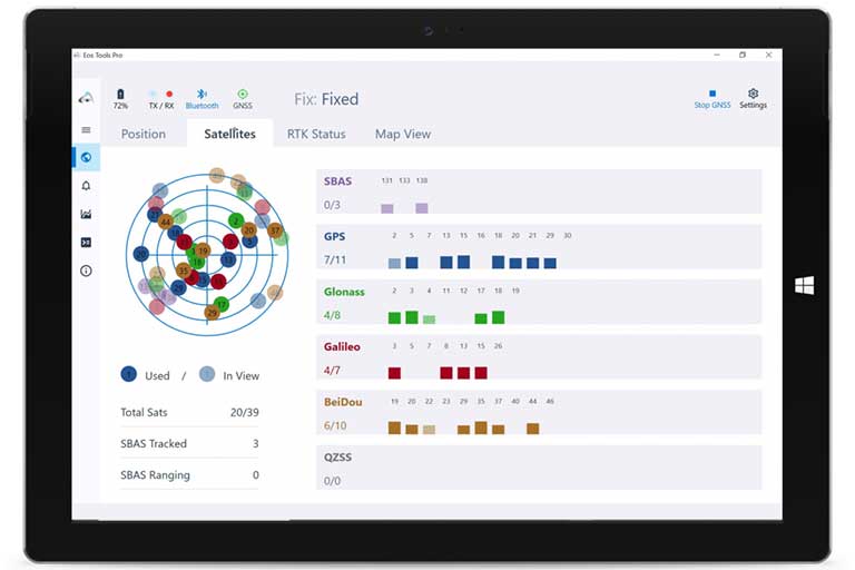
Eos Tools Pro for Windows shows all current satellites in use from GNSS constellations such as GPS, Galileo, BeiDou, GLONASS and QZSS. (Screenshot: Eos Positioning)
Geoid models. Eos Tools Pro implements the latest geoid models for many regions in the world, providing survey-grade orthometric heights directly into any Windows applications.
Datum shift. Eos Tools Pro adds a new feature to apply a simple X, Y, Z shift to the current location to match any local datum.
Alarms. A vast number of audible alarms can be set to warn the user if parameters such as estimated accuracy, differential status, correction age, Bluetooth connectivity, are not met.
For Windows developers
Geolocation/Sensor API. Eos Tools Pro supports apps that rely on the Windows geolocation service to retrieve accurate latitude, longitude and altitude from their Arrow receiver. In addition, the Sensor API allows programmers to access the wide array of GNSS metadata while removing the laborious task of parsing NMEA data.
Virtual COM port and TCP/IP server. Eos Tools Pro features a built-in duo of virtual COM port and TCP/IP server to output streams of standard NMEA sentences. This enables multiple apps capable of parsing NMEA messages to have simultaneous access to the Arrow GNSS location and metadata.
“Eos Tools Pro for Windows enables users and developers to benefit from our leading-edge, high-accuracy GNSS receivers,” Lauture said. “When Windows tablets are the device of choice among our customers, the combination of Eos Tools Pro and Arrow GNSS receivers provide the absolute latest GNSS technology for GIS, engineering, construction, and surveying users. When Windows tablets are the device of choice among our customers, the combination of Eos Tools Pro and Arrow GNSS receivers provide the absolute latest GNSS technology for GIS, engineering, construction and surveying users.”
Eos Tools Pro for Windows is available for free to users of Arrow GPS and GNSS receivers. It is compatible with any Windows 10 desktop, laptop or tablet computer via Bluetooth or USB.
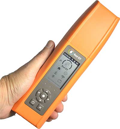
Bad Elf LLC has completed transition of all Bad Elf Flex receivers to the Hemisphere GNSS Phantom OEM module.
Photo: Bad Elf
As one of the first partners to incorporate the Phantom, Bad Elf Flex offers significantly enhanced capabilities and further exemplifies the company’s commitment to future-ready GNSS designs.
“We tested the Phantom OEM modules extensively, and confirmed they deliver the promised power savings and performance improvements when integrated with the Bad Elf Flex,” said Larry Fox, Bad Elf’s vice president of marketing and business development. “Hemisphere’s technology allows us to democratize GNSS through Bad Elf Flex.”
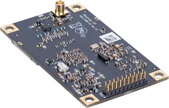
The new Phantom modules deliver a 30% gain in battery life, superior performance and scalable access to every GNSS constellation and signal, including GPS, Galileo, GLONASS, BeiDou, QZSS, IRNSS, SBAS and Hemisphere’s Atlas L-band, Fox said.
Photo: Hemisphere GNSS
Bad Elf Flex is a scalable-accuracy GNSS receiver with a daily option to choose between L-band and real-time kinematic (RTK). In standard configuration, it achieves 30-60 cm accuracy in real-time for GIS use.
Consuming a Bad Elf Flex Token unlocks a full RTK workflow for a 24-hour period to deliver 1-cm horizontal accuracy. Bad Elf Flex stores the tokens directly on the receiver, making them available for use anytime and anywhere. Customers requiring high accuracy at all times can purchase the Bad Elf Flex Extreme bundle, with RTK capabilities permanently unlocked, for a one-time upgrade fee.
Surveyors and their crews now have a scalable-accuracy, survey-grade receiver. GIS managers can focus on flexible field choices for work crews with varying skill levels. Bad Elf Flex falls within most capital expense budgets, allowing businesses to obtain operational and financial efficiencies.
“Bad Elf saw an opportunity to offer the GIS community a product lineup with better than 3-meter accuracy for under $3,000,” said John Cunningham, Bad Elf’s chief executive officer. “We began three years ago with our 2-meter ($300) and 1-meter ($600) mapping-grade product offerings. Our customers continued asking us to address the 50 cm, 10 cm and 1 cm requirements for their businesses. We worked hard over the past two years to build a platform, Bad Elf Flex ($3,000), that addresses these needs without breaking budgets. We have a solution that works today and provides a foundation to meet future customer requests. We love learning from our customers and look forward to continuing this conversation and extending high-accuracy GNSS for all.”
“Hemisphere is excited that Bad Elf’s Flex series now features our latest generation GNSS receiver,” said Miles Ware, director of marketing at Hemisphere. “We believe the scalable accuracy option made possible by our high-performance Atlas L-band correction service will be a game-changer in their served markets.”
SBG Systems renews its popular line of miniature inertial sensors with high-end functionalities and dual frequency RTK
SBG Systems has announced the third generation of its Ellipse series of miniature inertial sensors. The renewed product line benefits from a 64-bit architecture, allowing high precision signal processing.
All of the INS/GNSS devices now embed a dual-frequency, quad constellations GNSS receiver for centimetric position and higher orientation accuracy.
SBG Systems manufactures miniature high-accuracy inertial navigation systems with inertial measurement unit (IMU) design, calibration and filtering. All improvements made in the high-end lines could naturally benefit the Ellipse miniature line.
The Ellipse series includes four models.
Ellipse-A is a motion sensor
Ellipse-E provides navigation with an external GNSS receiver
Ellipse-N is a single-antenna RTK GNSS/INS
Ellipse-D is a dual-antenna RTK GNSS/INS
With its new 64-bit architecture, the third-generation Ellipse series enables the use of high-precision algorithms and technology used in high-end inertial systems such as rejection filters and FIR filtering.
All Ellipse miniature INS are now RTK-enabled without extra cost, and output raw data for post-processing. All these features are made possible in a small, robust aluminum-enclosure box version, as well as in the 17-gram OEM version.
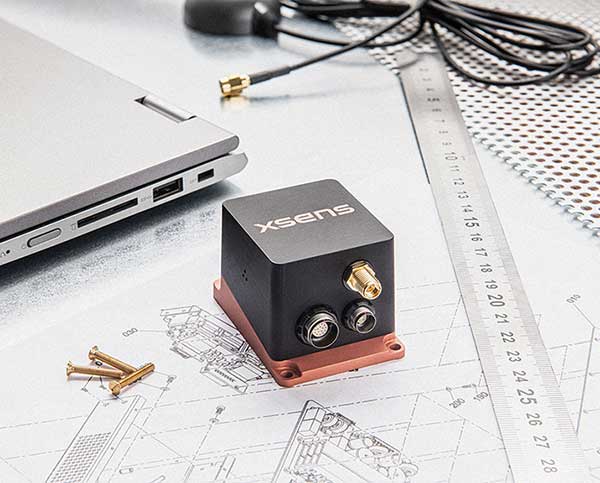
The 17-gram OEM version of the Ellipse-D can provide drones with high-end features. Its dual antennas gives UAVs robust instant heading for take-off. Dual antenna is achievable with a very short baseline, down to 50 centimeters. Integration is enabled with ROS and PX4 drivers, full API, and free phone and email technical support.
Ellipse-D
Ellipse-D is the smallest dual-frequency, dual-antenna RTK GNSS/INS device offered.
With its dual-frequency RTK GNSS receiver, the Ellipse-D provides a centimeter positioning. Dual frequency provides more robust heading and position computation than single-frequency receivers. It also allows high performance in attitude (0.05°) and in heading (0.2°).
With its dual-antenna capability, Ellipse-D provides precise heading in a few seconds, in all dynamic conditions, and even in challenging GNSS conditions. It is also immune to magnetic disturbances. Ellipse-D is a quad-constellation receiver, simultaneously using signals from GPS, GLONASS, BeiDou and Galileo to enable navigation in challenging conditions.
Designed with high quality industrial-grade components, Ellipse inertial sensors are highly tested and calibrated in dynamic and temperature for consistent, repeatable behavior in all conditions.
Xsens, manufacturer of motion-tracking modules, has launched real-time-kinematic (RTK)-compatible motion trackers. The development is designed to bring centimeter-accurate positioning within reach of a new generation of affordable commercial devices.
The RTK extension to conventional satellite positioning signals reduces the maximum positioning error from around ±1 meter in standard commercial GNSS receivers to typically ±2 centimeters. Companies developing innovative new products in non-military markets such as smart farming, autonomous vehicles and coastal maritime equipment have been keen to take advantage of high-precision RTK capability to enable new applications and more automated functions, according to an Xsens press release.
The MTi-680G is a new product in the Xsens MTi 600-series. The MTi-680G, an integrated GNSS/inertial navigation system (INS) module, features an integrated RTK GNSS receiver, as well as providing synchronized 3D attitude (tilt, inclination) and heading outputs.
The new MTi-680G also features upgraded firmware that substantially accelerates the module’s internal signal processing compared to non-RTK modules. Synchronizing the global position coordinates with the module’s attitude, heading and velocity outputs, the MTi-680G can provide a comprehensive positioning and navigation output for any carrier device, including of devices such as drones that move at high speed, at a maximum output data rate of 400 Hz.
The RTK-enabled module also offers these features:
Precise factory calibration of every production unit
High immunity to magnetic interference
Adaptive firmware operation to optimize performance in various types of scenario
Easy-to-use, free MT Software Suite developer tools to accelerate integration into end-product designs
Out-of-the-box operation with Xsens’ MTi development kits
“Centimeter-accurate positioning at an affordable price for commercial applications — this is the promise of the new RTK-compatible MTi-680G product,” said Boele de Bie, Xsens CEO. “From seed-sowing agricultural robots to autonomous cargo ships, a whole new generation of applications is now possible thanks to the centimeter-level accuracy of the MTi-680G’s position measurements.”
Qinertia, SBG Systems’ PPK software, now supports third-party IMUs and offers a GNSS post-processing license covering all major GNSS receivers
Screenshot: SBG Systems
SBG Systems’ INS/GNSS post-processing kinematic (PPK) software Qinertia now covers all surveyors’ projects by offering a license dedicated to GNSS post-processing. Open to the world, Qinertia supports all major GNSS receivers and is now open to third-party inertial measurement units (IMUs).
Qinertia has been designed to offer a comprehensive suite of post-processing software to geospatial professionals. It accepts all major GNSS manufacturers, and supports proprietary protocols from NovAtel, Septentrio, Trimble and u-blox for a straight-forward workflow.
The full-featured post-processing software offers native support for u-blox F9 real-time kinematic (RTK) receivers, reducing the workflow to a simple “drag and drop” to guarantee data integrity and accuracy.
Qinertia has been designed to help surveyors get the most of their surveys easily with a simple workflow, powerful quality control tools and tightly coupled algorithms. All of this is available to any surveyor with the new support of third-party IMUs or GNSS receivers. Several IMUs and inertial navigation systems (INS) have already been successfully integrated with Qinertia including Northrop Grumman’s LN-200 and LCI-100 and the Inertial Sense µIMU.
The new Qinertia GNSS license allows surveyors to post-process both static and kinematic GNSS data. In just a few clicks, surveyors can improve their trajectories, access RTK corrections worldwide, or even control a base-station’s precise location using precise point positioning (PPP) static computations.
GIS and Photogrammetry. Whether they fly a UAV or drive a car, professionals can improve their image location accuracy. Qinertia has been designed to help surveyors get their GIS or photogrammetry projects way more precise, by exporting a centimetric position for each picture at the exact shutter event.
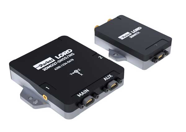
Parker LORD has launched the 3DM-GQ7 dual-antenna RTK inertial navigation system with multiple integrated aiding sensors and support for external aiding.
It has two integrated real-time kinematic (RTK)-capable multi-band multi-constellation GNSS receivers, integrated barometric pressure sensor, magnetometer, and hardware support for wheel odometry. It also has an application programming interface (API) for external sensor measurements.
The 3DM-GQ7 offers advanced sensor fusion for accurate measurements in challenging environments. It provides seamless operation during temporary GNSS signal outages and online tracking of inertial measurement unit (IMU) error sources for superior dead-reckoning.
An optional network RTK receiver, the 3DM-RTK, allows users to connect and communicate to the company’s SensorCloud RTK Connection network. This makes for an all-in-one solution (GNSS-INS + RTK + SensorCloud RTK).
3DM-GQ7 Features
High quality position, velocity and attitude estimates at rates up to 1 kHz
2-cm position accuracy (in good conditions with RTK corrections available)
0.1 degree roll/pitch accuracy; 0.25 degree heading accuracy with dual-antenna GNSS, depending on conditions
All-in-one system solution (GNSS-INS + RTK + SensorCloud RTK)
Applications include drones, autonomous vehicles and legged robots
This insight column from Septentrio explains the role of GNSS corrections in precise positioning. It explores the three most popular correction methods: RTK, PPP and PPP-RTK.
Let’s say you need reliable accurate global positioning in your technology. You do some research and decide to get yourself a multi-frequency GPS/GNSS receiver. You order an evaluation kit, but how to get your receiver to deliver the high accuracy that it promises?
GNSS receivers rely on external corrections to compensate for GNSS errors to achieve decimeter- or centimeter-level accuracy as fast as possible.
Correcting GNSS errors
GNSS-based positioning is calculated using a method that, by itself, is limited in accuracy due to several errors caused by GNSS satellites as well as the Earth’s atmosphere.
Even the advanced clocks on board GNSS satellites experience minute drifts that cause clock errors.
The movement of GNSS satellites is predicted as they orbit the Earth. These predictions are not perfect, which results in orbit errors.
Satellite equipment introduces small signal errors, which are modeled as satellite biases.
Atmospheric errors caused by distortions and delays are experienced by the signal as it passes through the Earth’s ionosphere (outer layer) and troposphere (layer near the Earth’s surface).
The local environment around the receiver as well as the receiver itself can introduce errors. For example, satellite signals can be reflected off buildings and tall structures (multipath).
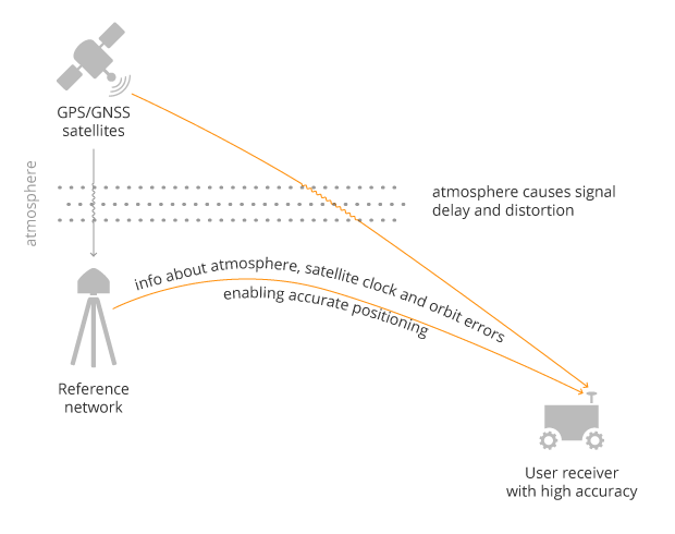
A GNSS receiver cannot correct satellite and atmospheric errors by itself; it relies on data provided by an external source. Clock and orbit errors are satellite-dependent, and so are the same around the world. Atmospheric errors, on the other hand, depend on the path the signal takes as it travels from the satellites to the user, differing depending on the receiver’s location.
To overcome both satellite and atmospheric errors, a reference station (also known as a base station) can be used. A reference station — a GNSS receiver installed at a fixed and precisely known location — estimates GNSS errors and sends them in the form of GNSS corrections to the user receiver. A reference network consists of interconnected reference receivers spread over a geographic area.
A user receiver gets data sent from a GNSS reference station to correct satellite and atmospheric errors. (Image: Septentrio)
Receiver-side errors can only be handled partially, by robust receiver technology and careful operation. Depending on which type of corrections are applied, it can take a few seconds to several minutes of initialization time for high accuracy to be achieved.
Types of corrections for high-accuracy positioning
Until recent years, RTK and PPP have been the established methods of providing GNSS corrections to user receivers. But the demand for high-accuracy positioning is on the rise, paving the way for new positioning techniques such as the hybrid PPP-RTK.
RTK: Highest level of accuracy. With the RTK (real-time kinematic) method, a user receiver gets correction data from a single base station or a local reference network. It then uses this data to eliminate most of the GNSS errors.
RTK is based on the principle that the base station and the user receiver are located close together (a maximum 40 kilometers or 25 miles apart) and therefore “see” the same errors. For example, since the ionospheric delays are similar for both the user and the reference station, they can be cancelled out of the solution, allowing higher accuracy.
While in the RTK method corrections are provided for a specific location, in the PPP and PPP-RTK methods, a correction model is broadcast to a larger area, but with slightly lower accuracy. To transmit this correction model, a message format called SSR (Space State Representation) can be used. There is some confusion in the industry about the term “SSR” since it is often associated with the newer PPP-RTK method. But be careful, since “SSR” is occasionally used as a buzzword to refer to traditional PPP services as well.
PPP: Globally accessible and accurate, but at a cost. Precise point positioning (PPP) corrections contain only the satellite clock and orbit errors. Since these errors are satellite specific, and thus independent of the user’s location, only a limited number of reference stations is needed around the world. Because atmospheric errors are not included in PPP corrections, only a lower accuracy level can be achieved with this method. Also, a longer initialization time is expected of up to 20-30 minutes, which may not be practical for some applications. PPP has been traditionally used in the maritime industry; today it has expanded to various land applications such as agriculture as a convenient way to get global GNSS corrections.
PPP-RTK: Best of both worlds? PPP-RTK (a.k.a. SSR) is the latest generation of GNSS correction services, combining near-RTK accuracy and quick initialization times with the broadcast nature of PPP. A reference network, with stations about every 150 kilometers (100 miles), collects GNSS data and calculates both satellite and atmospheric correction models.
As explained above, atmospheric corrections are regional, and so a denser reference network is needed than for PPP. These corrections are then broadcast to subscribers in the area via internet, satellite or telecom services. Subscribed receivers use the broadcast correction model to deduce their location-specific corrections, resulting in sub-decimeter accuracy.
Comparing the three GNSS correction methods
The table below compares the three correction methods, highlighting their strengths and weaknesses.
Table: Septentrio
The infrastructure density and initialization time for all three methods vary with the different kinds of errors that are corrected. The broadcast nature of PPP-RTK and PPP, as well as the lighter infrastructure that they require, makes these methods scalable for mass-market applications.
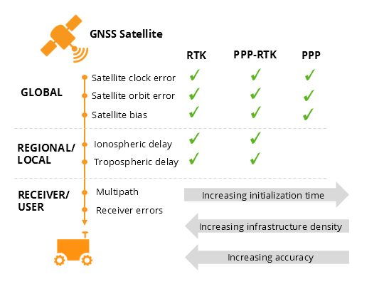
Types of errors that are corrected by each of the three methods. (Image: Septentrio)
Some GNSS receivers also incorporate advanced positioning algorithms to compensate for receiver-side issues such as multipath (for example, see Septentrio APME+), jamming and spoofing. This adds reliability and robustness to high-accuracy positioning.
Getting GNSS corrections
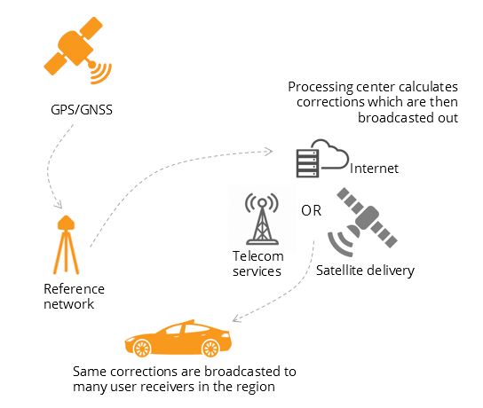
Modern industrial receivers often get their GNSS corrections via a subscription service, delivered via internet (using NTRIP protocol), satellite or 4G/5G. Today, there is a boom in the correction-service market driven by high-accuracy demands of the automotive industry, automation and smart consumer devices. Automotive suppliers and many other new players are deploying infrastructure to set up services for centimeter-level positioning around the globe.
User receivers often get their GNSS corrections via a subscription service delivered via internet, satellite or 4G/5G. (Image: Septentrio)
PPP and PPP-RTK corrections can even be transmitted directly by the GNSS satellites, as in the Japanese CLAS service from the QZSS constellation, or in the planned High-Accuracy Service (HAS) from Galileo. Depending on the network density and quality of the error modeling, different initialization times and accuracies can be achieved. This means that positioning quality can vary from one service provider to another.
Major telecom companies such as Deutsche Telekom as well as the Japanese Softbank and NTT are equipping their infrastructure with GNSS receivers to enable new corrections services. 3GPP, which provides specifications for mobile telephony including LTE, 4G and 5G, now covers broadcasting of GNSS satellite corrections in its mobile protocol. Since reference receivers are becoming part of critical infrastructure, such as telecom towers, it is essential that they have a high level of security to protect them from potential jamming or spoofing attacks (for example, Septentrio AIM+ technology).
Which corrections are right for me?
The right correction service for your technology will depend on your location and service area, your accuracy and reliability needs, as well as your budget. Because the corrections market keeps expanding, it is now more important than ever that integrators or GNSS manufacturers assist you in selecting the best correction method for your industrial application.
If you choose a GNSS receiver which does not “lock” you to a certain correction service, you will be free to choose a correction method which is most suitable for your application and its location. Such “non-locking” open-interface receivers also offer customers flexibility to switch to another more beneficial service in the future, as correction methods keep evolving.
Gladiator Technologies’ low-noise inertial sensor and systems technology coupled with Velox high-speed processing are now integrated with a 72-channel GNSS receiver to provide compact GNSS/inertial navigation systems (INS) for accurate position, velocity and attitude.
The feature set was carefully selected to suit several positioning, navigation and timing (PNT) applications including flight control, navigation and stabilization for imaging, platforms and antennas.
The high-performance LandMark 60 INS/GPS and compact LandMark 005 INS/GPS both feature advanced sensor-fusion technology, combining GNSS position data with Gladiator Technologies’ low-noise, high output inertial sensors as well as barometric pressure and magnetometers.
Both products feature Gladiator Technologies’ proprietary Velox processing technology and extended Kalman filter (EKF), enabling precision position information during short-term GPS outages.
Velox Technology combined with the new EKF enable the LandMark INS/GPS products to have accuracy of less than 2 nautical miles per hour during short-term GPS outages.
The LandMark 60 INS/GPS is the top performing unit with +/- 0.3° heading accuracy and pitch/roll angle measurements of 0.1°. It is also available with an option for a real-time kinematic (RTK) GPS receiver.
The small and robust LandMark 005 INS/GPS is less than 35 square centimeters and is suitable for space-constrained applications that require a high standard of INS/GPS performance.
“Our low-noise sensor inputs to the EKF are enhanced by an adaptive estimation algorithm,” said Lee Dunbar, chief software architect. “This, along with extended precision for the nonlinear solution integrator, maximizes the accuracy of position, velocity and attitude. Customer configurable EKF parameters are present to allow optimization for their applications.”
“Leveraging our inertial capability into a complete INS/GPS package was a natural progression for our product line,” said Eric Yates, Gladiator Technologies’ new business development manager. “With the LandMark 005 INS/GPS and LandMark 60 INS/GPS we’re offering an exceptional MEMS-based INS/GPS that fits in the palm of your hand.”
The John Deere StarFire 6000 RTK receiver operating in the field. (Photo: John Deere)
Precision agriculture — the practice of optimizing inputs of seed, water, and fertilizers while maximizing yields by mapping variations in soil characteristics and guiding machinery accordingly — began in the United States in the early 1980s and has been growing steadily. Key components include soil mapping based on sampling and remote sensing, proximal sensing of soils and crops, variable rate irrigation and variable rate spraying of fertilizers and herbicides, and automatic tractor navigation.
“GNSS-based guidance is probably the most highly adopted precision ag technology, followed by variable rate and section control,” said John Fulton, associate professor at The Ohio State University. “I suspect that somewhere around 40% of those GNSS receivers use RTK-level corrections — which provide sub-inch accuracy — and that number is increasing.”
Need for sub-inch accuracy
Water runs downhill, of course, which makes vertical accuracy critical for hydrology. “AgLeader builds a plow to put tile in soil to drain water,” said Bill Cran, AgLeader Technology’s GNSS product specialist. “It might only be 4 inches round; so, if we are off by 2 or 3 inches vertically, that affects where water can run.” To get the best vertical accuracy possible, he recommends farmers install a base station in the field where they are operating.
Sub-inch accuracy also enables farmers to determine where to plant each seed, rather than monitoring planters at the row level. “That may not be a requirement today, but it is certainly coming,” Cran said.
Market demand for RTK in agriculture is increasing, an important factor for drone guidance or machine control, said Gustavo Lopez, market access manager at Septentrio. “The robots are very close to the crops. When small robots are working in a corn field, the corn plants are causing multipath or shadowing GNSS signals,” Lopez said. “You need either a good RTK or GNSS-INS, because if you lose satellite lock you can still coast for a while with an IMU.”
Services and options
AgLeader’s displays have a built-in networked transport of RTCM via internet protocol (NTRIP) client that enables it to connect to NTRIP networks and CORS networks, as well as other free and subscription-based networks. “That allows us to get RTK from the internet for customers that want to go that route,” Cran said. Alternatively, the company offers NovAtel GPS receivers, including Satel- or Freewave-based RTK options with 400 MHz and 900 MHz radio options that can communicate with a similar base station. This spring, it will begin to offer NovAtel’s TerraStar-X service. “We are calling that ‘RTK from the sky,’” Cran said. “The expectation is sub-inch accuracy, with a convergence time of less than one minute. Many of our customers and dealers are very excited about that option.”
Septentrio’s GNSS modules for agriculture are used mostly in mapping drones, Lopez said. The modules mitigate interference and spoofing. “We have also been quite successful in robotics for agriculture,” Lopez said. Septentrio is working closely with the French agriculture robotics company Naïo Technologies, which integrates its robots with Septentrio’s smart antenna GNSS products, providing a full RTK solution as well as autonomy.
For areas without RTK networks, some farmers buy and install Septentrio base stations that provide corrections to their robots or UAVs. Septentrio provides agricultural mapping software for post-processing data gathered without RTK. Also on offer are L-band receivers — while not as accurate as a local RTK network and possibly with higher convergence time, the relative accuracy of L-band corrections is more than good enough for many ag robots, Lopez explained.
On the baseline
The vegetable weeding robot Dino — shown here operating in Yuma, Arizona — uses a Septentrio GNSS receiver. (Photo: Septentrio/Naio Technologies)
Most RTK users are on a short baseline — under 5 miles from the base station to the rover, according to Al Savage, manager of John Deere’s StarFire network. Medium baseline is about 5–8 miles, and long baseline is up to 12 miles. In 2015 John Deere released its Base Station Manager, which enables dealers to remotely upload firmware, upkeep the rover access list, and monitor their base stations.
As dealerships and their RTK networks merged and farms expanded, it became difficult for farmers to keep track of which base station to use. So, in 2019 John Deere released an Automatic Base Station Switching feature that links the RTK radio configuration to the field boundary in its Generation 4 display.
Also new: A John Deere StarFire receiver can continue to operate if it loses connection to a base station using the RTK Extend feature. The StarFire SF6000 rover receiver can continue operating with RTK-like accuracy for up to 14 days without connecting to an RTK base station, compared to only 14 minutes for a previous receiver, Savage explained. The increase “was very well received by customers, especially those operating in areas challenged by line of sight or trees and foliage on field boundaries.”
In South America, John Deere’s RTK Flex feature, “will automatically switch between RTK and SF3 during a time in the day when scintillation causes the greatest interference,” Savage said, enabling farmers “to continue working with similar accuracy when RTK is unavailable due to scintillation.”
Remaining obstacles to adoption
Despite’s RTK’s growing popularity, there are a few remaining obstacles to its adoption.
Cost. “Though the cost has been greatly reduced over the years, RTK is still more expensive than other correction signals out there,” Fulton said. Part of the cost is due to the hardware, Cran pointed out. “There are rover and base station radios, there are towers to put up. On the NTRIP side, there are cell modems to put in vehicles, and they require keeping a data plan active.” The agriculture market traditionally has been very cost-sensitive and conservative, Lopez said. “Farmers expect to implement very low-cost solutions. They want to know whether they will have an ROI (return on investment) on these solutions.”
Satellite services offer a cheaper alternative to RTK. TerraStar-X, for example, gets rid of the cell modem hardware and the requirement for base station hardware, Cran said. “At a lower accuracy level, there are other satellite-based TerraStar signals: TerraStar-C and TerraStar-C Pro, which get an accuracy maybe under 5 to 20 cm. Those are less-expensive alternatives that growers are using without making the leap to RTK.”
Lack of Internet Connectivity. While most RTK services, including NTRIP, require an internet connection, many rural areas have limited broadband and even cellular connections. Some areas lack support for RTK, Fulton said.
Lack of cross-platform compatibility. Farmers with a mixed fleet want to run a mix of receivers. “For example, John Deere and Trimble RTK do not work together,” Cran said. “It is still very manufacturer-specific. I cannot take a NovAtel receiver that is AgLeader branded and use it with a John Deere RTK network.” NTRIP partially enables cross-platform mixing and matching. “We’re excited about TerraStar-X, too, because, while it is specific to NovAtel receivers, it is not tied to any base station hardware,” Cran said. “So, a John Deere guy can put an AgLeader receiver on their vehicle and use TerraStar-X and still get that accuracy without being tied to the Deere RTK network.”
Liability. While safety is not nearly as big an issue as it is with autonomous vehicles on the roads, liability questions will soon loom. “If, for example, a robot destroys a whole plantation, someone must be liable,” Lopez pointed out. “Was it the robot? The GPS receiver? Other sensors? The farmer? What if there is a spoofing attack and the robot goes to a neighbor’s field?” Such challenges are slowing adoption. “That is where the reliability of the GNSS is becoming important,” he said.
The future
Soon, satellite-based internet connections could make RTK correction more widely available and give more growers the option of using NTRIP, though at a cost. WAAS, a free service of the U.S. government, is broadcast by satellites but does not achieve the accuracy level of RTK. “RTK is still a localized correction,” Fulton said. “We may see that shift to satellite, but it will more likely be an online or some other type of communication.
“Once farmers start using RTK, it is very unlikely that they will ever revert to another type of correction,” he added.“RTK is a very addictive correction service for folks.”
Savage concurs. “RTK is addictive because of its accuracy, efficiency and repeatability.” Ultimately, however, to achieve universal adoption, RTK solutions will need to work everywhere, with little intervention by the farmer.