Planet’s Deven Desai explains how Planet uses satellite imagery to uncover data for the oil and gas industry, as well as for road detection, at the 2019 Esri User Conference in San Diego.
Tag: satellite
-
NASA releases satellite damage map of Camp Fire
The Advanced Rapid Imaging and Analysis (ARIA) team at NASA’s Jet Propulsion Laboratory in Pasadena has produced a map showing the damage caused by the Camp Fire in Northern California.
After two and a half weeks of historic destruction, the fire is now 100 percent contained. Teams continue to search the destruction — including the destroyed town of Paradise — for remains. As of Sunday, the death toll is 85, making it California’s deadliest fire.
The map shows the damage as of Nov. 16.

Credits: NASA/JPL-Caltech The map was developed using synthetic aperture radar images from the Copernicus Sentinel-1 satellites operated by the European Space Agency.
The map covers an area of 48 miles by 48 miles (78 by 77 kilometers), outlined in red on left. A closeup view of damage to the town of Paradise is inset on right, outlined in white. The color variation from yellow to red indicates increasingly more significant changes in the ground surface.
The ARIA team creates its maps by comparing before-and-after satellite images of the fire region to see the extent of change between the two images. For this map, they compared the data for the image to a Cal Fire map for preliminary validation.
Although the maps may be less reliable over vegetated terrain, such as forests, they can help officials and first responders identify heavily damaged areas and allocate resources as needed.
Sentinel-1 data were accessed through the Copernicus Open Access Hub. The image contains modified Copernicus Sentinel data (2018), processed by ESA and analyzed by the NASA-JPL/Caltech ARIA team.
-
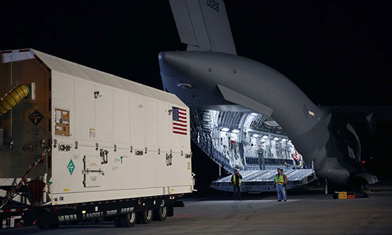
Lockheed gets U.S. Air Force contract for 22 more GPS IIIs
The U.S. Air Force has awarded Lockheed Martin a $7.2 billion contract to build 22 more GPS III satellites.
Like the first batch of 10 GPS III satellites, the GPS III Follow-On (GPS IIIF) satellites “will provide greater accuracy, and improved anti-jamming capabilities, making them more resilient,” said Air Force Secretary Heather Wilson in a statement.
The satellites will be built at the company’s Waterton campus in the Denver suburb of Littleton.
Under a previous contract, Lockheed is in the process of building 10 GPS III satellites, the first of which is slated to launch in December. The first GPS IIIF satellite could be ready for launch in 2026.

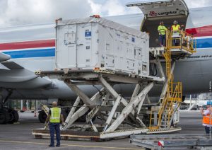
GPS III SV01 on Aug. 20 boards a U.S. Air Force C-17 for its flight to Cape Canaveral, Florida. (Photo: Lockheed Martin) “We’re grateful for the U.S. Air Force’s continued confidence in Lockheed Martin on the GPS III/IIIF program,” said Johnathon Caldwell, Lockheed Martin’s program manager for Navigation Systems. “We’ve worked hard to develop and produce GPS III to help the Air Force modernize the GPS constellation with new, more powerful, and more resilient, technology.
“This new contract for GPS IIIF will bring GPS to a whole new level. It takes full advantage of our flexible satellite design to incorporate additional new technology like a 100% digital navigation payload, Regional Military Protection and new search-and-rescue payloads into the constellation. We are proud to be bringing these new capabilities to our warfighters and the world.”
Both Boeing and Northrop Grumman declined to bid on the contract, leaving Lockheed Martin the lone provider.
-
Satellite imagery details historic floods in India
DigitalGlobe has released pre- and post-event satellite imagery of the areas in India affected by heavy flooding.
According to the company, massive flooding devastated the Kerala state of India in late May and early August. At least 164 people were killed and more than 223,000 were displayed from their homes and are living in relief camps. In addition, Kerala has seen 40 percent more rainfall than normal since June, which has triggered landscapes in several districts.
In an effort to support disaster response and as a part of its Open Data Program, DigitalGlobe decided to publicly release the satellite images. According to the company, its Open Data Program supports the humanitarian community by providing critical and actionable information to assist response efforts.
Check out the before and after images below.

An overview of the fields and villages before the flood in the Kerala state of India in March 2018. (Satellite image ©2018 DigitalGlobe, a Maxar company.) 
An overview of the fields and villages during the flood in the Kerala state of India in August 2018. (Satellite image ©2018 DigitalGlobe, a Maxar company.) 
Before the flood in Champakulam in March 2018. (Satellite image ©2018 DigitalGlobe, a Maxar company.) 
A closeup of the flood in Champakulam in August 2018. (Satellite image ©2018 DigitalGlobe, a Maxar company.) 
Before the flooding in Moncompu, Kerala, in March 2018. (Satellite image ©2018 DigitalGlobe, a Maxar company.) 
During the flooding in Moncompu, Kerala, in August 2018. (Satellite image ©2018 DigitalGlobe, a Maxar company.) 
An overview of the roads and villages before the flooding in Kerala in March 2018. (Satellite image ©2018 DigitalGlobe, a Maxar company.) 
Trapped cars are on the roads in Kerala during the flooding in August 2018. (Satellite image ©2018 DigitalGlobe, a Maxar company.) 
People are stranded on a road southeast of Champakulam in August 2018. (Satellite image ©2018 DigitalGlobe, a Maxar company.) 
Vehicles are trapped on a road southeast of Champakulam in August 2018. (Satellite image ©2018 DigitalGlobe, a Maxar company.) -

Galileo launches four more satellites
The European Space Agency launched the next four Galileo satellites on an Ariane 5 on Wednesday July 25, at 11:25 GMT (13:25 CEST, 08:25 local time) from Europe’s Spaceport in Kourou, French Guiana.
These latest four Galileo satellites will bring the constellation in orbit up to 26 satellites.
You can watch the launch live starting at 4 a.m. local time.
Livestream coverage of the launch starts at 11:00 GMT (13:00 CEST) with liftoff at 11:25 GMT (13:25 CEST).
Live coverage resumes with confirmation of the satellites separating from their upper stage from 14:50 GMT (16:50 CEST).
Separation of the Ariane 5’s upper stage occurs about nine minutes after liftoff, followed by the first 10-minute firing of the upper stage.
The upper stage — carrying four 715-kg Galileo satellites — flies in ballistic configuration for three hours and eight minutes, after which a second upper stage firing lasting just over six minutes will place it into circular separation orbit.
Once stabilized at 3h 36 min after liftoff, the Galileo dispenser will release the first two satellites, followed by the second pair 20 minutes later.
In the meantime, check out ESA’s new Galileo video.
The Ariane 5 carrying Galileo satellites 23-26 is in place at the ZL3 launch site ready for liftoff. (Photo: ESA) -
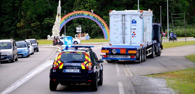
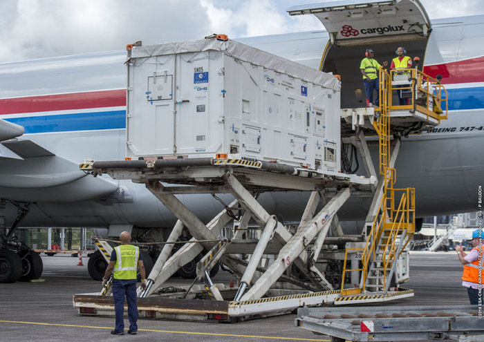
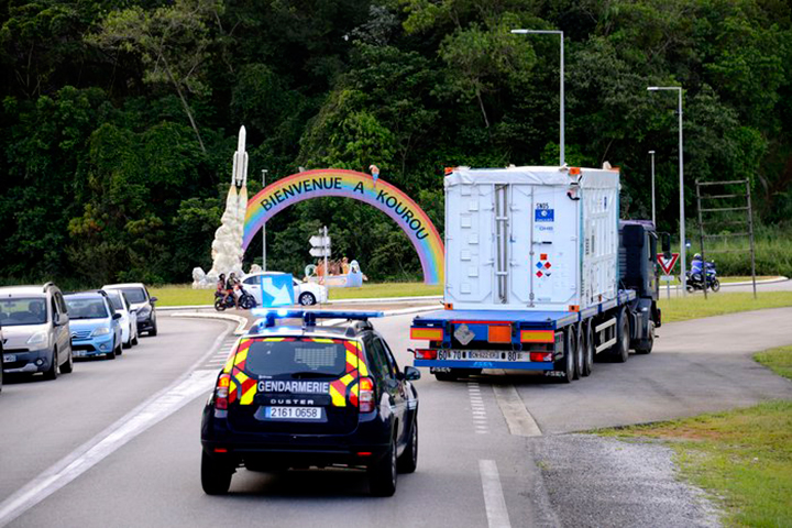
Galileo pair arrive at spaceport for July launch
News from the European Space Agency
The next two satellites in Europe’s Galileo satellite navigation system have arrived at Europe’s Spaceport in Kourou, French Guiana, ahead of their planned launch from the jungle space base in July.
Galileo satellites 23 and 24 left Luxembourg Airport on a Boeing 747 cargo jet on the morning of May 4, arriving at Cayenne – Félix Eboué Airport in French Guiana that evening.
Arrival at the Felix Eboué airport on April 5, 2018. (Photo: ESA) They were then unloaded, still in their protective air-conditioned containers, and transported by truck to the cleanroom environment of the preparation building within Europe’s Spaceport.
This pair will be launched along with another two Galileo satellites, which are due to be transported to French Guiana later this month.
The quartet will be launched together on a customized Ariane 5 on July 25.
The Galileo System began Initial Services on Dec. 15, 2016, and a growing number of commercial devices are using Galileo today. Completion of the constellation should improve Galileo’s positioning accuracy further still.

One of two Galileo satellites being driven by truck to the Guiana Space Centre inside its container. Galileo satellites 23 and 24 left Luxembourg Airport on a Boeing 747 cargo jet on the morning of May 4, arriving at Cayenne – Félix Eboué Airport in French Guiana that evening. (Photo: ESA) But Galileo satellites will continue to be launched into the future: a further 12 Galileo “Batch 3” satellites were ordered last June, supplementing the 26 built so far to provide further in-orbit spares, and replacements for the oldest Galileo satellites, first launched in 2011.
A steady stream of orbital spares, ready to replace satellites reaching the end of their operational lives, is essential to ensure Galileo continues operating seamlessly.
Looking further ahead, with the aim of keeping Galileo services as a permanent part of the European and global landscape, replacement satellites will be required by the middle of the next decade, offering improved performance and added features.
-
China launches another pair of BeiDou-3 satellites
China continues to update the BeiDou navigation satellite system. On Feb. 12, two more navigation and positioning satellites were launched into medium Earth orbits, following the successful launch of a pair of BeiDou satellites on Jan. 11.
A Long March 3B rocket with a Yuanzheng-1 upper stage lifted off from the Xichang Satellite Launch Center, Sichuan Province, at 13:03 local time (05:03 UTC), according to gbtimes.com.
Stay up-to-date with our Upcoming GNSS Satellite Launches table, maintained by Richard Langley.
The launch had been set for the same window on Feb. 10, but was delayed by the visit of Chinese president Xi Jinping to the launch site.
Success of the mission was confirmed four hours after launch, following insertion of the satellites into their intended orbits, around 21,000 kilometers above the Earth.
The newly launched pair are BeiDou-3 28 and 29. The satellites are part of a third phase of Beidou deployment, which will take Beidou coverage from regional to covering the countries along the Belt and Road initiative by the end of 2018, and global by 2020.
According to Nasaspaceflight.com, the satellites are using a new bus featuring a phased array antenna for navigation signals and a laser retroreflector, with a launch mass of 1,014 kg.
The accuracy, stability and signal strength of the Beidou-3 satellites is improved over previous versions by developments in atomic clocks, laser communications and inter-satellite links.

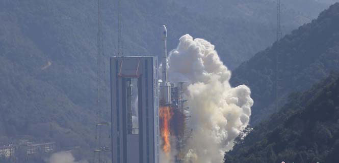
The Long March 3B/YZ-1 carrying Beidou satellites 28 and 29 lifts off from Xichang Satellite Launch Centre at 13:03 local time on Feb. 12. (Photo: CNS) -
UK government issues highest level study of SatNav vulnerabilities
A U.K. government report issued on Jan. 30 looks at the vulnerability of all satellite-based positioning systems: GPS, Galileo, GLONASS, BeiDou, QZSS and more. Issued by the Office of the Government Chief Scientific Adviser, Sir Mark Walport, and informally called the Blackett Report, designating the highest level of government scientific studies, named after a UK physicist who won the 1948 Nobel Prize, the review aims to “lay out the breadth, scale and implications of our reliance on ‘the invisible utility’ mainly in terms of existing critical national infrastructure (CNI).”
“Satellite-derived Time and Position: A Study of Critical Dependencies” states in the forward that it “represents a vital step in understanding the UK’s dependency on GNSS and recommends measures to improve our resilience. Importantly, it also recognises that innovation will be key to realising, fully and safely, the economic and societal benefits offered by GNSS.”
The report points to the fragility of satellite positioning signals which can be affected by cheap jammers, spoofers, weather and interference from other radio signals — among other vulnerabilities. The 86-page PDF document is downloadable here.
The review incorporates the results of a separate but related study, issued in April 2017, looking at the fiscal consequences of a GNSS disruption in. “Economic Impact to the U.K. of a Disruption in GNSS” was briefly summarized in a June 2017 column from this magazine (scroll down to “At What Cost Ignorance?”). The report attempted to quantify the cost of a GNSS disruption, should one occur. The authors came up a figure of 5.2 billion pounds ($6 billion) for a 5-day disruption.
David Last, a UK consultant engineer specializing in radio navigation and communications systems, professor emeritus at the University of Bangor, Wales and past president of the Royal Institute of Navigation, consulted on the June 2017 economic impact report, and was a member of the expert panel and co-author of the January 2018 Blackett Report. He was to have given a presentation on them at the ION International Technical Meeting in Reston, Virginia on January, but could not make the trip. The following materials are drawn from his prepared presentation.
Some of the conclusions from the June 2017 economic impact study are:
- There are alternatives to GNSS, specific to each application
- However, there is no universally-applicable single alternative for positioning and navigation
- Among the most salient needs: higher quality (more expensive) oscillators for timing
- “The most applicable mitigation strategies for the largest number of applications are eLoran and Satelles.”
- “Omnisense and Locata may be preferred for localised applications that require high levels of accuracy.”
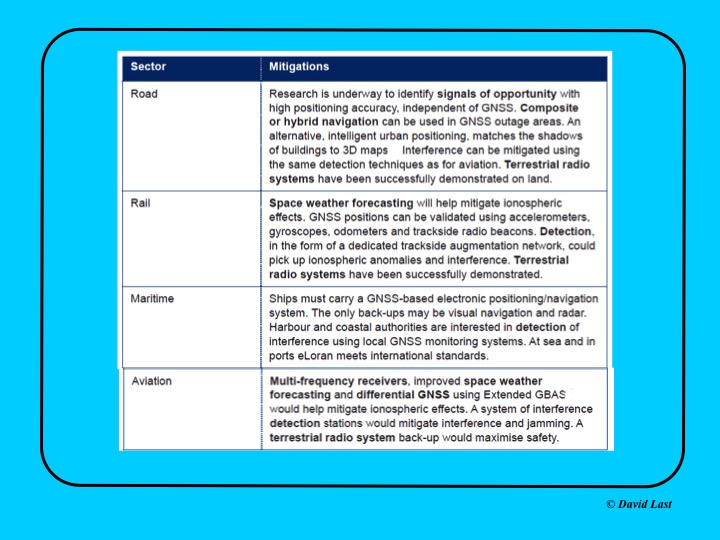
From the just-issued Blackett Report, the first figure displayed above presents recommended mitigations to impacts on GNSS applications in road, rail, maritime and aviation. Alternative options include composite or hybrid navigation, terrestrial radio systems, space weather forecasting, eLoran, various methods of interference detection, multi-frequency receivers and differential GNSS.
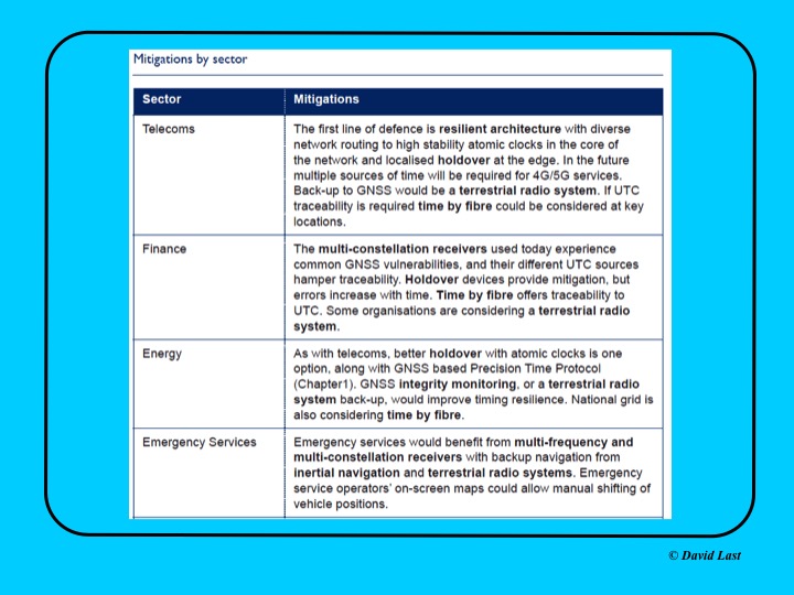
A second figure from Last’s presentation, shown above, covers the mitigations recommended for telecoms, finance, energy, and emergency services sectors. Mitigations for these applications include a resilient architecture with diverse network routing to high-stability atomic clocks, terrestrial radio systems, time-by-fiberoptics, multiconstellation receivers, holdover devices, GNSS integrity monitoring, and inertial navigation.
Concluding recommendations of the Blackett Report:
- CNI operators to review and report on their reliance on GNSS. Cabinet Office to assess overall dependence of CNI on GNSS.
- Add loss or compromise of GNSS-derived PNT to National Risk Assessment, not just as a dimension of space weather.
- In allocating radio spectrum to new services and applications, address the risk of interference to GNSS-dependent users, including CNI.
- Review the legality of the sale, ownership and use of devices and software to cause deliberate interference to GNSS receivers or signals.
- Assess the need to monitor interference of GNSS at key sites such as ports and share the data with government
- Employ GNSS-independent back-up systems.
- Cross-government PNT Working Group to report to Cabinet Office on ways to improve national resilience.
- Government to facilitate as those procuring GNSS equipment for CNI specify performance standards.
- Map PNT testing facilities and explore how industry and critical services can better access them.
- Leverage UK academic and industrial expertise in time and geo-location, increasing coordination among existing centres of excellence.
-

Four more Galileo satellites launched into orbit
Updated with additional details and reaction.

Liftoff of Ariane 5 Flight VA240 from Europe’s Spaceport in Kourou took place at 18:36 UTC on Dec. 12, 2017, carrying Galileo satellites 19–22. (Photo: ESA) On Dec. 12, four more Galileo satellites headed into space to join the navigation constellation. Galileos 19–22 lifted off aboard an Ariane 5 rocket from Europe’s Spaceport in Kourou, French Guiana, at 18:36 UTC (19:36 CET, 15:36 local time).
After today’s successful launch, only one more launch remains before the Galileo constellation is complete and delivering global coverage.
Separation of the upper stage occurred about nine minutes after liftoff, followed by the first firing of the upper stage.
The first pair of 715-kg satellites was released almost 3 hours 36 minutes after liftoff, while the second pair separated 20 minutes later.
They were released into their target 22,922 km-altitude orbit by the dispenser atop the Ariane 5 upper stage. In the coming days, this quartet will be steered into their final working orbits. There, they will begin around six months of tests — performed by the European Global Navigation Satellite System Agency (GSA) — to check they are ready to join the working Galileo constellation.
This mission brings the Galileo system to 22 satellites. Initial Services began almost a year ago, on Dec. 15, 2016.
“Today’s launch is another great achievement, taking us within one step of completing the constellation,” remarked Jan Wörner, ESA’s director general.
“It is a great achievement of our industrial partners OHB (DE) and SSTL (GB) for the satellites, as well as Thales-Alenia-Space (FR, IT) and Airbus Defense and Space (GB, FR) for the ground segment and all their subcontractors throughout Europe, that Europe now has a formidable global satellite navigation system with remarkable performance.”
Paul Verhoef, ESA’s director of navigation, added, “ESA is the design agent, system engineer and procurement agent of Galileo on behalf of the European Commission. Galileo is now an operating reality, so, in July, operational oversight of the system was passed to the GSA.
“Accordingly, GSA took control of these satellites as soon as they separated from their launcher, with ESA maintaining an advisory role. This productive partnership will continue with the next Galileo launch, by Ariane 5 in mid-2018.
“Meanwhile, ESA is also working with the European Commission and GSA on dedicated research and development efforts and system design to begin the procurement of the Galileo Second Generation, along with other future navigation technologies.”
Next year’s launch of another quartet will bring the 24‑satellite Galileo constellation to the point of completion, plus two orbital spares.
Keep up to date here.
-
Ground system ready for Joint Polar Satellite launch

The northernmost Joint Polar Satellite System Common Ground System station in Svalbard, Norway. (Photo: Raytheon) Newest version of Raytheon’s Joint Polar Satellite System Common Ground System is now operational
Raytheon’s next-generation Common Ground System for the Joint Polar Satellite System (JPSS CGS 2.0) is now operational, supporting 11 polar-orbiting satellites and delivering observations to NOAA’s National Weather Service almost 50 percent faster than before.
Svalbard, Norway, is the location of the northernmost Joint Polar Satellite System Common Ground System station.
JPSS CGS 2.0 was designed to support the upcoming NASA launch of NOAA’s JPSS-1 satellite on Nov. 14.
“The new ground system significantly improves the mission capabilities of the JPSS program,” said Matt Gilligan, vice president of Raytheon’s Navigation and Environmental Solutions. “It can handle even more data from the full constellation of satellites now and in the future.”
Developed by NASA for NOAA, the JPSS CGS collects and disseminates observations from polar-orbiting weather satellites from the United States, Europe and Japan.
The polar orbiters provide critical weather and environmental data to ensure meteorologists and forecasters have robust, reliable information to make timely and accurate weather predictions that help save lives, protect property and decrease the devastating economic impact caused by severe weather.
-

DigitalGlobe releases satellite imagery of Houston
DigitalGlobe released satellite imagery of Houston after Hurricane Harvey hit.
Hurricane Harvey slammed into the Gulf Coast of Texas — just southwest of Houston — on Aug. 25. According to DigitalGlobe, the hurricane packed sustained winds at more than 130 miles per hour and has been identified as the largest single rainmaking event in continental U.S. history.
The images show downtown Houston, George Bush Intercontinental Airport and the interstate highways, which are relatively dry. Significant flooding remains in towns east and north of Houston, including Kingwood, Highlands and Channelview, the company says.

Images courtesy of © 2017 DigitalGlobe 
Images courtesy of © 2017 DigitalGlobe 
Images courtesy of © 2017 DigitalGlobe 
Images courtesy of © 2017 DigitalGlobe
Images courtesy of © 2017 DigitalGlobe -
Two more satellites join Galileo constellation
Two further satellites have formally become part of Europe’s Galileo satnav system, broadcasting timing and navigation signals worldwide while also picking up distress calls across the planet, reported the European Space Agency.

Liftoff of Ariane flight VA233, carrying four Galileo satellites, on Nov. 17, 2016. These are the 15th and 16th satellites to join the network, two of the four Galileos that were launched together by Ariane 5 on Nov. 17, 2016, and the first additions to the working constellation since the start of Galileo Initial Services on December 15.
The growing number of Galileo users around the world will draw immediate benefit from the enhanced service availability and accuracy brought by these extra satellites.
The launch into space and the maneuvers to reach their final orbits still left a lot of rigorous testing before the satellites could join the operational constellation.
Their navigation and search and rescue payloads had to be switched on, checked and the performance of the different Galileo signals assessed methodically in relation to the rest of the worldwide system.

Galileo L-band antenna at ESA’s Redu ground station. This lengthy testing saw the satellites being run from the second Galileo Control Centre in Oberpfaffenhofen, Germany, while their signals were assessed from ESA’s Redu centre in Belgium, with its specialized antennas.
The tests measured the accuracy and stability of the satellites’ atomic clocks – essential for the timing precision to within a billionth of a second as the basis of satellite navigation – as well as assessing the quality of the navigation signals.
Oberpfaffenhofen and Redu were linked for the entire campaign, allowing the team to compare Galileo signals with satellite telemetry in near-real time.
Making the tests even more complicated, the satellites were visible for only three to nine hours a day from each site.
The satellites are now broadcasting working navigation signals and are ready to relay any Cospas–Sarsat distress calls to regional emergency services.
Now that these two satellites are part of the constellation, the remaining pair from the Ariane 5 launch is similarly being checked to prepare them for service.