SBG Systems will demonstrate Qinertia, its in-house next-generation INS/GNSS post-processing software, at the Intergeo trade show, which takes place Sept. 26-28 in Berlin.
SBG Systems can be found is in Hall 1.1, stand C1.007.
For more than 10 years, SBG Systems has been designing inertial navigation systems from the internal inertial measurement unit (IMU) to filtering with GNSS data.
Designed for the surveying market, Qinertia is a fully in-house INS/GNSS post-processing kinematic (PPK) software. Whether the survey is made from a car, a UAV, a plane or a vessel, Qinertia will secure and enhance a surveyor’s acquisition, the company said.
The company will hold four live demonstration at its stand during Intergeo. The demonstrations will take place at 11 a.m. and 15 p.m. on both Tuesday, Sept. 26, and Wednesday, Sept. 27. There is no need to book to attend a demonstration, but please note that seats are limited.
Q: Where is leading technology trending for UAV navigation in complex, unstructured, and uncertain (GNSS-denied) environments in industrial applications?
A: Tight integration between GNSS and inertial navigation systems (INS) can provide accurate, reliable navigation in GNSS-challenged environments, and advances in MEMS inertial technology continue to push the performance of systems that meet the size, weight and power requirements for UAV systems. These GNSS/INS sensors will continue to improve and form the core of the navigation system as additional navigation aids, such as computer vision, are added to address more demanding GNSS-denied applications.
Alexis Guinamard, Chief Technical Officer, SBG Systems
A: Industrial UAVs need trustworthy navigation units. Drastic sensor selection, thermal calibration, and signal processing techniques are mandatory to cope with high temperature / vibrating environments. Advanced algorithms design is also a key to make UAV navigation more reliable in challenging environments: An extended Kalman filter that fuses inertial and GNSS data maintains an accurate trajectory, even during GNSS outages. Next challenge is to get real-time inertial data fusion with GNSS, and vision or Lidar sensors!
Jan Van Hees, Director Business Development, Septentrio
A: Inertial sensors, vision and radar-based distance sensors provide positioning in GNSS-challenged environments. However, experience teaches that even there, GNSS signals can often be received, albeit intermittent or badly disturbed. And GNSS is still the easiest absolute positioning reference available. Therefore, much effort goes into developing robust GNSS technology with reliable quality information, which continues to play a crucial role in the positioning solution, fused with the aforementioned technologies.
Qinertia, SBG Systems’ new in-house post-processing software, gives access to offline real-time kinematic (RTK) corrections, and processes inertial and GNSS raw data to further enhance accuracy and secure a survey.
SBG Systems will unveil new software for the surveying industry at the Ocean Business show, held in Southamptom, United Kingdom, April 4-6.
For more than 10 years, SBG Systems has been designing inertial navigation systems from the internal inertial measurement unit (IMU) to filtering with GNSS data. Expert in real-time data fusion, the company takes another step in the surveying industry by unveiling Qinertia, a fully in-house post-processing kinematic (PPK) software. Whether the survey is made from a car, a UAV, a plane or a vessel, Qinertia will secure and enhance the acquisition.
Virtual Base Station
After the mission, Qinertia gives access to offline RTK corrections from more than 7,000 base stations in 164 countries. By creating a virtual base station near your project, the software delivers the highest level of accuracy without having to set up a base station, the company said.
Trajectory and orientation are then greatly improved by processing inertial data and raw GNSS observables in forward and backward directions. Qinertia also secures the survey by fixing afterwards lever arms or sensor misalignment.
Qinertia has been designed to help surveyors get the most of their surveys with simplicity. Surveyors can begin a project with a step-by step wizard, access an always up-to-date reference station database, and consult advanced quality indicators. With 64 bits and a multi-core design, Qinertia is fast processing software.
Qinertia will be available in the fourth quarter of this year. A public beta test program will begin early this summer.
SBG Systems has released a new generation of its advanced and compact inertial navigation systems. The Ekinox 2 series features new accelerometers and gyroscopes, enhancing attitude accuracy by a factor of two over the original Ekinox.
Photo: SBG
The Ekinox series is a line of tactical grade MEMS-based inertial navigation systems, first released in 2013. The latest improvements come from a complete redesign of the in-house inertial measurement unit (IMU), integrating cutting-edge gyroscopes and accelerometers.
With higher accuracy for the same form factor and price level, Ekinox 2 Series is designed for industrial-grade vehicle navigation, equipment motion compensation and data georeferencing. It provides a 0.02-degree roll and pitch, 0.05-degree heading and a centimeter-level position.
Applications for the Ekinox 2 include hydrography, mobile mapping and antenna tracking. With new accelerometers, this new generation has also significantly improved its resistance to vibration. Finally, the addition of the BeiDou constellation improves signal availability in Asia.
Compact and light-weight, the Ekinox Series has been designed to simplify installation operations. Configuration is made with an intuitive embedded web interface where all parameters can be displayed and adjusted. For example, users can choose a profile (vessel, plane, car, etc.), and the 3D view will provide a visualization of settings such as the sensor position, alignment and lever arms.
The Ekinox 2 Series is ITAR Free. The product line will be available during the second quarter of 2017.
SBG Systems has released a new version of the Ellipse Series, its product line of miniature inertial sensors. The Ellipse has been greatly improved, showing higher performance in attitude measurement while adding the Galileo constellation to its GNSS receiver.
Photo: SBG Systems
After thousands of Ellipse miniature inertial sensors operational on the field, SBG Systems has made major improvements to its Ellipse line of miniature inertial sensors while keeping the same form factor and price level.
Attitude Accuracy Improved by a Factor of Two. With low-noise gyroscopes and new high performance accelerometers providing superior noise level, the accuracy of every Ellipse model has now improved from 0.2° to 0.1° in roll and pitch. In addition, the new accelerometers tolerate very high vibration environments (up to 8 g).
The Ellipse-N model is an all-in-one inertial sensor that embeds a L1 GNSS receiver. Ellipse-N is already compatible with GPS, GLONASS and BeiDou constellations. With the addition of Galileo tracking, Ellipse-N benefits from more satellites, improving the signal robustness in harsh environments.
Ellipse embeds high-quality sensors with a greatly improved long-term stability. Sensors are totally integrated in an IP68 enclosure, resistant to dust and water.
Every Ellipse sensor is tested and calibrated in temperature and dynamics, to ensure constant behavior in every condition. Highly robust, Ellipse are guaranteed for two years. This warranty can be now extended up to five years.
Entry-level Solution for Surveying. The Ellipse Series is extremely powerful for its size. It is an affordable all-in-one solution providing accurate attitude and position for surveying applications, whether they are terrestrial, aerial, or marine.
With its fully backward compatibility design, the new Ellipse series can be used as a drop-in replacement of the previous Ellipse. No specific action is required in terms of mechanical, electrical or software integration. The new Ellipse sensors are available for ordering now.
SBG Systems has released the Apogee-M and the Apogee-U, two inertial sensors, to complete the Apogee product line.
The Apogee-M is a motion reference unit (MRU), and the Apogee-U is an inertial navigation system (INS). Both are made of titanium with a depth rating of 200 meters.
Apogee Series is an accurate INS based on robust micro-electro-mechanical systems (MEMS) technology. One year after the successful release of Apogee surface sensors (IP68 enclosure), SBG Systems completes the product line with the two inertial sensors, which have titanium subsea enclosures (200-meter depth rating).
Accuracy. Apogee integrates the latest generation of MEMS sensors to reach a high degree of precision — 0.008 degrees in roll and pitch in real-time — while delivering a robust and accurate heading from the continuous fusion of GNSS and IMU data. Made of titanium, Apogee-M and Apogee-U are designed to mount close to the sonar head for hydrographic tasks from shallow to deep water.
Heave computation. The Apogee provides a real-time heave accurate to 5 centimeters, which automatically detects the wave frequency and constantly adjusts to it. When wave frequency is erratic or in case of long period swell, the delayed heave feature can save the day by allowing survey in rough conditions. This algorithm allows a more extensive calculation, resulting in a heave accurate to 2 cm displayed in real-time with a short delay.
Connects to survey-grade GNSS receivers. Apogee sensors can be paired with any type of survey-grade GNSS receiver or with the one offered by SBG Systems. The SplitBox GNSS integrates the latest tri-frequency GNSS receiver to offer several positioning features such as RTK, Marinestar, OmniSTAR, Veripos and TerraStar corrections.
Configuration is acomplished throughout the intuitive, embedded web interface where all parameters can be quickly displayed and adjusted. The new 3D View helps the user check the mechanical installation, especially sensor and antennas position, alignments and lever arms. The user can then connect the Apogee to the main hydrographic software such as Hypack, QINSy or Teledyne PDS2000, thanks to available drivers.
The MEMS technology is renowned for being highly robust and low-maintenance, while the subsea enclosure is made in titanium. SBG SYSTEMS continuously make its systems evolve with new firmware upgrades that are available during the whole life of the product without extra cost.
SBG Systems has moved its United States headquarters office from Chicago, Illinois, to Huntington Beach, California.
SBG Systems is a supplier of miniature, high-performance and innovative motion sensing solutions. SBG Systems headquarters are based in Rueil-Malmaison, France.
Its California office has an additional 10,000 square feet. “We will be able to offer better delivery times, more convenient meeting facilities to meet our customers, and more space to allow our U.S team to keep growing,” the company stated in a press release. “The location allows more proximity with our customers in this highly economically dynamic area.”
New address and contact information:
SBG Systems North America, Inc.
5932 Bolsa Avenue, Suite #103
Huntington Beach, CA 92649
United States
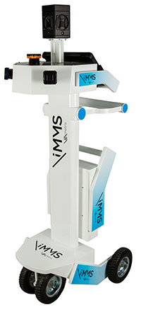
The iMS 3D indoor mapping system by Viametris uses an Ellipse-A by SBG for roll and pitch data.
SBG Systems will join Viametris in presenting a new 3D indoor scanning system at the INTERGEO trade show, which will be held Sept. 15-17 in Stuttgart, Germany.
The iMS 3D is a mobile 3D indoor scanner generating continuous point clouds. For this brand-new model of indoor mobile mapping system, or iMMS, Viametris chose SBG Systems’ miniature Attitude and Heading Reference Sensor (AHRS), the Ellipse-A. The iMS 3D is easier to transport, install and set up than previous iMMS. The iMS 3D also integrates new sensors, including the Ellipse-A from SBG Systems.
Based on the SLAM technology, the iMS 3D is equipped with three lidar profilers, each taking 40,000 points per second. The main lidar provides the horizontal profile, which also contributes to the continuous calculation of the iMS 3D position in the building. Two lateral lidars give vertical profiles, including the ceiling. While the user walks, pushing the iMS 3D at normal speed, the 3D profile of the room appears on the screen, since the system records 3D measurements of the same room. Easy to manipulate, one person is enough to survey every corner of the building with the iMS 3D.
During the survey, the 360-degree camera takes a spherical picture every two meters for a full documentation of the building. This solution makes indoor survey 10 times quicker than traditional methods usually using distance meters, Viametris said, adding that the iMS 3D delivers a combination of point density, acquisition speed and accuracy suitable for the building trade industry.
At the office, the user accesses a centimeter-level accuracy 3D survey as a point cloud and pictures by using the Viametris processing and browsing software. The user can import the point cloud in CAD software (Autodesk Revit, AutoCAD, MicroStation, Rhino, etc.) to easily produce 2D maps or 3D models. The point cloud can be colorized with the colors of the pictures taken during the survey, which greatly improves the environment understanding. Additionally, the user has access to contextual 360-degree pictures, making objects such as radiators, extinguishers or lights simple to distinguish and locate.
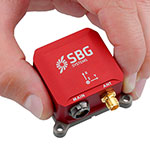
Ellipse-A.
Already integrated in other Viametris ultraportable technologies, the Ellipse-A has been chosen for this new generation of indoor mobile mapping system, or iMMS. “We integrated an Ellipse-A in our 2D system and were very happy with the results. It was obvious to us that the Ellipse-A will be part of our new iMMS,” said Jérôme Ninot, president of Viametris. The Ellipse-A is used to correct the horizontal profile. While the user is pushing the iMS 3D through the rooms, unevenness, slopes and ramps, cables or door thresholds can cause noise in the point cloud. The Ellipse-A keeps the point cloud clean by correcting the horizontal lidar data frames used to build the trajectory.
The Ellipse-A AHRS provides roll and pitch data accurate to 0.2° at 200 Hz. “The Ellipse sensors are much more efficient than the previous IG-500 product line,” said Mr. Ninot.
Keeping lidar and camera data precisely synchronized can be difficult because the camera focal time is susceptible to vary. In mobile scanning, even a slight latency might cause an offset. For example, the picture will not be located on the right place inside the point cloud. Viametris decided to connect the camera and the three lidars to the Ellipse-A to ensure a highly accurate and repeatable synchronization.
At INTERGEO 2015, the iMS 3D will be presented at stand # B4.049 and the ELLIPSE-A will be presented at stand # G4.079.
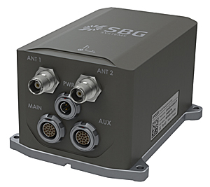
SBG Systems joins YellowScan to present a lightweight lidar with inertial and GPS for UAVs. The new product will be presented at the INTERGEO trade show in Stuttgart, held Sept. 15-17.
The YellowScan lidar is designed for fixed or rotary-wing UAVs, with an embedded Ellipse-E, a miniature inertial navigation system from SBG Systems, which helps obtaining a clear and accurate point cloud.
The UAV market is continuously growing, especially for professional applications like 3D surveying. Developed for such applications, YellowScan’s R&D team has worked closely with researchers and professionals in industries such as construction, surveying, mining and natural resources to create a comprehensive, high-performance and easy-to-use LiDAR.
Ellipse-E. The ready-to-use YellowScan is operational at up to 75 meters and delivers a highly dense point cloud accurate to 10/15 centimeter. The solution includes a lidar with a ±50 degree angle that measures 40,000 points per second, an Ellipse-E inertial navigation system coupled with a centimeter-level RTK GPS, an on-board computer, and an integrated battery.
The Ellipse-E miniature inertial navigation system by SBG Systems.
Once mounted on the drone, the user pushes the yellow button and YellowScan is ready to survey. LED lights give useful information on YellowScan state, for instance if the GPS is receiving RTK corrections or not. The user can launch the UAV and begin the survey. Once the task accomplished, a USB stick is used for downloading the data. An office software visualizes the point cloud in a few clicks, before opening it in an industry specific software like Terrasolid, AutoCAD or ESRI.
The YellowScan research and development team was searching for a high-performance, light and ITAR-free inertial navigation system for motion compensation and data georeferencing. They tested the Ellipse-E, the new miniature inertial navigation systems from SBG. Weighting 12 grams as an OEM version, it provides roll-and-pitch data accurate to 0.2 degree. The heading is accurate to 0.5° with only one antenna. Indeed, the heading computation relies on GPS and accelerometers data. This method is used when GPS positioning is widely available and punctuated by frequent accelerations, such as turns. The R&D team found the test results satisfying, and a point cloud highly clean. “We are very satisfied with this little Ellipse-E. It perfectly matches our technical needs, and we even gained 5 percent on the total weight of the YellowScan,” said Tristan Allouis, CTO at YellowScan.
Ellipse-E Coupled with External GPS Receiver. The Ellipse-E inertial navigation system is able to connect to any survey-grade GPS receiver and to fuse in real-time GPS position with inertial information. Ellipse-E maintains a reliable position even if GPS masks occur. In this application, the Ellipse-E is coupled with the AsterX-m OEM card from Septentrio, a receiver that uses GPS and GLONASS constellations and works with all types of RTK reference stations.
At INTERGEO, YellowScan will be in booth # F8.014, and SBG Systems will present the Ellipse-E at booth # G4.079.
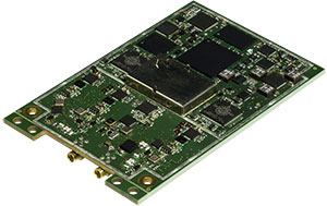
SBG Systems, a manufacturer of inertial navigation systems (INS), has selected the Septentrio AsteRx4 OEM GNSS receiver to equip its Apogee product line. The announcement was made during Ocean Business 2015, held April 14-16 in Southampton, England.
SBG Systems’ Apogee-D
“We are delighted that SBG Systems — a respected specialist in designing INS/GNSS — endorses our newly released GNSS receiver for its performance,” said, Laurent Le Thuaut, business development manager at Septentrio. “The SBG products are recognized amongst the preferred choice for accurate MEMS-based INS and we are extremely proud that our technology is included in their top of the line.”
Apogee is a new product line of high-accuracy inertial navigation systems based on robust and cost-effective MEMS technology. The INS/GNSS solution combines the latest generation of MEMS sensors and the OEM version of the AsteRx4, a newly introduced high-precision GNSS receiver from Septentrio. The Apogee series is especially suited for applications such as hydrography, mobile mapping and aerial survey where survey-grade positioning measurements are required.
AsteRx4 OEM
The AsteRx4 OEM is a multi-frequency and multi-constellation dual antenna receiver that incorporates the latest innovative GNSS tracking and positioning algorithms from Septentrio. The AsteRx4 is scalable to one centimeter and integrates the entire suite of GNSS+ algorithms proposed by Septentrio to maintain tracking during heavy vibration of machines. This assures position accuracy under difficult ionosphere conditions and mitigates or rejects intentional or unintentional interference with GNSS signals.
“The compact design and the practical and well-designed interface of the AsteRx4 allowed a seamless and an easy integration into our solutions” said Raphaël Siryani, chief marketing & sales officer of SBG Systems. “The AsteRx4 largely contributes to the robust and accurate heading as well as the reduced power consumption of the INS/GNSS Apogee products.”
Both the AsteRx4 OEM receiver and the Apogee INS/GNSS are on display at booth No. W40 (Septentrio) and booth E5c (SBG Systems) at Ocean Business.
SBG Systems has released the Apogee Series, its most accurate inertial navigation systems based on robust and cost-effective MEMS technology. The INS/GNSS integrates the latest generation of MEMS sensors and a tri-frequency GNSS receiver. Apogee achieves 0.008° in roll and pitch in real-time and 0.005° in post-processing. With two antennas, it delivers a robust and accurate heading.
Four models compose the Apogee line.
The Apogee-A provides only orientation data.
The Apogee-N additionally embeds a GNSS receiver; it is a compact solution with one antenna for land and aerial applications.
The Apogee-D embeds a dual-antenna GNSS receiver for accurate heading under low dynamics conditions.
The Apogee-E delivers navigation data when connected to an external GNSS receiver or to the SplitBox with integrated GNSS.
Mobile Mapping. Apogee can be precisely synchronized with LiDAR equipment because of a UTC time-stamping accurate to 1 microsecond. This integrated INS/GNSS provides optimal position in multipath environment or during GNSS outages, thanks to a tight GNSS integration and the continuous fusion of inertial and odometer data. To get the required positioning accuracy, Apogee supports RTK and Precise Point Positioning services (Omnistar, Terrastar, and more).
Aerial Mapping and Remote Sensing. With very low noise gyroscopes, low latency, and high resistance to vibrations, the Apogee allows aerial surveys by plane or helicopter. It provides real-time orientation and position data with direct fusion of inertial and GNSS information. Compact, lightweight and low power, the Apogee is easy to install, and has an embedded web interface for configuration.
Post-processing. Orientation and position data can be recorded in the Apogee data logger. At the office, the user imports data in the post-processing software. This tool gives access to several RTK networks and reference station offline data (such as VRS and CORS.) Additionally, it enhances orientation and position accuracy by a complete “backward/forward” calculation.
“SBG Systems manufactures inertial systems from the concept to the production. The Apogee benefits from our high level of expertise in integrated design, IMU calibration, testing, and filtering,” said Alexis Guinamard, CTO of SBG Systems.
All models are available for order. Below is a promotional video with more information.
 SBG Systems will demonstrate Qinertia, its in-house next-generation INS/GNSS post-processing software, at the Intergeo trade show, which takes place Sept. 26-28 in Berlin.