Septentrio has released Open Service Navigation Message Authentication (OSNMA) functionality on its mosaic GNSS receiver modules. OSNMA offers end-to-end authentication on Galileo’s civilian signals, protecting receivers from OSNMA attacks.
Spoofing is a malicious form of radio interference, where faulty positioning information is sent to a receiver. For the last two years Septentrio has been working closely with the European Space Agency (ESA) during the test phases of OSNMA deployment. The know-how gained during this period is what allowed Septentrio to be one of the first to market with this advanced security feature.
OSNMA’s anti-spoofing capability complements Septentrio’s Advanced Interference Mitigation technology, AIM+, and further strengthens the overall security of Septentrio GNSS receivers, making them suitable for assured PNT solutions as well as critical infrastructure, such as 5G network synchronization.
“We are excited to start offering the OSNMA anti-spoofing technology in our industrial GNSS receivers. Our close collaboration with ESA enabled us to get the expertise needed to implement and validate this functionality in a timely manner,” said François Freulon, head of Product Management at Septentrio. “The addition of OSNMA to Septentrio’s already strong anti-jamming and anti-spoofing technology takes our receivers to a new level as the market leader of resilient positioning and timing solutions for industrial applications and critical infrastructure.”
OSNMA is now supported by the complete mosaic receiver family including GNSS RTK positioning modules, timing modules and heading receiver modules. It will also be rolled out on Septentrio’s latest generation of OEM receiver boards, AsteRx-m3, and subsequently on the ruggedized boxed receivers. Read more here.
While connected cars provide wonderful advantages, their integration with cloud connectivity come with a heightened risk for cyber attacks.
Commentary by Alexander Meisel
When it comes to connected cars, automakers are innovating fast. Consumers are experiencing increasing amounts of futuristic features, be they passenger connectivity, automated speed regulation or autonomous driving capabilities.
However, these innovations and their integration with cloud connectivity come with a heightened risk for cyber attacks. A recent study conducted by U.K. self-driving hub organization Zenzic found that becoming cyber-resilient will be the biggest technical obstacle to successfully deploy self-driving cars on roads by 2030. This mountain will be a big one to surmount, and it’s only growing in size: The auto industry has seen a 94% year-over-year increase in hacks since 2016.
How can automakers prioritize security while keeping up with the demand for innovation in today’s connected cars?
Carmakers must consider security from day one
To make sure that security is built into the very foundations of a car, automakers must make it a priority from the first day of design. This focus is lacking amongst carmakers at the moment. In fact, 19% respondents to one survey said they don’t do enough security testing in the design phase, and only 28% said that they do a lot of the testing during the design stage.
Automakers can use design principles to build in security from the outset. For example, the principle of complete mediation allows for enhanced security as it ensures that a software stem “requires access checks to an object each time a subject requests access.” This means that attackers are only invited to exploit a system on one single occasion due to checks on subjects’ permissions.
Carmakers can also ensure that they are not sacrificing security by considering its importance when purchasing components from separate suppliers. These components must be specific enough to enable security in the system, but generic enough to allow for innovation.
Automakers must make cybersecurity a priority from the first day of design.
Here, companies can leverage the software engineering principle of interface segregation. This means that a shrunken, clear interface should be supplied by the vendor, so that the customer only uses the methods that are of interest to them.
In turn, this allows systems to remain decoupled and thus easier to then build a rich interface on top of. However, carmakers will have to stay on top of the security of the part in the development phase, and ensure that dormant functions are not abused by at least logging their execution once somebody tries to call them out of context.
Developers and cybersecurity experts must become a core part of the team
Software development is relatively new territory for carmakers. Now, cybersecurity is a key component of building connected cars, and automakers need to embrace developers that have expertise in this area and make them part of the core team.
This cultural change must be championed by the business leaders to allow car security to advance alongside the innovative features that the industry is building. This can be done by implementing DevSecOps ideology into the team, in order to “build the mindset that everyone is responsible for security.”
Car development teams will likely need a group of cybersecurity experts who can educate the rest of the developers and are willing to participate in the development process in order to check and implement safe and secure functions. If a company doesn’t have this kind of expertise in-house, they can partner with an expert third-party to help them along this journey.
Innovation and security can complement each other
Cybersecurity doesn’t mean sacrificing feature innovation: developments are being made in the field of security too, such as biometric technologies that can be integrated into car design.
For example, Blackberry’s QNX technology “has built in concepts for hardware and software trust validation, hypervisor to maintain a separation between the safety critical and infotainment systems, and a core operating system which passes all the functional safety standards,” according to the company’s senior VP SVP, head of QNX, John Wall. Innovation need not suffer at the hands of security, and vice-versa.
Potential AV thieves would first look to use GPS data to disable or falsify a car’s GPS system, making it untraceable.
In addition, the world’s leading electric vehicle provider, Tesla, ensures security in its cutting-edge, connected cars by sending security updates to cars’ operating systems overnight, and even providing awards for hackers that manage to hack its cars.
Looking ahead to the possibilities of autonomous vehicles (AV) that can drive passengers without needing to have their owner inside, innovation in GPS will be necessary to ensure security and accountability of the car. Potential AV thieves would first look to use GPS data to disable or falsify a car’s GPS system, making it untraceable.
However, carmakers can make this impossible for hackers by not just logging the data in its raw form, but also combining it with other car data using cryptographic algorithms. This ensures that the GPS data remains traceable even after the hardware has been taken apart and sold on the auto-parts black market. In this way, the signature of the original data combined with the GPS position adds an additional layer of security.
Integrating security into connected car design is no simple feat, but it’s a necessary one for carmakers that want to ensure the safety of their passengers while on the roads. By using design principles, diversifying expertise within development teams, and understanding that security and innovation need not be a trade-off, they can do just that.
Alexander Meisel is an automotive cybersecurity engineer at intive. He has a computer networking diploma from Hochschule Furtwangen University, and he has served as a CTO and Development Team Director in previous companies. He has experience with venture capital, successful M&As, and product and technical marketing strategies. He is also a public speaker at technical conferences and trade shows.
By Alexander Meisel, automotive cybersecurity engineer at intive
Alexander Meisel
When it comes to connected cars, automakers are innovating fast. Consumers are experiencing increasing amounts of futuristic features, be they passenger connectivity, automated speed regulation, or autonomous driving capabilities.
However, these innovations and their integration with cloud connectivity come with a heightened risk for cyber attacks. A recent study conducted by U.K. self-driving hub organization, Zenzic, found that becoming cyber-resilient will be the biggest technical obstacle to successfully deploy self-driving cars on roads by 2030. This mountain will be a big one to surmount, and it’s only growing in size: The auto industry has seen a 94% year-over-year increase in hacks since 2016.
So, how can automakers prioritize security while keeping up with the demand for innovation in today’s connected cars?
Carmakers must consider security from day one
To make sure that security is built into the very foundations of a car, automakers must make it a priority from the first day of design. This focus is lacking amongst carmakers at the moment. In fact, 19% respondents to one survey said they don’t do enough security testing in the design phase, and only 28% said that they do a lot of the testing during the design stage.
Automakers can use design principles to build in security from the outset. For example, the principle of complete mediation allows for enhanced security as it ensures that a software stem “requires access checks to an object each time a subject requests access.” This means that attackers are only invited to exploit a system on one single occasion due to checks on subjects’ permissions.
Carmakers can also ensure that they are not sacrificing security by considering its importance when purchasing components from separate suppliers. These components must be specific enough to enable security in the system, but generic enough to allow for innovation.
Here, companies can leverage the software engineering principle of interface segregation. This means that a shrunken, clear interface should be supplied by the vendor, so that the customer only uses the methods that are of interest to them. In turn, this allows systems to remain decoupled and thus easier to then build a rich interface on top of. However, carmakers will have to stay on top of the security of the part in the development phase, and ensure that dormant functions are not abused by at least logging their execution once somebody tries to call them out of context.
Developers and cybersecurity experts must become a core part of the team
Software development is relatively new territory for carmakers. Now, cybersecurity is a key component of building connected cars, and automakers need to embrace developers that have expertise in this area and make them part of the core team.
This cultural change must be championed by the business leaders to allow car security to advance alongside the innovative features that the industry is building. This can be done by implementing DevSecOps ideology into the team, in order to “build the mindset that everyone is responsible for security.”
Car development teams will likely need a group of cybersecurity experts who can educate the rest of the developers and are willing to participate in the development process in order to check and implement safe and secure functions. If a company doesn’t have this kind of expertise in-house, they can partner with an expert third-party to help them along this journey.
Innovation and security can complement each other
Cybersecurity doesn’t mean sacrificing feature innovation: developments are being made in the field of security too, such as biometric technologies that can be integrated into car design.
For example, Blackberry’s QNX technology “has built in concepts for hardware and software trust validation, hypervisor to maintain a separation between the safety critical and infotainment systems, and a core operating system which passes all the functional safety standards,” according to the company’s senior VP SVP, head of QNX, John Wall. Innovation need not suffer at the hands of security, and vice-versa.
In addition, the world’s leading electric vehicle provider, Tesla, ensures security in its cutting-edge, connected cars by sending security updates to cars’ operating systems overnight, and even providing awards for hackers that manage to hack its cars.
Looking ahead to the possibilities of autonomous vehicles (AV) that can drive passengers without needing to have their owner inside, innovation in GPS will be necessary to ensure security and accountability of the car. Potential AV thieves would first look to use GPS data to disable or falsify a car’s GPS system, making it untraceable.
However, carmakers can make this impossible for hackers by not just logging the data in its raw form, but also combining it with other car data using cryptographic algorithms. This ensures that the GPS data remains traceable even after the hardware has been taken apart and sold on the auto-parts black market. In this way, the signature of the original data combined with the GPS position adds an additional layer of security.
Integrating security into connected car design is no simple feat, but it’s a necessary one for carmakers that want to ensure the safety of their passengers while on the roads. By using design principles, diversifying expertise within development teams, and understanding that security and innovation need not be a trade-off, they can do just that.
Alexander Meisel is an automotive cybersecurity engineer at intive. Alexander has a Computer Networking diploma from Hochschule Furtwangen University, and he has developed as a CTO and Development Team Director in previous companies. He has experience with venture capital, successful M&As, product and technical marketing strategies. Meisel is also a public speaker at technical conferences and trade shows.
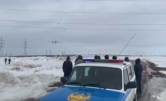
Terra Drone group company KazUAV has helped Nur-Sultan police to use drones to patrol and monitor illegal border movement and slow the spread of coronavirus in Kazakhstan
KazUAV, Kazakhstan drone service provider and a member of Japan-based Terra Drone Corporation, has been working at the frontlines to keep communities safe amid the COVID-19 pandemic outbreak.
Providing direct support to the operational headquarters set up to prevent the spread of coronavirus in Kazakhstan, KazUAV has been helping the Nur-Sultan Police Department to patrol the borders of the locked-down capital city with drones, ensuring “contactless” surveillance and fast-paced operations.
Nur-Sultan is the capital city of Kazakhstan.
The Central Asian nation closed its borders and locked down its main cities, including Nur-Sultan, after confirming the first coronavirus case on March 16. The oil-rich country that borders Russia and China also announced a state of emergency, set to last until April 15, adopting tough measures to combat the pandemic.
Some of the guidelines put forth by the Kazakh authorities include country-wide travel restrictions, suspension of public gatherings, and implementation of stringent sanitation and anti-epidemic measures.
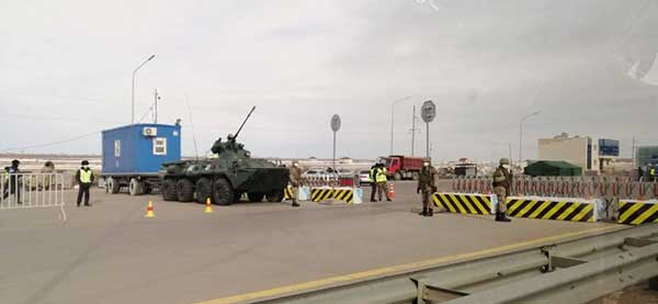
A checkpoint on the border of Nur-Sultan. (Photo: Terra Drone)
All entrances and exits from Nur-Sultan have been completely blocked as part of these measures, mobilizing multiple law enforcement agencies of the Republic of Kazakhstan. Armored vehicles, barriers, and concrete blocks are being used to man the movement from the surrounding villages of Talapker, Karaotkel (Ilyinka), Koyandy, Kosshy and Zhibek-Zholy, on the Nur-Sultan-Petropavlovsk highway.
An additional post has been set up by the municipal government of the Akmola region in Shubary to ensure there are no cases of non-compliance by the Kazakh population.
KazUAV has been directly involved in the collection of information, operational monitoring, and coordination of actions of the Police Department and the Coronavirus Spread Prevention Operational Headquarters for all these areas.
A KazUAV drone takes off to monitor the borders of the Kazakh capital of Nur-Sultan. (Photo: Terra Drone)
Using drone-mounted cameras with both visible and infrared sensors, the KazUAV team has completed hundreds of flight hours, broadcasting all captured data, as well as the exact coordinates of objects of interest, directly to the operational headquarters command center. This has led to the authorities discovering multiple bypass roads and irregularities in the locked-down area – without which, the quarantine measures could not have proven effective.
When it comes to remote monitoring of vast areas, unmanned aerial vehicles are one of the best tools available to public safety agencies today. As a leading drone service provider in Kazakhstan, KazUAV not only gave Kazakh first responders access to cutting-edge drone technology, the company also assisted the enforcement agencies with the vast experience of its team of specialists, trained to operate day and night in the toughest of weather conditions.
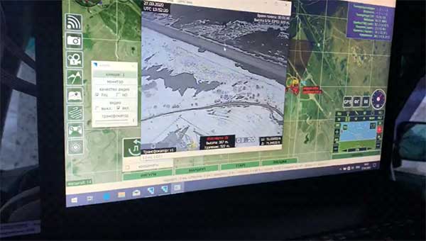
The UAV ground control station at the Coronavirus Spread Prevention Operational Headquarters in Nur-Sultan. (Photo: Terra Drone)
“As international experience has shown, restrictions introduced to prevent the spread of the coronavirus are the most effective measures to fight it,” said Dmitry Ivanov, development director, KazUAV. “Of course, it’s hard for everyone now; it is a challenging time for each one of us. But the call to stay home is more relevant than ever in the context of drones. We are familiar with carrying out critical tasks like monitoring floods or patrolling important events, but this was an emergency request which needed an immediate response.”
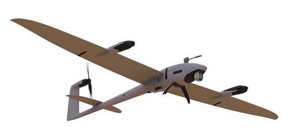
Two new small unmanned aerial systems (sUAS) are available to the U.S. government defense and security markets.
Auterion Government Solutions Inc. and Quantum-Systems GmbH have partnered to bring the Vector and Scorpion to market. The partnership brings together high-quality sUAS hardware with a secure, scalable, open source, operating system, Auterion OS.
Auterion OS is employed on sUAS from small multi-rotors to hybrid VTOL Group 2 air vehicles. The open-source operating system aligns with the Defense Department’s Group 1 UAS Architecture.
2-in-1 UAS
Vector and Scorpion form a 2-in-1 system kit. Scorpion is a tri-copter that can be used for dynamic urban environments and other mission sets that require a combination of maneuverability and hover to collect intelligence, surveillance and reconnaissance (ISR) data, as well as situation awareness information. If required, it comes with a tethering system to enable 24/7 operations.
By configuring the base fuselage with fixed wings and tail section, Scorpion transforms into Vector, an energy-efficient, fixed-wing VTOL for longer range, longer endurance ISR missions.
The Vector. (Photo: Quantum-Systems)
Command and control
Quantum-Systems uses a proprietary flight control stack as well as its qBase command and control software on the two air vehicles.
When the platforms are integrated with Auterion Enterprise PX4 software, Auterion Ground Station software, and the Auterion Hand-Held Ground Control Station (H-GCS) they form an open ecosystem that is aligned and integrated with DoD’s Group 1 UAS Architecture and requirements for a common Group 1 control system.
The integration enables these sUAS to be extensible, tailorable and interoperable for customers in both the U.S. defense and security markets.
“We are excited to be working with Quantum-Systems to bring forth a new, integrated, rucksack portable sUAS that we feel will transform the way our customers collect, process and disseminate ISR and Situation Awareness information, in all environments,” said David Sharpin, CEO of AGS.
“By setting up a U.S. entity, Quantum-Systems will move closer to the customer while working on setting up a large-scale U.S. production,” said Florian Seibel, CEO of Quantum-Systems.
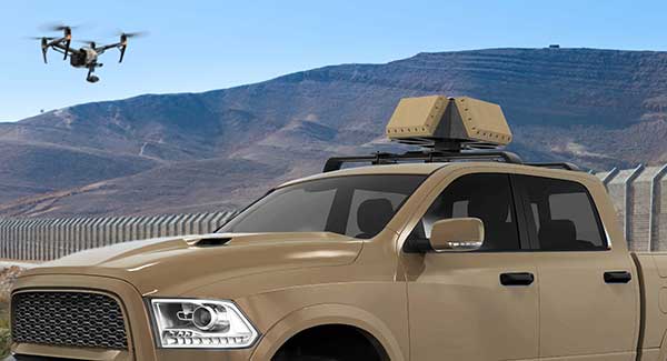
DroneShield has released a vehicle-mounted drone detection and defeat product, DroneSentry-X.
Lightweight at about 10 kilograms, it can be easily mounted on most vehicles. DroneShield expects the product to be of interest to military, law enforcement, security and VIP the markets. The product is suitable for both vehicle/convoy and fixed site installations. The product was developed in response to substantial customer interest, according to the company.
“Vehicle market for counterdrone protection is rapidly rising,” said DroneShield’s CEO Oleg Vornik. “In addition to catering for that segment, DroneSentry-X provides a more affordable detect-and-defeat solution for price-sensitive customers as an alternative to purchasing full-functionality DroneSentry product from us. DroneShield offers a complete suite of detection and defeat solutions to our customers, and this new product covers the customer need which we identified in our recent engagements.”
A new night map integration feature is available for all Concept3D maps. The toggle-on map overlay is designed to enhance campus safety and security by making it easy to find the best, well-lit routes and critical resources such as emergency phones.
The Concept3D interactive mapping platform is used by hundreds of major universities, colleges and schools, as well as convention centers, hospitals, resorts, retirement communities, data centers and businesses.
The night map feature offers all of these clients a way to provide their audiences with important safety and security information for visiting and navigating the campus at night.
The University of Denver, Boise State University, and Pacific Lutheran University are the first to integrate this feature into their Concept3D-powered interactive campus maps.
The night map of the campus of Boise State University. (Image: Concept3D)
Boise State University is using the new night map feature to highlight Public Safety Dispatch Centers, Emergency Blue Light and Refugee Phones and locations of automated external defibrillators (AEDs). Each item has a display box that further explain the exact location of the service and additional information.
Pacific Lutheran uses the night map to display campus AEDs, emergency telephones, and its safety building.
Colleges and universities that participate in federal Title IV student financial assistance programs must comply with the Clery Act, which requires annual security reporting, details and geographic information about crimes committed on campus and on public areas immediately adjacent to the campus, and timely warnings and emergency notifications, among other requirements.
Logan Scott, principal, LS Consulting. (Photo: Melanie Beus)
Logan Scott, principal at LS Consulting, is the inventor of an asymmetric navigation security paradigm for civil GPS signals that avoids the need for secure key storage in civil receivers and allows for widespread adoption in applications without physical security capabilities. Scott received the 2018 Signals Leadership Award from GPS World magazine. Read his acceptance speech below.
A crucial first step in developing resilient responses is to recognize that there is a problem so you can isolate it. Otherwise, an overly trusted element can contaminate the solution.
I am honored to accept this award from GPS World and our sponsors tonight. It has been a long journey from my initial vision of how civil signals might be authenticated to where we are now, with a draft Chimera signal specification nearing readiness for review.
I’d like to thank the Air Force Research Laboratory for sponsoring these efforts, and I would also like to acknowledge the outstanding efforts of the entire signals working group without whom this milestone would not have been reached: Captain Katie Carroll, Jon Anderson, Joanna Hinks and Nate DeVilbiss who brought me in on the project; Joe Rushanan and Jim Gillis who taught me so much about cryptography; Renee Yazdi and Brady O’Hanlon who pushed for no compromises. Working with this team has been one of the highlights of my professional career.
We have a solid design that fully realizes the benefits of chip-level binding with both fast and slow authentication capabilities. Chimera can offer security benefits far beyond the security theater of data message signing only. Moreover, it is a first step towards proving location.
Moving forward, the challenge I offer to you all is this: how can we establish the integrity and truthfulness of position and time reports both locally and remotely? How can we prove location, not only to ourselves but also to remotely located entities? In a world of autonomous vehicles, geofenced capabilities and information access, and an insecure supply chain, it is not enough to say that “I saw it on the C/A code.”
Complementary and overlapping techniques are essential in establishing the veracity of any claims. In support of this, we can and must provide assured spectrum protections for all GNSS systems.
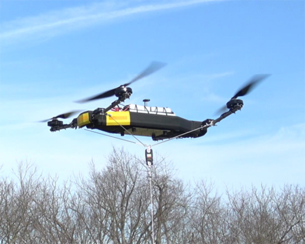
Mobile Recon Systems is offering an unmanned aerial vehicle that can lift more than its own weight.
At 78 pounds, the Dauntless multi-rotor UAV has lifted an additional payload of 100 pounds as a tethered quadcopter, the company said. It is designed to lift more than 200 pounds as an octocopter, with a generator-powered flight time of several hours.
Photo: Mobile Recon Systems
“Drones have proven to be great for videography. But uses beyond that have been limited by low lift capacity, limited flight time and narrow functional capability,” said Mobile Recon Systems founder Mike Dowell. “With the Dauntless, that is no longer the case.”
Not only can the Dauntless carry up to 160 pounds of supplies in a climate-controlled transport box, it is a multi-functional platform. It can be outfitted with sensors, radiation detectors, radar, weather stations, multi-spectral, thermal and infrared cameras, and other devices. It can perform eight or more different functions at once. Plus, users can easily swap or combine devices to meet their needs.
Those capabilities enable this model to deliver high value services previously out of reach for UAVs, the company said.
“The Dauntless is ideal for border and perimeter security, as well as natural disaster response, medical emergency first response, routine inspections and aerial analysis, and mapping,” Dowell said. “With its lift capacity, it can carry high-end lidar and cameras, as well as supplies. Our flexible platform offers a myriad of possibilities.”
To illustrate, the Dauntless can carry an MSOP and four multi-axis gimbals, mounted on top and bottom, to accommodate optical, thermal and multispectral cameras, including a RED Epic. high-end digital camera. These can simultaneously capture multiple types of images from below, front, overhead, right and left of the flying platform.
The Dauntless has a full 3K (military-grade) carbon-fiber body and titanium and aircraft aluminum frame. The propellers are carbon fiber, and are safely surrounded by the body. It is waterproof and sandproof.
As precision guidance, autonomous operations, high-definition geocoded images and high-volume data processing all improve, drone use will continue to increase. OEM receiver manufacturers, sensor suppliers and data-handling companies play key roles in development, and stand to profit thereby.
In particular, use of drones is growing in land management, construction, mining, and farming. An open-pit mine operation can be supported through detailed drone inspection producing high-resolution images. Processed images and data enable keeping tabs on inventory, site changes over time, identifying best areas for further extraction, and monitoring and managing vehicle movement. These tasks required huge amounts of time in the past. Drone overflight and processing tools condense all the effort as well as producing enhanced results to enable faster and clearer decision-making.
What is the biggest challenge for the UAV industry? (Source: GPS World 2018 State of the Industry survey)
Defense. Surveillance and reconnaissance are probably the biggest military drone applications. Carrying payloads that include color video cameras and infrared night vision cameras, more than 19,000 drones are now in the arsenal of the U.S. Army, Air Force, Marines and Special Ops, and more have gone to other nations’ militaries.
Flying at relatively low altitude, with somewhat limited range and powered by a single quiet electric motor, these drones have become essential in gathering forward-situation intelligence.
Other UAV craft provide higher altitude, longer-duration surveillance and reconnaissance over wider range: up to 20 hours, up to 15,000 feet, more than 60 miles afield. Civilian versions of these craft are in development.
Delivery. Respondents to our survey thought delivery will be a breakthrough application for drones. Amazon has several trials running globably. National civil aviation authorities need to move forward with plans to integrate drones into civilian airspace for this initiative to graduate to full-scale operations and achieve their objective of 30 minutes from order to delivery.
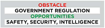
What is the killer app for drones? What professional UAV market sector will most powerfully drive adoption and influence new regulations for unmanned aerial vehicles? (Source: GPS World 2018 State of the Industry survey)
Precision Agriculture. One of the most significant applications which seems to be missing from survey responses is agriculture. Both quadcopters and hybrid fixed-wing/copter drones are in widespread use to capture image data overflying crops, and then process the data and build crop analytics. Graphic results point to how crops can be managed to increase yield.
Making this work is a combination of sensor payloads gathering visual, video, lidar, thermal and hyperspectral data; the secret sauce lies in how the data is processed and presented to farmers. Emphasis is placed on exactly how “green” crops appear when inspected by the various sensors. A number of companies offer services for farmers to optimize crop management.
All these areas are show significant drone growth. Let’s not forget facility, transmission line and pipeline inspection — tasks where drones excel at increasing efficiency and decreasing costs.
For more results from the 2018 State of the GNSS Industry, see this page.
Tony Murfin is a GNSS aerospace consultant with several decades experience at leading companies in the GPS/aviation and OEM sectors.
Deployed service members may have to ditch their fitness trackers in response to a new memo from Deputy Defense Secretary Patrick M. Shanahan prohibiting the use of GPS functions in deployed locations.
This includes physical fitness aids, applications in phones that track locations, and other devices and apps that pinpoint and track the location of individuals.
Pentagon spokesman Army Col. Robert Manning III announces the policy on geolocation devices at the Pentagon, Aug. 6, 2018. (Photo: DoD/Jim Garamone)
“Effective immediately, Defense Department personnel are prohibited from using geolocation features and functionality on government and nongovernment-issued devices, applications and services while in locations designated as operational areas,” Pentagon spokesman Army Col. Robert Manning III told Pentagon reporters on Aug. 6.
Deployed personnel are in “operational areas,” and commanders will make a determination on other areas where this policy may apply.
The market for these devices has exploded over the past few years, with many service members incorporating them into their workout routines. They use the devices and applications to track their pace, running routes, calories burned and more. These devices then store the information and upload it to central servers where it can be shared with third parties. That information can present enemies with information on military operations.
Using GPS Devices Pose Risk
Photo: Fitbit
“The rapidly evolving market of devices, applications and services with geolocation capabilities presents a significant risk to the Department of Defense personnel on and off duty, and to our military operations globally,” Manning said.
The GPS capabilities can expose personal information, locations, routines and numbers of DoD personnel. Their use in overseas locations “potentially create unintended security consequences and increased risk to the joint force and mission,” Manning said.
Personal phones and other portable devices also contain apps that rely on GPS technology, and they will be affected. Commanders will be responsible for implementing the policy, and they will be allowed to make exceptions only after conducting a thorough risk assessment.
Security is at the heart of this guidance. DoD seeking a balanced way that allows for legitimate official and personal uses of geolocation technology that does not impact security.
Manning said the department will continue to study the risk associated with these devices and change the policy as needed.
GPS World magazine recently conducted the 2018 State of the Industry survey, an online polling of the GNSS community. It has become an annual feature, probing for the technical and business challenges that are drawing attention this year, how executives, managers and product developers are driving business in today’s economy, what issues they are concerned about, and — always — what solutions hold the most promise for positioning, navigation and timing (PNT) in challenged and indoor environments, regardless of which technology provides them?
This column reports on the answers provided by those who identified themselves as working in the Defense, Security and Government (DSG) sector of the GNSS/PNT industry, and speculates on the insights that can be drawn from the answers.
Among all who took the survey, 18 percent said they worked in Defense, Security and Government, the second largest group among eight industry sectors, following only Survey and High Precision in size. Of the DSG group members, 82 percent were based in the United States, 6 percent each in Europe and Asia-other-than-Russia-China-and-Japan, and 4 percent from Latin America. Slightly more than half of them worked in companies of more than 500 people.
Queried as to job title, they answered as follows:
Owner/president/co-owner/CEO: 8 percent
Vice president, CTO, COO, CFO or similar: 6 percent
General Manager: 2 percent
Product or program manager: 10 percent
Researcher: 12 percent
Engineer: 44 percent, the largest group
and Other: 18percent, with this last category encompassing consultants, cartographers, a security architect systems engineer, and more.
Each sector group taking the survey answered two questions specific to their sector, while also responding to a variety of economic and systemic questions for the industry as a whole. In the DSG group, the specific questions were:
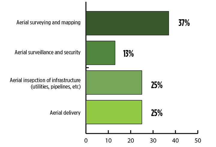
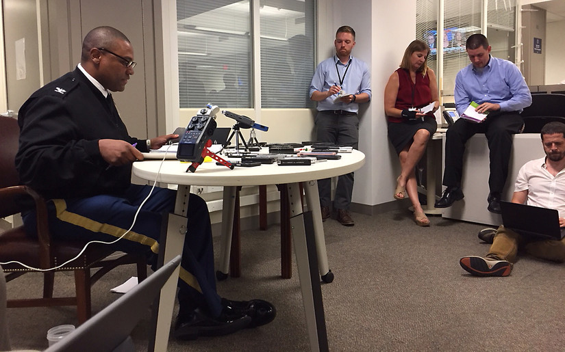
How vulnerable is GPS/GNSS in defense/security/critical government applications, that is, M-code or similar, to disruption by jamming, whether intentional or unintentional?
And:
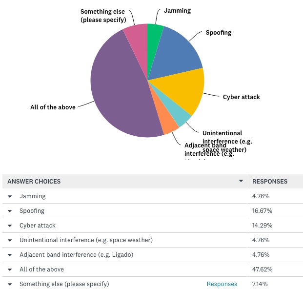
What is the greatest threat to GNSS over the next three years?
The answers to vulnerability appear here:
Source: GPS World 2018 State of the Industry survey
And the answers to threat here:
Source: GPS World 2018 State of the Industry survey
Perhaps we erred in offering an “All of the above” answer, as nearly half of respondents selcted that option. This shows a generalized awareness (and fear) of threats, but lacks the capability to then prioritize those threats.
Delving a little further into the responses from the DSG sector, when asked “What technology will win fully enable seamless outdoor/indoor navigation, in combination with GNSS,” they answered:
Assisted GNSS 8.57 percent
Assisted GNSS plus any ONE of the six other answers (Cell-tower triangulation, Proximity beacons, Radio frequency pattern-matching, Sensor-based dead reckoning, Terrestrial ranging system,Wi-Fi 22.86 percent
And the winner: Assisted GNSS plus MORE THAN ONE of the six alternatives 34.29 percent
With Don’t Know, 17.14 percent, and Other, 8.57 percent.
More than any other solution an integration of at least three sensors, in the opinion of the plurality, will be necessary for ubiquitous positioning and navigation.
First choice for a GNSS back-up? The leading answer was eLoran, at 25.71 percent, followed by Low-Earth orbit satellite constellations, 22.86 percent, and Sensor-based dead reckoning, 17.14 percent.
How much effort are you devoting to mitigation of GNSS jamming and/or spoofing?
This is the leading concern of out research and development effort 40 percent
This is an important concern for our R&D, but not the dominant one 20 percent
This is one among many factors we consider; no particular importance above others 17.14 percent
And very surprisingly: We are not focusing on jamming/spoofing mitigation at all at this time 22.86 percent
Finally, describe the market for GNSS products/services in the Defense, Security and Government PNT industry sector as of today.
Very healthy; strong growth 25.71 percent
Relatively healthy; moderate growth 48.57 percent
Flat 22.86 percent
Slightly down 2.86 percent
For more results from the 2018 State of the GNSS Industry, see this page.