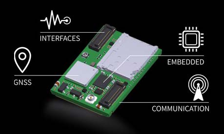
OriginGPS has chosen Gemalto’s Cinterion LTE-M wireless module to build its latest miniature OriginIoT system. Gemalto, a digital security company, designed the module for low-power applications requiring high security.
OriginIoT systems are generic cellular internet of things (IoT) systems that simplify IoT product development and slash development resources.
The systems include communication hardware, a GNSS module, embedded software and a novel interface to OriginIoT add-ons that accommodate multiple sensors and other peripheral devices.
OriginGPS signal-to-noise technology is leveraged to deliver superior GNSS and cellular matching, facilitating excellent performance in noisy environments, while the OriginSmart software enables cloud-based programming, relieving developers from writing embedded code.
The OriginIoT LTE-M system (ORG2101) has a 15 percent smaller footprint than the previous 2G and 3G models, and will be pre-certified with selected operators.
The low-power, wide-area Cinterion LTE-M module supports more than 10 frequency bands from a single hardware device, eliminating the need for multiple variants. The module protocols can run on the same hardware, thus providing a future-proof path for additional OriginIoT models.
“To save resources and stay competitive, such easy to develop low power solutions are essential for today’s IoT products,” said Andreas Haegele, senior vice president of IoT products for Gemalto. “We are glad to see that OriginGPS is expanding the market by offering accessible, affordable IoT products that are backed by Gemalto reliability and high quality,”
“We designed the OriginIoT LTE-M system to address market pains, and so our new offering includes low power consumption, superb GNSS/cellular matching, interfaces to multiple connectors, and software to enable developing from the convenience of the cloud,” said Robert van Tilburg, VP Global Sales and Business Development of OriginGPS. “These features serve to simplify and shorten IoT projects. Gemalto’s Cinterion IoT module enables OriginGPS products to retain their world’s smallest footprint, while enhancing their security and extending end-product life.”
OriginGPS will be showcasing its GNSS modules and OriginIoT systems at Embedded World, Feb. 27 – Mar. 1, in Hall 3, Booth 121.
AeroScope addresses safety, security and privacy concerns while protecting drone pilots
DJI has unveiled AeroScope, its new solution to identify and monitor airborne drones with existing technology that can address safety, security and privacy concerns.
AeroScope uses the existing communications link between a drone and its remote controller to broadcast identification information such as a registration or serial number, as well as basic telemetry, including location, altitude, speed and direction.
Police, security agencies, aviation authorities and other authorized parties can use an AeroScope receiver to monitor, analyze and act on that information. AeroScope has been installed at two international airports since April, and is continuing to test and evaluate its performance in other operational environments.
“As drones have become an everyday tool for professional and personal use, authorities want to be sure they can identify who is flying near sensitive locations or in ways that raise serious concerns,” said Brendan Schulman, DJI’s vice president for policy and legal affairs. “DJI AeroScope addresses that need for accountability with technology that is simple, reliable and affordable — and is available for deployment now.”
DJI demonstrated the system Oct. 12 in Brussels, Belgium, showing how an AeroScope receiver can immediately sense a drone as it powers on, then plot its location on a map while displaying a registration number. That number functions as the equivalent of a drone license plate, and authorities can use it to determine the registered owner of a drone that raises concerns.
In March 2017, in response to growing calls by governments worldwide for remote identification solutions, DJI released a white paper describing the benefits of such an approach to electronic identification for drones.
AeroScope works with all current models of DJI drones, which analysts estimate comprise more than two-thirds of the global civilian drone market. Since AeroScope transmits on a DJI drone’s existing communications link, it does not require new on-board equipment or modifications, or require extra steps or costs to be incurred by drone operators. Other drone manufacturers can configure their existing and future drones to transmit identification information in the same way.
Because AeroScope relies on drones directly broadcasting their information to local receivers, not on transmitting data to an internet-based service, it ensures most drone flights will not be automatically recorded in government databases, protecting the privacy interests of people and businesses that use drones. This approach also avoids substantial costs and complexities that would be involved in creating such databases and connecting drones to network systems.
This system is consistent with DJI’s problem-solving approach to drone regulation, which aims to strike a reasonable balance between authorities’ need to identify drones that raise concerns and drone pilots’ right to fly without pervasive surveillance.
DJI has led the industry with safety and security advances such as geofencing and sense-and-avoid technology, and believes the rapid pace of innovation provides the best means to address new policy concerns.
Drone identification settings will be included in DJI’s initial drone software to allow customers to choose the content of their own drone’s identification broadcast to match local expectations both before and after identification regulations are implemented in different jurisdictions.
To protect customers’ privacy, the AeroScope system will not automatically transmit any personally identifiable information until regulations or policies in the pilot’s jurisdiction require it.
“The rapid adoption of drones has created new concerns about safety, security and privacy, but those must be balanced against the incredible benefits that drones have already brought to society,” said Schulman. “Electronic drone identification, thoughtfully implemented, can help solve policy challenges, head off restrictive regulations, and provide accountability without being expensive or intrusive for drone pilots. DJI is proud to develop solutions that can help distribute drone benefits widely while also helping authorities keep the skies safe.”
DJI has launched a new Local Data Mode that stops internet traffic to and from its DJI Pilot app, providing enhanced data privacy assurances for sensitive government and enterprise customers.
Local Data Mode will be available in the next update on the DJI Pilot app on CrystalSky and for select Android tablets.
When an operator activates Local Data Mode, the app will stop sending or receiving any data over the internet. This adds an additional layer of security for operators of flights involving critical infrastructure, governmental projects or other sensitive missions.
“We are creating Local Data Mode to address the needs of our enterprise customers, including public and private organizations that are using DJI technology to perform sensitive operations around the world,” said Brendan Schulman, DJI’s vice p resident of policy and legal affairs. “DJI is committed to protecting the privacy of its customers’ photos, videos and flight logs. Local Data Mode will provide added assurances for customers with heightened data security needs.”
Since Local Data Mode blocks all internet data, the DJI Pilot app will not be able to detect the location of the user or show map and geofencing information such as No Fly Zones and temporary flight restrictions, nor will it notify drone operators of firmware updates.
Telemetry data on flight logs such as altitude, distance or speed will remain stored on the aircraft even if the user deactivates Local Data Mode.
Whether Local Data Mode is activated or not, photos and videos captured by the user are always stored on the drone’s SD card and are only shared if the user chooses to upload them online to the SkyPixel community, social media or other websites.
When using Local Data Mode, drone operators are reminded that they are solely responsible for the safety of their flight operation and that they understand that features that may enhance and support the safety of their operations, but that rely on internet connectivity, are no longer available.
Drone operators can enable Local Data Mode by opening the DJI Pilot app, clicking on “Activate LDM Mode” and entering a password which will be required to deactivate Local Data Mode when they decide to go online again.
New drones will still have to be activated first by logging into the user’s DJI account with an email and a password. To ensure the drone has the latest firmware, users can download and update it while they have internet connectivity before re-activating Local Data Mode.
The Local Data Mode feature may not be available in locations where an internet connection is required or highly advisable due to local regulations.
The NTP (Network Time Protocol) Reflector is a fast, accurate NTP server. It features denial of service resilience, monitoring and notification functions.
Characteristics include 100 percent hardware NTP time-stamping for accuracy and high performance; NTP packet monitoring for DoS detection; bandwidth limiting and packet filtering for CPU protection; and alarming if NTP loading is above expected levels.
To help users better understand the advantages of Microsemi’s NTP Reflector and packet limiting/monitoring technology, the company explains the underlying technology and its security benefits in the new application note, available for download.
Key Characteristics
100 percent hardware NTP timestamping for accuracy and high performance
NTP Packet monitoring for DoS detection
Bandwidth limiting and packet filtering for CPU protection
Alarming if NTP loading is above expected levels.
The NTP Reflector is one of the many differentiating features of Microsemi’s new SyncServer S600 series network time servers.
The reflector is a real-time, hardware-based NTP packet identification and time-stamping engine uniquely designed to protect the SyncServer CPU from excessive network traffic denial of service attacks and notify the operator if NTP traffic is above expected levels.
The innovative technology enables extremely high-bandwidth, high-accuracy, high-reliability and security-hardened NTP operations.
This month, we bring you a guest column on the 33rd Space Symposium in Colorado Springs, Colorado. Robin Wrinn, a communications professional based in Atlanta, gives her perspective on the premier annual space event, held in early April. Among her findings: new players in space race, new capabilities afforded by 3D printing and virtual reality, and insights into the GPS III program from Lockheed Martin’s VP for navigation systems.
— Alan Cameron, editor
Blue Origin spacecraft.
A host of new entrepreneurial and government players entering the space sector created an underlying sense of excitement that a new “space race” has begun. Visitors attending the 33rd annual Space Symposium first encountered the imposing, reusable Blue Origin spacecraft displayed prominently in front of the Broadmoor Hotel Exhibit Hall. It seemed to symbolically punctuate a statement that the space industry landscape is changing — and putting long-experienced government players and government contract monopolies on notice.
Hosted by the Colorado Springs-based Space Foundation, this year’s Symposium featured more than 180 exhibitors, including 38 new international partners and space, government and defense officials from more than 30 countries. In addition to the United States, other notable space nations attending included China, Germany, South Korea, Japan, high-level members of Russia’s ROSCOSMOS, and for the first time, the European GNSS Agency (GSA).
Space Recognized as a Security Asset
A primary theme throughout the speaker lineup was development of missions and programs to shore up national cyber and space security. Japan, for example, had previously banned all military use of space assets, but according to Shuzo Takada, director general of Japan’s National Space Policy Secretariat, the country has established new laws in part due to growing threats from countries such as North Korea.
Europe also has joined the club of providers of navigation services and has formally acknowledged the need to defend its member countries against cyber threats. In a keynote session, EU Commissioner for Internal Market, Industry, Entrepreneurship and SMEs, Elżbieta Bieńkowska, the first European Commissioner to address the Space Symposium, noted that Galileo, Europe’s GNSS, went live last December. In 2016, six Galileo satellites were launched building on the six the year before. Today, 17 leading chipset companies, representing more than the 95% of global supply, all produce Galileo-compatible products.
Bieńkowska also outlined a three-point space strategy for Europe that incentivizes innovation, including investment in R& D projects, but also prompts Europe to officially view space as a security asset. “We for the first time recognize that space is a strategic asset and a central element of Europe’s strategic autonomy. Europe must ensure its own security,” she said.
In his conference remarks, U.S. Congressman Jim Bridenstine welcomed addition of Galileo’s capabilities to the global satellite infrastructure, noting that GPS capabilities make it as important to our way of life as the electrical power grid. (Indeed, GPS actually enables key capabilities of the power grid through its precise timing, although Bridenstine did not mention this aspect.)
“There are very strategic risks to our satellite systems and we need to make sure the GPS, GLONASS and Galileo signals provide back0up to one another and are supported in bilateral ways. “
New Private Investment Sparks Change in Costs and Bidding
The growing presence of private investment in the space economy was very notable at this year’s Symposium. Jeff Bezos’ Blue Origin is among several entrepreneurial companies — Elon Musk’s SpaceX (Space Exploration Technologies) and Richard Branson’s Virgin Galactic, to name two others — that are challenging the traditional drivers. These new players are upsetting the standard government agency inclination to prefer longstanding relationships over price. Now the bid price gaps are too big to ignore.
Case in point: SpaceX has twice now in two years won bids to launch GPS III satellites, with price as a major factor. According to a March 2017 U.S. Department of Defense press release, SpaceX will provide the Falcon 9 launch vehicle production, mission integration and launch operation for support of the GPS III mission. The contract awards break a nearly 10-year monopoly held by United Launch Alliance, a joint venture of Lockheed Martin Space Systems and Boeing Defense, Space & Security.
Previously, Claire Leon, launch enterprise director for the Air Force Space and Missile Systems Center had been quoted as saying the service views the entrance of competition as a good step that will help the government over time. “You’ll see a lot of innovation between multiple contractors to invest in the rocket systems for the United States,” she said.
Lockheed Martin Touts Digital Tapestry Savings
Collaborative Human Immersive Laboratory (CHIL).
During the Symposium, Lockheed Martin Space Systems invited attending media to tour its expansive Littleton, Colo. campus where it is assembling and testing both the next-generation GPS III satellite constellation and the Orion spacecraft. Lockheed Martin is the prime contractor on the GPS III program and is under contract the U.S. Air Force to build eight position, navigation and timing satellites. The contract includes options for up to four more vehicles. In September 2016, the Air Force announced it had exercised the option for Lockheed Martin to build the ninth and tenth satellites, which will include additional hosted payloads to increase accuracy.
Throughout the tour, Lockheed Martin’s hosts emphasized the company’s cost and time efficiency innovations. We first saw the Collaborative Human Immersive Laboratory (CHIL), where Lockheed is using virtual reality (VR) technology to plan the design and manufacture of nearly all its aerospace components. In one of the largest VR laboratories of its kind, engineering teams review 3D models of product designs, tooling and facilities. Instead of paper, virtual prototyping enable Lockheed’s engineers to inspect holographs of the engineered designs, as well as become avatars to examine designs in virtual environments in full scale and in an immersive way. The lab also is used to conduct virtual dry runs of systems once products get to the shop floor.
Collaborative Human Immersive Laboratory (CHIL).
According to Darin Bolthouse, manager of the CHIL, Lockheed Martin began virtual prototyping in 2010 with an initial focus on the GPS III and the Orion space capsule programs. Now the company uses the CHIL across the enterprise for all programs. It also is looking for ways to shrink the large lab footprint with newer commercially available VR equipment to create more VR pods at other locations and a site-to-site VR environment network with other facilities, including Sunnyvale, Calif., Kennedy Space Center and Johnson Space Center.
Again, time and cost savings were emphasized with a primary narrative that “inserting virtual modeling and model-based engineering helps from the ground up.” Touted benefits included recouping an initial investment of $5 million per year since its construction in 2010 through cost avoidance in rooting out specific engineering problems in VR that otherwise would have been discovered on the shop floor. A specific example served up was using the CHIL to virtually redesign the top deck of the Orion spacecraft three times to work out human-machine ergonomic issues.
Parts made with a 3D printer.
In another leg of the tour, Lockheed Martin showcased how it uses 3D printing to make parts for both Orion and military satellites: tubing routings, bottles and attachments. This has reportedly reduced lead time to manufacture a single part from six months to 1.5 months, with assembly time reduced from 12 hours to just three. Another added benefit is accessibility and costs of replacement parts down the road. 3D printing provides the roadmap and means to recreate a part 20 years later even if Lockheed Martin or a sub-contractor should have ceased operation.
GPS III Vehicle Rundown
The highlight of the tour was Lockheed Martin’s top secret clean room, where the next-generation GPS III satellite constellation is being assembled and tested. The expansive space included areas for integrating the parts of each satellite vehicle, as well as environment testing chambers for acoustics and thermal vacuum, which simulate space conditions with extreme temperatures, including the near and far side of Earth solar temperatures. No phones, cameras or recorders were allowed, and even then parts of the satellite vehicles were draped off from visitors’ view.
3D printer.
Prominent placards gave the GPS III Program Production Status:
Space vehicle integration forecast completion – May 2017
Environmental testing to begin – May 2017
Available for launch – 2018
Vehicle 03
Navigation Payload forecast delivery – Spring 2017
Space vehicle integration – Fall 2017
Begin environmental testing – Early 2018
Available for launch – 2019
Vehicle 04
Navigation Payload forecast delivery – Fall 2017
Space vehicle integration – Early 018
Satellite Delays Resolved
According to Lockheed Martin spokesperson Chip Eschenfelder, who spoke with GPS World during the media tour, previously reported GPS III engineering delays related to the payload have been resolved.
Lockheed Martin’s GPS III clean room in Littleton, Colorado
Lockheed subcontractor Harris Corporation provides the critical mission data unit (MDU) and other components of the navigation payload, including atomic clock timing systems, radiation-hardened computers and powerful transmitters to deliver accurate, robust navigation signals for the GPS III constellation. Last year it was discovered that a ceramic capacitor had not been subjected to all the program’s required qualification tests. Once the issue was discovered, Harris deployed a dedicated team to complete the required tests by December 2016. The issue caused a delay of four months. The part was among the more than 28,000 used in the navigation payloads for the GPS III vehicles. The company announced in February 2016 that it plans to offer a fully digital navigation payload for the GPS III’s space vehicle 11 and beyond.
According to Harris Corp. spokesperson Ellen Mitchell, the company has so far delivered two full payloads to Lockheed Martin and has delivered some of the hardware for the third space vehicle.
Another potential GPS III delay presented itself in March 2017 when the U.S. Air Force opened a review of the propulsion systems used for Lockheed Martin’s GPS III and other military satellites, following a problem during an attempt to boost one into orbit. According to Eschenfelder, the review is a standard process and was out of an abundance of caution. Lockheed is“confident that this review will not delay the Air Force’s planned spring 2018 Initial Launch Capability (ILC).”
Further comments on the GPS III program came in a subsequent conversation I held with Mark Stewart, Lockheed Martin’s vice president for Navigation Systems:
Q: GPS III has extensive military applications. What differences will it bring to the civil, end-user experience as compared to today’s?
A: Millions of commercial and civilian users rely on GPS every day. GPS III begins a new era of improved Positioning, Navigation and Timing (PNT) performance for these civilian users in that it will be the first GPS satellite transmitting a new L1C civil signal designed to be compatible and interoperable with other international Global Navigation Satellite Systems (GNSS), like Galileo and QZSS. In the near future, civilian GPS receivers – like those found in smart phones — will be looking for L1C and compatible signals from satellites from multiple GNSS constellations, including GPS III. With more opportunities for GPS receivers to maintain “line-of-sight” L1C connections, civilian users will have much improved connectivity.
Q: What is the impact of the OCX/ground segment delay? Won’t that impact realizing GPS III’s full capabilities on time?
A: The first GPS III satellite, GPS III Space Vehicle 1 (GPS III SV01), was placed in storage on Feb. 27 and is now awaiting call up for launch from the Air Force. GPS III SV01 will need the Next Generation OCX Block 0 to launch. We are working closely with the Air Force and Raytheon to demonstrate GPS III SV01 operating on orbit as soon as possible. It is more appropriate for the U.S. Air Force and Raytheon to comment about OCX’s capabilities and what it will bring to the overall GPS III enterprise.
OCX Block 1 is the baseline program under development to command and control GPS III satellites. As a temporary gap-filler until OCX Block 1 is available, the Air Force placed Lockheed Martin under contract for “GPS III Contingency Operations” (COps), which will enable the current GPS Operational Control Segment (OCS) to checkout and operate GPS III satellites prior to the delivery of OCX Block 1. Lockheed Martin’s COps program successful completed a Critical Design Review in November 2016, on schedule for delivery in 2019.
Q: How do you see the future of GPS in a multi-constellation environment (considering that soon in addition to GPS and the Russian GLONASS, the European Galileo and the Chinese Baidoo will be fully operational)? And what does that mean for the civilian end-user?
A: Civilian multi-constellation users will significantly benefit from the new L1C signal, designed be compatible and interoperable with the Galileo E1 Open Service (OS) signal. In addition, GPS navigation messages include the GPS/GNSS-time offsets to enable a multi-constellation PNT solution.
Q: Galileo will be implementing a Commercial Service already in the first generation. Do you think that such a service could be implemented in the future on GPS?
A: Ultimately the capabilities of future GPS satellites will be determined by the Air Force. That said, Lockheed Martin’s GPS III was specifically designed to be flexible and modular so in the future the satellite could easily incorporate new missions if they are deemed necessary, and new technology as it becomes available.
Q: What were and are the technology challenges Lockheed Martin faced during the GPS-Ill development?
A: GPS III is the most powerful GPS satellite ever designed, with three times greater accuracy and up to eight times improved anti-jamming capability. That increased signal power comes from a revolutionary new navigation payload. Early in development our payload provider, Harris Corporation, had some design challenges. Those issues were eventually overcome and fully validated when GPS III SV01 successfully completed its Thermal Vacuum (TVAC) test in December 2015. We are excited to be bringing GPS III’s new capabilities to our warfighters soon.
Q: How do GPS III satellites compare with Galileo FOC satellite constellation? Achieve parity (Galileo 2 frequency, current GPS 1)? or leapfrogging over Galileo technology?
A: I cannot speak for Galileo’s capabilities but the U.S. Air Force’s Global Positioning System (GPS) has been the gold standard for PNT for more than 20 years. Lockheed Martin’s GPS experience includes more than 250 collective years of on-orbit operations for the 19 GPS IIR and IIR-M satellites that make up about 60 percent in today’s GPS constellation. With GPS III being the most powerful GPS satellite ever designed and built, I am confident GPS III will maintain that PNT gold standard ranking.
Q: There were clock anomalies in Galileo. What are you doing to avoid similar issues? Are GPS III clock’s different or the same?
A: GPS III Rubidium Atomic Frequency Standards (RAFS) have evolved from GPS IIR and IIR-M RAFS, which have collectively and reliably provided more than 250 years of on-orbit service, including significant time beyond their intended design lives. Our GPS III RAFS clocks undergo rigorous environmental qualification and life tests to assure performance over this next generation satellite’s 15-year design life. In addition, each GPS III SV includes multiple RAFS for redundancy. GPS III continually monitors the active RAFS to detect and mitigate clock anomalies. This is just one way that GPS III provides increased signal integrity for GPS users.
Galileo clocks utilize different suppliers than GPS III clocks. The GPS III clock supplier has produced reliable RAFS clocks for GPS satellites over the past several decades.
[end of Mark Stewart interview]
Ground Control
The GPS III satellite program is heavily dependent on the GPS Next Generation Operational Control System (GPS OCX), which according to government officials has experienced developmental issues and remains under General Accounting Office (GAO) scrutiny.
In assessing the implications, it’s important to note that OCX’s development is delivered in blocks, with Block 0 comprising the Launch and Checkout System required to take GPS III satellites into early orbit. Block 1 is built on Block 0 and will deliver the full OCX capability, allowing the Air Force to transition from its current GPS ground controls to the modernized and secure GPS OCX master control station.
According to the OCX prime contractor, Raytheon, all coding for Block 0 is complete and testing is wrapping up for delivery. Block 1 development is ongoing with the final iteration estimated to be completed in late 2018.
Findings in a recent GAO report are prompting examination of the reasons for the cost overruns and delays in military development programs. Meanwhile, the Air Force is looking at ways to modify the existing GPS control system to enable the operational use of the GPS III satellites until delivery of the OCX Block 1. Regardless, the Air Force may need to delay the launch of multiple GPS III satellites, according to the GAO.
Mr. Bezos, Mr. Musk, Mr. Branson … are you out there?
Spirent Communications plc, provider of mobile network, application, services and device-test solutions, is warning of the increased likelihood of disruptions this year to a wide variety of civil and military applications relying on GNSS.
The prediction of greater risk from hacking and location spoofing attacks by criminal, state-sponsored, and other adversaries is part of Spirent’s annual security forecast for 2017. The forecast also highlights the continued risk of distributed denial of service (DDoS) attacks on Internet of things (IoT) devices and industries, including health care and automotive, that Spirent believes are the prime targets for security threats in the near future.
In 2016, Spirent’s predictions led off with a prescient warning about the increased risk of cyber espionage, which has since been borne out, most notably by news reports of suspected activities by the Russian government to influence the 2016 U.S. presidential election.
Also as predicted, in 2016 threats from ransomware, malicious insiders and compromised IoT devices increased, as did attacks on industrial control systems. For example, FBI sources reported on CNN that losses attributed to ransomware in the U.S. were set to exceed $1 billion by the end of 2016. That number is expected to grow in 2017.
In addition to an increased likelihood of GNSS interference, Spirent’s annual security forecast for 2017 predicts an expansion of risks from:
More frequent DDoS attacks against IoT devices, as evidenced in the last quarter of 2016, when multiple major DDoS attacks surfaced worldwide. The most disruptive attack employed Mirai malware covertly installed on a large number of IoT devices. A number of high-profile websites such as Netflix, AirBnB, Twitter, GitHub and others were rendered inaccessible. Spirent believes that perpetrators will continue to innovate and find new methods for improving and broadening these type of attacks.
Threats to IoT security, which are increasing as everything that is connected becomes a potential attack vector, including embedded devices, mobile devices, consumer electronics, connected medical devices, industrial control systems, smart home devices, and more.
Threats to medical applications, networks, and devices in the health care industry, both the back-office systems on which these facilities run and the medical instruments that provide care to patients. A ransomware infection or data breach could adversely affect patient health and privacy.
Threats to connected vehicles by malicious attackers, as a greater number of attack vectors are inadvertently created that enable remotely gaining control of critical operational components of the vehicle, including engine, steering, and braking functions in addition to other vehicle systems that communicate through the relatively insecure CAN bus infrastructure.
“With the greater drive towards use of autonomous vehicles, which rely heavily on precision GPS positioning and timing, threats posed by signal spoofing, jamming, time tinkering, and more could result in serious disruptions and worse,” said Sameer Dixit, senior director of security consulting at Spirent. “The transportation industry is taking this very seriously and already looking at various ways to protect against these threats. Because of this, we see momentum towards improving GNSS security in 2017.”
According to an article in Defense One, Timothy Bennett, a science-and-technology program manager at the Department of Homeland Security, has already reported the use of GPS spoofing and jamming equipment by Mexican drug cartels along the border to interfere with the U.S. Customs and Border Protection agency’s use of drones to patrol the area. Unlike the larger drones designed to military specifications, the smaller drones used for this purpose are more vulnerable to these kinds of attacks.
Spirent’s global network of GPS interference detectors has recorded more than 15,000 interference events since it was deployed in 2015, including a surprisingly high number of unintentional events caused by various forms of interference in the GPS L1 frequency band. A significant number of these unintentional events, which often correlate with transmissions from nearby RF transmitters and telecom equipment, have the potential to interfere with GPS signal reception.
Dixon noted one bright spot on the horizon: the increasing awareness up and down the technology food chain of the importance of security in these systems, and the entry of large, experienced, and security-conscious players into the IoT arena.
Air Force Space Command began its 10th Schriever Wargame May 19 at Maxwell AFB, Montgomery, Ala.
The Schriever Wargame (SW 16), set in the year 2026, explores critical space issues and investigates the integration activities of multiple agencies associated with space systems and services.
The objectives of SW 16 center on identifying ways to increase the resilience of space that includes our intelligence community, civil, commercial and Allied partners; exploring how to provide optimized effects to the warfighter in support of coalition operations; and examining how to apply future capabilities to protect the space enterprise in a multi-domain conflict.
The Air Force announcement did not include specific mention of GPS jamming and spoofing, but these and related cyberthreats could reasonably be expected to appear in the pantheon of cyberspace competition.
The SW 16 scenario depicts a peer space and cyberspace competitor seeking to achieve strategic goals by exploiting those domains. Scenarios will focus on the European Command Area of Responsibility. They will also include a full spectrum of threats across diverse operating environments to challenge civilian and military leaders, planners and space system operators, as well as the capabilities they employ.
The Schriever Wargame team will conduct SW 16 on behalf of Air Force Space Command, headquartered in Colorado Springs, Colorado. Approximately 200 military and civilian experts from more than 27 commands and agencies around the country will participate in the Wargame.
U.S. commands and agencies participating in SW 2016 include: Air Force Space Command, Army Space and Missile Defense Command, Naval Fleet Cyber Command, the National Reconnaissance Office, Executive Agent for Space Staff, Air Combat Command, Office of the Secretary of Defense, U.S. European Command, U.S. Strategic Command, Defense Information Systems Agency, the Intelligence Community, National Aeronautics and Space Administration, Office of Homeland Security, Department of Transportation, Department of State and Department of Commerce.
Microsemi Corporation, a provider of semiconductor solutions differentiated by power, security, reliability and performance, today announced its SyncServer S6xx series of Network Time Protocol (NTP) servers.
The new SyncServers provide a highly secure, accurate and flexible timing and frequency platform for synchronizing network elements and mission-critical electronics systems in enterprise information technology (IT) applications such as Internet protocol telephony and physical security, and government instrumentation applications such as satellite communications and defense operational infrastructure.
“Microsemi’s new SyncServer series is a rock-solid enterprise level time server, interoperating easily with our Domain Time II software,” said Jeffry Dwight, president of Greyware Automation Products, the leading provider of time synchronization, management, and auditing software for Windows. “The new SyncServer raises the bar for accurate time synchronization with hardware-based time stamp support, which we found significantly reduced jitter and latency in time served, without losing accuracy. Installation was also much more flexible than any other GPS/GNSS unit we’ve tested. Anyone needing dependable high-quality NTP timestamps should consider Microsemi’s new SyncServer series.”
The new series features SyncServer S600, a security-hardened NTP time server with Microsemi’s NTP Reflector technology for robust security, accuracy and reliability of network time services, and the SyncServer S650, a highly versatile timing and frequency system with the company’s FlexPort technology for multiport, user definable output signal configuration.
The SyncServer S600 is designed for enterprise IT customers managing corporate networks in industries such as financial services and healthcare, while the SyncServer S650 is designed for electronics system engineers synchronizing mission-critical, system-level instruments.
“Robust security, system agility and flexibility of time services are essential for modern IT networks,” said Sri Purisai, vice president of timing and synchronization business, at Microsemi. “Our innovative SyncServer S6xx series timing platform makes significant advances in the security hardening of timing ports, as well as adaptability to various network topologies and flexibility of timing output configuration. This next-generation offering from Microsemi provides our customers a simple migration path to meet future requirements for faster, more agile and scalable network operations.”
According to the 2014 U.S. State of Cybercrime Survey, organizations use a gamut of security technologies to protect network operations. Time plays a vital role in determining the critical “when” of several key security technologies. Survey respondents cited intrusion detection (62 percent), log monitoring to identify intrusion attempts (49 percent) and security event analysis (40 percent) as technologies used for network protection. Without accurate time synchronization to UTC across the network, the effectiveness of these tools in securing the network becomes marginal.
SyncServer S600
Microsemi’s SyncServer S600 is a network time server with security-hardened NTP Reflector technology, supporting extremely high-capacity and ultra-accurate NTP server operations in a multiport, dedicated network time appliance. Easily integrated into existing, future and cloud network topologies, including software-defined networking (SDN), the SyncServer is designed for IT network administrators and architects who are heavily reliant upon server log files for network management.
SyncServer S600 comes with four 1 Gigabit Ethernet (GbE) local area network (LAN) ports, each port equipped with hardware time stamping, multiplying the network configuration possibilities. All ports are equipped with high-resolution hardware time stamping, and the S600 is NTP and precision time protocol (PTP) ready in a multiport PTP configuration.
A simple software update and license purchase/installation will be available in a future software release. Other benefits include interoperability, ease-of-use, extensive security choices and a modern web interface, Microsemi said.
Additional features:
NTP hardware time stamping standard, with nanosecond accuracy
NTP reflector technology for improved security, NTP throughput and accuracy
Comprehensive suite of security protocols
SyncServer S650
As a superset of Microsemi’s SyncServer S600, the SyncServer S650 provides all the features of the SyncServer S600, as well as additional offerings. Leveraging the company’s FlexPort timing technology, it delivers flexibility in precise time and stable frequency synchronization in a price competitive commercial off-the-shelf (COTS) solution.
FlexPort timing technology efficiently and cost-effectively adds innovative “any signal, any connector” technology through software configuration, eliminating the wasted space inherent with legacy-style fixed-signal modules with fixed-signal types.
Specially designed for system and instrumentation engineers in the electrical, system, metrology, communications and defense markets looking to easily output a variety of accurate and stable time and frequency signal types in a cost-effective manner, the device provides network-based timing features with software upgrades to completely security-harden the system.
The GPS referenced SyncServer S650 is built for modern electronic systems and networks that require synchronization performance adaptable to a wide range of applications. Microsemi’s FlexPort configurations eliminate the need for distribution chassis, saving time and costs, in addition to providing an easy-to-use system, Microsemi said. Other benefits include high accuracy and signal quality, as well as environmental design robustness.
In addition to the features of the SyncServer S600, the SyncServer S650 has:
Clock accuracy typically better than 10 nanoseconds to universal time
Standard timing I/O card that meets most popular timing output requirements, eliminating the need to purchase multiple plug-in modules
FlexPort technology option for any signal, any connector flexibility.
At this year’s Association of the United States Army (AUSA) Annual Meeting, Lockheed Martin unveiled a new capability that will allow users to detect and counter emerging threats from unmanned aerial systems (UAS). The solution, ICARUS, was designed to operate defensively in various threat environments. The AUSA meeting was held Oct. 12-14 in Washington, D.C.
“The U.S. government is seeing an increase in the use of commercially available UAS platforms for surveillance and weaponization,” said Deon Viergutz, vice president of Cyber Solutions for Lockheed Martin. “What Lockheed Martin has developed in ICARUS is a system that can detect, recognize and counteract these systems with pinpoint accuracy.”
Lockheed Martin’s Counter-UAS system has been field tested and demonstrated to several domestic and international customers over the past year. Those tests demonstrated the ability of ICARUS to identify and intercept commercially available unmanned aerial systems.
The development of the ICARUS software system draws on Lockheed Martin’s history of innovations in electronic warfare, cybersecurity and countermeasures associated with sophisticated threats. It was developed through Lockheed Martin internal investment and combines advanced cyber and cyber electromagnetic activity experience with sensor technology and non-kinetic techniques.
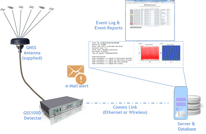
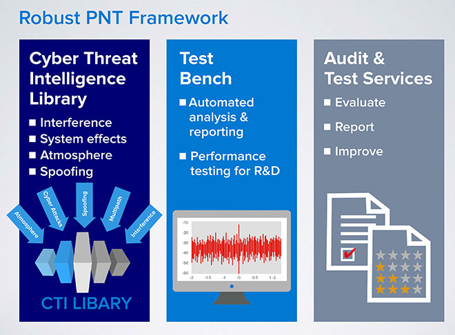
Spirent Communications has announced a Robust PNT Test Framework that evaluates GPS and GNSS security vulnerabilities for positioning, navigation and timing (PNT) systems.
Threats to GNSS and related PNT applications are more orchestrated and coordinated, with the motivation to disrupt or cause financial loss. The technology to disrupt GPS has also become much more accessible, resulting in GPS vulnerability gaining attention at hacker conventions.
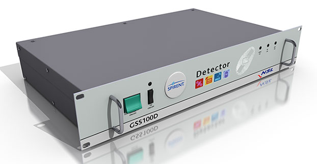
Spirent’s GSS100D Detector, developed in collaboration with Nottingham Scientific Ltd, enables detection, characterization and analysis of real GNSS threats.
The Robust PNT Test Framework will be used by technology, system and application developers where PNT is critical. Spirent’s framework enables threats to be detected in the field, taken into the lab and re-synthesized along with GPS and other GNSS signals. In addition, Spirent’s threat intelligence library of actual and typical threats provides a wide range of GNSS segment errors and spoofing attacks, as well as space weather and other vulnerabilities for preventive troubleshooting.
“Spirent wants to move beyond talking about the increase of GNSS vulnerabilities and offer a pragmatic approach to enable informed decision making when it comes to evaluating the impact of vulnerabilities,” said John Pottle, marketing director of Spirent’s Positioning Technology Division. “Through our Robust PNT Test Framework Spirent is pulling everything together to enable users to readily audit systems and take practical steps to improve resilience.”
With market share second only to Ericsson, TeleCommunication Systems Inc. (TCS) is investing in location-based services (LBS), particularly those used for indoor location.
One key investment was the July acquisition of Loctronix, a small Seattle-based provider of positioning systems for GNSS-challenged environments.
TCS senior vice president and commercial software group president Jay Whitehurst spoke exclusively to GPS World at CTIA Super Mobility 2015 in Las Vegas this week about the acquisition.
“We’ve been building out the (indoor location) technology, and we bought the assets of Loctronix and hired their CEO (Michael B. Mathews),” Whitehurst said. “They had a developed library and were at proof-of-concept almost ready to go to market and needed a vehicle to get it out there. We have 50 percent market share in E911, and in LBS we have 26 percent market share, relative to Ericsson’s 28 percent.”
Loctronix’s Mobile Explorer Platform is designed for mobile devices, and delivers high-accuracy positioning booth indoors and out.
The acquisition comes as TCS completes E911 interoperability testing with four public-safety equipment vendors, ahead of impending government regulation of E911 and with increasing public awareness about the need for emergency services that work with modern technology.
Beyond public safety and security, Whitehurst says there are “unlimited applications” for the company’s indoor location tools in the commercial sector.
From Mathews’ perspective, he made “the right choice” in selling his company. Mathews is now vice president of location technology at TCS.
“I found it was easy to be an evangelist, but scaling that into a commercial solution you could sell and make money on are two very different things. It’s easy to have vision, but you’ve got to have infrastructure and the scale of a company behind you to get it to happen,” he said, standing next to Whitehurst in the TCS booth. “We were able to fit into their infrastructure, and they’ve got a lot of tools we couldn’t wait to get our hands on.”
TCS plans to announce new geolocation tools based on the Loctronix assets in the fourth quarter. Without going into detail, Mathews described what’s coming as a “holistic solution” — then joked with Whitehurst that in his new role as a “tech guy” instead of CEO, “It’s not my problem.”
“The story we’re going to tell the next few months is pretty awesome,” Mathews said. “When we say location everywhere we mean location everywhere.”
Whitehurst presents VirtuMedix, a telemedicine platform using TCS’s LBS solutions
“In the healthcare market vertical, clinicians are licensed to practice in a state. So knowing when somebody is accessing a healthcare provider by a mobile device, we have to determine if they are in the state the clinician is licensed to practice. It’s an important usage of (location-based services).”
Dr. Todd Bacastow, PSU, talked with me about geointelligence in the broader business community. See the full interview below.
Time for a Revolution — or Evolution
In July at GEOINT 2015 I was talking with long-time colleague Dr. Todd Bacastow. Many of you may know him as the retired Army Lieutenant Colonel and Penn State professor heavily involved in the Geospatial Intelligence Certificate program and the lead for the GEOINT Massive Open Online Course (MOOC) series focused on GEOINT. He proposed a topic for my column that struck a nerve with me since I and others had danced around the potentially heretical issue — is it time to open and expand the GEOINT community to a larger audience?
As retired military officers, Todd and I share a common overarching loyalty and desire to do what we can to make life better and more survivable for our colleagues on active duty. GEOINT has certainly helped by providing detailed and timely actionable intelligence for those at the tip of the spear. However, can we do even better? Most assuredly yes!
The most advanced tip of the spear is our Special Operations community. Manycivilians picture Special Operations members as knuckle-dragging Rambos shooting up the countryside, but nothing could be further from the truth. In fact, they are without doubt the most intelligent, observant and capable people on our DOD team. They’ve learned over decades of experience that they can complete their missions and accomplish far more by winning the hearts and minds of individuals they deal with. Doing that requires hours, days and weeks of due diligence reviewing intelligence and any crumb of information that will make a difference.
Gone are the days of just looking at aerial photography. Now we have countless sources and types of imagery, analytics, tracking, social media, signals and human intelligence. Putting that complex slurry of information together into solid actionable intelligence is everyone’s goal, and the business community is no exception.
Looking around the GEOINT Expo, I saw countless three-letter agency reps, military and homeland security personnel. There were an equal number of defense contractors and related business personnel, but everything was focused on military/security applications. Other than Pitney Bowes showing MapInfo, primarily a business-focused GIS, there were few exhibitors showing technology not aimed at the traditional GEOINT community.
Our military and other first responders have tasks and responsibilities that are serious, complex and becoming more challenging. Limiting the talent pool and body of knowledge to only the narrow GEOINT community is not something we can afford to do. The creative talent found in the broader business community is too valuable to neglect.
Watch the video interview I shot at GEOINT 2015 with Bacastow and Dennis Bellafiore, Ph.D., both of Pennsylvania State University.
My chief concern is bringing the business community in with the understanding that this would be an open and sharing environment. My first real use of GIS after retiring from the Navy in 1993 were some business applications, mostly site studies and trade area analysis. In those early days, GIS grew rapidly within the business community. There were trade shows aimed at business applications of GIS, and even a publication called Business Geographics. Much to my surprise, Business Geographics and associated trade shows died out after only a few years. Some said that everyone learned all there was to learn! I don’t think so. A more likely reason was that the geospatial technology gave businesses a competitive edg.e so there was little incentive to expose trade secrets. Everyone wanted to learn about GIS, but few wanted to open their own kimono.
Would an all-inclusive GEOINT organization run into the same fate? Perhaps if we promote it as “we are all in the same boat” and this is your opportunity to help those at the “tip of the spear.” In this age of cyber warfare and corporate espionage, perhaps we might be able to make this happen by promoting mutual aid and security. I think USGIF and most geospatial industry partners would be interested and very supportive of the idea. But most important, can you imagine the explosion of ideas and the benefits to all geospatial users.
Todd, Dennis and I would really appreciate your opinion. Please leave comments below.