Tag: software

  • Deployment-ready lidar system Voyage launched

    Deployment-ready lidar system Voyage launched

    Image: Seoul Robotics
    Image: Seoul Robotics

    Seoul Robotics has launched Voyage, a plug-and-play lidar perception system. The all-in-one deployment kit is equipped with the company’s proprietary software SENSR2, lidar sensors and a computer.

    Seoul Robotics is a 3D computer vision company using artificial intelligence (AI) and machine learning for intelligent robotic perception systems. The company’s sensor-agnostic perception software is deployed by BMW, Mercedes-Benz, the Chattanooga Department of Transportation and Emart, among others.

    Seoul Robotics provides companies, institutions and governments with the software behind the sensor that enables its use in markets such as retail, smart cities and security. Voyage is designed to help organizations and communities increase efficiencies and improve safety through a cost-effective, customizable system.

    The lidar market, which is on track to reach more than $3 billion by 2025, has become crowded over the past several years as the technology became synonymous with autonomous vehicles. The marketplace is flooded with companies producing sensors to fuel the demand of this industry, but most sensors on the market are sold without any intelligence, leaving companies to develop software in-house, which significantly increases the time and cost of deployment.

    With Voyage, organizations are not obligated to purchase a particular sensor if it is not a fit for the solution they are deploying. Customers don’t have to worry about changing software when they change or upgrade their sensors — Voyage is a non-proprietary solution that breaks down the barriers to entry and allows for quick access to 3D vision, according to Seoul Robotics.

    “First and foremost, lidar sensors do not work without sophisticated perception software. The lidar industry is investing billions of dollars on sensors without even considering the software needed to interpret the data into actionable solutions,” said HanBin Lee, CEO of Seoul Robotics. “Voyage combines analytics and sensors to bring tangible solutions to market much faster.”

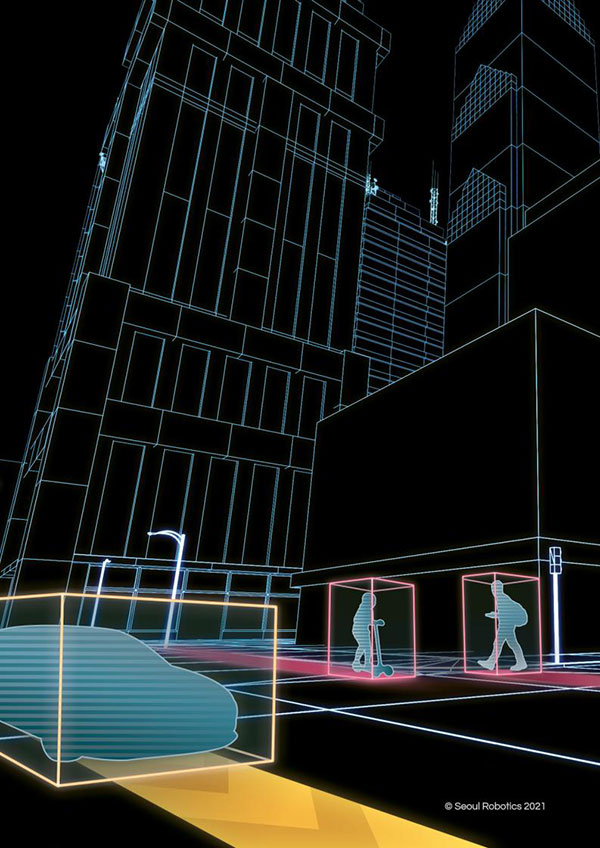
    Voyage provides highly accurate object detection, tracking and classification capabilities to enable a wide range of applications for smart cities, intelligent transportation systems, retail analytics, crowd monitoring and security. It fuses three cutting-edge technologies:

    • 3D lidar sensing powered by Seoul Robotics’ proprietary software SENSR2
    • Edge computing for minimum data burden and ease of integration
    • Built-in sophisticated perception software for instantaneous analytics

    Voyage provides centimeter-accurate 3D object detection, tracking, and classification in addition to volumetric profiling and motion prediction capabilities, regardless of lighting conditions, and can collect and process data from up to four sensors for seamless insights across the sensor coverage zones. As Voyage does not capture, show or store any biometric and otherwise identifying data, it aims to maximize the protection of people’s privacy when installed as part of various smart cities and security systems.

  • Topcon’s MAGNET7 construction and survey software out now

    Topcon’s MAGNET7 construction and survey software out now

    Survey and construction software suite MAGNET7 is now available from Topcon, using cloud-based connectivity to streamline workflows through GNSS receivers and other equipment.

    Photo: Topcon
    Photo: Topcon

    Survey and construction software suite MAGNET 7 is now available from Topcon Positioning Group.

    MAGNET7 uses cloud-based connectivity to streamline workflows through GNSS receivers, total stations and other positioning tools and instruments. It addresses common needs to increase productivity, efficiency and profitability levels across the job site.

    The software is also designed to improve accuracy while efficiently managing data and collaboration — in real time — with the project team.

    Enhancements in the MAGNET7 field version improve 3D model support, reporting and interactivity in working directly on a visual map. Also improved is data handling for large and complex 3D projects.

    Productivity features include an ability to connect to the newest version of the Sitelink3D job-site monitoring and management system. This enables office personnel to send machine models via the web portal directly to machines on site.

    The new connection also allows access to the Haul Truck app, which dramatically improves efficiency in the mass-haul environment by sending real-time data — including haul volumes and truck locations — directly to the master schedule.

    MAGNET7 provides new capability for calculating the International Roughness Index (IRI), a valuable indicator for resurfacing projects. The IRI data exports directly to ProVAL formats, commonly used in the paving industry, to report and validate road-surface smoothness against government guidelines.

    Also provided are enhanced terrain-modeling capabilities for surveyors and an overall increase in file-type capability.

    Addressing COVID-19

    COVID-19-related demands placed on construction and survey professionals underscore the need for comprehensive, integrated software solutions to meet those challenges head on, according to Alok Srivastava, senior director, product management.

    “The push to ramp up production levels and increase efficiency, while operating profitably, has never been greater,” Srivastava said. “Our suite — made up of field software, cloud services, tightly integrated office software and third-party integrations — is a key component of our digital ecosystem, all designed to enhance productivity in the field while helping the office efficiently manage the project dataset. It does so by tapping the power of integrated solutions to provide end-to-end workflows, superior data exchange and a far better level of collaboration.

    “We’ve long recognized that many of the basic needs and challenges of today’s survey and construction disciplines are similar. With that in mind, this solution provides compatible, comprehensive, connected answers to many of those shared issues.”

    “The need for digital connectivity, both on site and between the office and the job site, has never been greater,” Srivastava said. “With the continued push toward digitization in all facets of their jobs, today’s construction and survey professionals regularly risk loss of efficiency — and the financial costs associated with it — due to issues of incompatibility between equipment and systems. This upgrade of the MAGNET suite of productivity solutions takes connected field and office management to a new level, making the long sought-after ‘end-to-end workflow’ a reality while helping projects stay on schedule and under budget.”

  • Wetlands software integrated with Esri ArcGIS

    Wetlands software integrated with Esri ArcGIS

    Photo: Ecobot
    Photo: Ecobot

    Ecobot, developer of environmental data reporting software, is now integrating enhanced Esri ArcGIS mapping and data capabilities via a partnership begun in 2019 through Esri’s Emerging Partner with the Startup Program.

    The partnership enabled the addition of familiar geospatial modeling, mapping, georeferencing and data-collection capabilities within the wetland delineation app.

    The new capabilities will further automate and speed the process of wetland delineations, allowing Ecobot customers to support paperless mapping of wetlands — scientists and engineers can walk the perimeter of a wetland, dropping virtual flags with a tap on the screen.

    The Ecobot natural resources platform includes comprehensive reference materials, automated calculations, and instant generation of U.S. Army Corps of Engineers (USACE) Wetland Determination forms, along with Esri-ready shapefiles.

    The addition of Esri ArcGIS technology is expected to slash project time and costs by an additional 5%-8%.

    “Ecobot has been used to prepare more than 6,000 USACE forms for jurisdictional determinations,” said Lee Lance, Ecobot co-founder and CEO.

    “Accurate and efficient wetland mapping and data collection by scientists is critical to sound construction practices, especially in an era of climate change, when sea rise and heavy precipitation events are predicted to increase across the country,” said Dawn Wright, chief scientist at Esri.

    “We are thrilled to see one of our Emerging Business Partners taking advantage of our larger partner network to deliver Esri technology inside of a critical tool.”

  • Auterion showcases product portfolio at Xponential 2019

    Auterion, an open-source software company, showcased its product portfolio, which includes Enterprise PX4, at Xponential 2019. According to the company, Enterprise PX4 is a software that powers the drone, keeps it away from obstacles and collects the data you need.

  • V6 of Virtual Surveyor provides streamlined workflows with drones

    V6 of Virtual Surveyor provides streamlined workflows with drones

    Image: Virtual Surveyor
    Image: Virtual Surveyor

    The newly released version 6 of the Virtual Surveyor drone surveying software offers a faster, more efficient workflow and better overall user experience in a more stable platform, according to the software maker.

    Version 6 offers new capabilities, an improved licensing system and an extended free application.

    “Surveyors who have used the Virtual Surveyor package in the past will be amazed at how easily they can manipulate data and how quickly the software renders results of even the most complex topographies,” said Tom Op ‘t Eyndt, managing director of Virtual Surveyor nv in Belgium.

    Virtual Surveyor leverages the expertise and interpretation skill of a land surveyor and combines it with the computing power of the computer, the company said.The software generates an interactive onscreen environment through orthophotos and digital surface models, generated from the unmanned aerial vehicle (UAV), where the surveyor selects survey points and breaklines to define the topography.

    Image: Virtual Surveyor
    Image: Virtual Surveyor

    Virtual Surveyor enables land surveyors to complement traditional fieldwork with UAV imagery to generate highly accurate topographic products up to five times faster than otherwise possible. It bridges the gap between UAV photogrammetric processing software and engineering computer-aided design (CAD) packages.

    “The focus of Version 6 development has been to streamline the workflow — from the importing of drone data to exporting topo information into CAD — to make the surveyor more productive,” Op ‘t Eyndt said.

    Key enhancements in Virtual Surveyor 6 include the following:

    • Easier editing – The new editing functions allows users to quickly select, delete or move individual point and lines placed by the computer during the automated creation of elevation points. The associated Undo/Redo function allows reversing all edit operations.
    • Better CAD integration – The addition of Descriptor functionality means that point descriptions remain with the point during export to CAD, working the same way as the land surveyor collects data in the field.
    • 3D geometry retained – All points, lines and other data imported into the software, either from a UAV or field surveyed data, retain elevation values and integrate seamlessly into the merged scene. This allows a surveyor, for example, to collect point values from a ditch bottom that may be obscured by vegetation in the drone image and have the bottom points accurately represented in the topography.
    • Improved drawing tools – Users can now densify (drape) lines and boundaries to map current surface conditions. Individual vertices are now adjustable in all directions and exact X, Y and Z locations can be specified as well. Sub-surface modeling is now possible with these new improvements. Created features can then be exported to CAD for profile or alignment creation.
    • Extended free plan – Referred to as the Valley version, the free Virtual Surveyor suite has added functionality, including the ability to import photogrammetric data.
    • Improved licensing – We better honor our principle: “The license follows the user”. With an improved licensing system based on a Virtual Surveyor Identity (email) the user will be able to work where he or she wants.

    “The enhanced user experience will continue to appeal to professional land surveyors, who are our core client base,” said Op ‘t Eyndt. “And the seamless integration with CAD and advanced drawing tools will make Virtual Surveyor more attractive to design engineers.”

    Virtual Surveyor is available in a free 14-day trial.

  • Bentley Systems to celebrate Year in Infrastructure in October

    Bentley Systems’ Year in Infrastructure 2018 Conference will be held Oct. 15-18 in London at the Hilton London Metropole.

    Bentley Systems is a global provider of comprehensive software solutions for advancing infrastructure.

    Presented by Bentley Institute, the conference is a global gathering of leading industry executives and prominent thought leaders in the design, construction and operations of the world’s infrastructure. The theme of this year’s conference is “Going Digital: Advancements in Infrastructure.”

    The conference features nearly 70 speakers and more than 50 informative sessions, including keynotes by leading industry experts, interactive workshops, forums, panel discussions and product demonstrations. Attendees can visit the Technology Pavilion, which features exhibits and presentations from Bentley Systems and its strategic partners Microsoft, Siemens, Topcon and Bureau Veritas.

    On the first day of the conference, Bentley Institute will host Digital Advancement Academies, featuring presentations and interactive discussions with subject matter experts who provide insights and best practices in their areas of expertise including reality modeling, BIM strategy and constructioneering.

    The conference also includes the selection and announcement of the winners of Bentley’s Year in Infrastructure 2018 Awards (formerly known as the Be Inspired Awards), which honors the extraordinary infrastructure projects by users of Bentley software throughout the world.

    During six industry-focused forums featured during the conference — Buildings and Campuses, Digital Cities, Industrial Infrastructure, Rail and Transit, Roads and Bridges, and Utilities and Water — more than 55 awards finalists will present their projects to independent panels of jurors, more than 100 members of the press, and conference attendees.

    From those presentations, winners are selected by the jurors, and will be announced at the conclusion of the conference on Oct. 18 during an evening ceremony and gala.

    Aret Garip, technical director for WSP, attended Bentley’s conference last year in Singapore to represent WSP’s One Blackfriars project in London, which was chosen as an awards finalist.

    “The conference has been truly inspiring and educational,” Garip said. “It’s a great event to learn about the latest tech in engineering design software and an opportunity to meet the creative, intelligent people who develop new tools to make it easier for us to design buildings.”

    In October 2019, the Year in Infrastructure Conference will return to the Marina Bay Sands Expo and Convention Centre in Singapore.

  • Orbit GT releases UAS Mapping v17.1 with cloud feature

    OrbitGT_UAS-Mapping-v17.1-W

    Orbit GT has released v17.1 of its UAS Mapping desktop product including the all-new Upload to the Cloud feature. It is available for download from the company website.

    “This upgrade includes the capability to upload any UAS Mapping content directly to www.3dmapping.cloud, our SaaS based sharing and collaboration platform,” said Peter Bonne, CEO of Orbit GT. “It adds a great new feature for everyone collecting and creating drone based content.”

    Upload to the Cloud allows for users to instantly bring their drone/UAS/UAV data online. The upload process is fluently integrated in the known workflows of the product, with the required checks and validations. Upload time depends on the internet connection.

    Once uploaded, the data is immediately available for sharing on www.3dmapping.cloud. The new Catalog tool adds insight and overview of all data collection jobs done, indisspensible to manage large jobs.

    The update is free for holders of a license with maintenance.

  • Sokkia introduces field-to-office GeoPro software

    Sokkia introduces field-to-office GeoPro software

    Sokkia has introduced a pair of software solutions for its total stations, robotics and GNSS rover systems — GeoPro Field and GeoPro Office.

    Sokkia GeoPro Field software.

    GeoPro Field provides a graphical user interface designed to collect field measurements for land surveying and construction activities.

    “End-users needing a field tool to collect and import measurement data into design and drafting software will find GeoPro Field to be a fast and accurate method that will increase productivity with CAD functionality in the field,” said Ray Kerwin, director of global surveying products. “A key to GeoPro Field is its compatibility with various software workflows — point files are easily exported to third-party software.”

    Sokkia GeoPro Office software.

    Sokkia GeoPro Office is the office-processing complement to the field software — designed to clean, process, and analyze field data into its easiest-to-use form. “Users will immediately see the benefit in time saved, when compared to a variety of traditional manual methods,” Kerwin said.

    The office software can also be expanded with an optional 3D and road design module, for further versatility to design roads with the processed field measurements.

    “The Sokkia GeoPro Field and Office have user-friendly graphical interfaces, with simple in-field functions and office workflows. The user can get to work quickly due to the intuitive interface and simplicity of operation without the need for advanced training,” Kerwin said.

  • Next-generation of grade control integrates 3D automatics

    Next-generation of grade control integrates 3D automatics

    (Photo: Trimble)

    Trimble is offering Trimble Earthworks for Excavators and Earthworks for Dozers. Trimble Earthworks is transforming machine control with integrated 3D aftermarket excavator automatics capability.

    In addition, a new dozer configuration moves the receivers from the blade to the roof of the cab. Reengineered from the ground up, Trimble’s innovative, next generation grade control platform features intuitive, easy-to-learn software that runs on an Android operating system.

    State-of-the-art software and hardware gives operators of all skill levels the ability to work faster and more productively than ever before, Trimble said.

    “Trimble pioneered machine control,” said Scott Crozier, director of marketing for Trimble Civil Engineering and Construction. “Now, Trimble Earthworks takes machine control to the next level, with a platform that reinvents machine control technology, making it easy to use and learn, and more accessible for many different types of contractors.”

    Live demonstrations of Trimble Earthworks for Excavators and Trimble Earthworks for Dozers will be showcased at ConExpo 2017, March 1-7, one of the world’s largest international exhibitions for the construction industry. Trimble will be located in the Las Vegas Convention Center North Hall #N-12067.

    Intuitive Software. The Trimble Earthworks grade control application is built on the Android operating system, and runs on the new 10-inch (25.7 centimeter) Trimble TD520 touch-screen display. The Earthworks application was developed based on feedback from construction equipment operators around the world, resulting in an interface optimized for productivity.

    Colorful graphics, natural interactions and gestures, and self-discovery features make the software intuitive and easy to learn. Each operator can personalize the interface to match their workflow and a variety of configurable views make it easier to see the right perspective for maximum productivity.

    In addition, Earthworks allows data files to be transferred to or from the office wirelessly and automatically so that the operator is always using the latest design. Using the Android operating system, users can download other applications that provide the operator with additional useful tools inside the cab. To make the system even more flexible, contractors can use the Trimble TD520 display or a third-party Android device.

    Excavator Automatics. With Trimble Earthworks, contractors can now take advantage of the first integrated 3D aftermarket grade control automatics for excavators, allowing operators to create smooth, flat or sloped surfaces more easily.

    When the excavator is placed in Autos mode, the operator controls the stick, and Trimble Earthworks controls the boom and bucket to stay on grade, reduce overcut and increase production. By automating excavator operation, Trimble Earthworks allows operators to achieve grade consistently, with high accuracy and in less time.

    Mastless Dozer Configuration. Trimble Earthworks for Dozers mounts dual GNSS receivers on top of the cab to eliminate masts and cables traditionally located on the blade. The dual-GNSS receivers are ideal for steep slope work and complex designs with tight tolerances. The new configuration keeps valuable receivers safer and can also save contractors time by reducing the time needed to remove and reinstall them each day.

    Trimble Earthworks for Excavators is expected to be available globally in the second quarter of 2017 from the SITECH dealer channel. Trimble Earthworks for Dozers is expected to be available in the second half of 2017 from the SITECH dealer channel.

  • CartoPac software suite adds iOS support

    Image: CartoPac
    Image: CartoPac

    CartoPac International Inc. has added iOS mobile operating system support to its CartoPac software suite. CartoPac also supports Windows and Windows Mobile applications, but the company says the addition of iOS enables it to deliver advanced mobile functionality to a broad range of devices used for geospatial data collection.

    “Companies struggle to find single mobile software that supports the diverse requirements and robust functionality needed for both asset inventory and inspection workflows,” says Glenn Vlass, CartoPac’s vice president of marketing and product management, in a news release. “With the recent addition of mobile for iOS, our software gives organizations a single platform to author, publish, deploy and manage mobile solutions for their entire workforce.”

    Since its introduction in 2002, the company says the CartoPac suite has been adopted by energy companies, natural resource agencies and municipalities, as well as gas and electric utilities, to manage their assets. CartoPac applications are fully integrated with Esri GIS solutions.

    The suite has the ability to configure solutions that leverage data from both the GIS database and other enterprise databases, such as work order management systems.

    CartoPac Workflow Manager, a module in the suite, supports configured structured processes for bringing field data back to the enterprise. CartoPac also supports both fully integrated on premise deployments and complete hosted deployments using CartoPac Core.

    “Regardless of the field device, the captured or updated data will be complete, consistent and accurate,” Vlass says.

  • CHC Navigation features GIS solutions at Intergeo 2016

    CHC Navigation focused on its new GIS products at Intergeo 2016, which was held Oct. 11-13 in Hamburg, Germany. Balazs Hober discusses the LT600 GNSS handheld, DigiTerra Explorer 7 software and LT40 smartphone with L1 RTK capability that can achieve 30-centimeter accuracy.

  • Research: Accelerating GNSS software receivers

    Research: Accelerating GNSS software receivers

    By Carles Fernandez–Prades, Javier Arribas and Pau Closas, Centre Tecnologic de Telecomunicacions de Catalunya, Spain. Presented at ION GNSS+, September 2016.

    This paper addresses both the efficiency and the portability of a computer program in charge of the baseband signal processing of a GNSS receiver. Efficiency, in this context, refers to optimizing the speed and memory requirements of the software receiver. Specifically, the interest is focused on how fast the software receiver can process the incoming stream of raw signal samples and, in particular, if signal processing up to the position fix can be executed in real-time (and how many channels the host computer executing the receiver application can sustain in parallel).

    Diagram of Typical Code and carrier tracking loops in a GNSS receiver. Colored dotted-line boxes show functions implemented in SIMD technology. Lanes “16ic” are data streams whose items are complex numbers with real and imaginary components represented with 16-bit integers, whereas “32fc” indicates those with complex numbers with real and imaginary components in 32-bit floating point representation.
    Diagram of Typical Code and carrier tracking loops in a GNSS receiver. Colored dotted-line boxes show functions implemented in SIMD technology. Lanes “16ic” are data streams whose items are complex numbers with real and imaginary components represented with 16-bit integers, whereas “32fc” indicates those with complex numbers with real and imaginary components in 32-bit floating point representation.

    This is achieved by applying the concept of parallelization at different abstraction levels. The paper describes strategies based on task, data and instruction-level parallelism, as well as actual implementations released under an open source license and the results obtained with different commercially available computing platforms. At the same time, the proposed solution also addresses portability, understood as the usability of the same software in different computing environments.