Sponsored by: Hemisphere GPS
Broadcast Date: June 21, 2012
Moderator: Eric Gakstatter,GPS World contributing editor for Survey & GIS
Speaker: Craig Greenwald, GeoMobile Innovations. Craig Greenwald is the technical director at GeoMobile Innovations and a Mobile Technology Specialist. He has worked in the Mobile GIS industry for over 10 years, including seven years for GIS software leader at Esri. He is a highly experienced software developer (C++, C#, JavaScript, VB, and VBScript), consultant, and trainer, specializing in Mobile GIS and field data collection applications and technology. Craig is well known for his work on the ESRI ArcPad team.
Summary: The market for mobile devices; smartphones, handhelds, and tablets is exploding. When Microsoft Windows Mobile used to be the dominant operating system on mobile devices, purchasing apps didn’t require a second thought. However, that isn’t the case any longer. Google’s Android and Apple’s iOS operating systems are now the dominate operating systems on mobile devices. This is a challenge because virtually all high-precision GPS/GIS/Surveying data collection apps are still written for Windows Mobile. Will vendors port their apps to Android and/or iOS? Will they use a cross-platform software environment like Java or HTML5?
Tag: software
-
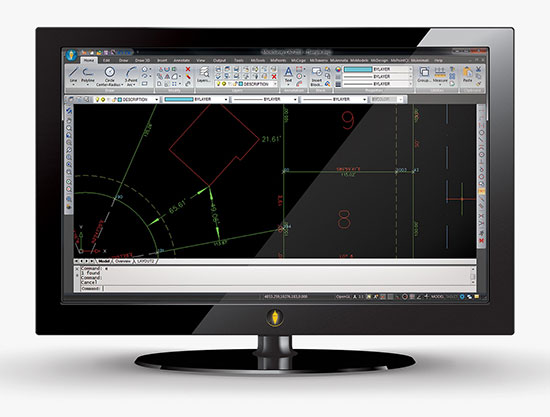
Mobile GIS: What’s the New Normal? Windows, Android, iOS, Open Source?
-
Topcon invests in virtual reality company for construction, infrastructure
Topcon Positioning Group has acquired a significant share of holdings a company that assists customers in virtual design and construction (VDC).
Viasys VDC — based in Espoo, Finland — has developed a suite of tools and services to assist customers in building virtual models for infrastructure and site-work projects. Using building information modeling (BIM) technologies, its solutions create VDC models that optimize the construction process throughout the project’s lifecycle, creating enhanced quality, higher efficiencies and reduced costs, Topcon said.
“Viasys VDC solutions allow for the import of virtually any BIM or non-BIM design model, offering seamless interoperability with open design standards currently in the market — which provides the contractor or engineer with full control and visibility of the entire design throughout the entire project,” said Heikki Halttula, CEO and president, Viasys VDC Ltd. “With advanced simulation tools and communication functions, design-build issues can be detected before actual work starts, or at any time during the process.”
Accurate 5D simulation allows for optimal planning and execution, Topcon said in a news release. Other significant features include cloud-based collaboration functions as well as mobile access to models and information on-site.
Topcon currently offers various BIM and remote site management/visibility solutions aimed at many of the markets served by Viasys VDC.
“Now, with our investment in Viasys VDC, we have partnered with the technology leader to allow us to offer an expanded platform for the future generation of advanced Topcon VDC solutions with seamless BIM interoperability for our partners and customers,” said Ewout Korpershoek, Topcon executive vice president for mergers and acquisitions.
“Partnering with Topcon is an exciting step forward to help advance our industry-leading VDC solutions, while also expanding their reach to a global audience,” Halttula said. “With Viasys VDC offices in Finland, California and Vietnam, we are also well positioned geographically to work directly with existing Topcon operations in Europe, North America and Asia.”
In addition to a full suite of BIM-based mobile workforce solutions, Viasys VDC offers an operational asset management solution as a basis for lifetime maintenance of the VDC managed projects.
-
MicroSurvey CAD 2016 provides new capabilities for survey
MicroSurvey Software has released MicroSurvey CAD 2016, the newest generation of its desktop survey and design program for land surveyors and civil engineers. Powered by a new IntelliCAD 8.1a engine and enhanced with a suite of new point-cloud management tools, the software makes high-impact drafting and design fast and intuitive, the company said.
Users on multi-core computers will experience up to 300 percent faster performance compared to previous versions, which substantially improves productivity. Navigation has been enhanced through a new ribbon interface with high-resolution icons that provide easy access to frequently used tools. The newest version of the software is also able to open and export DGN files, handle annotation scaling, and publish drawings as DWF/DWFX, PNG and JPG files.
Point Clouds. The new release includes significant enhancements for working with point clouds. The Ultimate and Studio versions of the software are now powered by the same point-cloud engine that drives Leica Cyclone and CloudWorx software, making it possible to directly import Leica Cyclone and Leica JetStream databases using Cyclone dialogs.
Users can view panoramic photographs captured by the laser scanner and snap to points directly from the photographs in a TruSpace window. Point-cloud data is now displayed directly within the CAD model space, and users can snap to the point-cloud points using standard CAD tools.
MicroSurvey CAD is compatible with field data from all major total stations and data collectors and is fully compatible with AutoCAD. It includes complete survey drafting, COGO, DTM, traversing, volumes, contouring, point-cloud manipulation and data-collection interfacing. No plug-ins or modules are necessary. Both a 64-bit version and a 32-bit version of the software are available.
-
MicroSurvey FieldGenius 8 Provides Control in Field Data Collection
The newest version of MicroSurvey FieldGenius delivers expanded toolsets and enhanced capabilities for fast, accurate and complete field data collection, according to maker MicroSurvey Software. FieldGenius 8 was developed through close market collaboration and feedback from users, and provides tight control over crucial aspects of field data collection through expanded toolsets and an enhanced user experience, the company said.
Benefits of the new release include:
- Easy GNSS Local Transformation. A redesigned interface provides a streamlined workflow along with the ability to export/import localization files and use Helmert transformation.
- Enhanced DXF Support. Blocks, extrusion vectors, circles, and other entities are now supported in DXF file format for faster and easier drawing import.
- Advanced Point Averaging. The routine allows users to take multiple GNSS and/or TPS temporary measurements of a point and calculate an averaged position for increased accuracy and reliability.
- All-New Electronic Bubble. Integrated inertial sensors are now supported, which enables tilt compensated surveying on selected receivers and improves efficiency at difficult job sites.
- Native Unicode Support. Unicode character encoding has been implemented throughout the program. International users can now use their own language for data entry inside FieldGenius.
- Simplified GIS Mapping. GIS attributes can now be easily added to figures. In addition, users can quickly access default/previous values for both points and figures to make mapping tasks even easier.
FieldGenius 8 also includes improvements to road alignments, an onboard basic measurement mode, dynamic screen rotation, and expanded ASCII export options. Additionally, supported coordinate systems, geoids, instruments, and data collectors has been expanded, making it easier to integrate into existing survey operations.
-
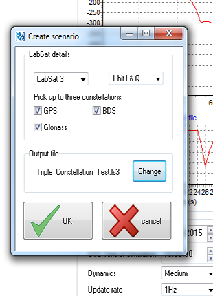
LabSat’s SatGen v3 Adds BeiDou to Simulator Scenarios
SatGen v3 software is now available for the LabSat GNSS simulator by Racelogic. Version 3 includes BeiDou (BDS) in addition to GPS and GLONASS.SatGen is billed as a powerful and intuitive software package that gives users the ability to create scenarios for replay through any LabSat simulator. The software creates either user-generated or imported trajectory files for use with a LabSat simulator.
The addition of the BeiDou B1 signals means that users can now test a device’s effectiveness as if it were being used within the operating area of the Chinese constellation, which at present only provides full coverage in Asia.
The BeiDou constellation is set to become globally operational by 2020. With the new SatGen v3, users can create scenarios that include signals from satellites yet to be launched, so new products can be developed in readiness for the full constellation.
SatGen v3 can produce scenarios with one, two or three sets of signals being simultaneously output: GPS, GLONASS and now BeiDou. The software now matches the record and replay abilities of the LabSat 3 simulator.
A trial of SatGen is available here. To purchase a full copy contact a LabSat distributor.
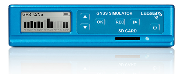
The LabSat 3 GNSS simulator. -
Data Mapper Offers Cloud-Based UAV Software for Imagery
Data Mapper, an enterprise aerial data software by PrecisionHawk, will expand its cloud-based platform to process data collected by a wider network of unmanned aerial vehicle (UAV) providers. The application provides the ability to upload, store, process and share aerial imagery and is equipped for detailed, automated analysis.
Previously the company was known under the name PrecisionMapper, and the software could only be used when collecting aerial data with the PrecisionHawk UAV platform Lancaster HawkEye Mark III.
“As we began to collect data with the PrecisionHawk UAV across data intensive industries, we discovered a clear gap in the market for an end-to-end, enterprise level solution,”said Christopher Dean, CEO of Data Mapper. “The creation of Data Mapper was a way for us to ensure that what matters most to our customers, the ability to transform aerial data into actionable information, was available quickly and cost effectively.”
The platform is accessible on numerous devices and allows a user to see data in real time, long before a processed orthomosaic is available. Post processing is automated, and processed data can be shared across devices or analyzed using sophisticated algorithms. Data Mapper geospatial experts have been working closely with university partners across the nation to determine the most pressing algorithms for the agriculture industry such as plant height, weed detection, plant counting and canopy cover.
Because of its early integration with the PrecisionHawk platform, Data Mapper has a strong client base that includes Fortune 500 companies, global agriculture companies, education and research institutions and individual agricultural producers, PrecisionHawk said.
As the UAV industry quickly expands, data intensive markets such as agriculture can be equipped with a streamlined, information delivery structure that fits into an everyday workflow. Engineers have bootstrapped the technology to ensure seamless integration with workflows that rely heavily on accurate information to support business practices, PrecisionHawk said.
“UAVs are an extremely effective and efficient means for collecting data, but the value of this technology goes far beyond an aircraft,” said Andrew Slater, VP of software development for Data Mapper. “Data Mapper is a tool designed to close the gap between a service that UAVs provide and the value of that service, which isinformation delivery to the right person at the right time.”
The company has worked with data sets across a variety of industries including agriculture, oil and gas, emergency response, forestry and insurance, and will continue to extend its analysis capabilities to different markets. Data Mapper will significantly grow its employee base, hiring geospatial analysts, software engineers and embedded software engineers to work towards a generalized ingestion method for all UAV data in 2015.
-

Topcon Announces Upgrade to Reference Station Network Software
Topcon Positioning Group announces new reference station network software — TopNET+ v10 — bringing new features and functionality to the TopNET+ reference station software suite.
Topcon’s TopNET+ software is a scalable solution supporting everything from a single CORS station to multiple CORS sites covering a large geographical area. Users of a TopNET+ reference network get GNSS RTK correction data generated using information from all reference stations in a network. This feature allows regional use of RTK while providing data that is specific for each local rover, Topcon said.
New features available in the latest TopNET+ v10 include:
- Custom sub-networks based on a rover’s position within a larger regional network, which better supports the network RTK rover to local field conditions;
- RINEX (Receiver Independent Exchange Format) shop with expanded data management functionality for conversion of data from Topcon and third party reference stations connected to the network;
- Background maps and BING Maps allow multiple perspectives of the network orientation and regional surroundings;
- Expanded network RTK engine logging providing detailed metrics of TopNET+ results.
“This upgrade of TopNET+ software provides increased capabilities and a more visual and detailed presentation of network status to the users of Topcon networks,” said Tom Morris, TPS senior product development manager. “Users will have a customized solution better adapted to local conditions and a better view into the hard processing and statistics being generated in TopNET+.”
-
RTKLIB Open Source GNSS Precise Positioning Software Supports NV08C Receiver
RTKLIB, a developer of open source software for standard and precise GNSS positioning, has released its latest RTKLIB software (version 2.4.2), which fully supports NVS Technologies’ BINR proprietary binary protocol and the NV08C GNSS receiver series.
The use of RTKLIB, in conjunction with NVS Technologies’ NV08C GNSS receiver series, including the highly integrated NV08C-CSM surface mount module with geodetic grade raw data output, enables GNSS system designers and OEMs to develop highly accurate, low cost and compact precision-grade positioning and navigation equipment.
RTKLIB features include:
- Full compatibility with NVS Technologies’ NV08C Series GNSS Receivers.
- A portable program library and several APs.
- Standard and precise positioning algorithms using GPS, GLONASS, Galileo, QZSS, BeiDou and SBAS.
- Supports various GNSS based positioning modes, both for real-time and post-processing, including: Single, DGPS/DGNSS, Kinematic, Static, Moving-Baseline, Fixed, PPP-Kinematic, PPP-Static and PPP-Fixed.
- Positioning mode for real‐time and post‐processing, including Single, SBAS, DGPS, RTK, Static, Moving‐base and PPP.
- Supports many standard formats and protocols for GNSS, including RINEX 2 & 3, RTCM 2 & 3, BINEX, NTRIP 1.0, RTCA/DO-229C, NMEA 0183, SP3-c, ANTEX 1.4, IONEX 1.0, NGS PCV and EMS 2.0.
- External communication via Serial, TCP/IP, NTRIP, local log file (record and playback) and FTP/HTTP (auto download).
Contact NVS Technologies for specific features compatibility. Visit www.rtklib.com for RTKLIB’s latest (ver. 2.4.2) software package download, release note, information, tutorial, manual and support.
-
Large Turn-Out Demonstrates Government’s Interest in Open Source Software
A sold-out crowd of more than 650 people filled the Kossiakoff Conference Center at the Johns Hopkins Applied Physics Laboratory on Wednesday, 30 May 2012 to participate in the Open Source Industry Day co-hosted by the National Security Agency and the Open Source Software Institute.
“The Open Source Industry Day event could not have gone better,” said event volunteer co-chairman John Farrell of HP Enterprise Security. “We had a sell-out crowd, fantastic speakers and packed panel discussions that kept audience and panelist engaged all day. Our thanks go to the many volunteer supporters and government participants who worked together to make this event successful.”According to the day-long, unclassified event featured senior-level government leaders, tech industry representatives and open source community experts who participated in interactive panel discussions covering a range of topics identified by government users as specific areas of interest.“We worked closely with our government partners to choose topics that were timely and relevant to helping meet their interest and mission needs,” Farrell said. “After we agreed on a set number of primary topics, we reached out to the top-level experts in each field and were flooded with responses from speakers and subject-matter experts. The overwhelming success of this event helps to demonstrate the level of interest for open source software solutions by government agencies.”A list of discussion topics and participating speakers is available at the OSSI website: oss-institute.org.The event also featured highly-regarded keynote speakers from the Defense and Intelligence Communities. Keynote speakers included John A. Marshall, Chief Technology Officer at US Joint Chiefs of Staff, J2 Intelligence Directorate; Charlie Stein, Program Executive Office for Information Assurance at the National Security Agency; Don Davidson, Chief Outreach & Standardization (Trusted Mission Systems & Networks) at US Department of Defense; and Dan Risacher of the Office of CIO at US Department of Defense.As follow up to the Industry Day, OSSI is using the feedback from the event to prioritize follow up discussions at their regular monthly meetings and there will be a “Call for Papers” shortly.“The event attracted leaders and senior level professionals from nine government agencies and more than 300 corporations in what can only be described as an open and honest discussion,” said OSSI Regional Director Carl Livesay. “OSSI leveraged resources in the open source community to organize, manage and provide speakers for the event. The results were a tremendous value to attendees and a collaboration from contributors. We thank those who attended and those who contributed.”OSSI is in discussion with several other government agencies to hold similar events focused on their individual missions. -
Trimble Introduces New Versions of their Business Center and Access Software
Trimble introduced new versions of its office and field surveying software—Trimble Business Center Software version 2.70 and Trimble Access software version 2012.10. The software is part of Trimble’s portfolio of Connected Site survey solutions. The new software enhancements allow surveyors to collect, share and deliver data faster to improve accuracy, efficiency and productivity.
“Trimble is focused on providing Connected Site solutions that minimize rework and improve productivity. Workflow integration and connectivity provide surveyors with the day-to-day flexibility to adapt to a variety of situations in the field and office,” said Anders Rhodin, director of Trimble’s Survey Business. “Trimble’s portfolio of software solutions gives surveyors improved workflows for field data collection and enhance collaboration between the field and the office.”
Trimble Business Center Software Version 2.70
Version 2.70 advances the capabilities of surveying offices with key new functionality, including:
Photogrammetry – When a surveyor’s project contains images from Trimble VISION™ Total Stations or Trimble VX Spatial Stations, users can make photogrammetry measurements and calculate points with three-dimensional (3D) coordinates.
Support for Polygon Features – Using the Feature Definition Manager application, surveyors can create and edit polygon feature definitions for inclusion in a library (.fxl) file. Polygon features are useful for modeling real world terrain features such as bodies of water, building footprints, and parcel boundaries.
New GNSS Baseline Processor – The baseline processor has been enhanced to provide improved accuracy and support for RINEX 3.0 and ANTEX antenna model formats. Users can post-process GNSS observables faster by taking advantage of multi-core computer processing. By decreasing the time it takes to process baselines, the software enables office surveyors to spend more time analyzing results and creating deliverables.
Trimble Access version 2012.10 offers new functionality, including:
Volume Calculation and Surface Creation – Surveyors can now compute volumes and create surfaces in the field on any of the following: Trimble Tablet, TSC3, TSC2, or Trimble CU Model 3 Controllers, plus the Trimble S3 and Trimble M3 Total Stations.
Panorama Image Capture – All Trimble S Series total stations equipped with Trimble VISION technology can now take multiple images seamlessly using the panorama function.
Target Interrupted Measurements – A new “Interrupted Target Measurement” feature is now available on all Trimble VX Spatial Stations and Trimble S8 and S6 Total Stations. This feature allows successful measurements in difficult environments where a measurement is likely to be interrupted – for example, when surveying across a busy road.
OmniSTAR Support – Customers with a Trimble R7 GNSS System, the latest version of Trimble Access and a subscription to OmniSTAR corrections signals, can now take advantage of real-time, differential positioning without a radio link. OmniSTAR services can be used for real-time differential surveys or as a fallback for RTK surveys when a ground-based radio link is down or unavailable.
Trimble’s Connected Site Solutions
Trimble’s Connected Site solutions for surveyors create seamless working relationships among Trimble products, technologies and services. Through the Connected Site, Trimble is focused on providing solutions that address the customers’ full work processes. By carefully combining technology innovation with a deep understanding of the users’ workflows, data integration and maintenance across the lifecycle of projects, Trimble helps surveyors reach new levels of productivity for their businesses.
Availability
Trimble Business Center Software version 2.70 and Trimble Access software version 2012.10 are available now through Trimble’s Survey Distribution Channel.
-
Leica Geosystems Announces Leica MissionPro Software
Leica Geosystems Geospatial Solutions Division is pleased to announce the release of its new mission planning software, Leica MissionPro. The software provides mission planning capability for all airborne sensors including LiDAR, line and frame sensors and is fully integrated into existing Z/I Imaging and Leica Geosystems workflows.
The company reported that in addition to the core planning functionality, Leica MissionPro includes an exciting range of new features such 3D virtual Globe View and tools for project management and evaluating missions.
“Leica MissionPro combines the best features from Z/I Mission and Leica FPES into a comprehensive and highly productive planning software”, says Jacques Markram, Product Manager for Leica MissionPro. “Leica MissionPro represents an exciting first step in our combined product roadmap and is truly the result of synergies across the new division. Leica MissionPro simplifies planning for any type of airborne sensor mission and allows our combined customer base to further enhance their productivity.”
According to Leica, MissionPro supports integrated multi-sensor and LiDAR planning in a true 3D mission planning environment and exports flight plans for both Z/I Inflight and Leica FCMS. In addition, Leica MissionPro provides access to Web Map Services and uses worldwide SRTM data.
Leica MissionPro replaces Z/I Mission and Leica FPES software. A free upgrade is provided to all Leica FPES and Z/I Mission maintenance customers.
For more information about Leica MissionPro please visit: http://www.leica-geosystems.com/missionpro