South Korea has launched a test operation of a new GPS-based positioning service, reports the Korea Herald. The Gridded Virtual Reference Station (G-VRS) works without an internet connection to provide real-time location data with centimeter-level accuracy.
The G-VRS will complement the current VRS system for users in remote areas with unstable internet connections — islands, mountains or fast-moving vehicles.
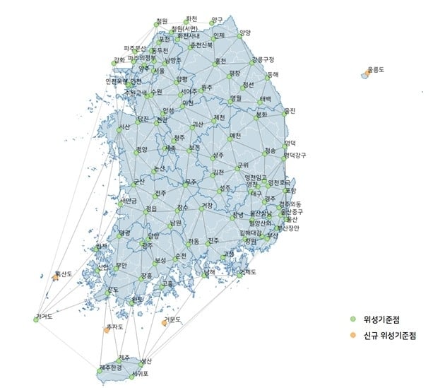
GNSS control points have been installed across the country, including four on Jeju Island and one in Gageodo, an island off the southwestern coast. The state plans to install additional points on four islands, including Ulleungdo, about 120 kilometers off Korea’s eastern coast, to operate 103 control points in total by the end of this year.
Anduril Industries is expanding into South Korea, opening a new office in Seoul. The company has also appointed a new local country leader and is forming partnerships with Korean companies to develop defense technologies for the region.
The move coincides with a two-day visit to the Republic of Korea by company founder Palmer Luckey, who is meeting with government officials and industry leaders.
The Seoul office is Anduril’s first in South Korea. John Kim has been appointed vice president and head of Anduril Korea. Kim previously led Boeing Korea’s defense business and served as the company’s interim president. He brings extensive experience working with the U.S. military and South Korea’s defense sector. The company plans to expand its local team and expects to double its headcount within 12 months.
South Korea’s Ministry of Defense has prioritized artificial intelligence, autonomous systems, and networked weapons as part of a modernization effort coordinated by the Joint Chiefs of Staff. Military planners say current defense systems are insufficient to deter or prevail in future conflicts.
As part of the expansion, Anduril will sign a contract with Korean Air’s Aerospace Business Division to co-develop unmanned aerial systems, license production of additional Anduril products for the Indo-Pacific market and explore the possibility of building a manufacturing and production facility in South Korea. The agreement is expected to establish a cooperative defense technology framework in the region.
“Anduril is committed to helping the Republic of Korea in its mission to develop a technologically advanced, highly networked armed force with fewer but more precise platforms,” Kim said. “Our new office and team expansion is further demonstration of this ongoing commitment.”
Founded in 2017, Anduril employs more than 6,000 people and is valued at over $30 billion. The company has delivered advanced defense capabilities to the U.S. Department of Defense, the Australian Defence Force and the U.K. Ministry of Defence. The new Seoul office will expand Anduril’s growing footprint in the Indo-Pacific.
South Korea’s military has reported that North Korea disrupted GPS signals from border areas for the fifth consecutive day, impacting numerous civilian flights and maritime vessels. This interference originated from the western border cities of Kaesong and Haeju, North Korea.
According to NBC News, the GPS jamming affected the West Sea (Yellow Sea) area. While the exact number of affected flights and vessels was not specified, the disruption was significant enough to prompt warnings from South Korea’s Joint Chiefs of Staff (JCS) to aircraft and ships operating near the western border.
“We urge North Korea to stop GPS interference provocations immediately and strongly warn that it will be held fully accountable for any resulting consequences,” South Korea’s joint chiefs said in a statement.
The incident occurs amidst escalating tensions between North and South Korea. It follows recent provocations by North Korea, including test-firing of advanced solid-fuel ICBMs, launching balloons carrying waste and propaganda into South Korea and allegations of North Korean troops being deployed to support Russia in Ukraine.
Aviation specialists have expressed concerns about the risks posed by these jamming activities, including potential dangers to commercial airlines flying in poor visibility, complications in airline operations, and violation of international conventions on navigational safety.
The GPS jamming is seen as part of North Korea’s electronic and psychological warfare tactics, highlighting the vulnerability of South Korea’s critical infrastructure, notably the Incheon International Airport.
Experts warn that jamming attacks can lead to serious incidents, including potential aircraft accidents in worst-case scenarios. The ongoing situation underscores the complex security challenges in the Korean peninsula and the broader implications for regional navigation stability.
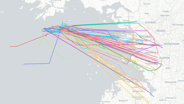
Aircraft operating near Seoul, South Korea spoofed to points in the ocean 28 to 30 May 2024. (Image: SkAI Data Services)
On the morning of May 30, 2024, Benoit Figuet posted on X that 40 aircraft operating into and out of South Korea had been spoofed over the previous 18 hours.
Professor Jiwon Seo at South Korea’s Yonsei University reports that the interference has, as of June 3, entered its fifth consecutive day.
Benoit Figuet is the co-founder of SkAI Data Services in Zurich, Switzerland. In collaboration with the Zurich University of Applied Sciences, SkAI created the world’s first public Live GPS Spoofing Tracker website. The site uses ADS-B data to detect and display in near-real time, aircraft being spoofed around the world.
South Korean military authorities have identified North Korea as the source of interference.
While the spoofing exhibits many of the same traits as interference in the Black Sea and elsewhere, Figuet has noted some differences. “We even see aircraft impacted at low altitudes,” he said. “We have observed this happening below 5,000 feet and even affecting an aircraft taxiing on the ground at the airport. The source must be at a reasonably high elevation or fairly close by.”
North Korea has a history of engaging in hybrid, non-kinetic warfare by interfering with GPS in the South, though this is the first large-scale event since one lasting from March 31 through April 5, 2016.
During the 2016 event, five different locations along the border of South Korea were identified as sources of interference. One is at an elevation of approximately 740 m and only 30 km from Inchon International Airport.
Another unique feature of the ongoing interference, according to Figuet, is the dynamic nature of the spoofed location. Unlike previously observed “circle spoofing,” the reported locations generally appear as tracing a figure eight pattern in the ocean near a point where the territorial seas of both countries meet.
Some of the spoofed locations have also been observed drifting over the North Korean border.
Local media have reported that the interference seems to be in conjunction with maritime maneuvers being conducted by the South Korean Navy and police vessels. The North has complained about intrusions into its territorial sea during these operations, a claim disputed by South Korea.
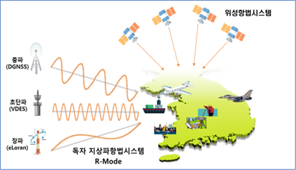
To help counter the effects of the North’s interference, South Korea has added to and upgraded its eLoran system. It has also included the eLoran upgrade in a comprehensive resilient PNT architecture that includes television signals and plans for a regional positioning, navigation and timing (PNT) satellite system.
According to Pyo-Woong Son, Ph.D., “South Korea is set to enhance its navigation and service reliability with the fully operational and established eLoran system. This system is expected to ensure that ships can navigate safely even during large-scale GPS signal disruptions, like those the country has recently experienced.” Son is a Senior Researcher at the Korea Research Institute of Ships and Ocean Engineering.
“In addition to maritime applications, eLoran will significantly contribute to the reliable operation of autonomous vehicles, such as urban air mobility (UAM), which are rapidly gaining popularity as future modes of transportation.”
“Furthermore, eLoran will play a crucial role in enhancing the reliability of public and private sector services, including broadcasting, telecommunications, and finance, where precise timing synchronization is essential,” according to Son.
Loran-C was used in many aircraft for decades before the advent of GPS. While eLoran signals are available across most of the Far East, receivers are not included in the navigation suites of commercial aircraft.
Aircraft operating into and out of Incheon International Airport have, so far, been able to use local terrestrial aviation-specific navigation aids to safely approach, land and depart.
Mr. Dana A. Goward is President of the Resilient Navigation and Timing Foundation and is a frequent contributor to GPS World.
Hexagon’s Autonomy & Positioning division and Munhwa Broadcasting Corporation (MBC) have partnered to bring precise positioning to South Korea through the TerraStar-X Enterprise Correction Service. The hardware-agnostic correction service provides instant convergence and lane-level accuracy in automotive, mobile and autonomous applications.
As a leader in real-time kinematic (RTK) positioning across South Korea, MBC’s atmospheric data enhances the redundancy of Hexagon’s fast converging and reliable precise point positioning (PPP) network across the country. Through this collaboration, the TerraStar-X Enterprise service is now supported in testbeds across South Korea, China, Japan, Europe, and North America to accelerate development for advanced driver assistance systems, safety-critical applications, micromobility, industrial and smartphone applications.
“With TerraStar-X Enterprise Correction Services now available across autonomous and consumer market applications, developers can design once and then deploy that design at scale worldwide,” said Paul Verlaine Gakne, positioning services product manager at Hexagon’s Autonomy & Positioning division. “TerraStar-X Enterprise is designed to be as flexible as possible for large-scale testing and deployment.”
The companies on June 29 signed a precise-positioning business partnership agreement that KT hopes will enable precision location services for autonomous vehicles, drones and urban air mobility.
Swift Navigation’s precise-positioning platform improves location accuracy from several meters to centimeters, enabling safer driving, improved efficiency for last-mile delivery and commercial transport operations, and enhanced accuracy for mobile devices.
South Korea has successfully launched a precision aviation satellite Thursday by leasing space on Malaysia’s MEASAT-3d communication satellite for 15 years, reports The Korea Herald. The first satellite for the Korea Augmentation Satellite System (KASS) will improve the accuracy and reliability of GPS signals for pilots, increasing airline flight safety.
The satellite lifted off from Guiana Space Center in Kourou in French Guiana at 6:50 a.m. Thursday (Seoul time), and successfully separated from the rocket at around 7:18 a.m. after the fairing and first stage rocket separations.
In development since 2014, the KASS system can improve the GPS position error to 1.0 to 1.6 meters from the current 15-33 meter level in real time to ensure positioning reliability throughout the country.
The government plans to begin a pilot service around December before its full-fledged operation next year.
South Korea is the seventh country to have a geosynchronous satellite system officially registered with the International Civil Aviation Organization (ICAO). The others are the United States, Russia, China, the European Union, India and Japan.
The Korea Augmentation Satellite System will improve airline safety over Korea. (Photo: ugurhan /iStock/Getty Images Plus/Getty Images)
Smart GEO Expo 2021 takes place at the Coex Hall C3 and C4 in Seoul, South Korea, July 21-23. An online version will also be available.
The Smart GEO Expo aims to promote spatial information industry development and support overseas expansion of domestic companies.
The Smart GEO Expo has become an annual event since 2008, when separate events such as GIS Korea, Cadastral Innovation Expo and Measurement Day were integrated and expanded, owing to the reorganization of government departments related to spatial information.
The expo includes an exhibition where host, organizers and many other geospatial information-related companies and agencies provide showcases. The event also includes the International Meeting for the Advancement of the Geospatial Information Cooperation for expansion of exchange and information sharing with foreign guests.
On March 20, a South Korean Earth Observation satellite will be sent to space, carrying a navigation receiver from RUAG Space to determine the satellite’s position in orbit. The Earth Observation satellite is being launched by the Korea Aerospace Research Institute (KARI), South Korea’s space agency.
The precision single-frequency low Earth orbit GNSS receiver, called LEORIX, is a GPS + Galileo receiver from RUAG Space’s new generation of receivers.
More than 80 RUAG Space receivers of the latest generation (LEORIX for Low Earth Orbit, GEORIX Geostationary Orbit and PODRIX) have been ordered by customers in Asia, Europe, Middle East and the United States. They will be launched for various low and geostationary Earth Orbit missions within the next few months and years.
Currently, 22 navigation receivers from RUAG Space are in orbit. The satellite CAS-500-1 will be launched aboard a Russian Soyuz-2 launch vehicle from the spaceport in Baikonur, Kazakhstan.
After the launch of CAS-500-1, South Korea plans to send the CAS500-2 satellite to space. A launch date of this second mission is not yet defined. The CAS500-2 mission also will fly with a LEORIX receiver from RUAG Space. The satellite builder — Korea Aerospace Industries (KAI) — already has received the space-borne navigation receiver.
PODRIX in Space
Since November 2020, two new Precise Orbit Determination Receivers (PODRIX) from RUAG Space have been in orbit. They determine the position of ocean-monitoring satellite Sentinel-6.
The PODRIX GNSS spaceborne receiver achieves a very high, real-time in-orbit accuracy of the satellite’s position in orbit from below one meter to a few centimeters using on-ground post-processing. The high accuracy is achieved through simultaneously processing of multi-frequency signals from GPS and Galileo.
PODRIX GNSS spaceborne receivers are built on the experience of the more than 20 GPS-only receivers of the RUAG Space legacy receiver generation now in orbit.
The receivers precisely determine the position of a satellite once in orbit, which improves the satellite’s performance. Sentinel-6 measures the sea level on a global scale with unprecedented accuracy, which is crucial for climate change research. Every millimeter or centimeter in further precision highly improves the performance of the mission. The more precise the Sentinel-6 spaceborne GNSS receiver from RUAG Space works, the more precise are the data of this climate mission.
RUAG Space is a supplier to the space industry in Europe, and has a growing presence in the United States. It develops and manufactures products for satellites and launch vehicles, playing a key role both in the institutional and commercial space market. RUAG Space is part of RUAG International, a Swiss technology group focusing on the aerospace industry.
The Empire State Building sits atop a massive and solid foundation that hardly anyone ever sees. Above ground it has 2.8 million square feet of offices and hundreds of businesses. It houses 15,000 workers. Yet it would all come crashing down if the underlying and unseen foundation weren’t incredibly strong and dependable.
Timing is the unseen foundation of every networked technology, digital broadcast, financial transaction, electrical grid management and of most navigation systems, just to name a few applications. Yet, as GPS World readers know, signals from our dominant source of timing — GPS — are very faint and easily disrupted.
Short term, localized disruptions happen all the time, and many systems have adapted. A delivery driver using a jammer to hide from his boss is unlikely to disrupt a cell base station as he passes by, for example.
Photo: Georgijevic/E+/Getty Images
But more serious threats are out there. More and more hobbyists are finding ways to spoof receivers. Every few decades the sun flares strongly enough to fry satellites or charge the ionosphere. And because there are so few alternatives, GPS and other GNSS have become huge, tempting targets for adversary nations, terrorists, and sophisticated hackers.
Instead of Manhattan bedrock, our timing foundation is sometimes more like shifting sands.
Systems engineering tells us that, if something is essential, there ought to be two, three or more independent ways of receiving it. Most aircraft, for example, have two or three systems powering the flight controls — because controlled flight is important!
The white paper “A Resilient National Timing Architecture” outlines how the United States can leverage existing infrastructure and provide all citizens two, and many of them three, independent paths to coordinated universal time (UTC).
It proposes a national timing back- bone of mature technologies with very different failure modes — GNSS, eLoran and fiber. This combination will provide rock-solid timing at the 500 ns or better level of accuracy relative to UTC everywhere across the nation, and at 100 ns or better in major metro areas. Users accessing two or more systems would be nearly bulletproof to timing service disruptions.
The National Timing Resilience and Security Act of 2018 mandated a terrestrial system to back up GPS timing. Our white paper provides a path forward.
Complying with the law while benefiting current and future technologies should be sufficient motivation. If it isn’t, we must also realize that not acting on this will continue to place us behind other nations such as the United Kingdom, South Korea, Russia and China — all of whom are actively reinforcing their national timing systems.
The task will not be a simple one. Yet America was able to overcome the expense and difficulties of building GPS, at the time the world’s most refined and complex technology, and put it in space. By comparison, establishing a resilient national timing architecture using existing technology in our homeland would be child’s play.
Timing is essential. It is infrastructure for our infrastructure. If our national timing is weak, so is everything that is built upon it.
We will profit from ensuring our timing is as strong, resilient, and easily accessed as possible.
“Fourth industrial revolution and advanced technology” for all sectors
The government of South Korea signed an agreement on Oct. 28 for its new eLoran system to support digital radio and television broadcasts. The Memorandum of Understanding (MOU) also provides for the government to use commercial radio and television infrastructure to transmit GNSS integrity and correction information.
Titled “Utilization of Next Generation Maritime PNT Information,” the MOU is between the Ministry of Oceans and Fisheries and the public broadcaster Munhwa Broadcasting Corporation (MBC).
Image: Ministry of Oceans and Fisheries, South Korea
Timing signals from GPS/GNSS are often used to enable digital broadcasts. These signals have been regularly blocked by jamming from North Korea in the past. MBC officials report that using eLoran timing signals will allow the company to continue operations when signals from space are not available or reliable for whatever reason.
Also in the agreement is the government’s use of MBC’s network to transmit GNSS integrity and correction information as part of a project to enable 10 cm location accuracy.
Both of these efforts appear to be part of a “maritime PNT system of systems” approach being pursued by South Korea to ensure maritime navigation, with spill-over benefits to other sectors. Core technologies will be eLoran, VEDS-R mode, and differential GNSS. This is very similar to the “hybrid system” called for by the European Space Agency-sponsored MarRINav project in the United Kingdom.
While the MOU and efforts discussed are nominally maritime focused, the South Korean government’s intent is to benefit and support all sectors. According to the press release about the MOU signing, the ministry will promote the system “so that eLoran, the core technology of the era of the fourth industrial revolution, and next-generation advanced marine PNT technology can be actively used in a wider variety of fields.”
eLoran services will be available in South Korea next year. Two existing Loran-C transmitter sites will have been upgraded to the eLoran standard, and one new eLoran transmitter site added. Two differential eLoran correction stations have already been deployed as part of the eLoran testbed.
South Korea has been studying upgrade of its Loran-C network to the more automated and accurate eLoran standard since 2016. The government describes eLoran as an “advanced terrestrial navigation system that can stably provide PNT services without radio disturbance by using a terrestrial transmission tower rather than a satellite.”
UrsaNav of Billerica, Massachusetts, was awarded a contract in July to supply and install a testbed eLoran system near Inchon, South Korea. Initial tests were completed in September, according to the government press release. “We conducted a performance demonstration experiment that actually compared the performance of the GPS receiver and the GPS-eLoran integrated receiver by transmitting jamming and spoofing signals to the ship. It was confirmed that the GPS-eLoran integrated receiver displayed the correct location while the GPS receiver did not.” Additional testing should finish within the next few months.
Current users of Loran-C signals in Korea will be unaffected by the transition from Loran-C to eLoran. Upgraded receivers will be required, though, if users want to take advantage of eLoran’s improved accuracy and other features.
Development of the system to transmit GNSS integrity and correction information to enable 10-cm accuracy is not as far along. The government has said it expects services to be available in 2023.
At the signing ceremony, Minister of Oceans and Fisheries Moon Sung-Hyuk said “eLoran in the era of the fourth industrial revolution, and next generation advanced maritime PNT technology are the nation’s core infrastructure resources that can be used throughout the industry. It is expected that the public will be able to use PNT services more stably by actively sharing the infrastructure and technology we have.”
GPS technology is doing far more than helping us navigate or receive accurate time. It is now being used to fight the spread of the global COVID-19 pandemic.
Global navigation satellite systems are being used to collect big data on travel and contact, but they are also being used in more unconventional ways: for example, quarantine enforcement and sanitation technology.
Read on to learn about a few recent developments in the world of GNSS/GPS that are bolstering the battle against the novel coronavirus.
Electronic monitoring enforces quarantine
There is a surge of applying ankle monitors to track sick individuals and deter them from spreading the virus further. According to BloombergBusinessweek, one business is thriving because of it: providers of electronic ankle monitors.
Kentucky courts are requiring GPS ankle monitors for people who test positive for COVID-19 and refuse to self-quarantine. Kentucky couple Elizabeth and Isaiah Linscott were two of a growing number of people placed under house arrest after Elizabeth tested positive for COVID-19 and denied signing the Self-isolation and Controlled Movement Agreed Order, a health department document promising she would stay home.
Photo: Regulus Cyber
Elizabeth told Louisville television station WAVE 3 News that she did not sign because she disagreed with the wording of the document. She said that she was concerned about having to contact the health department before traveling, even in the case of an emergency.
“My part was if I have to go to the ER, if I have to go to the hospital, I’m not going to wait to get the approval to go,” she said.
A few days after Elizabeth refused to sign the paperwork, her husband opened their door to an entourage of law enforcement officers serving them with a Health Department order to wear ankle monitors.
“I open up the door, and there’s like eight different people, five different cars, and I’m like ‘what the heck’s going on?’ This guy’s in a suit with a mask. It’s the Health Department guy, and they have three papers for us. For me, her and my daughter,” Isaiah said.
The Linville family is now confined to a 200-foot radius. If they leave their designated quarantine area, their ankle monitors will alert law enforcement.
Alternative to prison
The number of people on house arrest in the United States and across the world has surged as corrections departments struggle to slow the spread of the coronavirus within prisons. An estimated 25 to 30 percent more people are wearing ankle monitors in comparison with a few months ago, according to Bloomberg Businessweek. The U.S. Federal Bureau of Prisons reported a 160 percent increase in home confinement from late March to July. European corrections departments have similarly put thousands of inmates on house arrest in the last few months.
“Demand has spiked everywhere,” BI Inc. monitoring equipment executive Robert Murnock said to Bloomberg. “We’re getting calls from different jurisdictions and other countries we’ve never worked with.”
Efforts to reduce crowding in prisons mean that the electronic monitoring industry is one of very few industries benefiting financially from the coronavirus pandemic.
“Coronavirus gives electronic monitoring companies an opportunity like they’ve never had before to expand,” parole reform expert James Kilgore said.
On Aug. 3, Singapore announced the rollout of electronic tracking devices to enforce quarantine. Travelers will be required to wear GPS and Bluetooth-powered tracking devices that notify authorities if quarantine is broken or the device is tampered with. The rule went into effect on Aug. 11 and applies to all incoming travelers — resident or nonresident — over the age of 12.
On Aug. 20, the premier of Western Australia, Mark McGowan , said his government could soon force people in hotel quarantine to wear electronic monitoring equipment if they are deemed a risk. “If we identify people who are potential flight risks or who might have a criminal history, we are looking at applying monitoring bracelets to them,” he said.
An estimated 25 percent to 30 percent more prisoners are wearing bracelets now compared to the pre-outbreak period. In the U.S., the Federal Bureau of Prisons has placed about 4,600 inmates in home confinement, a 160 percent increase since the end of March.
“Demand has spiked everywhere,” said Robert Murnock, vice president for partnership development at BI Inc., a provider of EM technology.
The emergency shift to electronic monitoring spurred by COVID-19 may foretell a long-term shift toward use as an alternative to prison time, reducing clutter and the risk of the virus spreading among inmates.
Photo: LeoPatrizi/E+/Getty Images
Contact tracing via mobile phones
Israel is using covert mobile phone data to track the spread of COVID-19. On July 1, the Knesset approved a bill temporarily reauthorizing mass surveillance of coronavirus-infected citizens by the Shin Bet, Israel’s internal security service. The original program lasted from mid-March to June 9.
The contact-tracing program works like this. When a patient is diagnosed with COVID-19, the Israeli Health Ministry provides their personal information — including their mobile number — to the Shin Bet. The Shin Bet then consults a classified database of every person who uses Israeli telecom services to determine who came into contact with the infected individual for more than 15 minutes at a time. After the Shin Bet sends information back to the Health Ministry, the Health Ministry notifies those people via text and tells them to self-quarantine.
The Shin Bet’s newfound role in public health enforcement is quite different from its usual focus. Former Shin Bet agents say the COVID-19 mobile phone tracking technology was originally developed as a counterterrorism measure, and the tracking system being used on Israeli civilians is almost identical to that used for suspected terrorists.
“It’s the same system, the same methods,” retired Shin Bet agent Arik Brabbing said to BBC. “We know that someone was here in the park. We can get from the [mobile phone] company all the details about the hour, the place, exactly the place… and we can understand who else was around.”
Supporters of the mass surveillance program, including Prime Minister Benjamin Netanyahu, argue that reduced privacy is necessary to curb the spread of the virus. However, the Israeli government has come under fire by opponents who claim that the program is intrusive and undemocratic.
Israel’s contact tracing procedures are more secretive than those of South Korea and Taiwan, other countries that mandate central mass surveillance. South Korea and Taiwan both enforce quarantines with mobile-phone tracking, and both have built publicly available COVID-19 data platforms.
The South Korean government has disseminated detailed — but anonymized — information about COVID-19 carriers, including their travel routes and treatment facilities. Citizens broadly support these measures — a testament to collectivism in Korean culture.
Civic engagement and enthusiasm for fighting the pandemic is also remarkable in Taiwan, where the public has been collaborating with the government on a town hall-style website called vTaiwan. Citizen-led initiatives, like a GPS-powered tool for tracking face mask supplies, have been applied nationwide.
Meanwhile in Europe, eight major telecom companies, including Vodafone and Orange, have been supplying anonymized metadata to the European Commission to model and predict the spread of the virus. In the United States, the Centers for Disease Control and Prevention is soliciting GPS data from mobile advertising companies rather than carriers themselves.
The two tech giants, Apple and Google, made it easier for health agencies to join its coronavirus exposure notification system, creating a new built-in app within iOS and Android. The app provides real-time notification to users when they are exposed to a sick person.
Virus-killing robots may roam the streets
GPS-based robots, drones and autonomous cars are being deployed to sanitize outdoor spaces, transport medical equipment, and announce safety information to the public.
Robots began rolling around the streets of Wuhan, the original epicenter of the coronavirus outbreak, as early as January. China was the first to deploy robots of this type, but India, Spain, France and other countries have followed in their footsteps. In addition to the chemical-spray approach, some companies are pioneering mobile disinfection robots armed with large ultraviolet-C germicidal lights.
Apollo, the autonomous vehicle company of multinational internet giant Baidu, has partnered with Chinese self-driving startup Neolix to transport food and supplies to Beijing Haidian Hospital. Every morning at 10:30 a.m, an unmanned car delivers meals to about 100 frontline workers. The process eliminates direct contact, protecting the safety of food service workers, hospital staff, and patients.
Zhangjiang Artificial Intelligence Island
A fleet of Apollo and Neolix’s unmanned cars is also responsible for disinfecting all roads on Zhangjiang Artificial Intelligence Island, an 100,000-square-meter industrial complex in Shanghai. The vehicles are loaded with up to 160 liters of spray disinfectant and can cover the island’s entire road system in about half an hour.
The vehicles at Zhangjiang AI double as nighttime surveillance bots. They patrol the island and make sure that guests are adhering to coronavirus protocols, alerting security personnel if they note suspicious activity.
In addition to using drones to spray disinfectant, South Korea’s government has leveraged the technology for public announcements. On July 4, 300 drones lit the sky above Seoul in a show of appreciation for frontline workers. The drones executed a 10-minute synchronized show that included images of face masks, hand washing, and social distancing.
Summary
As COVID-19 continues to ravage the globe, governments rely on GPS to track the virus, contain it, and fight against it. The battle against coronavirus is still being waged on a global scale, utilizing GPS as a weapon along with many other existing technologies.
The pandemic changed the world forever, and it also highlighted the power of tracking and monitoring location of people and machines. It is another testament to the immense reliance on GPS technology in our modern world.
The increased deployment of these technologies necessitates increased security measures, especially when public health is on the line. Regulus Cyber offers GPS Cybersecurity software. To read more about it, visit www.regulus.com.