Tag: South Korea

  • UrsaNav installs eLoran testbed in South Korea

    UrsaNav installs eLoran testbed in South Korea

    The eLoran transmission site at Incheon, South Korea. (Photo: UrsaNav)
    The eLoran transmission site at Incheon, South Korea. (Photo: UrsaNav)

    South Korean is in the early stages of evaluating its eLoran system, but great results are expected based on the UrsaNav-supplied station in Incheon.

    In August 2018, the Korea Research Institute of Ships and Oceans Engineering (KRISO) awarded UrsaNav, through its agent Dong Kang M-Tech, a contract to supply and install an eLoran transmitter testbed system in South Korea. UrsaNav is the exclusive, worldwide distributor of Nautel’s NL Series transmitters, provided eLoran transmitter technology, as well as timing, control and differential reference station equipment for the testbed. The contract represented the first phase in a broader program to upgrade Korea’s Loran-C stations to be the foundation of a sovereign Enhanced Loran (eLoran) positioning, navigation and timing (PNT) service.

    “The Republic of Korea recognizes the challenges associated with relying solely on space-based signals, the relative ease with which those signals can be jammed or spoofed, and the necessity to provide trusted time and trusted position to its citizens and critical national infrastructure,” said Charles Schue, CEO of UrsaNav.

    The 35-meter eLoran transmit antenna in Incheon. (Photo: UrsaNav)
    The 35-meter eLoran transmit antenna in Incheon. (Photo: UrsaNav)

    Many critical infrastructure sectors rely on accurate time and position, including maritime, aviation, electrical distribution, telecommunications, finance/banking, and digital broadcast. A complementary PNT (CPNT) service provides continuity of operations through alternative and diverse timing and positioning information. CPNT is a vital element in ensuring national security and assuring trusted time and position.

    KRISO, in conjunction with the Korea Ministry of Oceans and Fisheries (MOF), is developing an Initial Operating Capability eLoran system to provide complementary PNT services as a part of its Electronic Navigation (E-Navigation) mission. KRISO selected UrsaNav Inc. as its prime eLoran systems contractor through a competitive tender offer.

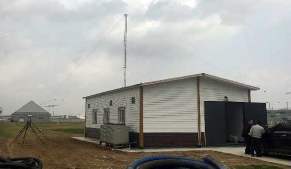
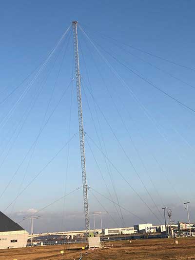
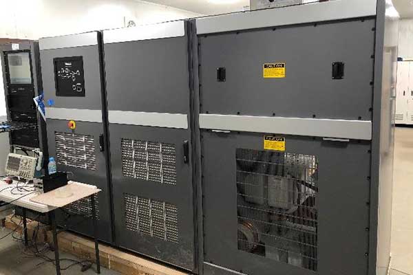
    UrsaNav provided, installed and tested an eLoran transmission system at a temporary location near Incheon, South Korea, in November 2019. The company also provided ancillary equipment for Additional Secondary Factor (ASF) map measurements and map-generation software, as well as differential reference station equipment to KRISO. Because of land size restrictions at the temporary site at Incheon, the eLoran transmission system was paired to a small footprint 35-meter top-loaded monopole antenna.

    In addition to the equipment provided by UrsaNav, MOF separately contracted a local Korean firm to provide an interim GPS receiver set to synchronize the existing Loran-C sites at Pohang and Kwangju to UTC.

    UN-1300 eLoran transmission equipment. (Photo: UrsaNav)
    UN-1300 eLoran transmission equipment. (Photo: UrsaNav)

    KRISO is in the early stages of measuring the performance of the Korea eLoran system, but results are expected to show better than 20-meter navigational accuracy within 30 kilometers of the differential reference station at the port of Pyeongtaek.

    Once the eLoran performance has been proven, MOF plans to move the Incheon eLoran equipment to a permanent site, potentially on the island of Socheongdo, and pair it with a larger “Tee” antenna to increase the output power and coverage area of the system.

    MOF also plans to upgrade the existing UTC synchronized Loran-C transmission sites at Pohang and Kwangju with new eLoran transmission equipment systems. The ministry will potentially add two additional transmission sites to provide complete coverage of the land and territorial waters of South Korea.

  • First South Korea government drone project completed with SimActive

    First South Korea government drone project completed with SimActive

    Photo: SimActive
    Photo: SimActive

    SimActive Inc., a developer of photogrammetry software, has enabled the first government drone mapping project in South Korea.

    Asia Aero Survey (AAS), a SimActive regional partner, used Correlator3D for the public survey delivered to the Korean National Geographic Information Institute (NGII) and the Korean Association of Spatial Information, Surveying & Mapping.

    While such projects were previously conducted using manned aircraft, a drone was preferred because of the difficulty in accessing the area of interest through traditional aerial and ground surveying methods.

    The NGII officially published guidelines for public surveying and mapping with drones in March 2018, with the AAS project being the first delivered and accepted as adhering to the new guidelines.

    AAS is also deploying UAV solutions with hyperspectral and lidar for other projects in conjunction with SimActive software.

  • South Korea defense agency selects SimActive's Correlator3D

    The Republic of Korea Agency for Defense Development (ADD) has selected SimActive’s Correlator3D software. The agency’s use of the software will include processing UAV and satellite imagery.

    SimActie-Correlator3DThe transaction was facilitated through a SimActive partner in the region, GeoFocus Inc.

    “The software was originally developed for military clients, which is reflected in the processing speed and rigorous mapping standards the technology adheres to,” said Philippe Simard, president of SimActive. “We are proud to welcome ADD as they join governments worldwide using Correlator3D.”

  • Europe EGNOS technology sold to South Korea

    Europe EGNOS technology sold to South Korea

    News from the European Space Agency

    Technology developed as part of Europe’s satellite navigation-augmenting EGNOS system has been sold to South Korea to serve its national equivalent system.

    Thales Alenia Space has signed a contract with South Korea’s space agency, the Korea Aerospace Research Institute, to supply ground infrastructure for the Korea Augmentation Satellite System (KASS) on behalf of the South Korean Ministry of Land, Infrastructure and Transport.

    EGNOS is Europe’s first venture into satellite navigation. EGNOS broadcasts augmented information through a trio of geostationary satellites linked to a network of monitoring ground stations, to sharpen the accuracy and reliability of GPS signals across the continent.
    EGNOS is Europe’s first venture into satellite navigation. EGNOS broadcasts augmented information through a trio of geostationary satellites linked to a network of monitoring ground stations, to sharpen the accuracy and reliability of GPS signals across the continent.

    The infrastructure is derived from that developed by Thales Alenia Space under contract to ESA and in its role as prime contractor for EGNOS, which has been operational since 2009 for general use and since 2011 for safety-of-life applications, including aviation.

    Designed by ESA and being exploited by Europe’s Global Navigation Satellite System Agency, EGNOS improves the precision of GPS signals over most European territory, while also providing continuous and reliable updates on the integrity of the GPS signals.

    A network of 40 ground monitoring stations throughout Europe performs an independent measurement of GPS signals, so that corrections can be calculated and then passed to users immediately via a number of geostationary satellites.

    The result is that the EGNOS-augmented signals are guaranteed to meet the extremely high performance standards set out by the International Civil Aviation Organisation standard, adapted for Europe by Eurocontrol, the European Organisation for the Safety of Air Navigation.

    Satellite Based Augmentation Systems (SBAS) such as EGNOS and the U.S. Satellite Wide Area Augmentation System (WAAS) operate by ensuring the integrity and positioning accuracy of GPS, as well as, in the decade to come, the European Galileo, Russian GLONASS and Chinese BeiDou systems.

    KASS is projected to be the ninth regional SBAS in service when it becomes operational at the end of the decade. The various systems are designed to be fully interoperable, ensuring air traffic safety as aircraft move between different zones, and jointly providing an almost worldwide service.

    Below is a video about EGNOS.

  • South Korea, Thales to develop SBAS for aviation

    South Korea and France’s Thales Group will jointly develop an advanced Satellite-Based Augmentation System (SBAS) for GPS by 2021.

    The country’s state-run Korea Aerospace Research Institute (KARI) will sign a $40 million deal with Thales Group on Oct. 26, according to the Ministry of Land, Infrastructure and Transport.

    The new SBAS, dubbed KASS (Korean Augmentation Satellite System), especially will help reduce errors in aviation GPS, which currently occur at a rate of one in 5 million and by up to 16 meters horizontally and 20 meters vertically.

    “By reducing the error and providing more accurate location of aircraft by using satellites, the SBAS is expected to help set the shortest air route possible while also helping reduce the cost of fuel for flights and thus expanding their capacities,” the ministry said in a press release.

    A separate agreement will be signed with the European Aviation Safety Agency to jointly verify the new GPS augmentation system following its development.

    KASS will rely on EGNOS (European Geostationary Navigation Overlay System) developed by Thales Alenia Space as prime contractor for the European Commission, with the European Space Agency (ESA) as contracting authority. The EGNOS system is operating in Europe since 2009 for Safety of Life services.

    South Korea will initially be using KASS to provide aeronautical applications, including Safety of Life services so that it can be used during different flight phases, especially landings. It will eventually extend these services to other applications, including maritime, road and rail.

    “Our first export success with this sophisticated and powerful navigation system is the upshot of Thales Alenia Space’s involvement with Europe’s satnav projects since the outset, in 1996,” said Jean Loïc Galle, president and CEO of Thales Alenia Space. “We are drawing on 20 years of experience to help the Korean space agency, and allow government bodies in the country to develop applications that will improve its people’s comfort and safety for all types of transportation.”

    Thales Alenia Space’s contract with KARI concerns the supply of the ground infrastructure. It will initially operate via a relay provided by an existing geostationary satellite, and it will be interoperable with other SBAS worldwide, which guarantee air traffic safety when planes move between different zones. KARI and Thales Alenia Space will be applying an approach based on partnership, which means that an integrated French-Korean team will be in charge of the project.

  • South Korea to build eLoran system after jamming incident

    South Korea will award a contract this month to secure technology required to build an eLoran system as an alternative to GPS, reports the Australian Broadcasting Company (ABC).

    The announcement follows South Korea pointing the finger at North Korea for jamming its GPS signal reception in late March.

    The South Korean eLoran plan envisions setting up coastal transmitters by the end of 2019, said Seo Ji-won, a government advisory panel member and professor at Yonsei University.

    “The need for us is especially high, because of the deliberate signal interference by North Korea,” a South Korean government official told Reuters, as reported by ABC.

    The latest jamming campaign from the North began on March 31. According to ABC, the jamming lasted nearly a week and affected signal reception of more than 1,000 aircraft and 700 ships, with the jamming originating from five locations along the border, South Korean officials said.

    GPS vulnerability poses security and commercial risks, especially for ships whose crews are not familiar with traditional navigation techniques or using paper charts. Vessels such as fishing boats lack backup electronic navigation systems.

    Air traffic was not usually affected because the GPS system is normally used as a backup in South Korea, not a primary navigation tool.

    GPS in the United States and Europe could also experience malicious jamming attacks, reinforcing the need for a backup alternative such as eLoran.

  • State Department issues notice on North Korean jamming

    On April 7, the U.S. Department of State issued a notice about the recent jamming experienced in South Korea.

    Korean Peninsula GPS Jamming Notice

    A continuing series of incidents have been reported in the general location of Incheon, Republic of Korea and the surrounding Gyeonggi and Gangwon provinces out to approximately 100 nautical miles beginning on or about 0000Z31March16.

    The nature of the events appear to be Global Positioning System (GPS) jamming emanating from the Democratic People’s Republic of Korea causing signal disruptions to airplanes, ships, and buoys in the area.

    Exercise caution when transiting this area. If appropriate, further information may be forthcoming. Vessels experiencing disruptions in the area are urged to report them to the point of contact (POC) below.

    The notice was forwarded by the U.S. Coast Guard Navigation Center’s Civil GPS Service Interface Committee (CGSIC).

  • South Korea issues warning over suspected North Korean GPS disruption

    South Korea issues warning over suspected North Korean GPS disruption

    South Korea issued a warning Thursday after detecting satellite signal disruptions that appeared to be coming from North Korea, according to the Korea Herald. The capital city of Seoul appeared to be the target.

    Officials said North Korea discharged a large amount of radio waves to jam GPS signals in the region.

    “We’ve detected signs that North Korea has been sending radio waves to the capital area since a month ago to disrupt GPS signals,” a senior government official said, speaking on condition of anonymity. “North Korea had been sending test waves since last month, but today, they discharged the largest amount.”

    The warning was issued at 7:30 p.m. in Seoul, the adjacent city of Incheon and the surrounding Gyeonggi and Gangwon provinces.

    The disruptions could cause mobile phones to malfunction and affect planes and ships that rely on GPS for navigation. No damage has so far been reported in the military or among civilians, officials said.

    Since 2010, GPS disruptions have occurred three times in South Korea, and all have been blamed on the North.

  • Army Gray Eagle conducts manned-unmanned exercise

    In August, U.S. Army Gray Eagle unmanned aircraft took part in manned-unmanned teaming exercises in South Korea, including streaming video and metadata to an AH-64 Apache helicopter while in flight.

    Exercise support was conducted from Kunsan Air Base, South Korea, and represent a milestone for the MQ-1C Gray Eagle, proving its ability to conduct operations in diverse weather condition, according to manufacturer General Atomics Aeronautical Systems (GA-ASI).

    During the exercise, the Gray Eagle UAS streamed video and metadata via a line-of-sight data link directly to the helicopter from extended distances. The Apache then retransmitted the imagery to a One System Remote Video Terminal (OSRVT), allowing field commanders within the Tactical Operations Center (TOC) to receive both live Gray Eagle streaming video and retransmitted video sent by the Apache. Once the Gray Eagle was airborne, U.S. ground forces passed contact reports and target coordinates to operators in the aircraft’s ground control station. The operators were then able to direct the Gray Eagle’s sensors to positively identify and track the targets.

    The Gray Eagle is used by the Army for reconnaissance, surveillance, communications, convoy protection, IED detection and precision weapons delivery.

  • North Korea Developing Precision-Guided Bomb

    North Korea is developing a GLONASS precision-guided bomb similar to the GPS-guided joint direct attack munitions (JDAMs) of the United States, reports South Korean newspaper The Chosun Ilbo (Korea Daily). 

    “We expect that the North will finish development of a new precision-guided bomb in the near future because we’ve detected signs that the North has been conducting tests for a few years now,” a military source in South Korea told the newspaper.

    The JDAM GPS-guided bomb has a range of 28 kilometers and accuracy of about 13 meters. North Korea’s new bomb is believed to have a range of 10 kilometers.

    According to The Chosun Ilbo, military authorities say they detected signs of a fighter jet dropping the bomb over a testing ground in North Korea’s Hwanghae Province earlier this year.

    The South Korean Air Force has a variety of precision bombs, including a device with a range of 100 kilometers.

    The JDAM kit is at the tail of the munition.
    The JDAM kit is at the tail of the munition.
  • Pacific PNT: GNSS, SBAS Updates

    The status of world GNSS, and augmentation systems in the Pacific region, highlighted the policy session of the Institute of Navigtion Pacific PNT Conference being held this week in Honolulu, Hawaii. Here are a few highlights:

    BeiDou-Logo-150x142BeiDou. Construction of the second phase of BeiDou has been completed; further launches for the third phase – constellation completion – are on hold until tests of the existing 14-satellite constellation are complete, according to Xiancheng Ding, Senior Advisor, China Satellite Navigation Office. As of December 27, 2012, BeiDou achieved full operational capability for most of the Asia-Pacific region. The full constellation is now expected to be completed by 2020.

    Other accomplishments include releasing the BeiDou Interface Control Document and manufacture of BeiDou chips for end-user applications. By the end of June, some manufacturers will release BeiDou chips in China, Ding said.

    Also in December, BeiDou introduced a new logo (at right).

    Yuanxi Yang (China National Administration of GNSS and Applications) presented statistics showing that BeiDou+GPS provides greater accuracy than GPS alone. For instance, the RMS of BeiDou+GPS kinematic positioning by using differential carrier phase is about 20 percent better than that of GPS alone, Yang said.

    By itself, existing BeiDou constellation system accuracy is better than 10 meters, timing better than 20 nanoseconds, and velocity accuracy is better than 0.2 meters/second.

    In all, BeiDou is composed of 14 satellites: five GEO, five IGSO, and four MEO. The full constellation (by 2020)  will consist of 35 satellites: 5 GEO and 30 non-GEO (a mixture of MEO and IGSO satellites).

    GPS. Keynote speaker David A. Turner (U.S. Department of State) shared his time with surprise GLONASS speaker Sergey Revnivykh (International Committee on GNSS, ICG). In his GNSS Policy and Program Update, Turner provided the dates by which three new civil signals will be on 24 GPS satellites.

    • The L2C signal is a developmental signal broadcasting from 10 GPS Satellites. It began launching in 2005 with GPS Block IIR(M) satellites, and is expected to be available on 24 satellites around 2018.
    • The L5 signal is a developmental signal broadcasting from three GPS satellites. It began launching in 2010 with Block IIF satellites, and is expected to be available on 24 GPS satellites around 2021.
    • The L1C signal begins launching in 2015 with GPS III; available on 24 GPS satellites around 2026.

    “We have an increasing number of signals, increasing capability, and increasing level of service as we continue to evolve the constellation,” Turner said.

    GLONASS. The next GLONASS satellite will be launched this Friday, April 26, Revnivykh said. This will be a GLONASS-M satellite, number 47. The first launch of a new generation GLONASS K satellite is scheduled for 2015.

    Revnivykh stressed GLONASS’ role as a global utility. “We consider international cooperation is essential for all GNSS, and we consider GLONASS an essential part of the international multi-GNSS system,” he said. He stressed the importance of compatibility and interoperability as key to this policy.

    In 2012, GLONASS performed with an average accuracy better than formally required, he said. GLONASS is in worldwide use, and positioning has improved by a factor of 10, from 35 meters to about 3 meters since the first satellites were launched. Using both GPS + GLONASS provides 1.5 times better high-precision measurements, Revnivykh said.

    The new GLONASS program for 2020 for GLONASS sustainment, development, and use includes GLONASS M, K1, and K2 satellites; the positioning accuracy objective is to go from the current 2.8 meters to 0.6 meters.

    Aviation. Chris Hegarty (MITRE) presented an FAA Navigation Programs Overview on behalf of the scheduled speaker Deborah Lawrence (FAA) who was unable to attend. He noted that United Airlines has begun GBAS operations in Houston.

    In answer to a funding question, he said, “The sequestration is not expected to have a positive effect on schedule, but the presented timeline for APNT is the FAA’s current best estimate. Congress has some tough decisions before them, and I wouldn’t want to speculate on potential schedule impacts. In the words of Yogi Berra, predicting is hard, especially when it involves the future.”

    Korean SBAS. Changdon Kee (Seoul National University) shared plans for a Korean SBAS. In South Korea, LPV availability is 49.4% compared to 90.6% in Japan. “Korea needs its own system,” Kee said.

    Phase 3 of the SBAS development could start by the end of September, depending on funding. It will include open service multifunctional GEO satellites interoperable with other SBASs. A pseudolite demonstration system will be completed in 2014, clearing the way for the beginning of Phase 3.

    In all, the system will include five reference stations, two master stations, two ground uplink stations, and two GEO satellites (the main GEO by 2018 and a backup by 2020).

    The Korean SBAS open service system will provide GPS L1 augmentation, begin operation in 2020, and support aviation, land and maritime users. A test operation system will provide GPS L1 and L5 augmentation. The system is expected to be fully operational by 2021, with service available throughout Asia.

    Michibiki-AlanJapan’s QZSS. Hiroyuki Noda (Office of National Space Policy, Japan) said three more satellites for this augmentation system will be launched by the end of the decade, with the service beginning in 2018. In September 2012, the Japan cabinet made the commitment to accelerate development of the system. The first satellite, launched in 2010 (QZS-1, aka Michibiki) is performing as expected.

    QZSS is expected to improve positioning availability from 90% to 99.8% in Japan. QZSS will not only improve positioning in the Asia-Pacific region, but is expected to improve the capacity to respond to natural disasters, Noda said.

  • Hyundai Heavy Industry to Track Equipment with Telit

    3.20.13_Taeha_TH- RMCU_ ANTENNA-1.jpgTelit Wireless Solutions will provide the M2M communication module for the Taeha Mechatronics Remote Monitoring System (RMS). Taeha Mechatronics is a South Korean-based provider of electromagnetic control solutions for healthcare and industrial devices.

    The Taeha Mechatronics TH-RMCU, a remote management control unit, integrates Telit’s HE910, HSPA+ module, which delivers 14.4 Mbps downlink data rates. The solution has obtained SK Telecom certification, and will be used for tracking the location of Hyundai Heavy Industry’s global assets. This is the first such authorization by SK Telecom for a system to be used locally and globally. As a result the device can be used in other countries simply by roaming without need for additional regional variants, Telit said. This move is expected to allow more Korean companies to operate more easily abroad.

    The HE910 supports a large number of WCDMA frequency bands (850/900/1700/1900/2100 MHz), making it possible for it to be used in all countries with 3G networks via simple roaming, with no need for production of regional variants to address local frequency band availability, Telit said.

    Hyundai Heavy Industry installs an RMS device, composed of the control unit and antenna, into various types of heavy equipment in the field. It uses the solution to trace equipment location with the integrated GPS which transfers the related data to a server in real-time. With that the company looks to prevent theft and loss of its assets. Also, with the monitoring function, the company can effectively manage fuel consumption of their equipment, actively using it to reduce carbon emissions, Telit said.

    HE910 is a RoHS-compliant module that combines GSM, GPRS, EDGE and HSPA+ network compatibility with digital telecommunication service access. It is world’s smallest (28.2×28.2×2.6 mm) LGA form factor, and ideal for applications that process high-capacity multimedia data, such as e-readers, PDAs and real-time location tracing devices. The HE910 HSPA+ transmission speed is 14.4 Mbps on the downlink, and 5.7 Mbps on the uplink. It supports high-speed serial port, receive antenna diversity, with optional embedded high-sensitivity GPS; and simultaneous voice and data.

    “Solutions developed solely by Korean companies needed to go through many different testing processes to be able to be provided to global customers. By adapting Telit’s standard-based module, we were able to not only reduce cost, but also reduce time for development. We are planning to expand the usage of this solution from location tracing for asset management to other areas,” said Sang-hee Lim, CEO of Taeha Mechatronics.

    “As the interest grows in security and safety globally, tracking solutions are also becoming smarter, in particular for the manufacturing industry, which uses various types of equipment. Companies can dramatically improve management efficiency and productivity simply by deploying cutting-edge monitoring systems. We expect to see continued demand for M2M,” said Derick Tsang, APAC manager of Telit.