If you’ve registered a commercial drone, the U.S. Federal Aviation Administration (FAA) wants to hear from you.
On June 19, the FAA sent a questionnaire to everyone who has registered a commercial drone – more formally, an unmanned aircraft system (UAS) — for anything but recreational or hobby use.
Most of these owners fly their drones for commercial purposes, but the survey population also includes government departments and other users.
Hobbyists are not included in this survey.
The goal is to collect information on drone flight activities under the FAA’s small drone rule (Part 107), data that will help the FAA improve the services it delivers to the UAS community. Responses to the questionnaire are voluntary and entered 100 percent electronically.
The survey will take about 10 minutes to complete.
The questions include areas such as number of drones registered, number and types of missions completed in 2017, primary locations where the operator flies and types of waivers requested. The survey also asks how operators want to get information about drone-related issues from the FAA, and how satisfied they are with the news channels they use now
The questionnaire is completely anonymous, so responses cannot be attributed to an individual.
If the questionnaire is still sitting on your computer or mobile device, the FAA wants — and needs — your input.
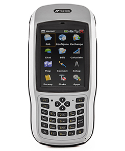
Topcon Positioning Group has introduced the T-18 handheld controller, which is designed to drive geopositioning, construction, mapping and vertical construction applications.
The controller includes a 3.7-inch sunlight-readable display with a 1-GHz processor, 1 GB of internal storage and up to 10 hours of battery life, the company said.
For data collection using Topcon’s MAGNET Field software, the T-18 controller offers a durable ergonomic solution with fast processing, a large screen, excellent connectivity and a long battery life.
Topcon MAGNET Field software offers a complete field solution for geopositioning professionals, enabling users to collect survey mapping data and perform construction and road layout using total stations, levels and GNSS receivers.
The T-18 features a 3.5G cellular modem for connectivity with Topcon MAGNET solutions for sending and receiving data to the cloud company account.
“The cellular option makes it easy to communicate with field crews when projects need to be changed or if important data is required back in the office. Additionally, the modem can be used for RTK (real-time kinematic) correction services,” Kerwin said.
Other key features include standard Bluetooth and Wi-Fi connectivity, as well as an IP65 rating for dust and water protection in demanding job site conditions.
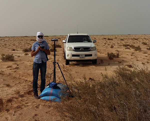
The Spectra Precision SP60 GNSS receiver has been selected to perform survey work for construction of a new 450-kilometer electric power transmission corridor.
Connecting Mauritania’s two largest cities, the capital Nouakchott and to the south Nouadhibou, the 225/90Kv transmission line parallels the Atlantic Ocean as it traverses the Sahara Desert.
The Mauritanian Electricity Company, SOMELEC, through its contracting company, awarded the sub-contract for surveying the transmission line and infrastructure to ETAFAT, a geospatial data acquisition and processing firm.
Difficult work conditions, including high heat (over 45 degrees Celsius) and the lack of existing control points were key factors in ETAFAT’s selection of the SP60 receiver. Because of the absence of existing benchmarks along the entire corridor, the SP60 RTX feature played a key role to ensure homogeneity in the coordinate reference frame between the two cities.
The RTX technology leverages real-time data from a global tracking station network with innovative positioning and compression algorithms to compute and relay satellite orbit, satellite clock and other system adjustments, transmitted to the SP60 via satellite or IP to deliver real time high-accuracy corrections, even in remote locations, the company said.
ETAFAT tested the SP60 data with RTX corrections and obtained consistently successful results. The geodetic survey was related to several ground control points (GCP) used in airborne survey. The measurement itself was conducted using two methods, dependently: the classical statistical method, and the RTK GNSS method. The SP60 met or exceeded the required +/- 15 cm order of accuracy.
According to baseline processing and adjustment reports, the SP60 delivered superior results under all conditions, and it did especially well under typical high temperatures of the Sahara Desert. Initialization was well within 5 to 10 seconds for RTK survey with radio signal coverage inside a 5 km radius.
As we approach the halfway point of 2018, one cannot help but notice the amount of technology that we use every day and how it affects our daily lives. While George Jetson isn’t whizzing by in a flying car to his glass condo in the clouds, we are utilizing an incredible amount of technology in normal life.
I can sit here typing on a computer or tablet that is many times advanced than the first one I used in junior high school and think nothing of it as futuristic technology has become the norm.
The old standard joke about technology used to be about cell phones and television remote controls; if you needed to figure it out, get your child or even grandchild to help. The youngsters were the majority that could embrace technology because they didn’t have past methods to confuse their ability to figure out how to work the new device.
A funny thing has happened along the way, though; those kids are now grown, and technology has advanced even further.
To help explain the names and timeframes of our generations, I found this chart that explained it all:
To help put this chart in context, the average age of the professional surveyor in the United States is 59 and solidly in the Baby Boomer category. But even with an average that high, there are still a significant number of surveyors in the Silent Generation as the economic downturn of the late 2000s has forced them to continue well into their golden years.
HOW SURVEYORS FIT IN THIS DISCUSSION
The surveying profession has suffered through the same generational challenge as the rest of society. The younger set that started out surveying with electronics have now graduated to much more complex yet capable machinery. Prior to the mid- to late 1970s, electronic technology did not play a role in most surveying operations and tasks. The professional surveyor was widely considered a boundary expert, map maker and establisher of topographic data, with the high-tech mapping work left to the government geodesists (see my July 2017 Survey Scene column).
Most surveyors who learned their craft prior to the electronic age were trained on the job or obtained an engineering degree through a program that may have offered a limited surveying curriculum. Surveying was a career for the outdoor type and required traversing rough terrain at times, as well as being able to withstand weather extremes.
THE NON-TECHNOLOGY GENERATIONS
As a second-generation surveyor, I was fortunate enough to have been exposed to land surveying literally as it was performed by our forefathers. While the tasks performed didn’t utilize a true Gunter’s chain and compass, they were completed with a modern transit and steel tape. The surveys we completed didn’t require high tech equipment as our manual procedures greatly exceeded commonly accepted positional tolerances.
A surveyor maps out boundaries for construction. (Photo: Bureau of Labor Statistics)
Most of the work performed by surveyors leading up to the early Baby Boomer generation was much simpler in theory but rarely easy to accomplish due to terrain, weather and the computations necessary to complete the boundary analysis. Traversing a parcel meant having a field crew of several people, often through brush and woods, and time consuming. A large parcel may be days or weeks of field to traverse around with most of it on foot. Once completed, the professional surveyor was tasked with often days of manual calculations, reduction of notes and determination of traverse closure. All the error from days of field work was then balanced through more hand calculations, usually by compass rule or transit rule, and hand drafted onto the final survey plat.
A similar story is followed with topographic and bathymetric surveys and creation of maps with existing conditions. Data collection performed to obtain locations and elevations of existing sites were by radial angle and distance or by grid method, with water depths being determined manually by use of lead lines. In the office this data is placed by manual drafting onto paper, sepia or vellum. Once elevations were plotted, contour intervals were determined by interpolation between each of these points. The creation of the contours was then drawn in by several methods, each with their own level of creativity by the drafter.
Because of the increased use and importance of electronic technology, data collection and advancements of the profession, today’s surveyor is faced with many more challenges than their predecessors. While the concepts for many tasks do follow the protocol for completing a multitude of survey duties, the way we go about collecting and analyzing the data is much more complex than in the past.
The need for our profession to identify these challenges and create opportunities for modern day surveyors is upon us, as our educational and training needs to be ramped up to stay current with demand. All professional surveyors, regardless of what generation they were born in, have filled or will fill an important role in society as expert measurers.
However, the rapid advancement of technology has exposed the lack of additional education and training necessary to keep our standing in serving the public’s health and welfare.
My point here is not that the work and tasks performed by past generations of surveyors was easier, but it did require more manual labor and less technical education and training. I liken the situation to automotive mechanics and how much more technology goes into working on a modern car versus vehicles of earlier generations.
Many mechanics tuned engines by “feel” with no recordable technology to tell them otherwise. I wouldn’t think of calling the expertise shown by past mechanics as inferior to today’s automotive mechanics; each has been trained to rely on different skills sets to work with completely different engines. Thus, I feel the same way in comparing different generations of surveyors. Different tools and methods require unique and specific training for the surveyor to perform at the highest level.
For example, look at the survey-related equipment, software and services within GPS World magazine; most of the articles, case studies and advertisements are for things not even considered five to 10 years ago. All these items require a different mindset of more technical and analytical processing, so the surveyor’s educational requirements and approach must adjust with the technology.
As time marches forward, the need for more advanced surveyors is reaching a critical point.
HOW TODAY’S SURVEYORS GET THE JOB DONE
Today’s surveying profession, including the field and office technicians, rely heavily on technology more than ever.
Many threads of advancing technology go into weaving the tapestry of modern surveying, with the primary material of GNSS being utilized throughout. I have written in the past regarding my thoughts on the single greatest advancement in surveying (see my May 2016 Survey Scene column) and my argument gets stronger with newer technology adding to the way we measure our world.
Here are some of the tasks in which the surveying profession uses GNSS as a basis of measurement and location, and why specific education and training is critical to proper execution:
Boundary surveys
Photo: Tim Burch
Like the surveyors before us, boundary establishment and re-establishment are the main responsibility of the profession. However, with GNSS, the ability to produce more location data has increased tremendously by reducing the need to perform intricate traverses through places when not necessary. It has also reduced the need to perform tedious traverse computations and adjustments; instead, least square adjustments are made to GNSS observational data to provide accurate results.
Topographic surveys
This data can be acquired by a combination of GNSS and conventional total station methods but is based upon geolocation information determined by primarily geodetic coordinates through GNSS solutions. Relying on GNSS data with no standard procedure for location and elevation verification can lead to major issues if not caught by an educated user.
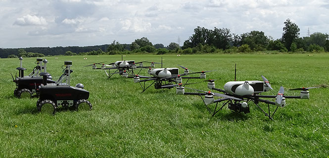
All these methodologies, also known as remote sensing, have revolutionized mass data collection with the enormous amounts of information that can be acquired in a short amount of time. Each has specific functionality and limitations but rely on geolocation as a main attribute of the data. Because of the large data files that are created, the output is in the form of a point cloud rather than the traditional P,N,E,Z,D format normally utilized by surveyors. Like topographic surveys, this data typically relies on GNSS information for geolocation.
Photo: Simon Batzdorfer, Markus Bobbe, Martin Becker and Ulf Bestmann
Unmanned aerial and terrestrial systems
The newest of the data collection methodologies, the unmanned aerial vehicle (UAV) has taken the surveying world by storm. A good percentage of the new adopters (including me) utilize commercial grade multi-rotor units coupled with a high-resolution camera for orthometric photos and video clips of project sites.
While this method uses photogrammetry as its data collection method, it relies on GNSS for establishing ground control points (GCP) to establish geolocation to a known coordinate system. Higher end models incorporate RTK units to minimize the number of control points as well as utilizing lidar and/or hyperspectral modules for high end remote sensing.
Along with the airborne variety, land-based unmanned vehicles are starting to catch on as additional data collectors of open, navigable terrain. These autonomous devices are being equipped with lidar and cameras to augment aerial data in concert with UAVs to gather redundant information for quality checks.
As stated above, these remote sensing technologies, whether used statically or on an unmanned system, all create large point cloud data files that can be cumbersome to manage.
Bathymetric surveys
Many advancements have been made in producing measuring devices using sonar technology, including side- and multi-beam models for more detailed observations in varying conditions. GNSS plays a big role in this survey method due to the electronic ability to combine the depth readings of sonar instantaneously with geographic location. This improvement in data collection provides much more accurate and reliable information for the mapping of water bodies and passageways.
Bathymetric surveys are also getting in on the unmanned vehicle program as well with shallow draft autonomous watercraft being used in places where regular bathymetric vessels cannot go for survey data. More of these crafts are being implemented as they become more affordable.
What do these categories have in common? Most rely on specialized training and equipment to perform each specific task. Surveying has evolved past a “one size fits all” situation and demands that each sector of surveying have personnel trained for the job and have the right equipment to get it done.
A central figure in all these tasks is also GNSS technology; from survey-grade receivers to UAV’s, the tasks all revolve around geolocation.
HOW DOES THE PAST COEXIST WITH THE FUTURE?
The modern-day surveyor now has many different tools at their disposal that generations of surveyors before us couldn’t begin to fathom. The ability to perform at such levels of production and accuracy using new equipment and software is incredible and humbling. However, I’m afraid the technology is outpacing the profession. How many surveyors have taken the time to educate themselves on these enhancements? Because I think we are stretching ourselves too thin, now is the time for the professional surveying community to pause for a self-assessment of our abilities and what it will take to catch up with reality.
One of the biggest hurdles the surveying profession is facing are the lack of qualified technicians for positions both inside and out. The recession of 2008-2011 reduced the number of technicians in our field due to the lack of work being done in the economic downturn, but it also came at a time when technology was starting its upward run at increasing survey task efficiency. The downturn forced many surveyors and firms to make drastic cuts and reduce their investment in new technology, equipment and training to be more efficient. The surveying profession is now paying the price for that downturn with few adequately trained technicians along with licensed professionals not staying current with technological innovation and advances.
WHERE DO WE GO FROM HERE…?
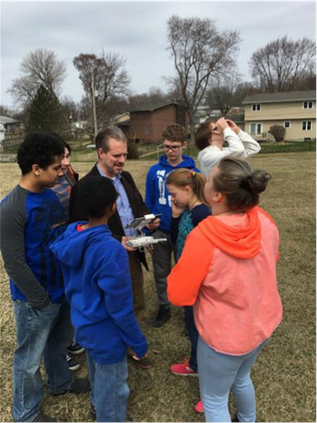
Tim Burch with seventh-and eighth-grade students.
The professional surveyor must embrace technology by promoting the profession to more places beyond the four-year college. We must start in junior-high and high school in math, science and history classes encouraging students to investigate surveying as a career. We also need to support technical and vocational programs that can help introduce surveying as a possible path beyond their certificate or associate degree. One of the simplest topics I use in presentations is the discussion of GNSS technology and how it is built into almost everything the student sees. From their cellphone to the cars their parent’s drive, GNSS surrounds us with geolocation information to make our lives easier.
These technicians aren’t going to all come from a four-year university programs; they are going to come from those teenagers who spend hours honing their hand-eye coordination with video games and drone racing. They will also be the fluid minds writing code for the next big app, and the surveying profession needs to embrace them to incorporate their work in our geolocation world.
The professional surveying occupation has become much more than establishing boundaries of parcels; it now requires knowledge for mapping literally anything in the world. The challenge now is to find those who want to help us continue this surveying and mapping tradition. Fellow surveyors: are you up to the challenge to find your replacement?
GEO Business, the United Kingdom’s largest geospatial exhibition and conference, has announced that registration is now open.
The GEO Business show has grown every year since its inception, and the 2018 show looks set to be the most successful show to date with more exhibition space and a brand new seminar program. The event will return to the Business Design Centre, in London, UK, May 22-23.
Since its record-breaking 2017 event last year, which welcomed 2,386 geomatics and geospatial professionals from around the world (a 48 percent increase since the launch in 2014), the exhibition has expanded onto the upper level. Exhibitors span the entire geospatial industry, showcasing cutting-edge technology and solutions that will mold the future of the industry.
The 2018 GEO Business show will expand to the second level of the Business Design Center. (Photo: GEO Business)
Confirmed exhibitors for 2018 include Survey Solutions Scotland, Land Registry, GAP Group, Phase One, Viametris, Surphaser/ MD3D, DHF Satellite and Ordnance Survey Ireland.
New for 2018 is a free-to-attend seminar program designed to demonstrate the remarkable impact geospatial technologies and solutions on the global environment. The program will feature case studies from companies demonstrating how they are reducing costs and risk while increasing productivity.
The 2017 GEO Business exhibit. (Photo: GEO Business)
The latest in augmented reality, building information management (BIM), geospatial information systems (GIS) and big data, laser scanning, mobile mapping, remote sensing and satellites, smart cities, surveying, UAVs, virtual reality and visualization will feature within the fields of architecture and construction, commercial property, environmental, equipment theft, floods, forestry, heritage, highways, hydrography, mining, rail and tunneling.
With geospatial technology now impacting on more and more industries, GEO Business is attracting visitors from a wider range of industry sectors than ever before.
“The geospatial industry is experiencing a huge transformation, everywhere you look at the moment you bare witness to the term ‘geospatial,’” Show Director Caroline Hobden said. “Innovative technology is steadily making its presence known in everyday life, whether it is through the revolutionary capabilities of augmented/virtual reality or the extraordinary data recorded by drones to name just a few, the world is sitting up and taking notice.
“Even the U.K. government budget made mention of geospatial at the end of last year and as a result we excitedly await further announcements about the Geospatial Commission whose focus will be on location aware technologies revolutionising the digital economy.”
The exhibition and seminar program will run alongside a strategic senior-level conference of invited speakers presenting and debating the role of geospatial in powering the Fourth Industrial Revolution, said GEO Business. The Fourth Industrial Revolution is changing how we live, work and communicate. It is reshaping government, education, healthcare and commerce — almost every aspect of life. The conference will celebrate, challenge and develop the role that geospatial has to play in maximizing the digital economy as part of this revolution.
Visitors will also have the unique opportunity to attend the well-established commercial workshop program hosted by exhibitors demonstrating their latest products and services and a full line-up of innovative social activities designed for informal networking with colleagues old and new.
The exhibition, workshops and seminars are free to attend. There is a fee-to-attend the conference with an early-bird discounted rate for registrations before April 16. Public sector, association members and student discounts are also available. Visitors are encouraged to register online in advance to beat the queues onsite.
For more information on stand sales or visitor registration, contact Caroline Hobden at [email protected] or call +44 (0)1453 836363.
Providing high-speed internet access to businesses and residences is a highly active and expanding field. It closely involves geographic information systems (GIS) to efficiently achieve fiber to the home (FTTH) or fiber to the premises (FTTP), the installation and use of optical fiber from a central point directly to individual buildings such as residences, apartment buildings and businesses for high-speed internet access.
A free webinar on Jan. 18 will cover — among several other related topics — the integration of high-accuracy aerial imagery into this process. David K. Nelson, GISP, a GIS manager in telecommunications for Black & Veatch, will make the presentation. It will be complemented by a talk on how to “Plan Virtually, Manage Efficiently with High-Definition (HD) Aerial Maps” by imagery provider Nearmap, and one on use of HD aerial imagery for city storm-water management.
David Nelson, GIS manager, telecom, for Black & Veatch
Nelson is responsible for developing GIS solutions for projects with the Black & Veatch’s telecommunications division. With over 13 years of experience in public and private sectors, Nelson is a visionary for adopting and enabling geospatial technologies and location content that drive operational efficiency. His presentation will cover such topics as GIS-centric approach for all projects; file-based vs. data-based transition; geospatial archives of all data; and integration with other technology platforms.
In a case study, he will take webinar attendees through a FTTH project design and execution example.
Black & Veatch is an engineering, consulting and construction company with more than 100 offices worldwide, specializing in infrastructure development in power, oil and gas, water, telecommunications, government, mining, data centers, smart cities and banking and finance markets.
FTTH project: fiber to the home. (Image: Black & Veatch)
The annual Black & Veatch Strategic Directions: Smart Cities & Utilities Report explores progress made across the smart city and smart utility landscape. This year’s report examines how modern, digital infrastructure is being used to optimize operations and create a sustainable future for our cities and utilities.
“From urban mobility to the proliferation of electric vehicles, transportation is changing rapidly, inviting opportunity in how people and goods move across cities. The next generation of wireless technology is upon us, further encouraging connectivity and enabling smart cities in myriad ways. Grid modernization continues as utilities work to create a customer-centric grid through a combination of smart devices, distributed energy and communications.”
Advances in aerial imagery including high-resolution maps and a streamlined process to capture, manage and deliver imagery in the cloud is transforming the way governments and businesses operate. With Aerial photography and instant access to current 2.8-in. GSD aerial views, Black and Veatch has increased efficiency in their telecommunications projects including assessment of ground conditions, construction and asset management. In Indiana, The City of Carmel’s Engineering Department has applied aerial imagery to enhance planning, operations and storm water management.
In this webinar, you will:
Learn about the latest advances in aerial imagery including how imagery is supporting a variety of government and business applications today
See real-world use cases of imagery in telecommunication, engineering and city government to improve operational efficiency
Understand how imagery can be used standalone and within GIS and CAD products
See the latest demos of Nearmap imagery including vertical, panorama and oblique views
As another holiday season passes us by, it is customary to look back at the year and recall the trends, new products and services, and breakthroughs we experienced with the GNSS environment and its effect on the professional surveyor. While 2017 was not filled with groundbreaking instruments and programming, it did provide a good look at what are going to be trends and gamechangers for the near future. From new innovations on GNSS receivers, new UAV platforms, and geospatial advances, it was also a year that saw location spoofing of shipping vessels, trade relations among super powers being tested, and more opportunities to put satellites into orbit from the private sector. Let us look back at what the surveying community experienced with the GNSS industry:
The constellation scorecard
GNSS continued to expand to all reaches of the globe with enlargement of existing constellations along with introductions of several new ones, (see GPS World magazine “The Almanac,” December 2017). The European satellite system, Galileo, has led the expansion with four (4) new vehicles. This joint venture of the European Commission and the European Space Agency was declared operational at the end of 2016 and looks to keep increasing its coverage in the coming years. For surveyors, this means additional redundancy for our positional data. More confirming redundancy translates into increased confidence in our work product.
Next in numbers of vehicles being sent to space is the Japanese effort named Quasi-Zenith Satellite System (QZSS) and operated by the Japan Aerospace Exploration Agency (JAXA). While their first bird was sent up in 2010, this was the breakout year with three (3) more satellites installed this past year. It is anticipated that the constellation will be operation in 2018 and we can expect most of the GNSS manufacturers to include the positional data from QZSS if they haven’t already built in this capability.
Coming in next are the Chinese with their regional-based system called BeiDou with two (2) more satellites installed in 2017. Their current program is scheduled to have several more vehicles included in the constellation and provide worldwide positional coverage by 2020. With the rapid expansion of China as a world leader, we can anticipate more GNSS developers to work closely with BeiDou as the system becomes more effective on the global stage.
The other world leader, Russia, continues their expansion of GLONASS with the installation of one (1) new satellite in 2017 with plans to upgrade several existing vehicles in the coming years. The inclusion of GLONASS signal reception by survey-grade GNSS receivers has greatly increased the redundancy of data collection, (as mentioned with Galileo). It has also expanded our timeframes in which we can work with reliable positional solutions, thus keeping our downtime to a minimum.
The United States is by no means bringing up the rear in GNSS constellation development but 2017 was a transitional year for the program. A new government administration has led to revisiting our national budget, with the Department of Defense looking to prosper under preliminary plans. While the schedule for constellation expansion have been in place for several years, the installation of Block III satellites has become a higher priority. These satellites will provide higher positional accuracy than previously experienced without any correction signal utilized. This will help the surveyor with better positional accuracies in shorter timeframes and looking forward to its expanded capability.
Once these constellations are operational (with more to come), the ability to record positional locations and attribute data will be greater than ever. A potential challenge to these satellite constellations, however, is the ever-growing fear of potential conflicts between the United States and several countries, including North Korea, Syria, Iran, and Russia. The threat of nuclear war with North Korea could result in our GPS network being shut down to civilians or blocked by an electromagnetic pulse weapon. Cold War tactics with Russia could lead to spoofing or blocking of GLONASS signals that many of our GNSS receivers have become reliant upon. There are alternatives being developed in case our GPS goes away (see “The Day GPS Went Away,” September 2017) but we are several years from having a true secondary option. We will need to keep our fingers crossed we can maintain peace across the globe but do not look forward when something happens and takes our GNSS ability away.
Data mining and the surveyor
One thing that has emerged from 2017 has been the importance of data; where it is housed, how we use it, and what it can tell us about our future endeavors. GNSS has revolutionized the data mining industry with the surveying industry being right in the middle of the fray. Prior articles were published about geolocation (see Geolocation and the surveyor: Looking back to the future) so the rapid expansion of the data collection into most business environments shouldn’t surprise most readers, especially if one reads technical sources like GPS World magazine. The surveying community has watched and experienced the astronomical growth of this data collection in various arenas, none of which was more obvious than the “Geospatial 4.0” initiative at Intergeo 2017 in Berlin, Germany. While summarizing to readers on a trip through the annual conference in the last article (Intergeo 2017: A surveyor’s perspective), it was also here that a bigger picture was coming into focus regarding data and its effect on our world.
While doing homework for this article, the term “Geospatial 4.0” was coined for the 2015 Intergeo conference in Stuttgart, Germany. This term was developed by the conference team regarding the advancing developments in the data world that incorporate geolocation, time, and unlimited information attributes, all while stored in a central location “in the cloud.” This environmental condition exists for most us already, as it is estimated there are three to four billion smartphone users worldwide. The data that is being collected every day is a small part of how our lives and relative actions have become digital snapshots to assist those charged with forecasting and planning of our future cities and environments. Much of this data is being used to advance the places where we live through an initiative called “Smart Cities.” Installation of data collection sensors and control systems in various applications monitor and store information to help make necessary changes to the existing systems. The organizations and municipalities behind this effort are attempting to create better work and home environments with increased efficiency and sustainability.
The professional surveying community plays a big part in the continuing development of geospatial world around us. Our job is not only to collect data for a boundary survey, topographical information for an engineering design, or provide layout assistance for construction; we are also historians in establishing the current positions of required information at a specific point in time. The world around us can move quickly, so providing the precise moment in time when data is collected is sometimes just as important as the location itself. Our role as surveyors becomes even more important as the increased development and implementation of geographical information systems (GIS) emerges within more public and private entities. Where the surveyor previously shunned being included within the collection process and framework of GIS, our profession has become quite efficient at the data acquisition and database maintenance necessary for geospatial success.
The surveyor’s friend in the technical world of geodesy, the geodesist, has not always been an accepted member of the GIS world, either. Once seen as mathematicians stuck in laboratories calculating “perfect world geometric solutions,” the geodesist carries a significant amount of beneficial information to the realm of geospatial data. It has been through their data collection and research that has brought our shifting continents to light and the simple fact our land-based coordinate systems must be modified to change positions as time rolls along. The common theme here is that spatial data comes down to several distinct factors: position, navigation, and time.
PNT (not just another dull government acronym…)
Another big step forward taken in 2017 was the continued implementation of positioning, navigation, and timing, otherwise known as PNT. These three bits of information provide the geographic basis of collected data for any GIS or other environmental study. According to the U.S. Department of Transportation website, here is the definition of PNT:
“…a combination of three distinct, constituent capabilities:
Positioning, the ability to accurately and precisely determine one’s location and orientation two-dimensionally (or three-dimensionally when required) referenced to a standard geodetic system (such as World Geodetic System 1984, or WGS84);
Navigation, the ability to determine current and desired position (relative or absolute) and apply corrections to course, orientation, and speed to attain a desired position anywhere around the world, from sub-surface to surface and from surface to space; and
Timing, the ability to acquire and maintain accurate and precise time from a standard (Coordinated Universal Time, or UTC), anywhere in the world and within user-defined timeliness parameters. Timing also includes time transfer.”
The basis for PNT can be used for any data collection. From fixed monuments utilized by surveyors to any municipal utility installation, the use of PNT now becomes an important part of the GIS database, if not for anything more than simple tracking. By establishing the location of any entity at any given time and comparing its position to an earlier collection, we can determine the navigation of that entity. A good example of PNT and our daily interaction is the satellite navigation systems installed in our phones and vehicles. When we utilize our favorite mapping program on our phone or in our car, we are implementing a PNT system to show us where we are, how fast we are going and help determine how soon we will be getting where we are going. This wonderful practice is being made possible by GNSS data collection and computer processors turning the positional data into useful information.
Surveyors are doing the same thing by the data collection they are performing every day. Any data that is collected by a modern survey instrument is being tagged with two of the main components of PNT; position and time. When the same entity is collected again later, its navigational information can be determined if needed as well. This type of data collection is becoming more apparent with laser scanning and lidar point clouds, as this data can be revisited to determine how much entities within the project area has changed. I foresee a time in the not-to-distant future where much of the Earth is scanned for historical purposes and can be analyzed by future generations for changes. A surveyor could benefit greatly by knowing where a water feature (rivers, creeks, streams, and lake and ocean shores) existed at a specific point in time and how much it has changed over time. Many land boundaries are based upon these water features as natural delineators, so knowing how much title area has changed with the natural movement of a waterway would be very beneficial to the surveyor and how land boundary disputes are handles. Same could be said of buildings and other improvements within developed areas, too. By establishing geospatial data on physical improvements, it could greatly help the surveyor determine historical and future land boundaries by their known location.
The simple fact is that our ability to collect, analyze and retain geospatial information has never been greater than now and only gets better over time. The surveyor now has similar tools to other sciences and technologies, so now is an appropriate time as any to truly embrace geospatial data collection.
UAV’s continuing growth
One market that continues growing at rapid pace is the unmanned aerial vehicle (UAV) sector. 2017 brought more aircraft innovations and expansion of sensors available for a multitude of data collection purposes. This greatly expanding segment of specialized equipment was quite evident at Intergeo 2017, where over 150 UAV vendors were provided their own space solely for the exhibiting as well as an outside arena for demonstrations. While there are other UAV trade shows that rival in the size, the Intergeo show brings the best vehicles, software and ideas for geospatial data collection and imagery directly to the surveyor’s hands.
Other innovations that are taking shape in the UAV world include larger multi-rotor aircraft with increased payloads, vertical takeoff and landing (VTOL) platforms, and a plethora of sensors designed specifically for UAV use. These modules include various methods of lidar for high accuracy scanning, hyperspectral cameras for analyzing plant characteristics, infrared scanners for heat detection, along with camera possibilities that are endless. The main reason to highlight these high-tech applications is simple; these technologies consist of location-based data collection. The surveyor, known professionally as the expert measurer, should make themselves more aware of the rapidly expanding ability to collect data of varying types new to the land surveying field but still relies heavily on accurate and precise measurement methods. The UAV, while still new to many surveyors, is becoming a standard measuring tool in our world. These latest sensors are a result of applying emerging technology for non-traditional surveying clients directly into our wheelhouse. The professional surveyor successfully adapted to new methods and instruments when electronic distance meters, GNSS receivers and laser scanners were introduced, so our profession needs to step up again and take note of what data collection methods and challenges are out there.
Wingtra One in the air. (Photo: Wingtra)
Staying on the subject of surveyors and the UAV, one of the next breakthroughs will be the introduction of affordable aircraft with RTK capability. There are currently several manufacturers of survey-grade UAV aircraft but these are sold at higher price point that is considered out of reach for the typical surveyor. Many have relied on less expensive models in conjunction with their existing RTK receivers to collect physical points or features for use with post-processing software. While not resulting in immediate data for project review, the end product of the post-processed method is quite good and at much lower cost of entry. However, there are times and places where ground control is not available or accessible so flights with photos or scans are not possible. The mainstream UAV manufacturers are taking note of the need for RTK capability and beginning to introduce models with this positional feature, so maybe the tide is turning to lowering the price point for this technology as well. Here is another place the surveyor will need to enter the UAV arena as the long-time RTK expert and utilize the latest technology for expanded data collection purposes. To my fellow surveyors: you’ve been warned, so be ready to get your checkbook out in order to stay competitive.
Survey-grade GNSS receivers
While 2017 wasn’t a breakout year for radically new GNSS technology, it did see its share of minor yet significant improvements. Along with the expansion of existing constellations and preparation for new ones, the technology behind the microprocessor within the GNSS receiver continues to allow for miniaturization and increased speed and accuracy. Several manufacturers are producing survey-grade receivers capable of acquiring hundreds of GNSS signals yet fit in the palm of your hand. Batteries, like most technologies using it, continues to decrease in size yet gain in power-up time. This rapidly shrinking footprint of the GNSS receiver is allowing for placement in more devices and places so the surveyor will need to take advantage of these gains to assist with providing positional and data collection expertise.
A sector of the positioning market that will see rapid increases is the smartphone division. Coupled with the growing GNSS constellations with increasing accuracy signals and more sophisticated computing power programmed specifically for positioning, we will see more smartphones being used for data collection purposes. Google has made significant strides in the customization of the Android operating system to allow for the processing of raw GNSS data to provide positional accuracies beyond the normal smartphone capability. It is safe to say that Apple is likely working on the same type of application for the iOS operating system, so we could see another battle for smartphone supremacy be waged on a highly technical front that surveyors can readily use for their profession.
Another advancement in GNSS technology that will see more in 2018 and beyond will be the use of the inertial measurement unit (IMU) in conjunction with receivers and sensors. Several manufacturers have incorporated IMU’s into their measuring devices to augment the data being collected. The application that has surveyor’s attention is a GNSS receiver with an IMU to record the measurement correlation of the pole tip to the center of the antenna. The IMU has also been configured on various vehicles built for mobile data collection to measure velocities and acceleration to assist with reducing errors within the GNSS measurements by environmental factors. As GNSS receivers continue to evolve and reduce in size, it will also allow for further inclusion of an IMU to help with reduce data errors. Surveyors should take note of these advancements and be prepared to upgrade their equipment and knowledge to stay current with emerging technology and data collection accuracies.
VectorNav’s new Tactical Series includes the VN-110 IMU/AHRS, the VN-210 GPS/INS and the VN-310 dual-antenna GPS/INS.
Into 2018 and beyond…
Some of the items worth watching in the immediate future include:
Autonomous travel
From Elon Musk’s Tesla projects to the Uber/Volvo collaboration with driverless vehicles, autonomous travel will dominate tech news for the next few years. Because these vehicles rely heavily on GNSS positioning in conjunction with road-reading sensors, the focus on the GNSS constellations will stay very much in front of the tech and political worlds. Another portion of the driverless equation is the effective mapping of the roadway system, which come right back into the realm of the surveyor. While we see various mapping vehicles (Google, Apple, and others) out and about digitizing our roadways, the surveyor is the professional entity that is relied upon for the location establishment for existing and future rights-of-way. Our inclusion in mapping these byways is critical to minimizing harm to the public for potential accidents and disasters.
Lightsquared 2.0
The battle over bandwidth several years ago seemed to end with the FCC denying the implementation of ground-based signal amplification by an upstart firm known as Lightsquared. Now with the new administration at the FCC and an atmosphere of deregulation, the firm has rebranded itself as Ligado and is back to try again. Hopefully the same coalition that helped defeat the prior attempt will be back, but with the new ideology running the FCC, all bets are off. The surveyor without GNSS capability (as previous discussed) will mostly be rendered lifeless without it.
Internet of Things (IoT)
Also fighting for bandwidth is a new generation of sensors and monitors being used for a multitude of products and procedures. This movement toward automation is proving to be useful in many environments but is beginning to tax an already overworked data stream. These components are more appropriate in mostly urban areas where broadband coverage is most effective but their implementation in rural America is starting to drive a greater need for more data availability in harder to get places. This push to get more broadband into rural areas will be a wonderful opportunity for those surveyors to complete their projects with similar effectiveness their counterparts in the urban areas already utilize. But the move by the FCC to repeal net neutrality poses a significant threat to that opportunity and equality, so we must wait and see how this plays out as well.
Final thoughts…
While covering a lot of ground here, the main thread is to emphasize the important link between the professional surveyor and the use of GNSS equipment and procedures. Prior to most of the emerging technology, the surveyor was relied solely for boundary determination and not much else. As engineering design became more reliant on detailed topographic surveys, the surveyor increased their responsibility to provide that vital information. As measuring and positional determination has become more complex, the surveyor has adapted to technology and provided that expertise in their duty to protect the public’s interest. Our world is getting more complex every day and we rely on specialized professions for a multitude of tasks. The surveyor can and should be relied upon for tasks discussed herein but making sure both the surveyor and the public knows that is a big key to success. Accurate positioning and reliable measurements requires someone with the knowledge of the subject and technology and the professional surveyor is that someone. To my fellow practitioners; stay involved, advance your education, and continue to be professional.
Kespry now offers a suite of capabilities that extends the value of aerial intelligence to the full life cycle of planning, bidding and managing earthworks projects in the major site construction industry.
The company is focused on making it easier to capture, process, use and share high-resolution information from the field with its fully autonomous aerial intelligence system.
Capabilities include grade planning and analysis, site and surface comparison including cut/fill visualization, and design plan development and compliance.
Compared to other drone mapping solutions, the earthworks-specific tools enable construction companies to more accurately plan the work, improve their cost structure, and deliver safer working environments through frequent analysis of changes to the site, according to Kespry.
The new capabilities are a result of customer and partner feedback, including from John Deere, dealers and clients.
The new earthworks capabilities provide:
Faster and more accurate production of earthwork grading plans through on-demand drone data capture and analysis. Mass haul plans can be easily developed before projects begin with an entire site mapped and analyzed in hours. New tools also enable haul road planning to support more efficient site planning.
Reduced costs for grading project bids, with project estimates delivered faster than with traditional estimating techniques. Ongoing operational costs are also reduced with on-demand cut/fill analysis enabling close management of the project and specific bid requests.
More efficient and safer project operations with progress comparisons delivered through daily drone flights. This enables design plan comparison through project plan overlay onto Kespry data, reducing the complexity and cost of rework. Safety can also be improved through close monitoring of change and analysis of grades around the site.
Protects critical infrastructure from spoofing and jamming
The BlueSky GPS Firewall is designed to provide security protection for GPS-delivered position, navigation and timing (PNT) data. It can be deployed in-line between any standard GPS antenna and stationary GPS receiver to provide protection against GPS signal incidents, both intentional or accidental, before they enter a GPS receiver system. BlueSky GPS Firewall filters the GPS signal in real time, removing anomalies before the signal is consumed by the downstream GPS receiver. This creates an intelligent and secure barrier against jamming and spoofing, and prevents the GPS receiver from being impacted by such incidents. It incorporates an Ethernet interface for remote management and monitoring and includes a secure web interface for configuration and set-up. Evaluation kits are available in advance of full production release, both in response to the growing number of GPS incidents and their potential threat to critical infrastructure.
Four new models of high-performing wideband low noise amplifiers (LNAs) are now available for choke-ring antennas, with options of 35-dB and 50-dB gain. The LNAs are designed for upgrading existing choke-ring antennas with Dorne Margolin/EDO elements to receive new and expanding GNSS signals. The LNAs provide consistent gain across the full bandwidth and include filters for suppression of out-of-band interfering signals, such as cellular LTE and Iridium signals, while maintaining a low noise figure, high third-order intercept point, small group delay and low power consumption. The enclosure is designed to fit a wide variety of currently deployed choke-ring antennas.
OEM boards for high-precision guidance and control
The BD GNSS family of boards includes the BD940 GNSS and GNSS-inertial boards and new BD990 GNSS, GNSS-heading and GNSS-inertial boards. The BX940 and BX992 models are available in a rugged enclosure (pictured) for applications in harsh environments. The BD GNSS boards offer simple connectivity and configuration, allowing system integrators and OEMs to easily add GNSS positioning and orientation — with the ability to upgrade its capabilities — using the same board footprint, connectors and software interface for specialized and custom hardware solutions. The compact boards include a broad range of receiver capabilities, from high-accuracy GNSS-only to full GNSS-inertial features for positioning and 3D orientation. Firmware options are upgradeable, allowing functionality to be added as requirements change. The boards are designed for UAVs, autonomous vehicles, fleet management and aviation.
The Precis-BX306 RTK board (pictured: Precis-BX306 board easy kit) has been upgraded with new and improved GPS and GLONASS functionality. The new version supports up to 20-Hz real-time kinematic (RTK) solution and raw measurement output, which can be integrated with autopilots and inertial navigation units. With improved algorithms, the new Precis-BX306 demonstrates an ability to quickly fix a 30-km baseline. Stable fix rate is achieved when under tree canopy, in urban canyons and other challenging environments. This latest version of Precis-BX306 is pin-to-pin compatible with major GNSS boards in the market, offering a flexible interface. Event mark and PPS are supported as always.
Offers advanced radio connectivity with GNSS receivers
The R4S-BT UHF radio provides an external option for use with the Sokkia GCX receiver line. The UHF multichannel radio modem has a tuning range of up to 70 MHz. It features an IP67 certified housing with internal batteries designed to be easy to carry with versatile mounting options. The radio modem makes the GCX GNSS receiver a more scalable and modular solution for situations without a network connection or when long-range Bluetooth technology is not enough on its own. Survey and mapping professionals can add the radio modem to extend the range between the base and rover. Connectivity options include wireless data transfer and USB connections.
The Triumph-F1 Survey UAV and Receiver is based around a geodetic GNSS receiver with 864 channels. When used on the ground, the receiver can function as base or rover. It includes eight propeller motors, a sim card slot, two micro SD card slots, USB connector, satellite tracking and communications indicators, flight and gyro status indicators, storage and selector for saved flight patterns, up to four antennas including Bluetooth and Wi-Fi, four angled cameras and a downward-facing high-precision camera for photogrammetry.
The S321+ and C321+ smart antennas are upgrades to the previous versions S321 and C321 and offer added benefits. Powered by the Eclipse P326 OEM board, the smart antennas support 394 channels and can simultaneously track all satellite signals including GPS, GLONASS, BeiDou, Galileo and QZSS. The boards come with two hot-swappable lithium batteries providing up to 12 hours of operation. The S321+ and C321+ combine Hemisphere’s Athena GNSS engine and Atlas L-band correction technologies with a new customer-friendly web user interface. Both antennas meet IP67-standard requirements. The S321+ and C321+ come in two versions, with 4G LTE optimized for either North American or international locations. The S321+ is designed for use in land or marine survey, GIS, mapping and construction. With the SureFix advanced processor, the S321+ delivers high-fidelity RTK-quality information. The C321+ is designed for construction environments, and can be paired with Hemisphere’s SiteMetrix software that helps manage construction jobsite activities.
Integrates data from a variety of sensors in one platform
X-PAD Office Fusion is an all-in-one office software combining data from multiple sensors into a single interface. It manages, combines and processes data from GNSS receivers, total stations, laser scanners and other sensors, whether from GeoMax or another provider. There is no need to export the data from one program to another, and X-PAD also offers all CAD features. The program handles a multitude of different types of data: measurements, coordinates, drawings and point clouds. Large quantities of data can be managed in the fastest way with maximum accuracy. The software automatically detects the common points between the point clouds and performs a first rough alignment. The Bundle Adjustment feature performs the final and accurate alignment in order to reduce errors. Personalized reports are then created with little effort.
The TSO Public Tracker provides public transportation riders with a variety of GPS-based monitoring capabilities. Riders can view exact locations and information on a variety of public vehicles. Passengers can view on a single screen the whereabouts of connected-fleet vehicles in real time. The tracker can be used by agencies of all sizes and in different geographical locations. The related TSO Mobile App provides route information, current and historical location updates in different map views through Google Maps, and more. TSO Mobile’s transportation solutions also provide agencies with driver reports based on customized behavior metrics to improve driver behavior.
Omnitracs Virtual Load View (VLV) provides brokers, shippers and carriers with direct access to the position data of assets carrying their freight, allowing them to easily track loads. Position data about the load is either shared from the Omnitracs Intelligent Vehicle Gateway (IVG) or Mobile Computing Platform (MCP) unit, or if no Omnitracs unit is available, through the VLV Mobile smartphone application, which the driver can download from the iOS and Android app stores. VLV can also be directly integrated into a company’s back office system, so employees are not required to learn and access a new platform. Brokers and shippers can identify loads that are behind schedule so they can make the proper adjustments in a timely manner.
The lightweight fixed-wing UX11 UAV combines a powerful integrated onboard system, industry-grade sensors, limitless communication range and PPK centimeter-level positioning. It carries enough onboard computing power to access and process pictures, then send them to the operator in real-time. It will run automated quality checks on the images (such as blur detection or overlap checks) to help ensure the operator is acquiring quality data. Its redundant communications system includes a proprietary line-of-sight radio and 3G/4G connectivity between the ground-control station and the UAV using a worldwide machine-to-machine pre-paid plan. The UX11 is ready for beyond visual line-of-sight (BVLOS) flights with unlimited range and adds a new level of safety with this communication link.
Super 35 Camera for Professional Aerial Cinematography
The Zenmuse X7 UAV camera features superior image quality, interchangeable lenses and a new post-production color system. The Super 35 digital film camera is designed to work with the DJI Inspire 2 drone. The Zenmuse X7 features 14 stops of dynamic range for more detail in low-light conditions. Its low-noise image capture enhances grading flexibility by preserving details in both highlight and dark areas while enabling a shallow cinematic depth of field. It is capable of shooting 6K CinemaDNG RAW or 5.2K Apple ProRes at up to 30 frames per second (FPS), as well as 3.9K CinemaDNG RAW or 2.7K ProRes at up to 59.94 FPS to integrate into industry-standard post-production workflows.
The Atlas NEST smart protective charging station is designed for autonomous beyond visual line-of-sight (BVLOS) operation of the Atlas Pro drone platform. The Atlas NEST is a landing, protective charging station that extends flight range and provides constant drone readiness in remote locations. When the Atlas Pro UAV requires new batteries, it can autonomously land in a NEST charging station where a robotic arm changes the drone’s batteries, allowing the Atlas Pro to continue flying to mission completion. The Atlas NEST can be stationary or motorized.
VTOL lift-off followed by tilt to fixed wing in flight
The WingtraOne vertical take-off and landing (VTOL) UAV bridges the gap between traditional multi-rotors and fixed-wing drones. It takes off and lands vertically like conventional multirotors, but once in flight, the drone tilts forward to fly like a fixed-wing aircraft. Being able to carry a heavy payload such as the Sony RX1RII, the drone offers high mapping accuracy, while covering an area of 980 acres (400 Ha) at 3 cm/px (1.2 in/px) GSD or the equivalent of 570 football fields. The WingtraOne is available in use in Europe, China, the United States and Australia for applications ranging from surveying and precision agriculture to glacier monitoring.
Commercial drone-maker Delair has introduced a professional unmanned aerial vehicle (UAV) for survey-grade photogrammetric mapping.
The UX11 is a small fixed-wing UAV that combines a powerful integrated onboard system, industry-grade sensors, limitless communication range and PPK centimeter-level positioning. It carries enough onboard computing power to access and process the pictures, then sends them to the operator in real-time.
According to the company, it will run automated quality checks on the images (such as blur detection or overlap checks) to help ensure the operator is acquiring quality data.
The UX11’s redundant communications system includes a proprietary line of sight radio and 3G/4G connectivity between the ground control station and the UAV using a worldwide machine-to-machine pre-paid plan.
Building on Delair’s experience with beyond visual line of sight (BVLOS) operations since 2012, the UX11 is ready for BVLOS flights with unlimited range and adds a new level of safety with this communication link.
The UX11 is lightweight, ultra-stable, simple to hand-launch at takeoff and it lands precisely where planned using distance measuring technology. New user-friendly Android mission planning software boasts innovative features such as support for in-flight camera feedback and live data review, the company said.
Made to help professionals in GIS, survey, and construction optimize area coverage per flight, the UX11 flies for 59 minutes with the best coverage and resolution specifications in its class for flights at 122 m (400 ft) altitude above ground level. The UX11 will be available for purchase via DELAIR’s global network of distributors by January, 2018.
The UX11 is a product offer for data acquisition which can be complemented by data processing and analytics software programs to address a range of commercial applications. Geospatial users can create 2D and 3D models and then generate elevation profiles, contour lines, slope qualifications and volumetric estimates with high accuracy and resolution using post-processed kinematic data and ground-control points.
Leica Geosystems has released the Leica GS18 T, a fast GNSS RTK rover, as well as the latest versions of Leica Captivate field software and Leica Infinity office software.
Leica made the announcement at Intergeo 2017, held Sept. 26-28 in Berlin, Germany.
The announcement expands the Leica Captivate Experience. With the addition of calibration-free GNSS and various upgrades to the Captivate field software and Infinity office software, users continue the immersive experience with self-learning GNSS and engaging, intuitive software interfaces.
“In my business, speed is the name of the game,” said Manny Sangha, owner of Sangha Geomatics & Land Survey Inc. in Vanderhoof, Canada. ” With my GS16, I’ve been able to reduce time spent on every project. I can only see this getting faster and improving efficiency with the GS18. No longer having to level the pole nor calibrate the system, this is a real value for me and a game-changer in the industry.”
Calibration-free tilt compensating GNSS
According to Leica Geosystems, the GS18 T is the a calibration-free tilt compensating GNSS solution immune to magnetic disturbances.
GNSS measurements can be taken from any position on site, saving users up to 20 percent of time in the field over conventional surveying practices, because they no longer need to hold the pole vertical to level the bubble.
The GS18 T uses precise inertial measuring units (IMUs) and not a compass, so that users can measure with a tilted pole close to buildings, underneath cars and close to metallic objects.
With integrated quality assurance, the GS18 T records exactly how the pole was leveled during the measurement. The GS18 T then stores the values, ensuring measurement traceability and complete quality reporting.
Software updates
Fully supporting the GS18 T, Leica Captivate v3.0 field software and Leica Infinity v2.4 office software now offer users a more immersive means of control on site and at the desk.
Captivate now allows configuration of the GS18 T for all measuring and staking applications and the visualization of tilt compensated measurements. Measured data can be directly imported into Infinity or exported into a variety of formats suitable for CAD packages.
Within Infinity, users can visualise the measured data, including the creation of reports providing full traceability and quality assurance for themselves and their clients.
Hexagon AB showcased its geospatial and construction portfolio at Intergeo 2017 in Berlin, Germany.
Hexagon’s sensor portfolio combined with a range of software creates solutions that support the geospatial and construction industries.
According to the company, visitors were able to explore a number of solutions, including mobile mapping; asset collection and management for geographic information systems (GIS); 3D laser scanning; photogrammetry; remote sensing; airborne sensors and unmanned aerial vehicles (UAVs); global positioning and monitoring like GNSS; construction project controls and progress documentation; utility detection; measurement software and cloud-based dynamic mapping. Hexagon will be at booth A1.024 in Hall 1.1.
“Hexagon is focused on creating smart digital realities,” said Hexagon President and CEO Ola Rollén. “At Intergeo, we will demonstrate the productivity and savings that can be realized from digitalizing customer workflows, automating processes and ensuring all stakeholders have access to dynamic, critical information.”
During the conference portion of Intergeo, Hexagon executives addressed the growing need for digitalization in geospatial and construction industries:
Transformation through digitalization. Hexagon Geosystems President Juergen Dold provides the Intergeo opening keynote exploring the need for businesses to transform from efficient digitisation to connected digitalisation for continued progress.
The power of combining cost, schedules and models in the cloud. Director of Global Business Development for HxGN SMART Build at Hexagon PPM, Cathi Hayes, explains how SMART Build integrates model, schedule, cost and digital layout capabilities into a single solution that addresses the most critical phases of construction planning and execution.
Hexagon integrated solution for utility detection and mapping. Leica Geosystems Construction Tools President Katherine Broder and IDS GeoRadar President Alberto Bicci present how to achieve high productivity in mapping utilities with Hexagon’s underground detection portfolio, including ground penetrating radar (GPR) solutions.
Escaping the flatlands. Hexagon Geospatial President Mladen Stojic envisions new and easier approaches that ingest the influx of data, use automated approaches to extract the signal from the noise and provide intuitive ways of communicating insights to decision makers and field teams so they can shape smarter change.
Connecting perceptions with reality in the world of BIM, GIS and survey. Leica Geosystems Laser Scanning Vice-President of Business Development Faheem Khan looks at the benefits of sensor fusion, the growth of digital reality solutions and how both are affecting project lifecycles in the real, digital world.
Streamlining UAV workflows for surveying, construction and inspection. Leica Geosystems Product Manager for UAV Solutions Valentin Fuchs and Leica Geosystems Director of Marketing and Communications for UAV Solutions Benjamin Federmann deliver a series of presentations and hands-on demonstrations on how Hexagon integrates UAVs as part of the technology tool kit to digitalise workflows.