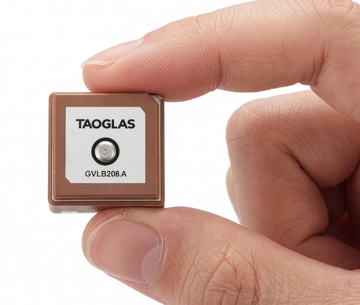
Taoglas has launched the GVLB208 series, an active and passive dual-band GNSS L1/L5 stacked patch antenna — the first in a new family of ultra-compact antennas.
Combining a tiny package with concurrent L1/L5 support and stable right-hand circular polarization (RHCP), the antennas deliver reliable centimeter-level positioning in a compact 20 x 20 x 8 mm footprint.
The GVLB208 series is designed for applications that require high-precision positioning in a compact form factor. Its size, dual-band support and circular polarization make it suitable for designers looking to improve positioning performance without increasing device footprint.
The new antennas address this challenge with a single-feed stacked patch design that supports concurrent L1 and L5 GNSS bands. By leveraging dual-band operation, they significantly reduce the impact of multipath interference, enabling more reliable positioning and improved accuracy in complex RF environments.
The series delivers dual-band L1/L5 performance typically associated with larger GNSS patch antennas. The antenna achieves peak gain of up to 1.5 dBi, approximately 50% efficiency across both bands, and an axial ratio of around 4 dB, supporting stable RHCP signal reception and consistent positioning performance.
Optimized for major global GNSS constellations, including GPS, Galileo, GLONASS and BeiDou, the GVLB208 series supports reliable operation across varied RF environments.
The passive GVLB208 A single-feed architecture enables dual-band L1/L5 performance without the complexity of multi-feed designs, while its pin-mount configuration simplifies RF layout and integration. It can be easily implemented on standard PCB designs, with optimal performance achieved on a typical 70 x 70 mm ground plane.
The active AGVLB208.A, including active electronics and filters, is supplied with 1.13 micro-coax cable and an I-PEX MHF I connector for easy integration with the latest multiband GNSS modules.
The GVLB208 series is suitable for autonomous delivery robots requiring seamless sidewalk navigation and precise drop-offs, where every centimeter counts. It also supports applications including unmanned aerial vehicles (UAVs), telematics systems, fleet and asset tracking, precision agriculture, and industrial IoT deployments.
Taoglas plans to expand the GVLB208 family later this year with an active SMD variant with integrated active electronic components, designed for automated high-volume manufacturing.
Taoglas will showcase its latest antenna technologies at the 2026 European Conference on Antennas and Propagation (EuCAP) in Dublin, Ireland, taking place April 19-24, in the Dublin convention center. Taoglas will display at Stand 52.
At this year’s exhibition and conference, Taoglas will underline the increasing complexity of antenna integration in electronic systems, where performance depends on interactions between the antenna, PCB, enclosure and multi‑radio environment.
The company also will host a “GNSS Evolution Masterclass: Bridging Theory and Field Performance” on April 21, 15:50-17:30. The session will cover the evolution from single‑band to multi‑band GNSS and provide practical guidance on antenna characteristics, performance metrics, correction services and evaluation methods for real‑world positioning performance.
At its booth, Taoglas will highlight its AI-driven Antenna Product Recommendation Engine, designed to help users identify antenna options based on needs. It complements Taoglas’ existing design and configuration tools, including the Antenna Integrator for PCB placement, which adds new features and antenna models frequently, enabling a seamless path from initial selection through to integration.
In the technical conference programme, Taoglas will also present new antenna design work, including a poster on innovations in tri‑band Wi‑Fi antenna integration and a paper on compact antennas for LPWA and IoT devices.
“EuCAP is a unique opportunity to connect cutting‑edge research with real‑world engineering challenges,” said Dermot O’Shea, co‑founder and CEO of Taoglas. “With Taoglas’ roots in Ireland, it is especially rewarding to highlight local RF and antenna expertise while engaging with the global engineering community.”
Taoglas is supporting EuCAP 2026 as a gold sponsor. Visitors can meet the Taoglas team at the event or visit www.taoglas.com for more information.
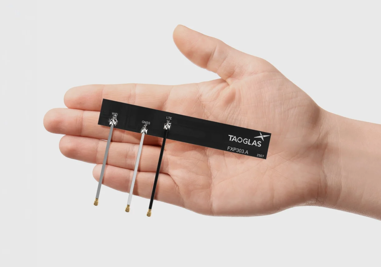
Taoglas is now offering the FXP30x and PC30x series of high-performance embedded combination antennas, a new family of compact antennas designed to support GNSS, cellular and Wi-Fi connectivity for space-constrained electronic devices. Both series enable engineers to integrate multiple wireless technologies within a single antenna, reducing device component count while simplifying device design, speeding up assembly times and accelerating time to market.
The new portfolio includes six antenna models across two form factors: the FXP30x flexible PCB antenna series and the PC30x rigid FR4 PCB antenna series. Both families support cellular frequencies from 600 MHz to 8000 MHz, enabling global connectivity across multiple wireless standards.
The FXP30x series is built on Taoglas’ flexible polymer antenna technology, combining high radiation efficiency, ground-plane independence and ultra-thin construction suitable for installation inside compact device enclosures. The antennas feature peel-and-stick adhesive backing for secure mounting on non-metal surfaces such as plastic housings or glass, while flexible PCB construction allows installation in tight internal spaces where rigid antennas may not fit.
The PC30x series provides the same connectivity options in a rigid PCB antenna built on an FR4 substrate, offering a mechanically stable alternative for applications where the antenna can be mounted directly inside the device enclosure either by adhesive backing or plastic screws.
Each antenna is supplied with a pre-assembled cable and I-PEX MHF I connector. The cables are supplied in different colors to ensure accurate connections for variants that require longer cables, enabling straightforward integration with wireless modules.
Taoglas has launched its AI-driven Antenna Product Recommendation Engine, a platform that helps engineers and organizations select the company’s antennas and RF components.
Available worldwide, the tool provides both seasoned RF engineers and non-technical decision-makers with intelligent guidance to make informed choices.
Early-stage antenna decisions can disproportionately impact system performance, cost and time to market. Yet engineers often rely on datasheets, parametric searches, or manual cross comparison, a process that can consume hours or days amid the growing complexity of modern RF systems.
The new recommendation platform embeds two decades of Taoglas expertise into a digital tool, applying AI trained on real-world design knowledge to scan, filter and refine suitable products in minutes, drawing on insights from tens of thousands of projects worldwide.
The tool is the newest addition to the AntennaXpert ecosystem, complementing Taoglas’ Antenna Builder and Cable Builder for configuration, as well as the Antenna Integrator for PCB placement. Together, they enable a seamless path from initial selection to integration, Taoglas said.
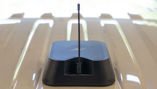
Taoglas has expanded of its Comet Series with the MA58x family of compact, discrete, screw- or through-hole mount puck antennas.
Metal structures or flat surfaces, such as cabinets, can affect antenna performance and change the electrical groundplane. The Comet MA58x series is specifically engineered to maintain stable, high-efficiency operation in these challenging conditions.
Conventional LTE antennas rely on their RF cable to achieve low-band efficiency, particularly when the cable itself is routed inside a metal enclosure, turning it into an unintended radiator. The MA58x design removes this dependency, enabling efficient radiation and delivering at least 20% better performance than comparable alternatives.
With a footprint of 101 x 101 mm and low profile of 20 mm, the antennas deliver reliable multi-antenna connectivity across GNSS constellations including GPS, GLONASS, Galileo, and BeiDou, as well as 5G/4G MIMO and Wi-Fi 6/7. Advanced RF design enables consistent gain and efficiency across global cellular frequencies from 600 MHz to 6 GHz and Wi-Fi bands up to 7.125 GHz, while also supporting legacy 2.4/5.8 GHz Wi-Fi and Bluetooth for maximum compatibility. These levels of performance are rarely achieved in antennas of this size, and even more so when installed on metallic structures.
The rugged, weather-resistant housing is molded in Acrylonitrile Styrene Acrylate (ASA) for long-term outdoor durability, and the IP67-rated enclosure with a screw/stud mount provides a permanent installation option that ensures secure, reliable operation in vibration-prone and harsh conditions such as fleet vehicles, heavy equipment, and industrial automation.
The new antennas are available in multiple configurations and in either black or white enclosures. Custom cable lengths and connector options are also offered, making integration more flexible for OEMs and system designers. The MA58x series is suited to gateways and routers, public safety systems, point-of-sale terminals, digital signage, smart home automation, robotics and industrial automation. The Comet Series also offers a magnetic mount MA32x variant to address different deployment needs.
Further details on the design principles that deliver these performance gains are available in a Taoglas white paper.
Taoglas has introduced the Patriot series, a compact, multi-function combination roof mount antenna designed for connected vehicle fleets in emergency services, utilities and commercial sectors. The Patriot integrates up to 18 antenna elements within a single low-profile enclosure, aiming to provide robust multi-network connectivity while reducing vehicle roof clutter and simplifying installation processes
The antenna was originally developed for the Ford Interceptor, allowing for a direct replacement of the vehicle’s OEM antenna. This approach maintains the original antenna’s functionality and adds multi-radio connectivity, eliminating the need for additional holes to be drilled in the vehicle roof. The design is intended to streamline and reduce installation time and costs for upfitters, offering public departments potential savings on antenna-related expenses and removing the requirement to fill in roof holes when vehicles are resold.
The Patriot supports 5G and 4G cellular networks across the 600–6000 MHz range, dual-band GNSS (L1 and L1/L5) with a secondary GNSS (L1), Wi-Fi at 2.4 GHz, 5.8 GHz and 7.1 GHz, SDARS at 2.3 GHz, and LMR/TETRA at 380 MHz to 400 MHz and 700 MHz to 900 MHz. This enables the antenna to deliver concurrent broadband, navigation, telemetry and voice services. A dedicated whip element with full P25 VHF/UHF/700-900 MHz support is available in multiple lengths to meet various frequency requirements.
The platform is flexible and scalable, with the patent-pending design allowing for customization to specific application needs. Full 17- and 18-in-1 configurations are currently available, and additional variants with up to 18 integrated elements are planned based on customer requirements. This modular approach enables organizations to match antenna performance and connectivity with operational needs while maintaining a consistent mechanical design.
The Patriot’s housing is rated IK08 and IP69K for impact and water resistance, measuring 205 mm in length by 180 mm in width, with a variable whip height between 60 mm and 164 mm. The enclosure is designed to fit between vehicle roof ribs and uses the existing OEM mounting hole. A custom-engineered foam gasket ensures a secure and interference-free installation on curved vehicle roofs. The aerodynamic design is intended to enhance vehicle aesthetics and reduce wind resistance, and the antenna is available in black, white and other colors to match vehicle exteriors.
Signal performance is engineered for optimal gain, isolation and efficiency across all supported frequency bands. Cable types, lengths and connector options are customizable to suit specific installation requirements.
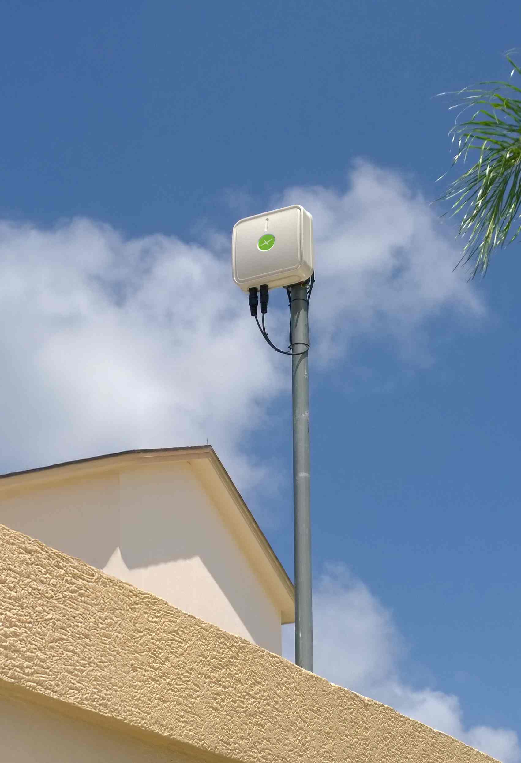
Taoglas has launched its new Thunder Series — a high-performance outdoor antenna enclosure platform engineered to support direct integration and installation of industrial routers within the antenna package. Designed for demanding outdoor environments, the series helps engineers optimize installations, reduce signal loss, and significantly lower deployment costs.
Purpose-built for widely deployed routers from Digi, Ericsson and Semtech, the Thunder Series combines Taoglas’ wideband antenna technology with a rugged enclosure that allows the router to be installed directly inside the housing. This significantly reduces the need for long RF cables – cutting tens of meters per deployment – while minimizing signal loss, installation time, and the material and labor costs typically associated with separate device installations.
Thunder is being deployed in number plate recognition systems, powered directly from streetlight DC infrastructure – reducing cabling requirements and enabling discreet, efficient installation in urban environments.
Operating across a broad 600–6000 MHz frequency range, the Thunder Series supports 5G/4G, Wi-Fi, GNSS and Bluetooth. This wide coverage enables support for low-band cellular, mid-band 5G, and Wi-Fi 6/6E frequencies. The solution provides quality communication by locating the router and the antenna in the same enclosure to minimize cable loss and reduce installation costs while simplifying implementation and deployment. This ensures long-range performance and reliable high- or low-speed data connectivity. The addition of the POE splitter makes powering the router less complicated.
The Thunder Series is available in directional and omnidirectional versions, with IP67-rated ABS enclosures protecting against water ingress, dust and vibration. It is well-suited for harsh outdoor conditions and mission-critical deployments across transportation, mining, agriculture, smart cities and industrial automation. In one such application, Thunder is being deployed in number plate recognition systems, powered directly from streetlight DC infrastructure – reducing cabling requirements and enabling discreet, efficient installation in urban environments.
To support flexible deployment, the Thunder Series can be powered in several ways depending on the router in use. These include dedicated power inputs or Power over Ethernet (PoE), with Taoglas providing detailed guidance to ensure safe, standards-compliant installation.
The Thunder Series is available now via the Taoglas website and through the company’s authorized distribution network.
Read a roundup of recent products in the GNSS and inertial positioning industry from the March 2025 issue of GPS World magazine.
Surveying and Mapping
Photo: Eos Positioning Systems
New Eco-Friendly Carrying Case For Eos Positioning Systems’ receivers
The Skadi Gold, Skadi 300 and Skadi 200 GNSS receivers will now be shipped in a field-rugged carrying case made entirely from recycled materials. The case is designed to meet the demands of professionals who utilize GNSS technology in challenging environments. Its construction incorporates durable, eco-friendly materials that can withstand various field conditions, from remote wilderness areas to urban construction sites.
A key feature is its composition of 100% post-consumer recycled resin, which significantly reduces waste and promotes environmental sustainability, according to the company. It is specifically engineered to be shock-resistant and weatherproof.The case is provided as a standard inclusion with every purchase of the Skadi Gold, Skadi 300 or Skadi 200 GNSS receivers at no additional cost.
Multibeam Sonar Designed for bathymetric surveying
The Gemini 1200id is built on the same robust platform as the Gemini 720is multibeam sonar. The device features a 120° horizontal field of view, operating at both 720 kHz and 1,200 kHz acoustic frequencies.
The Gemini 1200id incorporates advanced noise reduction technology to significantly improve the attenuation of waterborne electrical noise to enhance imaging performance. An integrated speed-of-sound sensor ensures high positional accuracy of displayed targets, while CHIRP processing technology enhances target separation over extended ranges.
Compatibility with Tritech’s Genesis software package allows users to control multiple Tritech products from a single interface to streamline operations. The company has also made software development kits available for Windows and Linux operating systems to integrate into various platforms. The sonar’s design includes a custom-developed analog front-end solution with fully differential receiver channels, making it ideal for longer-range applications.
HiPer XRa is a GNSS receiver for surveying, mapping and construction applications. It can benefit a wide variety of users, including construction professionals, surveyors, geographic information systems (GIS) professionals, archeologists, engineering firms and more. The HiPer XR supports GPS, GLONASS, Galileo, BeiDou, IRNSS, QZSS and SBAS.
The new receiver has advanced Topcon Integrated Leveling Technology (TILT) compensation, featuring a calibration-free and magnetic interference-immune integrated IMU that provides up to 60° of tilt for precision measurements in challenging positions. It has signal integrity protection, anti-jamming and anti-spoofing capabilities. Through the myTopcon NOW! website, users can access online training materials, firmware updates and additional software resources.
Airborne Lidar System Ideal for coastline and river surveying
CoastalMapper is an airborne bathymetric lidar system for coastline and river surveying. The CoastalMapper can survey coastlines and rivers 250% faster than previous sensor models, according to Leica Geosystems.
It is suitable for various mapping applications, from assessing infrastructure resilience to monitoring river floods and conducting environmental investigations.
It features a high-performance bathymetric lidar module, a Leica TerrainMapper-3 topographic lidar and an imaging sensor, integrated into a compact and lightweight sensor head. This allows the CoastalMapper to capture up to 1 million bathymetric data points and 2 million topographic data points per second while providing high-resolution imagery with a 5-cm ground sampling distance at typical flying heights.
It integrates with Leica Geosystems’ airborne mapping workflows and offers cluster processing capabilities, allowing users to analyze large datasets and reduce the time from data collection to final deliverables. These outputs can include classified point clouds, digital terrain and surface models, and various imaging products.
Surveying Kit Streamlines base station and checkpoint setup
WingtraGROUND, a comprehensive survey kit, streamlines base station and checkpoint setup for on-site post-processing kinematic surveys with the WingtraONE Gen II, a vertical takeoff and landing UAV. The kit combines receivers, checkpoints and tools into a single, portable workflow.
The system integrates hardware components with a Wingtra tablet interface, which can help surveyors confirm correct receiver placement and avoid common errors associated with improper base station setup and inaccurate coordinates.
Wingtra receivers, equipped with Emlid Reach RS3 technology, provide accuracy within 2 cm, meeting high standards for aerial data validation. These receivers can also function independently for terrestrial surveys in real-time kinematic mode, including point collection and stakeout for various applications.
Galileo HAS-Enabled Receiver Offers positioning capabilities with 20 cm accuracy
The Geode GNS3H supports Galileo High Accuracy Service (HAS). It offers positioning capabilities with 20 cm accuracy worldwide without requiring additional infrastructure or subscriptions.
It is built to withstand tough conditions, making it ideal for demanding fieldwork. The device offers various accessories, including the Geode Grip, which combines the Geode with a data collection device of choice into a single handheld solution. A backpack strap kit and survey pole are also available to enhance mobility and flexibility in the field. The GNS3H can be used for surveying, agriculture, construction, forestry, mining and archaeology.
Expanded Mapping Portfolio 3D mapping technologies and more
Topcon Positioning Systems has become an authorized distributor of Pix4D’s photogrammetry software portfolio.
The partnership aims to enhance reality capture solutions across various industries, including surveying, mapping, utilities infrastructure, public safety, forensics, and architecture, engineering and construction.
The agreement streamlines the procurement process for end users by allowing them to access Pix4D’s advanced photogrammetry software solutions through Topcon’s global distribution network.
The GNSS real-time kinematic (RTK) 5 Click — a compact add-on board for high-precision positioning and navigation demands — features the UM980, an all-constellation multifrequency RTK positioning module from Unicore, with the advanced NebulasIV SoC for enhanced performance.
It supports Swift Navigation’s Skylark precise positioning service, multiple GNSS constellations and RTK positioning for centimeter-level accuracy. The board also features JamShield technology for robust performance in challenging environments, USB connectivity for easy configuration and visual status indicators for module status and GNSS signal reception.
It can be used for a variety of applications, including surveying and mapping, precision agriculture, UAVs, autonomous robots and autonomous driving.
Multi-Band GNSS Antenna Can operate in urban environments
Levity Series’ AHP24510 (L1/L2/L-Band) and AHP54510 (L1/L5/L-Band) directional patch antennas are designed to receive signals from GPS, Galileo, GLONASS and BeiDou satellite constellations.
These antennas offer faster and more accurate signal acquisition and lock, specifically in urban environments. The L-Band capability allows compatibility with high-precision GNSS correction services. The multi-band antennas offer integral redundancy to minimize satellite security blind spots and reduce energy consumption due to faster acquisition, requiring less system uptime to save power.
The Levity Series active antennas feature a 45 mm x 45 mm x 10 mm wide-band, dual-stacked patch design with a dual-feed, low noise amplifier, providing 28 dB to 29 dB gain and filtering. They operate with a maximum antenna VSWR of 1-to-1 from 1,207 MHz to 1,603 MHz, and the passive antenna efficiency ranges from 39.93% to 68.51% in the L1 band. These antennas use right-hand circular polarization to mitigate multi-path interference.
The Levity Series includes other multi-band products for high-precision applications, such as the HP24510A and HP54510A stacked-patch passive components, and the TFM.120A surface-mount front-end module, which covers the full multi-band GNSS spectrum including L-band. These antennas are suitable for various applications, including wearables, transportation, robotics, precision agriculture and autonomous vehicles.
The M9PLUS-HCT-A-SMA is an active multi-frequency GNSS antenna designed for high-accuracy applications. It supports L1/L2/L5 GPS, Galileo, Beidou and GLONASS bands, as well as L-band correction services. The antenna utilizes Maxtena’s proprietary Helicore technology, which offers advanced pattern control, polarization purity and efficiency in a compact form factor.
It integrates a pre-filter specifically engineered to mitigate LTE interference. This is crucial for maintaining signal integrity in environments with dense mobile communication networks, where LTE signals can overlap with GNSS frequencies. The pre-filter can effectively block out-of-band LTE signals, reducing intermodulation risks and ensuring clear GNSS signal reception.
The M9PLUS-HCT-A-SMA is built with rugged, IP67 automotive-grade components and includes an integrated SMA connector. It also features an O-ring for enhanced environmental sealing. Weighing only 24 grams, the antenna is ground plane-independent, making it versatile for various installations. It is particularly well-suited for GIS and RTK applications where high accuracy and reliability are crucial.
The MostaTech G321M is a three-axis fiber optic gyroscope (FOG) that offers high-precision navigation and orientation measurement capabilities. This advanced sensor features a data rate of 8 kHz.
Key features of the G321M include an input range of 400° per second, a bias RMS of 1° per hour and an angular random walk of 0.025 °/√h. Additionally, it has a power consumption of 2 W and an initialization time of 1 second. The G321M is designed with a compact form factor, making it suitable for various applications where size and weight are critical factors.
It is ideal for UAVs, robotics, borehole surveys, image stabilization, gimbal stabilization and underwater vehicles.
High-Precision Lidar Designed for precision applications
The TV1 Lite and the TV1 UAV systems are designed for various precision applications, such as mapping and data collection.
The TV1 Lite features TrueNav technology, a Hesai 32-channel laser scanner and a FLIR 5MP global shutter camera with a 90° field of view. It also includes one year of TV1 Lite Annual Processing with support and maintenance.
TV1 offers customization options, allowing users to choose from 26 MP, 45 MP or 61 MP cameras and various Trajectory Correction Service options.
Flight Control System With autopilot functionality
The Prism Supervisor software combines UAV autopilot flight control systems with AI-based observations processed in real time, aiming to enhance UAV operations.
The system provides a programming framework and software development kit for users to create custom mission scenarios. During flight, Prism Supervisor can adapt its autopilot functionality in real time, generating mission segments and flight plans as needed.
The software features a user-friendly graphic interface for mission planning, real-time visualization and execution. It supports Windows, Linux, macOS, iOS and Android.
Remote ID Receiver Enhances airspace awareness and UAV safety
RIDER is designed to enhance situational awareness by providing real-time detection of UAV activity in sensitive areas. It also seeks to provide a clear visibility of surrounding UAV operations to help avoid potential collisions and ensure safer flight experiences.
The device features a built-in industrial chip SIM that provides global coverage through LTE-M and NB-IoT, ensuring connectivity in various environments.
It operates effectively within a temperature range of -20 °C to +60 °C and is rated IP54 for dust and water resistance. The device complies with ASTM F3411-22A and ASD-STAN EN 4709-002 standards, making it suitable for regulatory environments.
The RIDER can detect signals from up to 5 km with its default antennas and up to 10 km when using an optional high-performance antenna. It is equipped with an internal cellular and Bluetooth antenna, along with an integrated GNSS antenna that provides precise positioning and timestamping capabilities. It supports multiple GNSS frequencies and utilizes Bluetooth and Wi-Fi technologies for Remote ID communications.
Streamlined BVLOS Operations For a variety of applications
The Sentaero 6 UAV is designed for advanced over-the-horizon operations beyond visual line of sight (OTH-BVLOS). It features built-in AI and machine learning capabilities for real-time data processing. The system can be used for surveying, mapping, inspection, asset monitoring and more.
Engineered to streamline operations, the Sentaero 6 offers more accurate and up-to-date intelligence on assets. Its onboard computer can processes data mid-flight.
Future developments will include swarm operations, enabling one human to control multiple UAVs simultaneously; fully remote operations and higher safety standards, such as a parachute for urban missions, according to Censys Technologies.
SBG Systems has significantly updated its Ellipse series sensors, incorporating the latest World Magnetic Model (WMM) to enhance accuracy and reliability in navigation applications. This upgrade is available for all Ellipse sensors, including first-generation models.
Designed for unmanned systems such as UAVs, UGVs and marine platforms, the Ellipse series comprises compact, high-precision inertial sensors. These devices feature built-in three-axis magnetometers that measure Earth’s magnetic field, crucial for accurate heading and positioning data.
Updated every five years, the WMM is a globally recognized mathematical representation of Earth’s magnetic field. The latest version, released in December 2024, ensures precise heading and positioning corrections to account for ongoing geomagnetic changes.
NDAA-Compliant UAV Now integrated with ArcGIS Flight
Esri now supports the Astro Max UAV in its ArcGIS Flight application. The Astro Max is the first Blue UAS-cleared and NDAA-compliant UAV to integrate with Esri’s platform.
The Astro Max, developed by Esri partner Freefly Systems, adheres to the security and performance standards set by the National Defense Authorization Act and the Defense Innovation Unit’s Blue UAS initiative. This industrial UAV is designed to enhance the capabilities of government and enterprise users utilizing ArcGIS Flight.
Autonomous Swarm Control Controls various autonomous platforms
The Autonomous Multi-Domain Operations Resiliency Platform for Heterogeneous Unmanned Swarms (AMORPHOUS) software features a single-user interface to operate thousands of autonomous assets simultaneously. Designed with an open architecture, this software enables the U.S. and allied militaries to control a mix of uncrewed platforms, payloads and systems.
AMORPHOUS includes an intuitive and distributed command-and-control interface to give operators the flexibility to conduct a wider array of intricate military missions. This collaborative autonomy at scale will provide warfighters with a decisive overmatch capability.
L3Harris is developing prototypes using the AMORPHOUS architecture on contracts for the U.S. Army and the Defense Innovation Unit. AMORPHOUS has demonstrated flexibility and interoperability by controlling multiple, separate assets across multiple vehicle types operating in different domains during government-managed tests.
AMORPHOUS supports decentralized decision-making, which enables individual, uncrewed assets to perform tasks autonomously and make real-time tactical decisions inside the network.
Advanced Counter-UAV Radar Multi-console radar control and display system
Cambridge Pixel has developed a radar control and display system for Weibel Scientific’s XENTA surveillance radar, which is designed for modern air defense and counter-unmanned aerial systems (C-UAS) applications.
The XENTA radar includes 3D target tracking, continuous target illumination and synthetic receiver beamforming. It is available in two configurations: the XENTA-M for short-range air defense and the XENTA-C for C-UAS operations.
The system is designed to work seamlessly with third-party command-and-control systems, enhancing operational efficiency.
Cambridge Pixel’s library of radar processing software allows users to develop a tailored radar controller specific to the XENTA radar’s requirements. Enhancements were made to existing functionalities, such as improved MIL-STD-2525 overlay graphics and support for dual-redundant operator consoles.
The XENTA radar system can detect small UAVs at distances exceeding 7 km and classify them beyond 5 km. This capability makes it suitable for various applications, including airport security, border control, critical infrastructure protection and event security.
The Pelican 2 agricultural spray UAV has an expanded 300-liter payload capacity and can cover up to 5.3 ha/hr.
It incorporates several technological enhancements designed to meet the demands of agriculture applications. The aircraft features an upgraded four-motor electric propulsion system, a wider 18-m spray swath and advanced lidar and radar systems for fully autonomous day-and-night spraying. These improvements aim to increase efficiency and precision in aerial application while reducing operational costs for farmers.
The Pelican 2’s airframe and structural components are constructed from carbon fiber composites, corrosion-resistant metallic components and 3D-printed assemblies.
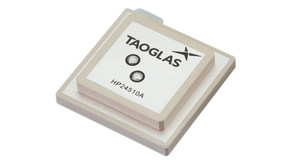
Taoglas has released a new family of active, multi-band GNSS antennas. Levity Series’ AHP24510 (L1/L2/L-Band) and AHP54510 (L1/L5/L-Band) directional patch antennas are designed for GPS, Galileo, GLONASS and BeiDou satellite constellations.
These antennas offer improved performance through triangulation across multiple satellites, offering faster and more accurate signal acquisition and lock, specifically in urban environments. The L-Band capability allows compatibility with high-precision GNSS correction services, potentially achieving positioning accuracy better than 200 cm.
The multi-band antennas seek to offer integral redundancy to minimize satellite security blind spots and reduce energy consumption due to faster acquisition requiring less system uptime to save power.
The Levity Series active antennas feature a 45 mm x 45 mm x 10 mm wide-band, dual-stacked patch design with a dual-feed, low noise amplifier, providing 28 dB to 29 dB gain and filtering. They operate with a maximum antenna VSWR of 1-to-1 from 1,207 MHz to 1,603 MHz, and the passive antenna efficiency ranges from 39.93% to 68.51% in the L1 band. These antennas use right-hand circular polarization to mitigate multi-path interference.
The Levity Series includes other multi-band products for high-precision applications, such as the HP24510A and HP54510A stacked-patch passive components, and the TFM.120A surface-mount front-end module, which covers the full multi-band GNSS spectrum including L-Band.
These antennas are suitable for various applications, including wearables, transportation, robotics, precision agriculture and autonomous vehicles.
A roundup of recent products in the GNSS and inertial positioning industry from the August 2024 issue of GPS World magazine.
SURVEYING & MAPPING
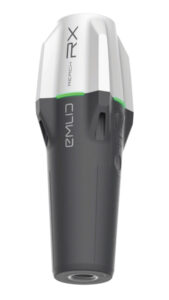
Upgraded RTK Rover Features MFi certification
The Reach RX Network real-time kinematics (RTK) rover has been upgraded to include new MFi (Made for iPhone/iPad) certification and is fully compatible with ArcGIS, QGIS and other GIS apps for both iOS and Android. Reach RX can be seamlessly integrated into GIS workflows to help industry professionals and teams collect accurate geodata at scale.
The Reach RX offers precise positioning while receiving corrections through NTRIP and tracks GPS/QZSS, Galileo, GLONASS and BeiDou. It gets a fix in less than 5 seconds, delivering centimeter-level accuracy even in challenging conditions.
It can be used for engineering, utility inspection, landscaping and other projects of any scale. According to the company, the rover will soon be compatible with QField, Blue Marble’s Global Mapper, Mergin Maps, Avenza Maps and more.
The Reach RX weighs 250 grams; is IP68-rated, waterproof and dustproof; and withstands temperatures from -20° C to +65° C.Emlid, emlid.com
Photogrammetric Software Upgraded coordinate system functionalities
3Dsurvey 3.0 is an all-in-one photogrammetric software solution designed to unify lidar sensors, cameras on UAVs and various ground control points. Users can transition between orthophotos, point clouds and textured meshes.
Version 3.0 features upgraded coordinate system functionalities to obtain georeferenced spatial data without local transformations.
It includes improved coordinate system support, which handles transformations requiring special grid files and offers accurate GPS-to-local coordinate conversions. Additionally, the platform can automatically fetch missing geoid models.
The revamped coordinate system selection process includes presets for users to find the correct system by entering their country name, with the appropriate settings applied automatically. It has PRJ file support to enhance compatibility with various GIS standards. 3Dsurvey, 3dsurvey.si
RTK Evaluation Kit Includes L1+L2 RTK GNSS
This real-time kinematics (RTK) evaluation kit (EVK) serves as a development platform for fixed or mobile high-precision positioning and navigation needs.
The RTK EVK comes with a range of options for prototyping, including L1+L2 RTK GNSS, with L-Band correction built-in if needed, running on an agile processor.
It features custom open-source software pre-loaded with RTK Everywhere firmware. Users can configure the EVK as an RTK base and push corrections to an NTRIP Caster or use corrections delivered through WiFi or Bluetooth.
The integrated u-blox NEO-D9S offers L-Band reception and access to correction services such as PointPerfect. The u-blox LARA-R6001D provides global cellular connectivity, and Zero-Touch RTK offers users a simple way to receive corrections. Users can register the device and enable PointPerfect — no NTRIP credentials are required. Sparkfun Electronics, sparkfun.com
GNSS Receiver With tilt compensation
The R980 features communication capabilities to support uninterrupted field operations. It can be used for land surveying, transportation infrastructure, construction, energy, oil and gas, utilities and mining projects.
The system features Trimble’s ProPoint GNSS positioning engine and inertial measurement unit (IMU)-based tilt compensation, making it suitable for dense urban environments and under tree canopy, removing the need to level the pole when capturing data points.
It includes a dual-band UHF radio and an integrated worldwide LTE modem for receiving corrections from a local base station or VRS network. It supports the Trimble Internet Base Station Service (IBSS) for streaming RTK corrections using Trimble Access field software and features Trimble IonoGuard technology, which mitigates ionospheric disturbances for RTK GNSS. Trimble Geospatial, geospatial.trimble.com
Nautical Chart Production Generate charts in PDF/TIF from ENC data
CARIS AutoChart, a nautical chart production solution, is tailored to the needs of nautical chart producers. It can automatically generate charts in PDF/TIF from ENC data. Users can seamlessly import data from ENC files to create comprehensive nautical charts in PDF and/or TIF format. CARIS AutoChart can generate chart templates from existing chart portfolios maintained with CARIS paper chart composer or CARIS HPD paper chart editor.
The software is designed to accommodate the unique needs of chart production facilities of all sizes. It can be used by hydrographic offices, port or waterways authorities.Teledyne Geospatial, teledyneimaging.com
Felt 3.0 includes new features and native database integrations to improve the capabilities of geographic information systems (GIS). It provides modern GIS tools for teams to visualize, analyze and present important insights and map data relevant to their operations.
Operators can directly connect Postgres/PostGIS and Snowflake databases for automated live data updates. The API allows users to create and style elements and listen to map updates via webhooks, while providing a Python SDK for professionals to continue to work in their preferred tools. Felt, felt.com
UAV
Gimbaled Camera For UAV missions
The Gimbal 155 is a gimbaled camera designed for the UAV Survey Mission program. The GOS-155 meets UAV requirements for surveillance and rescue missions. Its optimized size, weight and power (SwaP) profile, advanced day and night ISR imaging, and embedded video processor make it ideal for any mid-sized UAV — whether VTOL or winged. With its low weight of 1.8 kg, and 155 mm, UAV platforms can increase endurance without sacrificing optical performance.
The GOS-155 two-axial gimbal is an EO/IR system, comprising a 30x optical zoom HD (1280 x 720) visible camera paired with a fixed focal length uncooled thermal LWIR (1280 x 1024) camera. This allows users to collect intricate visuals across visible and infrared spectrums.
It includes embedded video processing with electronic stabilization and object tracking and can be integrated with external GPS/INS with real-time target location at 20 m across multiple environments, and around 5 m using UAVOS’ Ground Control Station software. UAVOS, uavos.com
Tactical Grade INS Tailored to unmanned systems
The FN 200C combines multiple functions into a single integrated platform. It features a three-in-one strapdown system compromising motion reference unit (MRU), attitude and heading reference system (AHRS) and inertial navigation system (INS) capabilities for precise positioning, velocity and orientation data in both static and dynamic movements.
It is equipped with fiber optic gyroscopes (FOG) and MEMS accelerometers. The FN 200C’s inertial measurement unit (IMU) offers accurate and reliable navigation data even in challenging conditions. The system supports various correction methods such as SBAS, DGPS, RTK, and PPP for real-time navigation and positioning in a wide range of applications.
The FN 200C utilizes NovAtel OEM7, u-blox ZED-F9P or Septentrio mosaic-H GNSS receivers to provide precise positioning information across multiple GNSS constellations. With embedded anti-jamming and spoofing features, the FN 200C offers reliable operation in environments where signal interference may be present.
The FN 200C is ideal for unmanned systems applications, including land-based surveying, aerial mapping, maritime navigation and more, delivering precise and reliable navigation data to meet the most demanding requirements. According to FIBERPRO, the system’s advanced technology, robust design and comprehensive feature set ensure that it will revolutionize navigation and operation in today’s dynamic and challenging environments. FIBERPRO, fiberpro.com
Upgraded UAV With a modifiable flight controller
The RDSX Pelican extended-range hybrid vertical take-off and landing (VTOL) delivery UAV is now offered with an easily modifiable flight controller, designed for users to more readily integrate customized flight systems and companion software.
The RDSX Pelican combines the reliability and flight stability of a multirotor craft with the extended range of a fixed-wing airframe. Its customizable payload bay can be factory-integrated with the A2Z Drone Delivery RDS2 commercial delivery winch to support a variety of logistics operations.
Engineered to operate within the FAA’s 55-pound max takeoff weight for Part 107 compliance, the Pelican is rated to carry payloads up to 5 kg on operations up to 40 km roundtrip. The flexibility of the Pelican’s cargo bay makes it ideal for logistics missions or deployment with payloads customized for aerial mapping, UAV inspection, forestry services, search and rescue operations, water sample collection, offshore deliveries, mining and more.
With the RDSX Pelican now operating on the Cube flight controller (CUAV X7+), users can integrate their preferred systems — including ground control software, radio beacons and other companion software systems. A2Z Drone Delivery, a2zdronedelivery.com
GNSS Positioning Modules Compatible with UAVs and robotics
The Linnet ZED-F9P is built around u-blox’s ZED-F9P RTK module. It offers multiband signal reception including GPS L1 and L2 for precise positioning, even in areas with low satellite coverage. In addition to USB-C connectivity, it features UART, SPI and I2C interfaces for easy integration into a variety of UAV and robotics platforms.
Linnet Mosaic X5 RTK-GNSS module is based on Septentrio’s mosaic-X5 module, with multifrequency signal tracking including GPS L5. The module features an onboard CPU that runs a full internal web-based user interface for configuration and monitoring, as well as integrated NTRIP corrections. Other capabilities include built-in anti-jamming and anti-spoofing protection and a spectrum analyzer. Systork, systork.io
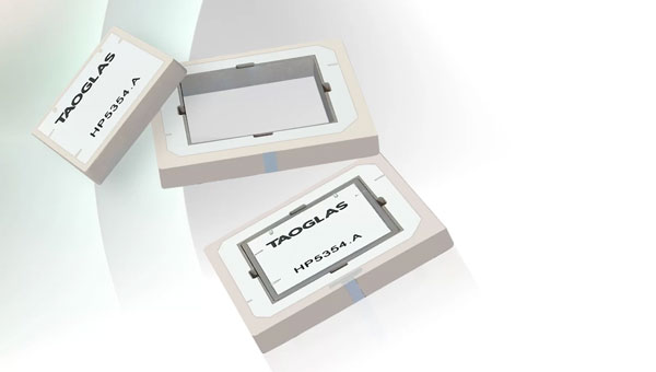
Inception is a new GNSS L1/L5 ultra-low-profile “patch-in-a-patch” antenna. The HP5354.A offers dual-band stacked patch performance in a single 35 mm x 35 mm x 4 mm form factor. This design integrates the second antenna within the first, eliminating the need for stacking parts and reducing the antenna height by 50%.
The HP5354.A antenna features a passive, dual-feed surface mount design (SMD) to decrease weight and conserve horizontal space. This makes it suitable for GNSS applications requiring high precision and limited space. The antenna improves positioning accuracy from 3 m to 1.5 m while maintaining dual-band L1/L5 performance.
With a passive peak gain of 2.61 dBi, the HP5354.A can be used for GPS L1/L5, BeiDou B1, Galileo E1, and GLONASS G1 operations. Its dual-feed design maintains circular polarization gain even when the antenna is de-tuned or requires in-situ tuning.
It is ideal for applications such as asset tracking, smart agriculture, industrial tracking, commercial UAVs and autonomous vehicles. The HP5354.A uses Taoglas’ custom electro-ceramics formula, ensuring high-quality performance and seamless integration into devices requiring high-precision GNSS.
The Taoglas HC125A hybrid coupler can combine the dual feeds for the L1 patch, offering high RHCP gain and optimal axial ratio for upper constellations including GPS L1, BeiDou B1, Galileo E1 and GLONASS G1. The Taoglas TFM.100B L1/L5 front-end module can be incorporated into the device PCB, aiming to save valuable real estate and up to two years of complex design work, according to the company. Taoglas, taoglas.com
Waterproof GNSS Antenna Built-in LNA
The external antenna features an adhesive mount and sealed IP67-rated waterproof protection. It is an active GPS/GNSS antenna that includes a built-in low noise amplifier (LNA) for enhanced performance, making it ideal for applications where the receiver is close to the antenna and in environments where signal strength is strong, such as open areas with a clear line of sight.
This type of antenna can amplify weak signals received from satellites by improving signal quality and reducing noise. It requires an external power source to operate the built-in LNA and is less sensitive to signal loss due to longer cable lengths. It is connected to an SMA connector at the end of a 3 m pigtail. The antennas can be used in navigation, location-based services and fleet management applications. Amphenol RF, amphenolrf.com
DEFENSE
AI and Quantum-Powered Navigation System When GPS signals are compromised
AQNav is designed for navigation across air, land and sea when GPS signals are jammed or unavailable.
AQNav is a geomagnetic navigation system that uses proprietary artificial intelligence (AI) algorithms, powerful quantum sensors and the Earth’s crustal magnetic field. The system seeks to provide an un-jammable, all-weather, terrain-agnostic, real-time navigation solution in situations where GPS signals are unavailable, denied or spoofed.
The system uses extremely sensitive quantum magnetometers to acquire data from Earth’s crustal magnetic field, which exhibits geographically unique patterns. It uses AI algorithms to compare this data against known magnetic maps, allowing the system to quickly and accurately find its position.
It is available globally, does not rely on visual ground features or satellite transmissions to function and is not affected by weather conditions. AQNav can be integrated into a wide variety of platforms. Its passive technology emits no electronic signals, which reduces the aircraft’s detectability. SandboxAQ, sandboxaq.com
PNT Solution Operates with or without GNSS signals
TRNAV is a terrestrial navigation solution designed to operate with or without GNSS signals.
It establishes a mesh network of ground stations capable of operating independently from GNSS by using precise pre-established locations or connecting to GNSS when available. TRNAV’s synchronized timing system ensures a minimal drift of 10 ns during a week without GNSS.
The system features a re-synchronization capability that allows the entire network to be updated instantly when just one station reconnects to a GNSS satellite, maintaining high precision across all platforms. Users can integrate mobile stations to enhance network flexibility and range, with the potential to cover distances up to 250 km.
TRNAV also offers a high-bandwidth communication channel for communication capabilities within the established network. The system employs AES-256 encryption and advanced waveform technologies, including DSSS/FHSS for robust and secure operations in challenging environments. TUALCOM, tualcom.com
Software-Defined Radio Designed for mission-critical systems
Calamine is a four-channel wide tuning range software-defined radio (SDR) that can be integrated into mission-critical systems for the defense, GNSS, communications and test and measurement markets.
The SDR offers a tuning range from near DC to 40 GHz with four independent receiver radio chains, each offering 300 MSPS sampling bandwidth. It is tailored to government, defense and intelligence communities and civil users with direct applications for radar systems, signal intelligence, spectrum monitoring and satellite communications systems. Per Vices, pervices.com
C-UAS Solution For electronic warfare
The Skyjacker is a multi-domain electronic warfare counter unmanned aerial system (C-UAS), suitable against swarms and high-speed threats. It is designed as a response to threats posed by UAVs in the battlespace and at sensitive installations.
Skyjacker alters the trajectory of a UAS by simulating the GNSS signals that guide it toward its target.
Skyjacker is particularly well suited to countering saturation attacks, such as swarming UAVs. The system also can defeat isolated drones piloted remotely by an operator and deliver effects at ranges from 1 km to 10 km (6 mi).
It can be integrated with an array of sensors, such as optronic sights, radars, radiofrequency detectors, lasers, communication jammers and other effectors. Skyjacker can be deployed as a mobile version or interconnected with existing surveillance and fire control systems on land vehicles or naval vessels. Safran Electronics & Defense, safran-group.com
Taoglas has unveiled Inception, a new GNSS L1/L5 ultra-low-profile “patch-in-a-patch” antenna. The HP5354.A offers dual-band stacked patch performance in a single 35 x 35 x 4mm form factor. This design integrates the second antenna within the first, eliminating the need for stacking parts and reducing the antenna height by 50%.
The HP5354.A antenna features a passive, dual-feed surface mount design (SMD) designed to decrease weight and conserve horizontal space. This makes it suitable for GNSS applications requiring high precision and limited space. The antenna improves positioning accuracy from 3 m to 1.5 m while maintaining dual-band L1/L5 performance.
With a passive peak gain of 2.61 dBi, the HP5354.A can be used for GPS L1/L5, BeiDou B1, Galileo E1, and GLONASS G1 operations. Its dual-feed design maintains circular polarization gain even when the antenna is de-tuned or requires in-situ tuning.
It is ideal for applications such as asset tracking, smart agriculture, industrial tracking, commercial UAVs and autonomous vehicles. The HP5354.A uses Taoglas’ custom electro-ceramics formula, ensuring high-quality performance and seamless integration into devices requiring high-precision GNSS.
Emerging GNSS bands such as L2, L5, L6, and L-band offer pathways to cleaner signals, improved gain and centimeter-level accuracy. This trend is crucial for global GNSS technologies, including GPS, GLONASS, Galileo, BeiDou, QZSS, IRNSS, and SBAS.
With an ultra-low profile SMD, the antenna offers stack patch L1/L5 performance within a single-patch solution. It also maintains circular polarization gain with a dual-feed design.
The Taoglas HC125A hybrid coupler can combine the dual feeds for the L1 patch, offering high RHCP gain and optimal axial ratio for upper constellations including GPS L1, BeiDou B1, Galileo E1 and GLONASS G1. The Taoglas TFM.100B L1/L5 front-end module can be incorporated into the device PCB, aiming to save valuable real estate and up to two years of complex design work, according to the company.
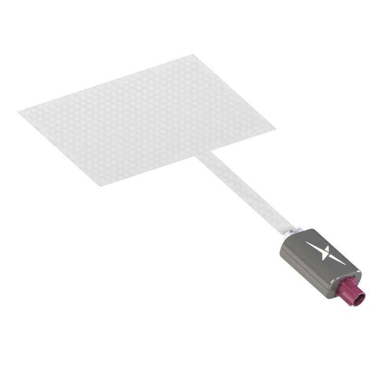
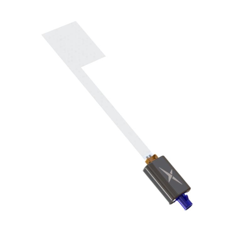
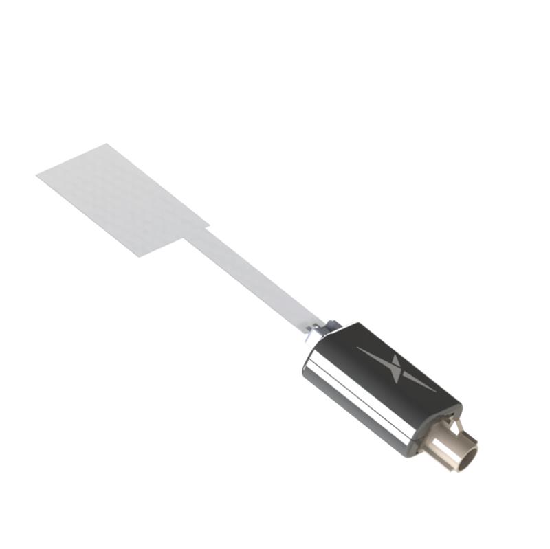
Taoglas has released three near-invisible antennas supporting cellular, Wi-Fi and GNSS technologies, the TFX62.A, TFX257.A and TFX125.A . With “peel and stick” mounting to any nonmetal surface, the TFX series antennas offer an alternative to standard opaque antennas.
The TFX62.A, TFX257.A and TFX125.A come with an adhesive and have an enclosed carrier terminated with a FAKRA connector for easy installation. The series leverages a sub-millimeter thick hybrid transparent conductive film that offers designers an invisible antenna solution.
The TFX series antennas are suitable for mobility, public infrastructure, medical devices, transportation and emerging IoT applications. Use cases for the antennas include electric vehicle chargers and parking meters, smart buildings and transportation vehicles.


 Upgraded RTK Rover
 3Dsurvey 3.0 is an all-in-one photogrammetric software solution designed to unify lidar sensors, cameras on UAVs and various ground control points. Users can transition between orthophotos, point clouds and textured meshes.
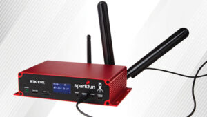 RTK Evaluation Kit
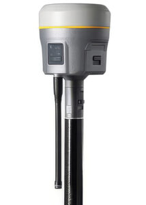 GNSS Receiver
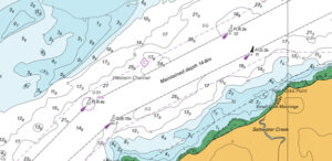 CARIS AutoChart, a nautical chart production solution, is tailored to the needs of nautical chart producers. It can automatically generate charts in PDF/TIF from ENC data. Users can seamlessly import data from ENC files to create comprehensive nautical charts in PDF and/or TIF format. CARIS AutoChart can generate chart templates from existing chart portfolios maintained with CARIS paper chart composer or CARIS HPD paper chart editor.
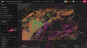 Felt 3.0 includes new features and native database integrations to improve the capabilities of geographic information systems (GIS). It provides modern GIS tools for teams to visualize, analyze and present important insights and map data relevant to their operations.
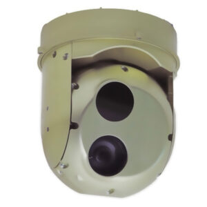 Gimbaled Camera
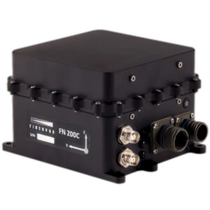 The FN 200C combines multiple functions into a single integrated platform. It features a three-in-one strapdown system compromising motion reference unit (MRU), attitude and heading reference system (AHRS) and inertial navigation system (INS) capabilities for precise positioning, velocity and orientation data in both static and dynamic movements.
 The RDSX Pelican extended-range hybrid vertical take-off and landing (VTOL) delivery UAV is now offered with an easily modifiable flight controller, designed for users to more readily integrate customized flight systems and companion software.
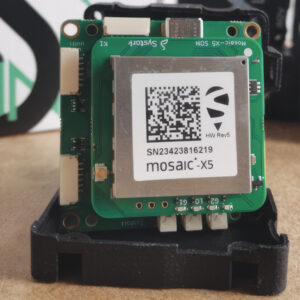 GNSS Positioning Modules
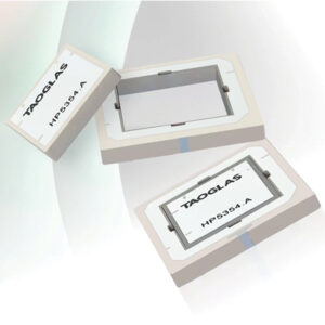 Inception is a new GNSS L1/L5 ultra-low-profile “patch-in-a-patch” antenna. The HP5354.A offers dual-band stacked patch performance in a single 35 mm x 35 mm x 4 mm form factor. This design integrates the second antenna within the first, eliminating the need for stacking parts and reducing the antenna height by 50%.
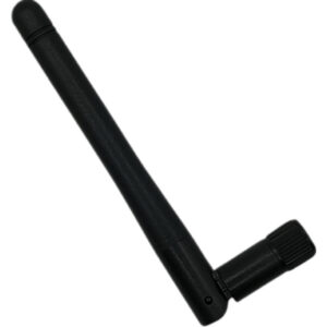 Waterproof GNSS Antenna
 AQNav is designed for navigation across air, land and sea when GPS signals are jammed or unavailable.
 TRNAV is a terrestrial navigation solution designed to operate with or without GNSS signals.
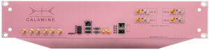 Calamine is a four-channel wide tuning range software-defined radio (SDR) that can be integrated into mission-critical systems for the defense, GNSS, communications and test and measurement markets.
 C-UAS Solution