Hitachi Zosen manages a network of 1,300 reference stations operated by the Geospatial Information Authority of Japan. Nippon GPS Data Service, a subsidiary of Hitachi Zosen, will provide Hexagon with GNSS data from this network.
With access to this data, Hexagon will provide the TerraStar-X Enterprise GNSS correction service, which is suitable for automotive applications. The service is now available for testing in the Tokyo area and will be expanded across Japan.
Hexagon has operational testbeds for TerraStar-X Enterprise in several locations in North America, Europe and China that provide reliable, lane-level accuracy in under a minute. With the addition of a testbed in Japan, vehicle manufacturers and technology providers can use the same design for all their correction service requirements.
By utilizing data created from GSI network observations, Hexagon’s TerraStar-X Enterprise will ensure fast convergence to lane-level accuracy and is available to support large-scale programs with functional safety requirements in Japan.
TerraStar X corrections technology enables lane-level accuracy with under one-minute convergence for consumer and automotive-grade GNSS receivers
Hexagon’s Autonomy & Positioning division has partnered with Chinese positioning company Dayou to bring TerraStar X technology to the Chinese market. TerraStar X provides fast precise point positioning (PPP) corrections for autonomous vehicles and has mass-market use such as in smartphones.
The partnership enables Hexagon and Dayou to provide consistent positioning solutions globally, including North America, Europe and China, so original equipment manufacturers (OEMs) can deploy the same design worldwide.
The GNSS corrections generated from TerraStar X technology enable lane-level accuracy with convergence in under a minute for consumer and automotive-grade GNSS receivers, supporting advanced driver-assistance systems (ADAS), autonomous applications, safety-critical applications, mobile-phone applications and more.
TerraStar X technology delivers corrections using industry-standard formats compatible with mobile networks and enabling efficient delivery of corrections to millions of end-user devices. Through the partnership with Dayou, OEMs can now deploy the same high-accuracy solution across China as in North America and Europe, while having access to local sales, support and technical resources.
“This partnership provides a way for global companies to leverage TerraStar X technology to bring consistent lane-level positioning around the globe,” said Sara Masterson, director of positioning services at Hexagon’s Autonomy & Positioning division. “With its hardware-agnostic design, industry-standard format and delivery of corrections, this technology opens up the possibility of precise positioning for a multitude of new mass-market applications for customers to use one software positioning solution on all platforms worldwide.”
“Dayou is excited to be working with Hexagon in China to bring this next level of positioning technology to market,” said Han Jianxin, chief executive officer at Dayou. “High accuracy positioning used to be limited to expensive equipment and niche markets like survey and mapping. With TerraStar X technology, everyone can have the benefit of more accurate positioning, opening up new applications ranging from autonomous driving and freight to regular smartphone users moving from point A to B.”
Test Regions Expand to China
Using Dayou’s local infrastructure to calculate ionosphere corrections, TerraStar X technology ensures that fast convergence to lane-level and sub-meter accuracy is available when needed.
Engineering development test areas are available around the world to support large-scale programs with functional safety requirements. With these test regions now expanded to China, the partnership with Dayou marks a significant milestone to bring Hexagon’s TerraStar X technology to a global scale.
China Dayou PI is a Chinese company invested in by China Intelligent and Connected Vehicles (Beijing) Research Institute Co. Ltd. for high-precision positioning service and solutions based on GNSS, INS and HD map technology.
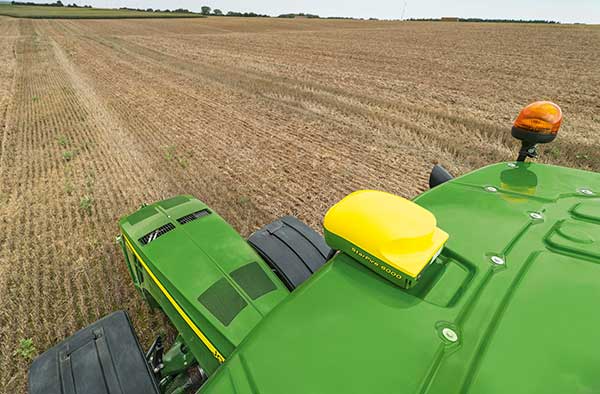
The John Deere StarFire 6000 RTK receiver operating in the field. (Photo: John Deere)
Precision agriculture — the practice of optimizing inputs of seed, water, and fertilizers while maximizing yields by mapping variations in soil characteristics and guiding machinery accordingly — began in the United States in the early 1980s and has been growing steadily. Key components include soil mapping based on sampling and remote sensing, proximal sensing of soils and crops, variable rate irrigation and variable rate spraying of fertilizers and herbicides, and automatic tractor navigation.
“GNSS-based guidance is probably the most highly adopted precision ag technology, followed by variable rate and section control,” said John Fulton, associate professor at The Ohio State University. “I suspect that somewhere around 40% of those GNSS receivers use RTK-level corrections — which provide sub-inch accuracy — and that number is increasing.”
Need for sub-inch accuracy
Water runs downhill, of course, which makes vertical accuracy critical for hydrology. “AgLeader builds a plow to put tile in soil to drain water,” said Bill Cran, AgLeader Technology’s GNSS product specialist. “It might only be 4 inches round; so, if we are off by 2 or 3 inches vertically, that affects where water can run.” To get the best vertical accuracy possible, he recommends farmers install a base station in the field where they are operating.
Sub-inch accuracy also enables farmers to determine where to plant each seed, rather than monitoring planters at the row level. “That may not be a requirement today, but it is certainly coming,” Cran said.
Market demand for RTK in agriculture is increasing, an important factor for drone guidance or machine control, said Gustavo Lopez, market access manager at Septentrio. “The robots are very close to the crops. When small robots are working in a corn field, the corn plants are causing multipath or shadowing GNSS signals,” Lopez said. “You need either a good RTK or GNSS-INS, because if you lose satellite lock you can still coast for a while with an IMU.”
Services and options
AgLeader’s displays have a built-in networked transport of RTCM via internet protocol (NTRIP) client that enables it to connect to NTRIP networks and CORS networks, as well as other free and subscription-based networks. “That allows us to get RTK from the internet for customers that want to go that route,” Cran said. Alternatively, the company offers NovAtel GPS receivers, including Satel- or Freewave-based RTK options with 400 MHz and 900 MHz radio options that can communicate with a similar base station. This spring, it will begin to offer NovAtel’s TerraStar-X service. “We are calling that ‘RTK from the sky,’” Cran said. “The expectation is sub-inch accuracy, with a convergence time of less than one minute. Many of our customers and dealers are very excited about that option.”
Septentrio’s GNSS modules for agriculture are used mostly in mapping drones, Lopez said. The modules mitigate interference and spoofing. “We have also been quite successful in robotics for agriculture,” Lopez said. Septentrio is working closely with the French agriculture robotics company Naïo Technologies, which integrates its robots with Septentrio’s smart antenna GNSS products, providing a full RTK solution as well as autonomy.
For areas without RTK networks, some farmers buy and install Septentrio base stations that provide corrections to their robots or UAVs. Septentrio provides agricultural mapping software for post-processing data gathered without RTK. Also on offer are L-band receivers — while not as accurate as a local RTK network and possibly with higher convergence time, the relative accuracy of L-band corrections is more than good enough for many ag robots, Lopez explained.
On the baseline
The vegetable weeding robot Dino — shown here operating in Yuma, Arizona — uses a Septentrio GNSS receiver. (Photo: Septentrio/Naio Technologies)
Most RTK users are on a short baseline — under 5 miles from the base station to the rover, according to Al Savage, manager of John Deere’s StarFire network. Medium baseline is about 5–8 miles, and long baseline is up to 12 miles. In 2015 John Deere released its Base Station Manager, which enables dealers to remotely upload firmware, upkeep the rover access list, and monitor their base stations.
As dealerships and their RTK networks merged and farms expanded, it became difficult for farmers to keep track of which base station to use. So, in 2019 John Deere released an Automatic Base Station Switching feature that links the RTK radio configuration to the field boundary in its Generation 4 display.
Also new: A John Deere StarFire receiver can continue to operate if it loses connection to a base station using the RTK Extend feature. The StarFire SF6000 rover receiver can continue operating with RTK-like accuracy for up to 14 days without connecting to an RTK base station, compared to only 14 minutes for a previous receiver, Savage explained. The increase “was very well received by customers, especially those operating in areas challenged by line of sight or trees and foliage on field boundaries.”
In South America, John Deere’s RTK Flex feature, “will automatically switch between RTK and SF3 during a time in the day when scintillation causes the greatest interference,” Savage said, enabling farmers “to continue working with similar accuracy when RTK is unavailable due to scintillation.”
Remaining obstacles to adoption
Despite’s RTK’s growing popularity, there are a few remaining obstacles to its adoption.
Cost. “Though the cost has been greatly reduced over the years, RTK is still more expensive than other correction signals out there,” Fulton said. Part of the cost is due to the hardware, Cran pointed out. “There are rover and base station radios, there are towers to put up. On the NTRIP side, there are cell modems to put in vehicles, and they require keeping a data plan active.” The agriculture market traditionally has been very cost-sensitive and conservative, Lopez said. “Farmers expect to implement very low-cost solutions. They want to know whether they will have an ROI (return on investment) on these solutions.”
Satellite services offer a cheaper alternative to RTK. TerraStar-X, for example, gets rid of the cell modem hardware and the requirement for base station hardware, Cran said. “At a lower accuracy level, there are other satellite-based TerraStar signals: TerraStar-C and TerraStar-C Pro, which get an accuracy maybe under 5 to 20 cm. Those are less-expensive alternatives that growers are using without making the leap to RTK.”
Lack of Internet Connectivity. While most RTK services, including NTRIP, require an internet connection, many rural areas have limited broadband and even cellular connections. Some areas lack support for RTK, Fulton said.
Lack of cross-platform compatibility. Farmers with a mixed fleet want to run a mix of receivers. “For example, John Deere and Trimble RTK do not work together,” Cran said. “It is still very manufacturer-specific. I cannot take a NovAtel receiver that is AgLeader branded and use it with a John Deere RTK network.” NTRIP partially enables cross-platform mixing and matching. “We’re excited about TerraStar-X, too, because, while it is specific to NovAtel receivers, it is not tied to any base station hardware,” Cran said. “So, a John Deere guy can put an AgLeader receiver on their vehicle and use TerraStar-X and still get that accuracy without being tied to the Deere RTK network.”
Liability. While safety is not nearly as big an issue as it is with autonomous vehicles on the roads, liability questions will soon loom. “If, for example, a robot destroys a whole plantation, someone must be liable,” Lopez pointed out. “Was it the robot? The GPS receiver? Other sensors? The farmer? What if there is a spoofing attack and the robot goes to a neighbor’s field?” Such challenges are slowing adoption. “That is where the reliability of the GNSS is becoming important,” he said.
The future
Soon, satellite-based internet connections could make RTK correction more widely available and give more growers the option of using NTRIP, though at a cost. WAAS, a free service of the U.S. government, is broadcast by satellites but does not achieve the accuracy level of RTK. “RTK is still a localized correction,” Fulton said. “We may see that shift to satellite, but it will more likely be an online or some other type of communication.
“Once farmers start using RTK, it is very unlikely that they will ever revert to another type of correction,” he added.“RTK is a very addictive correction service for folks.”
Savage concurs. “RTK is addictive because of its accuracy, efficiency and repeatability.” Ultimately, however, to achieve universal adoption, RTK solutions will need to work everywhere, with little intervention by the farmer.
NovAtel, part of Hexagon’s Positioning Intelligence division, now brings users greatly improved processing speed and accuracy as well as significantly reduced signal acquisition time through the latest 7.07.03 firmware release.
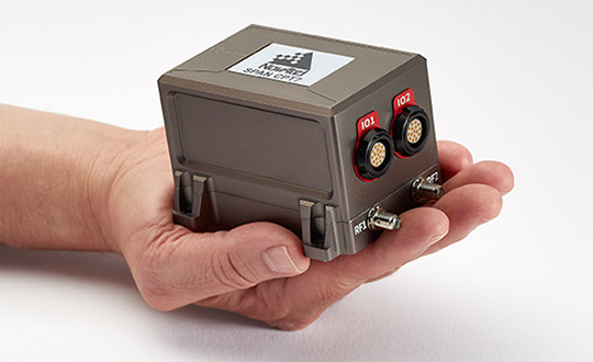
The SPAN CPT7. (Photo: NovAtel)
The firmware works best with the recently launched TerraStar-X correction service, which delivers accuracy and reliability, as well as the OEM7, SPAN CPT7 and PwrPak7 products, which use signals from all GNSS constellations and frequencies to provide users with reliable autonomy and exceptional positioning availability.
The 7.07.03 firmware offers a significant improvement to the SPAN GNSS + INS (inertial navigation system) technology. SPAN with 7.07.03 shows improvements of up to 20% in the horizontal position over the entire SPAN IMU catalog and across various industry use cases including agriculture and marine. SPAN with 7.07.03 also provides improved motion detection, resulting in more robust time to convergence.
“The 7.07.03 firmware features improvements to both our SPAN Marine and SPAN Rail profiles that will greatly impact application performance and consistency,” noted NovAtel Director of Product Management, Neil Gerein, “The SPAN Marine Profile sees improvements to the heave performance and will allow users to start their work significantly faster thanks to a simplified setup for applications in marine dynamics. The SPAN Rail Profile improves position accuracy over long GNSS outages, which is crucial for applications in rail environments that often deal with potential signal obstructions such as trees, tunnels and dense urban areas.”
To download the 7.07.03 firmware update for your platform, click here.
GNSS positioning algorithms combined with automotive-grade GNSS chipsets, inertial measurements and GNSS corrections services from a ground network of reference stations can deliver instant lane-level accuracy.
By Tasha Wong Ken and Sara Masterson, Hexagon Positioning Intelligence
Autonomous technology is reshaping the future of the automotive industry and Hexagon’s Positioning Intelligence Division (Hexagon PI) is developing cutting-edge positioning solutions to support the growth of this rapidly changing industry.
Hexagon PI is working with GNSS chipset manufacturers like STMicroelectronics to deliver automotive-grade, multi-frequency GNSS chipsets that combine our positioning algorithms with automotive-grade GNSS hardware to deliver solutions for connected cars, advanced driver-assistance systems (ADAS) and autonomous driving applications.
In June, Hexagon PI introduced TerraStar X GNSS correction technology, which enables lane-level vehicle positioning in under a minute, using automotive-grade chipsets and the Hexagon PI positioning engine. Built on the company’s latest precise point positioning (PPP) algorithms, TerraStar X leverages existing Hexagon capabilities in ground network infrastructure, correction data generation, and data packaging for delivery.
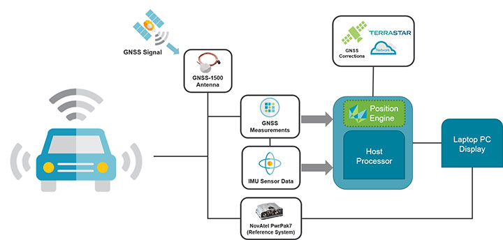
FIGURE 1. TerraStar X correction data generation and delivery to the vehicle. (Image: Hexagon PI)
By combining Hexagon PI’s software positioning engine with GNSS measurements from automotive-grade chipsets and inertial measurement unit (IMU) data, TerraStar X GNSS correction services can deliver instant lane-level accuracy positioning.
TerraStar X combines existing TerraStar global clock and orbit data with regional ionospheric correction data from Hexagon’s vast network of SmartNet reference stations. This forms the technology foundation for future correction services on connected cars, ADAS and autonomous driving markets, including integrity and authentication for safety-critical applications.
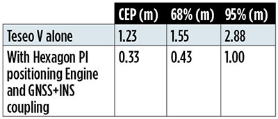
FIGURE 2. The Hexagon PI positioning engine achieves seamless position accuracy by taking GNSS measurements from the Teseo V GNSS receiver, combining it with their positioning algorithms, GNSS+INS coupling, and TerraStar X correction technology. (Image: Hexagon PI)TABLE 1. Cumulative distribution of horizontal errors from testing on German roads. (Table: T. W. Ken and S. Masterson)
HxGN SmartNet consists of a large operational reference station network, consisting of more than 4,500 stations with continuous quality monitoring and support. Correction data generation takes place at Hexagon processing centers where service reliability, redundancy and 99.999% guaranteed service uptime ensure corrections are available for users 24/7/365.
While TerraStar X utilizes the stations already available, the algorithms are flexible and will accommodate the rollout of new service areas with increased station separation, enabling continental-scale coverage.
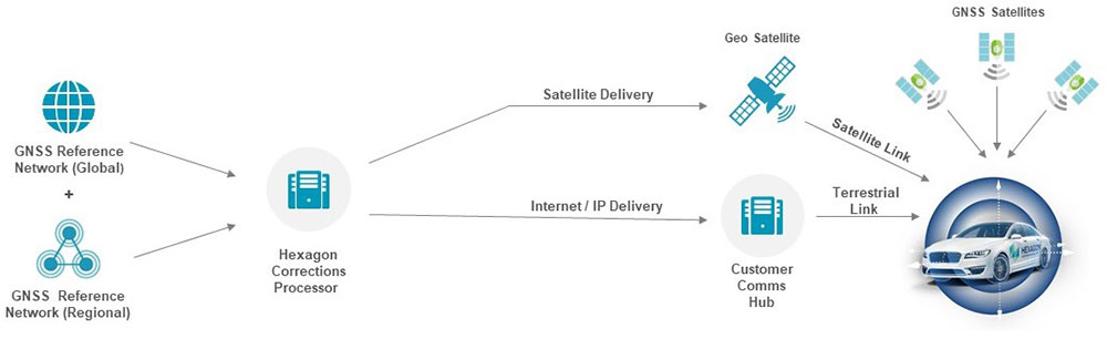
TerraStar X technology will deliver correction data to vehicles and end users through hybrid delivery channels, including both cellular network and satellite. Combining TerraStar X technology with multiple delivery channels ensures that vehicles, UAVs, industrial vehicles, trains, and more will operate safely, securely, reliably, and efficiently.
TerraStar X testbeds are being utilized for several advanced automotive development programs in North America and Europe, TerraStar X commercial services will be available in 2019. Interested customers can request access to any of the testbeds through Hexagon PI.
Positioning Engine. Hexagon PI’s positioning engine architecture enables a flexible integration with different GNSS receiver chipsets, augmentation sensors and processor environments, providing automotive manufacturers with additional flexibility when it comes to sourcing components and subsystems of ADAS and autonomous driving solutions.
The positioning engine is being developed to Automotive Safety Integrity Level (ASIL)-B standards and will include a proprietary GNSS integrity solution to ensure safe positioning within defined protection limits tailored to the customer’s application requirements.
Recent test results
Hexagon PI conducted demonstrations in Michigan and Germany using an automotive platform that combined automotive-grade GNSS hardware with TerraStar X technology and the software positioning engine to demonstrate instant lane-level accuracy with correction data delivered over the cellular network to test vehicles.
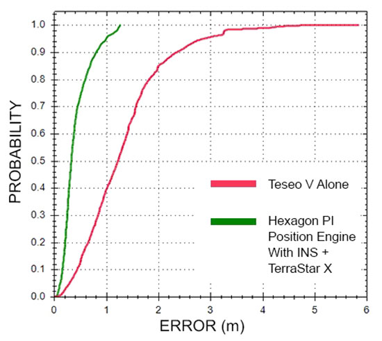
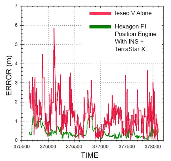
The results are from the most recent demonstration performed in urban conditions in Germany. The route consisted of a mix of controlled-access highway and light urban roads in the city. In this case, the positioning engine using TerraStar X and GNSS+INS coupling deliver 1-meter accuracy through 95% of the dataset.
FIGURE 3. Cumulative distribution of horizontal errors from tests on German roads. (Figure: T. W. Ken and S. Masterson)
Throughout the data collection, position accuracy improves by almost 70% when TerraStar X and the positioning engine is used. In some areas, it was found that the position solution can improve up to 95% with the Hexagon PI positioning solution over the standalone Teseo V, an automotive-grade GNSS receiver from STMicroelectronics.
FIGURE 4. Horizontal position errors from testing on German roads. (Figure: T. W. Ken and S. Masterson)
Looking ahead in automotive
Hexagon PI continues to demonstrate the benefits of precise positioning on automotive-grade chipsets using augmentation sensors, our positioning engine, and TerraStar X technology in a variety of environments worldwide. Our goal is to develop a solution for mass-production that provides accurate and functionally safe positioning to enable the advancement of autonomy in the automotive industry.
“In partnership with Ligado Networks, we have demonstrated delivery of TerraStar X technology over both satellite and cellular networks to position vehicles with 5-centimeter (2-inch) accuracy in under a minute,” Hexagon stated in a press release. “Combining TerraStar X technology with multiple delivery channels is a significant step towards the future of Autonomous X, where cars, UAVs, industrial vehicles, trains and more will operate safely, securely, reliably and efficiently.
TerraStar X technology is built on the latest precise point positioning algorithms. According to the company, it leverages existing Hexagon capabilities in ground network infrastructure, correction data generation and data packaging for delivery.
By eliminating convergence time while providing high-accuracy global positioning, TerraStar X will form the future of Hexagon’s correction services for safety-of-life applications and Autonomous X.
When combined with automotive-grade GNSS receivers available through Hexagon Positioning Intelligence, the technology allows automotive customers to evaluate positioning performance in real time using data delivered over the cellular network or the L-band frequency using Ligado’s SkyTerra satellite in North America.
Trial networks for customer evaluation are available in California, Arizona and Michigan over satellite or cellular network, and in Germany using cellular delivery. The infrastructure is scalable, enabling timely geographic expansion to accommodate automotive development programs globally.
Commercial solutions designed for the automotive market will be available in 2019.
“Ligado’s expertise in satellite delivery and proactive involvement in this project enabled rapid deployment of our TerraStar X correction technology over the test area,” said Sara Masterson, positioning services segment manager with Hexagon’s Positioning Intelligence division. “Their unique spot-beam technology enables efficient delivery of the higher bandwidth correction data required for this application and adds a delivery method providing continental scale coverage.”
The geostationary Skyterra satellite operated by Ligado uses a 22-meter reflector-based antenna to deliver an L-band signal over North America. Several of the L-band DGPS/PPP service providers, including Terrastar, have used the Skyterra-1 satellite since its 2010 launch to support North American coverage.
Hexagon has been providing highly reliable, precise GNSS corrections under VERIPOS, TerraStar, Oceanix, and SmartNet brands for more than 20 years, the company said. It operates the world’s largest reference station network, consisting of more than 4,500 stations.
“Hexagon is uniquely positioned to offer end to end solutions from correction data generation through to GNSS positioning solutions in the vehicle,” said Brian Deobald, vice president, strategic product and ecosystem development, Ligado Networks. “We are excited to partner with Hexagon on this opportunity to demonstrate the delivery of TerraStar X technology, using high throughput, cost-efficient satellite connectivity to enable superior performance and reliability for autonomous driving applications.”
Ligado. This development has no relationship to the current Ligado Networks petition before the Federal Communications Commission to repurpose some of its mobile satellite systems spectrum to broadcast from ground-based transmitters. That matter is still pending, and there is currently no such signal being broadcast.