Tersus GNSS Inc. has launched the David Plus — a dual-antenna GNSS receiver that offers centimeter-accurate positioning and heading. It is designed for intelligent transportation, construction, machine control, precision agriculture and navigation applications.
David Plus is designed for efficient and rapid integration. The compact, lightweight receiver tracks GPS, GLONASS and BeiDou signals: GPS L1/L2, GLONASS L1/L2, BeiDou B1/B2 from the primary antenna, and GPS L1/GLONASS L1 or GPS L1/BeiDou B1 from the secondary antenna.
The modular and flexible design can provide robust positioning and heading accuracy in a compact footprint for UAVs and other smaller autonomous projects.
The David Plus GNSS receiver is built for outdoor environments with IP67-rated enclosure. Its compact palm-sized design makes it easy to integrate with various application systems.
Four gigabytes of in-built memory are available to record data for post-processing.
The David Plus GNSS receiver supports RTK positioning mode or RTK positioning + heading mode. It supports 384 channels. It’s easy to connect an external powerful radio for long range communication.
Tersus GNSS Founder & CEO Xiaohua Wen introduces the company’s new Oscar RTK receiver line at Intergeo 2018, which took place Oct. 16-18 in Frankfurt, Germany.
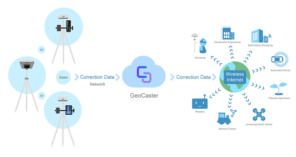
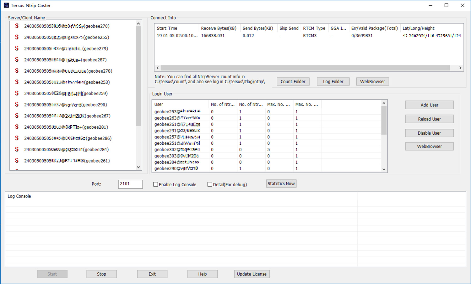
Tersus GNSS Inc. has released the Tersus GeoCaster, a Networked Transport of RTCM via Internet Protocol (NTRIP) caster software. The software expands the company’s product line and provides users with better and more comprehensive services.
The Tersus NTRIP caster software is designed to allow GNSS correction data such as RTCM corrections to be repeated and sent to different end users via the internet.
Screenshot: Tersus GNSS
“GeoCaster has a user-friendly interface, and it not only supports multiple bases online simultaneously but also supports multiple rovers for one base,” said Xiaohua Wen, founder and CEO of Tersus GNSS Inc. “Our users can have a real-time review of detailed statistics and can modify user-defined permissions manually.”
Tersus GeoCaster supports configurable bases online simultaneously and configurable rovers for one base. GeoCaster supports NTRIP protocol and operates continuously.
The software is designed for end users involved in applications such as surveying, construction engineering, deformation monitoring, automated vehicle, precision agriculture, unmanned aerial vehicle, machine control and robotics.
This is the first release of GeoCaster. Version 2.0, targeted at the first quarter of 2019, is expected to offer higher accuracy and longer baseline applications.
Tersus GNSS Inc. has launched Tersus Oscar, its new generation GNSS real-time kinematic (RTK) system.
Oscar is an all-in-one GNSS receiver that can be used as rover or base system. Paired with a Tersus TC20 controller or A11 mobile terminal, Oscar can more efficiently meet customer application requirements for the optimal surveying solution, according to Xiaohua Wen, founder and CEO of Tersus GNSS.
“Last year, we launched the David GNSS receiver,” Xiaohua said. “This year, we are very excited to introduce an advanced version of David; we named it Oscar.”
Oscar supports calibration-free tilt compensation function, meaning a leveling pole is no longer required. Configuration is made easy with a 1.3-inch interactive screen. With an internal high-performance multi-constellation and multi-frequency GNSS board, the Oscar GNSS receiver can provide high accuracy and stable signal detection, the company said.
The high-performance antenna can speed the time to first fix and improve anti-jamming performance. The built-in large capacity battery can support up to 10 hours of fieldwork.
A radio module in the package supports long-distance communication. With its rugged housing material, Oscar is protected from harsh environments.
Tersus GNSS Inc., a GNSS positioning solution provider, has introduced three new GNSS kits. The BX305, BX306 and BX316 HRS kits feature high-precision BX305, BX306 and BX316 GNSS RTK boards.
The HRS kits consist of RTK receivers, GNSS antennas, RS05R radio station modems, radio station antennas, and related cables and converters.
Tersus GNSS BX305-HRS kit.
Tersus GNSS BX306-HRS kit.
Tersus GNSS BX316-HRS kit.
Embedded in the receivers are the Tersus RTK boards. They are compact-design, energy-efficient, centimeter-level accurate GNSS real-time kinematic (RTK) boards, bringing high-precision positioning accuracy to the market, the company said.
Different from the standard BX305/306/316 GNSS kits, the new HRS versions are equipped with RS05R, lightweight and robust UHF, which is a rover radio solution for wireless application.
It provides reliable data communication for demanding conditions that require a combination of stability, high performance and long-range operation.
With complete components and accessories in the kits, they can be used in a variety of applications, such as unmanned aerial vehicle (UAVs), surveying, mapping, precision agriculture, construction engineering and deformation monitoring.
Tersus David RTK is a real-time kinematic solution for centimeter-level accuracy using a smartphone. By plugging into a smartphone with a USB cable, The Tersus David turns the phone into an RTK rover, geographic information system (GIS) collector and RTK base. It supports GPS L1/L2, BeiDou B1/B2 and GLONASS G1/G2 signals. The rugged design enables it to operate in harsh environments.
The Riegl VMX-2HA is a high-speed, high-performance dual-scanner mobile mapping system that provides dense, accurate and feature-rich data at highway speeds. With 2 million measurements and 500 scan lines per second, the turnkey solution is suitable for survey-grade mobile mapping applications. The powerful technology in the Riegl VMX-2HA is comprised of two Riegl VUX-1HA high-accuracy lidar sensors and a high-performance INS/GNSS unit housed in an aerodynamically shaped protective cover. A camera interface for up to nine optional cameras enables the lidar data to be complemented by precisely georeferenced images.
The ZEB-REVO RT is the next generation of the ZEB-REVO — GeoSLAM’s lightweight, handheld laser scanner that allows rapid, simple mapping of complex, indoor and multi-level spaces. The ZEB-REVO RT uses Wi-Fi technology to seamlessly connect the scanner to a mobile phone or tablet, allowing for real-time data visualization as the user walks and scans. The simultaneous scanning and processing of 3D data removes the need for post-processing, effectively slashing project survey times in half. The technology is so rapid, users can scan and process a three-story building in 30 minutes.
MapAnything Connector for ArcGIS gives users a map view of Esri ArcGIS Online data inside Salesforce with their organizational data for strategic planning and analysis. The add-on app serves as a bi-directional integration layer between the programs, enabling customers to access their ArcGIS mapping and location intelligence inside the MapAnything Platform. Once connected, the MapAnything user interface helps Salesforce users view and interact with Esri maps and data alongside their existing customer and business data, exposing new opportunities to drive revenue and increase efficiency; improve decision making by aligning two core systems of record, the GIS system and the customer relationship management (CRM); and make it easy for GIS professionals to share insights seamlessly with their counterparts. The application has uses across retail, commercial real estate, telecommunications and economic development.
Generates Realistic Test Scenarios for a wide variety of applications
The SMW200A GNSS simulator can be extended to up to four RF outputs and allows GNSS signals to be simulated simultaneously in multiple frequency bands for multiple antennas. It can internally simulate a complex interference environment in parallel with GNSS signals. To test multi-frequency and multi-antenna systems, users have access to 72 GNSS channels that can be assigned to up to four RF outputs. The SMW200A can generate QZSS and SBAS signals as well as GPS, GLONASS, Galileo and BeiDou signals, enabling users to quickly and easily verify the position accuracy of their receivers under realistic conditions. An internal noise generator can generate complex interference scenarios with multiple interferers.
Multi-frequency, four constellations for survey and GIS
The Altus NR3 is a multi-frequency, quad-constellation (GPS, GLONASS, BeiDou and Galileo) RTK receiver for survey and GIS applications. It features Septentrio’s AIM+ interference mitigation and monitoring system, allowing continued operation in the presence of both intentional and non-intentional interference. It combines advanced GNSS features with a robust communications suite in a compact, low-power and easy-to-use unit. The Altus NR3 is configurable as either a rover or a base station. It offers one-touch logging and Septentrio’s on-board web interface so users can monitor and configure the unit as well as collect data using any Wi-Fi-capable device.
VersaPNT provides virtually failsafe battlefield navigation, even in GPS-denied environments, to protect critical networks. The new, ground, air or sea vehicle-mounted unit is designed for military environments, with a ruggedized, compact, low-power and lightweight form factor. It provides continuous mission assurance and command, control, communications, computers, intelligence, surveillance and reconnaissance (C4ISR) support, even in hostile environments.
The SyncServer S650 SAASM server incorporates a Selective Availability Anti-Spoofing Module (SAASM). The SAASM capability provides a highly secure, accurate and flexible time and frequency platform for synchronizing mission-critical electronics systems and instrumentation applications in the defense market. The SAASM received the GPS Directorate security approval to incorporate a military-grade, GPS SAASM receiver module, enabling U.S. armed forces to deploy features of the commercial SyncServer S650 in a military-grade configuration and allowing for a migration path to GPS Military Code (M-code) support.
Superior multi-constellation tracking for uavs, survey vessels
The multi-constellation D-Helix Antenna is capable of superior tracking of signals from GPS L1/L2 L-Band, GLONASS L1/L2, BDS B1/B2/B3 and Galileo. The quadrifilar helix design of low wind-resistance makes it suitable for UAV positioning and navigation. The increased antenna gain and beamwidth ensure better signal receiving performance at low elevation angles; the low noise design also reduces interference and improves signal quality. The antenna can be used in UAV patrol, UAV plant protection and for unmanned patrol and survey vessels.
Helps enterprises efficiently manage their drone operations
FlightHub is a new software solution that helps enterprises and drone service providers efficiently manage their drone operations from a single platform. A web-based service, FlightHub enables the secure management of real-time drone operations, flight data, drone fleets and pilot teams to meet the needs of the expanding global commercial drone industry. Users can view their teams’ remote drone operations from one place in real time.FlightHub provides enterprises a clear, centralized view of their company’s drone operations to enable onsite pilots to more effectively collaborate with offsite teams. The Map View and Real-Time View features display telemetry, camera and sensor data for faster, more informed decision making.
The new MR6442AX IP 4MP dome camera is suitable for demanding outdoor installations in challenging lighting conditions, such as schools, parking lots and sports stadiums, as well as city and perimeter surveillance. It features brilliant video quality, a 2.8 to 12 mm Varifocal-Auto iris lens, 100-db high dynamic range (HDR) and built-in Sense up+ low light technology. Intelligent video surveillance (IVS) functionality is a cornerstone of LILIN IP M-aeries cameras. The MR6442AX IVS analytics include advanced motion detection, object counting and tripwire detection, allowing the camera to detect when an object or person has breached an area such as the entrance to a building or parking lot. The MR6442AX is outdoor-ready out-of-the-box with an IP66 rating for rain and dust resistance, suitable for perimeter protection where early detection of an intrusion attempt is critical.
The Parrot Bluegrass Agricultural Solution includes a powerful quadcopter equipped with a full high-definition front camera and embedded Parrot Sequoia advanced multispectral sensor; flight planning mobile application with Pix4Dcapture; data processing with AIRINOV FIRST+ cloud platform; and a long-range remote control, the Parrot Skycontroller 2. Parrot Bluegrass is easy to set up , fly and repair, with Pix4Dcapture autonomous flight capability. It can automatically cover up to 30 hectares at 70 meters / 230 feet flight altitude per battery (25 minutes per battery).
Automatically detects, locates, tracks and takes over UAS controls
The Airfence 5.0 UAS countermeasure platform, updated from Airfence One, provides new and improved directional finding along with detection, tracking and long-distance jamming capabilities. It is designed to protect militaries, airports, prisons and private companies from rogue drones in illegal and potentially life-threatening situations. Airfence 5.0 is certified rugged and offers compact out-of-the box setup and installation. The update incorporates lessons learned from key projects with the FAA, NASA, the U.S. Marine Corps and the European Commission. Airfence 5.0 includes updates focused on increasing the detection rate and level of data packets received, enabling for real-time actionable insights.
The HumX plug-in turns older model autos into smart cars. It equips the cars with features like using GPS for roadside assistance, Wi-Fi hotspot for up to 10 devices, maintenance reminders and auto health diagnostics. HumX uses safety features such as speeding and boundary alerts, vehicle diagnostics, driving history and emergency assistance (with crash detection capabilities). It allows travelers to stay safe with pinpoint roadside assistance, turn-by-turn navigation, live traffic updates and a mechanics hotline for certified, expert advice. HumX is sold with an equipment fee, a one-time activation fee and a monthly subscription.
Enables fleets to improve safety, productivity from a Samsung device
Omnitracs and Samsung Electronics America are partnering to help the transportation industry address the Federal Motor Carrier Safety Administration (FMCSA) Electronic Logging Device (ELD) Mandate. The solution combines Samsung smartphones, tablets and security solutions with Omnitracs’ XRS fleet management software to improve safety, data security and productivity for U.S.-based fleets. Drivers can use their mobile device to monitor hours of service (HOS) logs to comply with legal requirements during on- and off-duty management of vehicles. Electronic tracking of HOS increases speed and accuracy of reporting, because drivers can track their hours in real time instead of fixed increments, such as in manual entry methods. The solution provides fleets with key driver performance analytics, including fuel usage, drive time, speed, driving behavior, driver vehicle inspection reporting (DVIR) and trip data to improve driver safety, lower costs and increase productivity.
Tersus GNSS Inc. has announced the BX316D to extend its GNSS OEM RTK PPK board and offer more compatibility to the market.
BX316D is a GNSS real-time kinematic (RTK) OEM board for accurate positioning and heading. It is able to integrate with other host devices or to serve as an independent positioning system. The versatile interface and log/command formats make it compatible with major GNSS OEM boards in the market, the company said.
Key Features
Supports RTK positioning mode or RTK positioning+ heading mode, and modes are software configurable
Up to 20Hz RTK solution and raw data output
Supports IMU raw data output
Pin-to-pin compatible with Novatel OEM617D
LOG & Command compatible with Novatel Protocol
Supports PPS output and event mark input
Serial ports with LVTTL level
External antenna input through MMCX connectors
Data output: NMEA-0183 and Tersus Binary format
Correction: RTCM 2.x/3.x/CMR/CMR+
Easy to integrate with Pixhawk and other autopilots
Over the past two years, I’ve been sharing my view on land surveying over a variety of topics. One of the constant themes I try to maintain is technological improvements and how surveyors need to continue to embrace new applications and equipment.
While I will also argue that we cannot forget our surveying roots (see GPS World, March 2017), we still need to keep an eye on future technologies, means and methods to increase our productivity and profitability as well.
With this idea of peeking at the road ahead, I traveled to Berlin, Germany, to cover Intergeo 2017, an international trade show for everything geospatial.
Held every year at different venues around Germany, Intergeo is the world’s largest conference and exhibition for geodesy, geoinformation and land management. The theme of the conference this year was “We are bringing worlds together,” and based upon the number of vendors, new equipment and applications, and record breaking attendance, it was quite evident they hit their mark.
The numbers were astounding: 580 vendors from 37 countries, 18,000+ visitors from 100+ countries, all packed in six interlinking halls covering more than 325,000 square feet (7.5+ acres). When I spoke with several contemporaries who previously attended Intergeo, all warned me to be ready for the size and scale of the facility, the number of vendors, and the large spaces occupied by the big survey players. Truly thinking this rhetoric was hyperbole, I went with guarded expectations. Boy, was I in for big surprise.
Walking up to the entrance, one could sense immediately the size and enormous presence of this conference. The registration lines were easy and efficient, with plenty of entry gates and attendants to help with any information. When I entered the first hall for my initial visit, the prior warnings about the size and scale were quite true. This conference was three days long, and I knew I was going to need every minute to cover all the bases.
My account here is broken into four sections — one hall per day. Leica, NovAtel, Laser Technology and Septentrio were among the first booths I encountered on day one. Javad, ComNav, Hemisphere and Emlid were in the next hall over, and can be found below “Behind Door Number Two.” Day three found me hobnobbing with CHC Navigation, EOS and Swift Navigation; look for them under “I’ll Take Hall Three for $200, Alex.” I topped off my Intergeo experience interviewing NavCom, Tersus and Trimble in “The Big Finish (Or Is It?)”
ENTERING ANOTHER DIMENSION…
Coming into Hall 1.1, the first thing that catches one’s eye besides the vastness of the entire space is the size and depth of the Hexagon exhibit. Hexagon is the parent company of Leica, NovAtel, and several others, and all were there displaying new products and software for a multitude of geospatial needs.
I was introduced to the new Leica GS18T GNSS RTK rover (Leica Geosystems debuts GNSS RTK rover at Intergeo 2017) with many new upgrades, including being able to measure a point while the unit is not being held plumb. Yes, you read that right; the unit has an inertial measurement unit (IMU) built in that compensates for any rod tilt and corrects the location back to the bottom of the rod. Now it is possible to collect a GNSS location to places and objects no longer thought possible.
This feature has been available with the “J-Tip” from Javad for the past year: now Leica has added the capability to the GS18T.
While the demonstration took care of my skepticism of the unit, it raised different concerns with the field personnel using it. This method of “no bubble” is fine for this unit, but I can envision crews getting sloppy with conventional GNSS and total station prism rods when mixed with this new technology. This will increase the need for proper training and trust that the all rod-based equipment is used in its intended manner and procedure.
NovAtel was on hand with presentation of a full line of GPS receivers, boards and peripherals, including its GAJT line of anti-jamming receivers as well as an “interference” toolkit of analyzing software modules. With the solid product line and software, the company motto of “assured positioning” bodes well for its users.
Laser Technology Inc. has provided many measurement breakthroughs over the past few decades, and its introduction of the TruPoint 200h is no exception (see Laser Technology highlights TruPoint 200h at Intergeo 2017). The company has taken the TruPoint 200 line of measuring devices and expanded its capability with phase shift and pulse diode measurements, which means the unit will determine the most accurate method based upon reflectivity. This is also paired with a data collection and reporting application on your Android smartphone to greatly expand your ability to share your data.
Also at Intergeo introducing a new GNSS receiver was Septentrio, a navigation systems developer from Belgium. Septentrio was showing the Altus NR3, a lightweight multi-constellation receiver aimed at the surveying and mapping community. This new unit boasts an AIM+ system designed to monitor and protect the user’s data from jamming and spoofing so the collected data is confidently accurate.
Carlson displayed its new BRx6 multi-GNSS receiver along with the RT3 tablet data collector. The BRx6 receiver expands the Carlson family of GNSS products to include connection to most RTN systems worldwide as well as the Atlas L-band correction service that is beginning to gain many followers. Paired with the new RT3 tablet, these products continue the look, feel and service that Carlson users have enjoyed for many years.
Sokkia was there with a full complement of surveying and monitoring equipment, with the GCX3 GNSS receiver being the main focus of their new products. This unit sets the bar even higher for light and efficient GNSS receivers as it weighs only 440 grams with the batteries, yet is more capable than many similar systems on the market.
Another new GNSS receiver introduction was from Hi-Target, the iRTK-5. This new model is the one of the first units to have an OLED touchscreen on the receiver. It supports reception from all major GNSS constellations as well as the L-band correction service. Hi-Target prides itself on a new proprietary differential correction technology that analyzes the integrity of data from all sources before providing a position. This model also has a 4G LTE chipset that will communicate with almost all cellular systems worldwide.
One thing that stood out to me that differs greatly from surveying in the U.S. is the proliferation of monuments and monitoring points/devices used by surveyors throughout the world. So, the multitude of vendors offering varying kinds of targets, prisms, and survey point markets should not have shocked me, but it still did. It was quite impressive with the walls of targets and prism assemblies for many different applications along with the tables of nails, tablets, monuments and vault systems used by surveyors worldwide. Among the notables were Rothburcher Systeme and Bohnenstingl, who both offer a complete line of products beyond most surveyor’s imaginations.
The Juniper Systems booth showcased the Mesa2 rugged tablet and the Geode sub-meter GNSS receiver, both designed with efficient mapping collection in mind at an affordable price point, yet rugged enough to take on most environments. They were also highlighting their CT5 rugged smartphone and CT7G rugged tablet as solid products for any surveying and mapping data collection need.
BEHIND DOOR NUMBER TWO
After navigating the first of four conference areas, I wondered if all the remaining halls would be just as impressive. Hall 2 did not disappoint, as the exhibit spaces were just as big and remarkable as the first one.
Already a major entity within the GNSS community, Javad came to Intergeo 2017 to introduce its entry into the UAV market, the Triumph F-1. Unlike other UAVs, this unit was designed starting with the GNSS engines Javad is known for; engineers then built the flying craft around the brains of the system. It utilizes the same DNA of the Triumph-LS receiver along with ease of Javad software, all on a multi-rotor platform with hot-swappable batteries.
Aimed for more agricultural users, ComNav introduced a lightweight GNSS receiver, the T30, and a new software guidance system compatible with most tractor configurations. This system is designed to be more efficient and precise than OEM tractor guidance as well as more customizable for the user.
The company behind the new Atlas L-band correction service, Hemisphere GNSS, also provided introductions to several new products at Intergeo. In addition to several navigation chipsets for OEM use, they also introduced the 321+ GNSS Smart Antenna. This new receiver is multi-frequency and multi-GNSS with an Athena RTK engine and Atlas L-band global corrections to cover most positional needs. With hot-swappable batteries, this unit will run over 12 hours on two sets that are provided.
EMLID may be a newcomer to the GNSS environment but they are making noise by offering new products and technology at price points for more consumers. At Intergeo, they were demonstrating the Reach RS GNSS receiver with RTK capability, the Reach GNSS module for UAV systems and the Edge module, an advanced drone controller with HDMI video input and 5.8 GHz data link. These guys are my sleeper pick for becoming a bigger player in the very near future.
Topcon’s space, which included industry partner Intel included an interactive dome using their “Immersive Point Cloud Workspace” software and 3D point cloud data to give attendees a virtual reality tour of sites previously mapped with Topcon equipment and software. This four-meter dome was a popular stop with visitors, as was the product introductions of their SmoothRide software and the MAGNET Collage desktop mass data processing software. In addition, another product showcased in conjunction with Intel was their UAV systems, led by the Sirius Pro fixed wing vehicle and the Falcon 8 multi-rotor vehicle.
The main presentation from Bentley to the surveying/GNSS community was the increased capability of their ContextCapture software module. With 3D point clouds and virtual reality systems become the norm, Bentley has upped their game with visualization tools and features within this module not found in many point cloud software packages. The biggest improvement is the ability for survey-grade data acquired through laser scanning, LiDAR and photogrammetry to be easily input and manipulated for many different uses. From BIM to roadway corridor modeling and asset management, these improvements are making the utilization of 3D data more seamless.
Something that caught my eye initially as a novelty was TinyMobileRobots, a Danish company producing a small unmanned cart for marking surfaces. They currently have three products: the TinySurveyor, the TinyLineMarker, and the TinyPreMarker. All have GNSS receivers that operate autonomously on a predetermined route and carry a paint can for marking specific points. From marking athletic fields to paint striping, they might be on to something quite unique but very cool.
I’LL TAKE HALL THREE FOR $200, ALEX
Hall 3 brought us to CHC Navigation and their full range of surveying and mapping products. Highlighted during our discussions with them was the M6, i70 and i80 GNSS receivers and the Apache 5 USV boat for hydrographic applications. It was quite evident how large of a company CHC is and how vast their global presence is so don’t be surprised to see them in North America soon.
EOS Positioning Systems is another smaller GNSS receiver producer that is targeting the mapping community with the lower entry pricing and smartphone application interfacing. From the basic L1 receiver for mapping to the multi-constellation, triple-frequency model including Atlas L-band corrections, EOS is providing an easy to use package at an affordable price point.
Another entry in the OEM board/system provider of centimeter-level accuracy systems is Swift Navigation and their Piksi line of products. From agricultural applications to autonomous vehicle positioning, they are providing navigational systems that will guide our future. As the surveying community expands its use of unmanned vehicles, I would not be surprised to see Swift at the forefront of this effort.
Another member of the Hexagon family, the Geomax display was loaded with everything imaginable for measuring and remote sensing. The main introduction for Intergeo 2017 was X-PAD Office Fusion, an all-in-one software package that allows the data from various sources to come together in one place for creating and manipulating 3D models. While I was not familiar with Geomax, it was quite evident that their customer base, while European-centric, was big and quite loyal to the brand.
A newcomer to the surveying world is Pix4D and their photo processing software. Used by many UAV enthusiasts and now surveyors, Pix4D has quickly become one of the largest providers of software for creating orthometric photos that are georeferenced to known coordinate systems and GIS databases. Most of their success has been because of ease of use and affordability versus the leading surveying software packages. They are also industry partners with Esri and DJI, so having big friends in popular places has helped their cause. Look for more great stuff from them for surveying applications in the near future.
THE BIG FINISH
As I entered Hall 4, I began to wonder if I was done with the major attractions and getting into the bit players. I was wrong.
The first stop was Geozone, who was introducing a new receiver, Falcon SF, through a collaboration with NavCom. This new unit features multi-constellation and multi-frequency collection, but also includes Starfire, a global system designed and maintained by NavCom that is a satellite-based correction signal and provides accuracy of 5 CM anywhere in the world. This correction system comes standard with a subscription when you purchase the receiver, which is unheard of in most surveying environments. This is another product I predict that will be making more of a global presence in short time.
Tersus GNSS was at Intergeo to introduce many OEM navigation boards and an RTK system for surveyors and autonomous control systems. The Tersus David RTK system is designed to turn your smartphone into a high accuracy GNSS data collector. This system is highly durable and compact so it will accommodate many different mapping needs.
Another company that has global reach but not much exposure to U.S. business, South Surveying & Mapping Instruments, wouldn’t give an attendee the impression that they are a small player in the surveying world. Their exhibit space was impressive, ranging from simple theodolites to high accuracy robotic total stations, RTK GNSS receivers and fixed-wing/multi-rotor UAVs.
As lidar technology becomes more available and affordable, a stop at the Riegl booth was a must. They were introducing many new products at the Intergeo 2017 show, including the miniVUX-1DL UAV laser scanner for multi-rotor and fixed-wing aircraft. This little beauty weighs under 3 kg and fits on most scalable UAV platforms.
Another fun item on display was the VMX-2HA Dual Scanner Mobile Laser Scanner, which looks like a high-tech octopus on top of your vehicle. This unit collects 2 million measurements per second as well as 9 x 12MP camera images at various angles. As the miniaturization of technology continues, I see RIEGL continuing to lead the lidar segment well into the future.
Just when I thought I was almost done, I realized that there was one major player left that I had not seen: Trimble. They were in the back of Hall 4 across almost the entire width of the conference space. Everything geomatics, remote sensing, and navigation; it was here in one of the biggest exhibition spaces at Intergeo 2017.
All the latest surveying instruments were here, including the R10 GNSS receiver and SX10 scanning total station. The new items for surveying at this show were numerous; the C3 and C5 mechanical total stations with autofocus, Catalyst software with GNSS receiver for smartphones, the T10 rugged tablet for survey and GIS applications, and OEM receiver boards (BD940-INS, BD992-INS and BD990).
Also included within the Trimble space were Nikon and Spectra Precision branded instruments as well as the latest acquisition, Applanix GNSS-aided inertial movement systems. While Trimble has grown considerably in the past decade, it seems as nothing will slow them down. If they continue to introduce great products and technology, I wouldn’t bet against them.
BUT WAIT, THERE’S MORE…
There were three more halls, with two of them being organizations and information booths. Hall 6, however, has grown into a standalone space as “Interaerial Solutions,” Europe’s biggest UAV show. All the main players were in here (including DJI, DroneDeploy and over 150 more) so almost everything imaginable with UAVs can be found here.
During the conference, the adjacent courtyard was utilized for UAV demonstrations and product introductions. It will be interesting to see in the coming years if this segment of measurement and remote sensing will continue to expand with number of vendors/suppliers or if it will get absorbed by many of the bigger players within the geomatics community.
INTERGEO 2017, IN RETROSPECT
The common theme/message through this gathering was digitalization, “smart cities” and the evolution of the occupations that work within these environments. Intergeo is an impressive gathering of likeminded people discussing how to manage the increasing waves of data through technology, analyzation and thought processing.
While I can’t say that these types of gathering do not happen in the U.S., it is not as obvious as the annual assembly of Intergeo in Germany. The surveying community in the United States needs to hold a similar “summit” to help guide the profession toward its future goals. The one thing I have always appreciated about surveying is how it does embrace technology and forward thinking yet must rely on the past to tell us where we have been.
Digitalization is here and cities will get smarter with or without us, so it’s up to us as surveyors to keep looking forward with the times. Global measurement and navigation will be a big part of that, so let’s put our thinking caps on to see what we learn next.
Until next time, guten tag und gute gesundheit.
A big thank you also goes out to my fellow Intergeo members Ryan Gerard, Mike Joyce, and Allison Barwacz for making this a wonderful experience.
Tersus GNSS Inc. has released a major upgrade to its Precis-BX306 RTK board with new and improved GPS/GLONASS functionality. Tersus GNSS is a manufacturer of high-precision GNSS real-time kinematic (RTK) boards, receivers and systems.
Precis-BX306 Board Easy Kit.
The new version of Precis-BX306 supports up to 20-Hz RTK solution and raw measurement output, which can be integrated with autopilots and inertial navigation units.
With improved algorithms, the new Precis-BX306 demonstrates its ability that the 30-km baseline can be fixed quickly, the company said.
Moreover, the dynamic fix rate shows an advantage comparing to the majority of competitive solutions. Stable fix rate is achieved when it is working under city valley, tree, and other challenging environment.
“The technology changes made in this version give a whole new user experience for our customers,” said Xiaohua Wen, founder and CEO. “With the updated capabilities, the Precis-BX306 is particularly useful for drones, surveyors and geographic information system data users interested in an affordable RTK solution.”
This latest version of Precis-BX306 is pin-to-pin compatible with major GNSS boards in the market, offering a flexible interface. Event mark and PPS are supported as always. All enhanced features demonstrate Tersus’ commitment to the needs of customers who value dynamic accuracy and stability.
The new Precis-BX306 is available for order and delivery immediately, and it will be shown at Intergeo in Berlin, Germany, Sept. 26-28.
Tersus GNSS Inc. has released a new AutoSteer autopilot for agricultural machinery.
The AG960 AutoSteer System is designed to accelerate the application of autopilot for precision agricultural machinery and enhance and optimize operational accuracy and productivity for modern farmers.
By integrating high-precision real-time kinematic (RTK) receiver and software, the AG960 enables agricultural machines to operate in accordance with a pre-set planning path. Using precise GNSS guidance, the hydraulic system of the agricultural machinery is steered by the vehicle controller.
Agricultural machines can operate aligned with the set route automatically, while graphical detailsare displayed on the vehicle display panel. The system is easy to use and applicable for each working cycle of agriculture, such as soil tillage, plowing, building of ditches and ridges, seeding, spraying and harvesting.
Tersus plans to launch a series of solutions that meet the requirements of different farming machines. The AG960 was first commercially deployed in China, and will be rolled out in other regions around the world.
Supports integration of telematics, managed services
The LE940A9 automotive-grade smart module supports LTE Advanced Category 9 (Cat 9) networks. It comes in three multi-band, multi-mode variants, including Voice-over-LTE (VoLTE), and is optimized for automobile manufacturers to deploy next-generation connected car technology in world markets. It features worldwide GNSS support including GPS, GLONASS, Galileo, Beidou and QZSS. The LE940A9 delivers 450-Mbps download and 50-Mbps upload speeds with extremely low latency and advanced security, enabling the next wave of automobile industry’s applications and services that also serve as a springboard for autonomous driving.
Low-power, high-precision, positioning and heading
The refreshed Vector Eclipse H328 is designed for robotics, autonomous vehicles, antenna pointing, marine survey, machine control and any application where high-accuracy positioning and heading is required. The multi-frequency, multi-GNSS H328 is an all-signals receiver board that includes Hemisphere’s new and innovative hardware platform, reducing its overall cost, size, weight and power consumption. It also integrates the Atlas GNSS Global Correction Service. The H328 offers fast accuracy heading of better than 0.17 degrees at 0.5-meter antenna separation and aiding gyroscope and tilt sensors for temporary GNSS outages. The 60 x 100 millimeter module with 24-pin and 16-pin headers is a drop-in upgrade for existing designs using this industry standard form factor.
Wheelchair with embedded 3G module can be upgraded with GNSS
A cellular module is embedded in a personal mobility wheelchair built by WHILL, a Japanese company specializing in innovative products for the mobility industry. The WHILL Model C features cloud connectivity based on a 3G cellular module from u‑blox. The embedded module features worldwide UMTS/HSPA and GPRS/EDGE coverage with a small footprint, also enabling easy and cost‑effective bolting on of a u‑blox GNSS receiver such as the MAX‑7C. The personal electric vehicle combines a sleek design with the latest innovative functionalities, enabling users to live an active lifestyle. As WHILL is looking into autonomous driving for people with disabilities, u‑blox plans to contribute with wireless positioning and connectivity technology.
The OSA 5405 SyncReach is an integrated Precision Time Protocol (PTP) grandmaster and GNSS receiver with a patent-pending dual antenna and receiver to enable the mass roll out of small cells. The new technology has been engineered to provide accurate and affordable phase synchronization for the rapidly growing small-cell market and meet the stringent timing requirements of 4.5G and 5G connectivity. With the OSA 5405, operators can migrate from legacy GNSS RF antennas and cables to standard, cost-effective copper and fiber Ethernet cabling, reducing capital expenditure and operating expenses. Available in both indoor and outdoor variants, the OSA 5405 can be deployed in challenging environments, including urban canyons where GPS signals fail or positioned on indoor windows to avoid multipath signal interference from objects in the building.
The AirPrime WP77 smart wireless modules simplify LPWA deployments for customers developing products that need to connect to multiple networks where different LPWA technologies are supported.
With integrated GNSS for tracking and location-based services, low-power modes and a comprehensive set of interfaces for connecting sensors and companion chips (including Wi-Fi and Bluetooth), customers can develop multi-service platforms for the transportation market, and use the WP77 for applications requiring low throughput and optimized power performance. The WP77 supports both LTE-M (Cat-M1) and NB-IoT (Cat-NB1) with optional 2G fallback, allowing customers to deploy the same device with multiple network operators worldwide. For those deploying in regions where 4G LTE coverage is not as widely available, 2G fallback ensures their devices stay connected to the network.
The INS-T-306 module is a GNSS-aided inertial navigation system that combines GPS L1/L2, GLONASS, BeiDou and a high-performance strap-down system. It is capable of determining position, velocity and absolute orientation (heading, pitch and roll) for any device on which it is mounted. The INS-T-306 aims at facilitating motionless and dynamic applications that need high accuracy, such as vessels, ships, helicopters, unmanned aerial vehicles (UAVs) and unmanned ground vehicles (UGVs). The INS-T-306 uses an advanced GNSS receiver, barometer, magnetometers, micro-electro-mechanical (MEMS) accelerometers and gyroscopes to provide accurate position, velocity, heading, pitch and roll of the device under measure. The unit supports differential GPS (DGPS) and real-time kinematic (RTK). It is able to integrate into the lidar brands Velodyne, Riegl and Faro.
The SafeSky multi-sensor UAV detection and tracking system detects and neutralizes drones in any weather, providing true dome-like protection. A combination of proprietary radar, acoustic, vision and RF sensors enables minimized alarm-rates detection of small drones at a distance of at least 1,000 meters. Its miniaturized, low-power radars are based on proprietary space technology developed with the European Space Agency. All sensors data is fused and the result presented in an integrated software environment. No-drone zones are easily defined. Alarms are issued via SMS, email and in graphical and sound form. The SafeSky application is web-based and can be run on desktop computers and tablets for untethered operation. To neutralize drones, the system uses directive jammers or drone hacking (depending on regulations), forcing the drone to return to its operator or land safely in a controlled manner.
The DATAhawk PPK is an ultra-high accuracy fixed-wing drone package designed for professional surveyors that need maximum geospatial precision. It provides absolute (not relative) survey-grade results within minutes. The drone produces repeatable results. It is equipped with a dual-frequency L1/L2 receiver tracking GPS and GLONASS; 132 hardware channels allow simultaneous tracking of all visible GPS/GLONASS satellites. This system allows the aircraft to fly much further than with an RTK system, once flight camera positions are corrected by combining GNSS recordings of the aircraft with the corresponding information of the reference base station on the ground. The UAV is free of the requirement of a separate, high bandwidth, GPS link to a base station.
The FLIR Duo is the same size and shape as popular action cameras, but features advanced capabilities. Equipped with FLIR’s smallest and lightest Lepton thermal camera core, operators are no longer constrained by daylight. The Duo provides the power to see objects over 100 yards away in complete darkness, smoke and light fog. Equipped with a 160 x 120 thermal camera and High-Definition (HD) 1080 color camera, FLIR Duo allows operators to swap between the two cameras mid-flight or view both in a picture-in-picture mode via the FLIR UAS app. FLIR’s proprietary multi-spectral dynamic (MSX) image processing algorithm embosses the thermal image with key details from the visible camera, resulting in a sharp dual-spectrum image. A fully radiometric variant called Duo R delivers accurate, calibrated temperature measurements in every pixel.
Technology without electronic jamming is safe for urban areas
ApolloShield is a radio system that detects and drives unauthorized drones away at the push of a button. Its RF jammers are field-proven, immediately deployable devices that emit strong signals that break the communications of unwanted drones, driving them away from secure sites. Drone identities are extracted from the radio signal and can be used as a lead to catch the operator. ApolloShield is customizable so that every site will have optimal protection, yet is plug-and-play and can be deployed in a few hours at any location and operated without any special training. The system consists of several elements, including an omni-directional antenna, a signal processing unit (pictured), and the Cloud Control Center that can be accessed from any cloud-connected device (pictured). ApolloShield is designed for various threat scenarios, including surveillance, accident response, terrorism, and incarceration violations using drones.
The Elios drone solves the challenge of flying drones indoors in complex and confined spaces or in contact with humans, reducing the risk of collisions and injuries. By enabling remote visual inspection in any indoor environments, Elios eliminates the need for workers to enter hazardous places or face dangerous situations. The protective carbon-fiber frame is collision-tolerant up to 15 km/h. Elios reduces downtime and performs an entire inspection in hours, eliminating the need for scaffolding, rope access, or cranes for visual inspections of difficult-to-reach areas. Its integrated payload includes simultaneous full HD and thermal imagery recording, and adjustable tilt angle.
The Here+ RTK GNSS kit is an open source drone navigation kit. It is built around u‑blox’ NEO‑M8P high-precision real-time kinematic (RTK) GNSS module. Supported by Ardupilot out of the box, the kit consists of a round rover designed to be mounted on the drone and is connected to the flight controller using a supplied 8‑pin CLIK-mate connector (for the autopilot Pixhawk2) or an optional 4 pin + 6 pin DF13 connector (for the Pixhawk1). The base station with its smaller GNSS receiver and an external antenna complete the equipment. The open-source drone technology is intended to reach a larger community and assist drone companies with affordable accessories for applications such as agriculture, powerline inspection, precision farming, logistics and 3D mapping.
Customizable filters allow for unique crop health detection
The Quad Sensor features four fully customizable imagers for collecting precision agriculture data. In its standard configuration, the sensors offer standard normalized difference vegetation index (NDVI), green NDVI, normalized difference red edge (NDRE) and high-resolution color data capture in a single flight. Simultaneous collection of NDVI and NDRE data provides users with informative, accurate insights about crop health while streamlining operations. Custom filtering options provide virtually limitless configuration options. Because the Quad Sensor allows targeting of specific vegetative indices, it is being used by universities, researchers, large growers and agriculture advisors.
The Airdog ADII builds on the high-performance elements of the original Airdog drone. It combines advanced intelligent tracking technology with a durable design and autonomous, all-terrain flight performance. Built for hands-free operation, the ADII eliminates the need for manned operation, giving the user complete active freedom with perfect content capture. Customizable flight trajectories allow for more dynamic angles and obstacle avoidance, and scenic-capture modes provide unique filming perspectives. Its pro-grade camera stabilization and auto-record system guarantee smooth, framed, professional-grade footage even in challenging environments, such as high speeds, wind, water and abrupt elevation and terrain changes. The durable, lightweight, waterproof AirLeash tracking device allows for hands-free action with simple controls. The backlit LCD interface is loaded with easy flight, start-up tutorials and preset, sport and customizable modes plus a series of automated creative modes for capturing scenery.
Micro Electronic Defense System (OMEDS) for drones, robots
The Pyramid installs easily to fully secure a drone or robot, add system robustness, and provide data for better planning and execution of missions. The Pyramid provides three layers of functionality: advanced security for the system and data with real-time full system encryption and GPS spoofing protection; operational reliability and robustness with RF link redundancy; and mission-enhancing benefits of RF mapping provided by collection and analysis of big data. RF mapping visually maps the datalink’s RSSI and GPS reception for better mission planning and execution. This enables better, safer, continuous autonomous operation in all environments. It includes virus and malware protection, and full system encryption for remote-control, telemetry and video links. Pyramid weighs about 1 ounce (30 grams), measures 2 inches (5 cm) and has no effect on a system’s performance. Regulus is offering a test and evaluation program to customers.
Version 17.1 of the UAS Mapping desktop product now includes an upload-to-the-cloud feature. The upgrade includes the capability to upload any UAS Mapping content to a SaaS-based sharing and collaboration platform. Users can instantly bring their drone/UAS/UAV data online. The upload process is fluently integrated in the workflows of the product, with the required checks and validations. Upload time depends on the internet connection. Once uploaded, the data is immediately available for sharing on 3dmapping.cloud. The new Catalog tool adds insight and overview of all data-collection jobs.
The TruPoint 300 is a fully integrated laser with vertical and horizontal angle encoders capable of producing 3-D, survey-grade measurements. It produces +/–1 millimeter range accuracy. The phase-technology product has a laser diode that emits light pulses with a distinct wavelength and pulse repetition frequency that obtains millimeter accuracy. The fully integrated MapStar Angle Technology makes the Trupoint 300 suitable for GIS, incident mapping, crush analysis, surveying, electric utilities, architecture and construction. It will measure the distance between two remote points and has onboard solutions for volume, height, 2D and 3D area. Professionals can navigate through measured data, routines and menus with a full-color touchscreen.
TerraGo Magic is a custom app designed for both iOS and Android platforms that simplifies the process of designing a custom application for specific clients and needs.Surveying firms can install this tool in their mobile device to enable the specific collection and sharing of important data that can vary as needed. The data can overlay Google and Apple Maps and allow attachments of images and video. The app avoids the time-consuming coding process, and can significantly improve workflow for many firms.
The Vector VR1000 GNSS receiver enables better positioning for machine control applications. Designed specifically for harsh construction environments, the Vector VR1000 — when combined with SiteMatrix software — can empower heavy equipment manufacturers to provide their own machine control and guidance solutions to their customers. It also has a new web user interface. The multi-frequency, multi-GNSS receiver offers real-time kinematic (RTK) positioning and high-precision heading. It has an Athena RTK engine, Atlas L-band corrections and excellent connectivity. With a baseline separation up to 10 meters, users can achieve heading accuracies of up to 0.01 degrees. The 744-channel VR1000 tracks GPS, GLONASS, BeiDou, Galileo, QZSS and IRNSS. Its connectivity features support Ethernet, CAN, internal 400-MHz/900-MHz radio, serial, Bluetooth and Wi-Fi. Integrated L-band adds support for Atlas GNSS global corrections for meter- to sub-decimeter-level accuracy.
Miniaturized for quick collection of as-built reality-capture data
The BLK360 miniaturized 3D imaging laser scanner simplifies collection of as-built reality-capture data for work in architecture, design, construction and engineering, among other vertical markets. It is an easy-to-use and powerful device that enables professionals to capture 360-degree high-dynamic range (HDR) spherical imagery within minutes. Users place the lightweight BLK360 on a level surface or tripod and, with the push of a button, it captures 360-degree HDR spherical imagery and takes a 360,000 points per second laser scan. The BLK360 features +/–4 mm accuracy at 10 meters and an overall 0.6–60-meter range. Within three minutes, the spherical image and laser scan is completed and ready to view in the Autodesk ReCap Pro for mobile app, which runs on an iPad Pro. From there, users can take measurements, add markup and annotations or share onsite data with their colleagues back in the office.
Tersus GNSS Inc. is now offering the INS-T-306, a GNSS-aided inertial navigation system. The INS-T-306 is the advanced module that combines GPS L1/L2, GLONASS, BDS navigation and a high-performance strap-down system. It is capable of determining position, velocity and absolute orientation (heading, pitch and roll) for any device on which it is mounted.
The launch of the INS-T-306 aims at facilitating motionless and dynamic applications that need high accuracy, such as vessels, ships, helicopters, unmanned aerial vehicles (UAVs) and unmanned ground vehicles (UGVs).
The INS-T-306 utilizes an advanced GNSS receiver, barometer, magnetometers, micro-electro-mechanical (MEMS) accelerometers and gyroscopes to provide accurate position, velocity, heading, pitch and roll of the device under measure.
Besides GPS L1/L2, GLONASS and BDS, the unit supports differential GPS and real-time kinematic (RTK). It is able to integrate into lidar (Velodyne, Riegl and Faro brands). The on-board sensor fusion filter, navigation and guidance algorithms, and calibration software inside all make INS-T-306 a commercially exportable GNSS-aided inertial navigation system.