Merger to deliver high-end performance and ultra-accurate timing and frequency products for commercial, critical infrastructure and defense markets worldwide
Orolia has entered into a definitive agreement to acquire Seven Solutions, a global innovator in White Rabbit sub-nanosecond time transfer and synchronization technology. This transaction is subject to customary closing conditions and approvals required by the Spanish government and is expected to close before the end of the year.
This is Orolia’s 11th acquisition in the past seven years.
The merger with Seven Solutions, based in Granada, will enhance Orolia’s portfolio for defense, aerospace, data centers, telecom, financial services, smart grids and other critical infrastructure industries, and will enable the next-generation applications dependent on ultra-precise, resilient timing and frequency technology.
“Orolia and Seven Solutions under one umbrella will combine our world-leading technologies to draw a new frontier in network timing to sub-nanosecond levels, delivering the most robust and accurate resilient PNT solutions for our customers,” said Orolia CEO Jean-Yves Courtois. “Seven Solutions’ long history of delivering cutting-edge time distribution solutions to sectors like telecommunications, smart grids, aerospace, defense and scientific facilities aligns perfectly with Orolia’s DNA.”
Orolia and Seven Solutions will integrate global sales, marketing, product development and operations.
Orolia’s full-scale, modular approach to resilient PNT includes atomic clocks with a combination of GNSS signals protected with interference detection and mitigation technology, together with low-Earth-orbit secure alternative signals. The addition of Seven Solutions’ products will deliver terrestrial sub-nanosecond time distribution from distant and potentially redundant locations.
“We believe the union of our companies will produce the future of time transfer and frequency distribution solutions in terms of accuracy, reliability and interoperability,” said Rafael Rodriguez, chief technology officer and co-founder of Seven Solutions. “Finance, 5G telecommunications, data centers and hyperscalers have new and upgraded functionalities requiring ultra-accurate time distribution accuracy. To maximize interoperability, our solution for time transfer is based on the White Rabbit concept that has been pushed over the last decade to become the basis of the standard high accuracy time transfer profile (within the recent release of IEEE 1588 of precision time protocol).”
Orolia and Seven Solutions are members of the Open PNT Industry Alliance. The international organization focuses on market concepts that strengthen economic and national security by supporting government efforts to implement resilient PNT capabilities for critical infrastructure.
ViaLite GPS Link: Blue OEM module and rack chassis card hardware formats shown. (Photos: ViaLite)
ViaLite is supplying Raytheon Technologies with its GPS over Fiber Extension Kit for Microchip GPS servers. The kit provides mission-critical GPS timing and synchronization for systems requiring extremely accurate clock signals.
Standard transmission distances for the extension kit can be up to 10 km, while solutions are available for distances as long as 50 km.
“The ViaLite kit was chosen for its unique performance with Microsemi’s S650 timing server, along with our best-in-class quality, reliability and support,” said Craig Somach, ViaLite director of Sales North America.
The ViaLite GPS link is designed to provide a remote GPS/GNSS signal or derived timing reference to equipment located where no signal is available, such as inside buildings or tunnels. By using optical fiber instead of traditional coaxial cable, extreme distances are possible with no radio frequency loss and zero introduction of noise.
Accurate and reliable positioning, timing and navigation (PNT) technologies, such as GPS, have become “invisible utilities” that enable many critical applications, including the electric grid, telecommunications, agriculture and port operations. These systems, however, are vulnerable to accident and attack, including cyber threats and jamming.
Therefore, the Science and Technology Directorate of the U.S. Department of Homeland Security and the National Risk Management Center of the Cybersecurity and Infrastructure Security Agency have been working in collaboration with industry and government stakeholders to develop the Resilient PNT Conformance Framework, which provides a common framework for defining resilient PNT systems and addresses strategic risks to U.S. national critical infrastructure. This work is now transitioning to the Institute of Electrical and Electronics Engineers (IEEE) as the Standards Working Group for Resilient PNT User Equipment (P1952) and will help serve as starting resources for the refinement and development of a standard.
By creating common definitions for different levels of resilient PNT systems, this new standard will enable vendors to differentiate their products from non-resilient PNT systems, as well as enable end-users to make deliberate, risk-informed decisions as to which systems are most appropriate for their applications and needs. The development of this voluntary standard will help influence the future design, acquisition and deployment of resilient PNT systems within our national critical infrastructure.
The IEEE standards process is an inclusive one, designed to gather many stakeholders interested in resilient PNT. If you would like to participate in the standards working group, just notify the group’s chair (Shelby Savage at [email protected]) or its secretary (Patricia Larkoski at [email protected]). Voting membership requires sufficient participation in work group meetings.
The development of this voluntary standard will help influence the future design, acquisition and deployment of resilient PNT systems.
After the standards working group votes to approve the draft standard, it will be submitted to the membership of the IEEE Standards Association (IEEE SA) for final approval. The IEEE Standards Balloting Center will then send an invitation to any SA members it knows to be interested in the subject matter of the proposed standard, and anyone answering the invitation affirmatively will have a right to vote on the final standard.
Compared to the early days of GPS, PNT systems have become highly sophisticated pieces of equipment with a multitude of components, both hardware and software, along with associated vulnerabilities. Additionally, with a wide array of stakeholders and a variety of ideas on what PNT resilience means, getting consensus and developing such a standard would be challenging without an established process.
To help address this challenge, DHS developed the Resilient PNT Conformance Framework with input from industry stakeholders to establish baseline concepts on the definition of resilience and necessary behaviors within resilient PNT systems. DHS designed this framework to be outcome-based and non-prescriptive, to encourage industry innovation.
“To address security and resilience, GPS and PNT receivers need to be treated more like computers rather than radios,” said Ernest Wong, technical manager for the Science and Technology Directorate. “The refinement of the Resilient PNT Conformance Framework into industry standards will help to ensure that future PNT receivers are resilient and designed to withstand and recover from threats.”
Editor’s Note: This article does not represent a formal position of P1952 Working Group, Communications Society Standards Committee, IEEE, or IEEE SA.
It said policymakers “could consider selecting the most resilient technologies as the cornerstone of the PNT suite for military missions, rather than defaulting to GPS.”
The 51-page report takes a comprehensive view of alternative PNT policy and leadership across the department. Its findings are an interesting and informative look at issues and efforts.
Increasing demands
The report comes at a time when U.S. forces have been seeing increasing interference with their own and allied GPS-enabled systems. The Organization for Security and Cooperation in Europe has regularly reported that its surveillance drones in the Ukraine have been jammed. Chinese press recently bragged that jamming caused U.S. Navy ships in the South China Sea to switch from using GPS to the Chinese BeiDou system. Additionally, U.S. military commanders have regularly described the Middle East as the most contested electronic warfare area on the planet, in large part because of regular interference with GPS signals.
The GAO study also comes on the heels of a provision in the National Defense Authorization Act (NDAA) for this year which directs DOD to provide non-GPS PNT to combatant commanders by 2023. The act says this timeline is consistent with responding to Joint Urgent Operational Needs, a formal method for commanders to communicate with department leadership. According to some sources, this suggests that the Pentagon has been receiving such requirements from field commanders, but has not responded to them in what Congress considers a timely manner.
Alternative PNT “not a priority,” resisted
Despite chronic GPS signal interference across the globe, outside experts and officials across the DOD told the GAO study team that developing alternative sources of PNT was not a priority for DOD. One example cited was the lack of a central program office.
One expert said, “PNT — It’s everyone’s need, but nobody’s business.” Another expert said, “Everyone wants to use [PNT], no one wants to pay or care for [PNT].” One DOD official characterized alternative PNT as an afterthought. DOD’s PNT Roadmap states that PNT capabilities, despite being mission critical, are not normally considered a key requirement, but rather may be treated as “a second-tier requirement.”
Worse, the report indicated that some forces within the department resist alternative PNT efforts.
According to one DOD official cited anonymously in the report “bureaucratic and political obstacles [represent] the biggest challenges for alternative PNT” and “anything that threatens GPS, such as alternative PNT technologies, faces pushback.”
The report cited another DOD official as agreeing that “there is an impression that the GPS program has a lot of political clout within DOD, and that those trying to develop alternative PNT technologies may face political challenges.”
Realistic requirements
Many missions do not need the accuracy provided by GPS, according to the report. Nevertheless. DOD programs often default to GPS performance standards when developing requirements. Many alternative technologies, while more resilient, are unable to achieve the same accuracy as GPS and therefore fail to meet the over-stated requirements.
Open architecture
Both DOD and GAO see development of modular open system architecture (MOSA) as key to PNT success in the future. This will allow addition of new PNT sources to a platform without the need for a major retrofit. With MOSA, all that would be needed is a new sensor module for the desired PNT source.
The GAO report endorsed this approach and encouraged DOD to institutionalize it with dedicated funding.
Working with industry
Decades of civil GPS use have benefited DOD in many ways. Broad academic and commercial research has resulted in a host of applications and improvements in the size, weight, and power requirements of equipment, as well as lowered costs. These benefits would almost certainly not have been realized at the current scale if the market for GPS equipment and apps had been restricted to military users.
The 2021 NDAA directs the department to “…enable civilian and commercial adoption…” of the GPS alternative technologies it develops for field commanders. The GAO report suggests DOD also work to leverage industry advances in technologies.
Scope and recommendations
GAO’s tasking for this effort did not include examining efforts to make GPS signals and equipment more resilient to disruption, nor use of non-U.S. satellite navigation systems. Neither were non-defense uses of PNT, nor improvements in such things as tactics, techniques, and procedures considered.
The study focused solely on department efforts to complement GPS services.
Six recommendations for policymakers are included in the report:
Increase Collaboration — Consider mechanisms to coordinate across DOD to clarify responsibilities and authorities in prioritizing the need for alternative PNT technologies.
Focus on Resiliency — Consider selecting the most resilient technologies as the cornerstone of the PNT suite for military missions, rather than defaulting to GPS.
Clarify Requirements — Consider opportunities to clarify what level of PNT performance is actually needed for missions, rather than defaulting to requirements that match GPS performance.
Coordinate with Industry — Consider ensuring that DOD and commercial industry coordinate so that industry is prepared to meet DOD’s needs, and DOD can leverage industry advances.
Institutionalize Open Architecture — Consider making the open architecture initiative more permanent, including providing funding.
Analyze Vulnerabilities — Consider having DOD conduct ongoing analysis of vulnerabilities of different PNT systems.
The May 2021 GAO report “Defense Navigation Capabilities: DOD is Developing Positioning, Navigation, and Timing Technologies to Complement GPS” is available here.
Adva’s OSA 5405-MB provides nanosecond timing at a network’s edge. (Photo: Business Wire)
Adva has launched the OSA 5405-MB, a compact outdoor precision time protocol (PTP) grandmaster clock with multi-band GNSS receiver and integrated antenna.
Part of the OSA 5405 series of smart synchronization devices for indoor or outdoor deployment, the OSA 5405-MB ensures timing accuracy by eliminating the impact of ionospheric delay variation. This empowers communication service providers and enterprises to deliver the nanosecond precision needed for 5G fronthaul and other emerging time-sensitive applications.
The GNSS receiver and antenna enable the OSA 5405-MB to meet PRTC-B accuracy requirements (+/-40 nanosec0nds) even in challenging conditions. For the first time, the technology is available in an edge timing device with minimal footprint, helping operators achieve unprecedented accuracy and reliability as they roll out wide-spread small cell networks.
“Our multi-band, multi-constellation GNSS receiver provides an extremely cost-efficient way to achieve PRTC-B UTC-traceable network timing with the levels of accuracy needed for next-generation use cases,” said Gil Biran, general manager, Oscilloquartz, Adva. “By adding this technology to our versatile, small-form-factor OSA 5405 series, we’re offering a route to precision synchronization at the network access without significant investment.”
“A ruggedized design and minimal visibility make our OSA 5405-MB easy to install in almost any outdoor location,” Biran said. “With the power to compensate for ionospheric delay variations and resilience against jamming and spoofing, our compact edge solution really is the key to 5G synchronization.”
The OSA 5405 series is a versatile timing solution for deployment deep in urban canyons, where advanced end applications require stringent synchronization. With its small form factor, the OSA 5405-I indoor variant can be positioned on windows to avoid multipath signal interference.
Offering both electrical and optical interfaces and with cost-effective Ethernet cabling, the OSA 5405 series avoids RF feeds of traditional GNSS installations by integrating an antenna, receiver and PTP grandmaster in a single device.
Ionospheric Delays. With multi-band GNSS technology, the OSA 5405-MB also protects against timing inaccuracies caused by ionospheric disturbance. By receiving GNSS signals in two frequency bands and using the differences between them to calculate and compensate for delay variation, the OSA 5405-MB eliminates inaccuracy and ensures ultra-precise synchronization whatever the space weather conditions.
It can work with up to four GNSS constellations concurrently (GPS, Galileo, GLONASS and BeiDou), increasing the number of observable satellites in urban canyons. A comprehensive set of Syncjack PTP and GNSS jamming and spoofing monitoring features in combination with Adva’s Ensemble Controller and Sync Director assures high synchronization quality and provides transparency for simple operation of large synchronization networks.
The OSA 5405-MB also offers network-delivered timing backup to further mitigate GNSS vulnerabilities and make synchronization more robust and resilient.
The United Kingdom’s National Timing Centre will conduct a two-phase series of funded studies and demonstrations focusing on “innovation in the dissemination and application of resilient time, frequency and synchronisation.”
The first round now being advertised is for feasibility studies of projects costing between £50,000 and £250,000. Total funding for the round is £2M. A briefing for interested parties will be held on April 20.
The second round and remaining funding will be devoted to technology demonstrations.
The UK’s National Timing Centre was established in response to several national studies and concerns about the vulnerability of space-based timing services.
Severe solar storms, called coronal mass ejections, were listed on the UK National Risk Register in 2012. While rare, these events can damage assets in space and on the ground.
Next month marks the 100th anniversary of the New York Railroad Storm. It was so powerful, telegraph offices were set on fire in the U.S. and Europe, fuses were blown, and equipment damaged. Even underwater telegraph cable traffic was affected.
Experts say if such a storm were to strike the Earth today, it would likely damage GPS and other GNSS satellites. At a minimum, it would charge the atmosphere and prevent signals from getting through for days.
Projects that will be considered for the UK competition must be technologies and application areas providing trust, assurance, security and resilience for time distribution.
While supported by Innovate UK, the National Physical Laboratory (NPL), which operates the virtual National Timing Centre, appears to be the primary agent for execution. NPL will offer applicants who are selected to participate in the feasibility study phase free technical consultation up to 12 hours, and free access to highly precise and accurate time signals from four NPL locations in the southeast of England.
Since its inception, the National Timing Centre seems to have concentrated on establishing distributed suites of atomic clocks, probably linked by fiber, as a first step to improving the nation’s timing resilience.
Industry observers have opined that future efforts are likely to focus on wireless distribution.
“Wireless requires less infrastructure and has no user limit,” said one. “It only makes sense they would go there once they feel they have a solid clock foundation.”
The competition is open to UK entities. Applications will be accepted April 19-June 9, with accepted participants notified on July 30.
Critical infrastructure services such as telecommunications, utilities, transportation and defense are of national strategic importance. The U.S. Cybersecurity and Infrastructure Security Agency (CISA) lists 16 such sectors considered vital for security. Presidential Policy Directive 21 (PPD-21): Critical Infrastructure Security and Resilience advances a national policy to strengthen and maintain secure, functioning and resilient critical infrastructure.
Together, positioning, navigation and timing (PNT) are necessary for the functioning of a nation’s critical infrastructure. However, ubiquitous use of GPS as the primary source of PNT information introduces vulnerabilities. CISA, through the National Risk Management Center, works with government and industry partners alike to strengthen the security and resiliency of the national PNT ecosystem in the U.S. In early 2020, Executive Order (E.O.) 13905 on Strengthening National Resilience through Responsible Use of Positioning, Navigation, and Timing (PNT) Services was signed to strengthen, through policy promotion, the responsible use of PNT services by government and infrastructure operators.
The following is a review of cost considerations and exploration of the three key elements for critical infrastructure that help to strengthen PNT, focused on synchronization and precise timing: redundancy, resiliency and security.
Evaluating Cost and Location
It is often hard for operators to justify the resiliency, redundancy and security costs associated with deploying these capabilities at every layer of the architecture. New timing and synchronization solutions and design choices are leading to the right cost structures to deliver robust and reliable solutions.
The dilemma between cost and solution type is typically related to which deployment location is considered. With the evolution of technologies such as the migration from SDH/TDM to Ethernet and the development of LTE/4G and 5G in mobile, the number of aggregation offices and, above all, of network access sites at the edge has exploded. This inevitably leads to devices becoming much smaller, typically 1U-rack mountable devices, and with a cost in line with the much smaller size of edge base stations (small cells and gNodeBs).
Operators are left with the question: What is the best way to provide redundancy, resiliency and security in this environment? There are two core levels to consider — the architecture level and design level.
Exploring Redundancy
Redundancy at the architecture level can be engineered with core functions at both ends of a deployment (east/west) with dual paths for directional redundancy and high-performance capabilities for efficient high-accuracy time transfer over the long haul for cost-effective distribution. The virtual Primary Time Reference clock (vPRTC) architecture is such an architecture-level solution.
Redundancy can also be considered in the device itself, where the design choices are critical. Smaller devices cannot realistically be cost-effectively designed with modular hardware redundancy. The innovation here is to offer software redundancy, so a distributed, low cost, efficient and high-performance distributed solution can be deployed. A hardware module is typically expensive for two reasons: cost, and because the redundant module takes the space of another module, typically for input and output ports.
Hardware module redundancy often leads to a tradeoff between adding redundancy and losing capabilities, such as a choice between 10-gigabyte Ethernet (GE) support or multi-band GNSS or other compromises if redundancy is enabled. On the other hand, with software redundancy no tradeoff is necessary. Redundancy can be introduced while preserving all existing capabilities; no inputs or outputs are eliminated, no multi-band GNSS capability is eliminated. Redundancy is introduced via a software upgrade; therefore, it does not remove any hardware. Hardware redundancy, however, means duplicating an existing module with a similar module inside the device; this new module takes the slot of an existing module, and the function of that existing module is lost when it is removed from the unit.
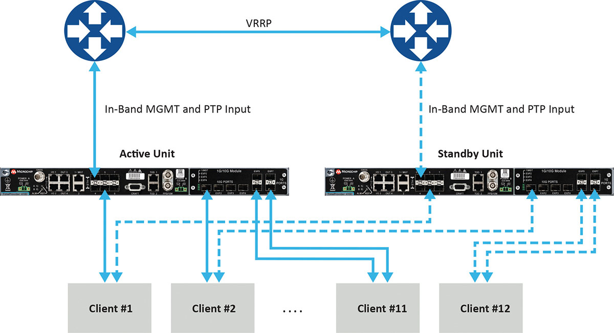
Figure 1 depicts a commonly deployed redundancy use case with two aggregation routers using virtual router redundancy protocol (VRRP).
Figure 1. Example of redundancy connectivity between the active and standby units. (Image: Microchip)
Software redundancy is a dual-unit scheme based on two reasonably priced devices, one active and the other on standby. It is more cost-effective for two reasons. First, it does not involve a costly device design with expensive hardware modules. Second, each unit (passive and active) keeps all of its capabilities compared to a hardware redundant design, which involves duplication of modules in the device, thus reducing the existing possible capabilities to host the redundant module.
Software redundancy provides total redundancy of the whole device because the active and standby units are the same. One hundred percent of the capabilities are redundant, including oscillator, GNSS receiver, ports and input/outputs. A hardware module is only redundant for its own features, not the rest of the unit.
Leveraging Resiliency
Resiliency at the architecture level is key to engineering the network so grandmasters in the deployment can be connected to each other. Some grandmasters are connected to GNSS as their source of time and frequency. It is key to connect these systems to other 1588 grandmasters to enable assisted partial time support (APTS) and to leverage key innovation such as automatic asymmetry correction (AAC).
AAC is a key (patented) differentiator in a resilient design that enables calibration of the different paths a PTP flow may use to/from upstream grandmasters, thus allowing for a backup in case GNSS fails at the location of a grandmaster. A backup path to an upstream grandmaster can guarantee uninterrupted and precise time and phase operation. This architecture makes sure that GNSS can be backed up by IEEE 1588 Precision Time Protocol (PTP) when GNSS is interrupted, with the best path being utilized.
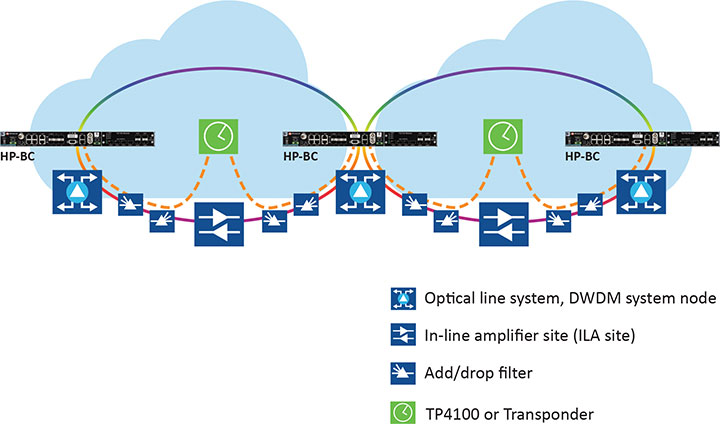
The alternative architecture choice is virtual PRTC (vPRTC), which enables operators to leverage redundancy and resiliency via a chain of high-performance boundary clocks using PTP over long distances for high accuracy, typically over optical networks. This architecture reduces reliance on GNSS and uses PTP as its primary source of time and phase.
Figure 2 depicts an optical network deployment with a dedicated optical timing channel (OTC) for high-accuracy distribution of phase over long distances.
Figure 2. Optical network deployment with OTC. (Image: Microchip)
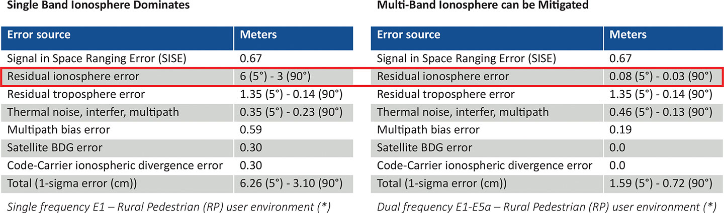
Resiliency at the device level starts with the right choice of an oscillator, from OCXO to atomic clock (Rubidium) — and is dependent on the location, use case and respective requirements for timekeeping holdover performance. Also, the choice of GNSS receiver is key. Some typically support a single frequency, yet ionospheric phenomenon can create significant time delays during cyclical events such as solar storms. To mitigate such delays, a multi-band GNSS receiver is required.
Figure 3 depicts a comparison between single-band and multi-band time delays due to ionospheric effects and shows how multiband clearly mitigates the time error as highlighted in red.
GNSS satellites transmit time information in several frequency bands. The delay difference between signals at different frequencies provides information about ionospheric impact on the absolute delay. This enables multi-band GNSS receivers to compensate for delay variations of radio signals transmitted from the satellite to the receiver. Embedding a multi-band receiver mitigates these time delays, which is critical for applications requiring Primary Reference Time Clock class B (PRTC-B),40 ns, as well as enhanced PRTC (ePRTC) 30 ns.
These device design choices are equally important. The GNSS receiver can be embedded inside the unit on the main board, or it can be offered as a hardware module, often at an additional cost, and may impact and replace an existing module that needs to be ripped and replaced. It may be preferable to have the unit enabled with a multi-band receiver and have the multi-band capability turned on via a license as opposed to offering a multiband option on a hardware module, as this becomes a tradeoff with other important capabilities.
Evaluating Security
Security is of utmost importance. Authentication and authorization via standard mechanisms such as Terminal Access Controller Access Control System + (TACACS+) and Remote Authentication Dial-In User Service (RADIUS) provide the benefit of a standard security framework. In addition, two-factor authentication (2FA) is an extra layer of protection used to ensure the security of accounts beyond just a username and password.
Also, it is key to provide Secure Shell (SSH) extensions with various levels of security profiles to offer more granularity for the types of users and related access rights and limitations. Offering high-security profiles provides for the definition and enforcement of the most stringent access rules to the system. Scripting vulnerabilities and relevant Common Vulnerabilities and Exposures (CVE) need to be addressed to make sure all potential security holes are being reviewed and addressed.
Plus, evolving jamming and spoofing threats need to be part of the precise time security strategy and implementation via monitoring of signals and consistency checks and remediation. Automatic gain control (AGC) and other metrics can be leveraged to provide thresholds with interpretation of results, as well as mitigation actions when encountered.
Final Decision Making
To ensure continued performance, it is critical to make the right architecture choices. A thorough network engineering study should include the locations where grandmaster units need to be deployed and their performance and accuracy requirements. These steps will guide which types of precise time and synchronization devices need to be selected
In addition, network planners and synchronization engineers should pay careful attention to design choices such as fanless devices versus devices that require a fan, modular hardware redundancy versus software redundancy, and the related advantages in terms of cost and tradeoffs — as well as similar choices regarding embedded or modular GNSS.
These choices can lead critical infrastructure operators to deploy redundancy, resiliency and security at all layers.
For architecture choices and solutions, visit vPRTC..White papers on this topic and others are also available. Additional information on devices and redundancy software schema is here.
Eric Colard is head of Emerging Products, Frequency & Time Systems at Microchip. He leads the product line management for Microchip’s TimeProvider 4100 and Integrated GNSS Master solutions for the telecom, utility and other industries.
Microchip Technology has integrate its BlueSky technology signal-anomaly detection software into its SyncServer S600 Series network time server and instruments.
The SyncServer S600 Series now provides GPS jamming and spoofing detection and protection, in combination with local radio frequency (RF) data logging and analysis. The SyncServer S600 Series Stratum 1 instrument, along with the BlueSky technology’s intelligent jamming and spoofing detectors, continuously monitor local GPS constellation health and examine GPS and local RF signal integrity to assure validity.
If an anomaly is detected, the solution sends an alarm and, if necessary, the SyncServer instrument can be shifted to alternative time sources or an internal oscillator. This protects ongoing timing outputs while ensuring only minimal, predictable timing degradation to vital network and business operations in applications ranging from banking and stock trading to electric utilities and aerospace and defense.
The SyncServer BlueSky technology, which provides continuous detection and protection against GPS jamming and spoofing. includes a comprehensive suite of logging, charting and measuring tools to characterize local GPS satellite signals as well as local RF events over time.
This can help enable correlating, troubleshooting, identifying and correcting local anomalies, some of which may be related to consumer electronics, or nearby RF signal broadcasts. The solution is optionally available through the SyncServer v4.1 software release that provides a selection of features found in Microchip’s BlueSky GNSS Firewall solution for third-party GPS receivers and critical infrastructure.
In separate letters to the Office of Management and Budget (OMB) and new Secretary of Transportation Buttigieg, influential members of Congress have urged the Biden administration to take prompt action and establish a backup timing capability for GPS.
Danger and Benefits, Solution in Hand
On March 1, Republican representatives Sam Graves and Bob Gibbs wrote to the acting OMB director citing the dangers of not having a backup, and the benefits one would bring. Graves is the ranking member of the House Transportation and Infrastructure Committee.
Calling backup timing for GPS “important telecommunications infrastructure,” they said the capability is essential. Without a backup “… it is not a question of if our transportation, financial, and telecommunications infrastructure systems will fail, it is a question of when.”
After describing some of the threats to GPS, they observed that America will suffer from an outage more than many of its adversaries. Russia and China were cited as examples of nations that already have terrestrial backup systems for space-based PNT.
The letter to OMB also cited the benefits to safety, autonomous and intelligent transportation systems, along with “5G & Future Telecommunications.” GPS interference has led to a near crash of a commercial passenger aircraft, drone accidents, and allowed white-hat hackers to force cars off the road. The letter also referenced a report by the Alliance for Telecommunications Industry Solutions (ATIS) calling for a national timing solution to complement GPS. Such a solution would “…allow faster 5G implementation and enable it to reach more Americans.”
Graves and Gibbs also mentioned the Department of Transportation’s (DOT) January report to Congress on its GPS Backup Technology Demonstration. The report called for an architecture that included signals from space in the L band, terrestrial broadcasts in the Ultra High Frequency and Low Frequency spectra, and a fiber backbone to synchronize and feed precise time to terrestrial transmitters.
Studies and Broken Promises
By contrast, a letter signed by Democratic House members focused on decades of administration studies, a broken promise, and failure to follow the law.
Transportation and Infrastructure Committee Chair Peter Defazio, along with Representatives Garamendi and Carbajal, wrote to DOT Secretary Buttigieg on Feb. 25. The letter noted that the need for a GPS backup was first identified in a 2001 DOT report. Since then, “…there have been over 18 studies and recommendations by the Federal Government calling for a land-based, wireless nationwide backup system.” Also mentioned were comments in 2014 by DHS officials calling the nation’s over-dependence on GPS “a single point of failure” for critical infrastructure.
Congress was encouraged in 2015 when the Obama administration said it would establish an eLoran timing system and follow it with a broader approach to GPS vulnerability. “This well-reasoned approach gave Congress encouragement that this national security problem would finally be addressed.”
“However, in 2018, after no additional action was taken, Congress took responsibility to codify the commitments outlined in the 2015 letter, and on a nearly unanimous bipartisan basis in both Houses, passed the National Timing Resilience and Security Act (NTRSA) to implement the land-based timing back-up system.”
The letter also notes that Congress further nudged the administration on this issue in last year’s appropriations. The act for 2021 provided funding for six new DOT staff positions to support the project and directed the department to make the hires.
Timing and Positioning
Observers say that it is almost certain the capabilities implemented to satisfy the terrestrial timing requirement in NTRSA will also provide a positioning capability independent of GPS.
NTRSA requires DOT to “… incorporate the recommendations from any GPS back-up demonstration program” into the solution set. The combination of technologies recommended by the demonstration report will provide users one or more terrestrial services from which location can be derived.
Also, mobile devices must know their locations to use wireless timing signals. Location information independent of space-based signals is needed to provide these users resilient timing service.
BAE Systems has received a $247 million contract from the U.S. Space Force’s Space and Missile Systems Center to design and manufacture an advanced military GPS receiver and next-generation semiconductor.
The technology will provide positioning, navigation, and timing (PNT) capabilities to warfighters so they can execute missions in challenging electromagnetic environments.
The Military GPS User Equipment (MGUE) Increment 2 Miniature Serial Interface program will provide improved capabilities for size-constrained and power-constrained military GPS applications, including precision-guided munitions and battery-powered handheld devices.
The program will focus on the certification of an advanced application-specific integrated circuit (ASIC) and the development of an ultra-small, low-power GPS module.
Both products will work with the next-generation military M-code signal technology, which provides reliable GPS data with anti-jamming and anti-spoofing capabilities to protect against electronic warfare threats.
“This program enables us to further develop our core M-code technology to deliver high-performance, next-generation GPS capabilities,” said Greg Wild, director of Navigation and Sensor Systems at BAE Systems. “Our M-code receiver and next-gen ASIC will enable secure and reliable military GPS capabilities in a broader range of platforms.”
BAE Systems’ Precision Strike business has 45 years of military GPS experience and more than 1.5 million GPS devices on over 280 platforms around the world. The company is currently producing M-code GPS receivers in multiple form factors, including a low power, small form factor M-code solution.
Additional prototypes are in development for ground, weapons and airborne mission applications, and the company’s M-code GPS products are available to U.S. allies via foreign military sales.
Work on the program will be conducted at the company’s facility in Cedar Rapids, Iowa.
Feature image: An Airman with the 374th Security Forces Squadron uses a Defense Advanced GPS Receiver (DAGR) to track the team’s current during a 2018 field training exercise at Camp Fuji, Japan. (Photo: Senior Airman Matthew Gilmore/U.S. Air Force)
A roundup of recent products in the GNSS and inertial positioning industry from the February 2021 issue of GPS World magazine.
OEM
Development kit
Allows engineers to evaluate GNSS/INS module
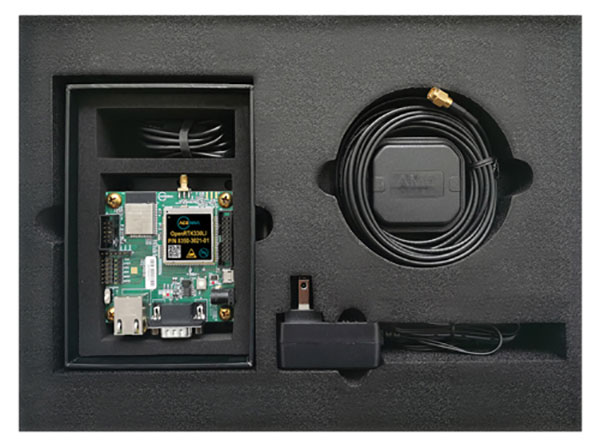
Photo: Aceinna
The Aceinna OpenRTK330LI EVK is a complete evaluation and development kit for the OpenRTK330LI GNSS/INS module. The kit accelerates development and reduces time to market of custom navigation and guidance systems fusing inertial measurements and multi-band RTK/GNSS positioning. It provides the essential hardware, firmware and development environment that engineers working on autonomous applications need to quickly start developing algorithms and solutions, allowing engineers to log and visualize positioning data with centimeter precision.
The OSA 5412 and 5422 are edge and access network synchronization devices with enhanced capabilities for next-generation applications such as 5G. The Oscilloquartz solutions address key challenges for a wide range of industries by bringing new levels of timing accuracy and resilience to edge networks. Both models provide in-service sync probing and assurance as well as innovative GNSS assurance capabilities. The devices also eight field-upgradeable, 10-gigabits-per-second ports, ensuring the scale and efficiency needed for next-generation smart grids, industrial internet of things (IoT) applications and 5G connectivity.
The AirgainConnect AC-HPUE 6-in-1 is a rugged outdoor mobile antenna with integrated modem, designed to meet the most demanding LTE connectivity needs of public safety and fleet vehicles. AC-HPUE provides two or three high-gain multi-band LTE antennas and one-band 14 LTE antenna powered by an HPUE LTE modem. The AC-HPUE supports an active GNSS element as well as two or three high-gain tri-band Wi-Fi antennas, including the new 6 GHz ISM band for Wi-Fi 6E (802.11ax), inside a single robust and compact housing. AC-HPUE attaches to the router WAN port via Ethernet data cable or directly to a laptop via USB cable. Wi-Fi and GNSS antennas connect to the router, meaning the router can be seamlessly used for Wi-Fi, location-based services, and managed using existing network management systems.
Amazon Monitron provides customers with an end-to-end machine monitoring solution comprised of sensors, gateway and machine learning service to detect abnormal equipment conditions that may require maintenance. Monitron is one of five new machine learning services that help industrial and manufacturing customers embed intelligence in their production processes to improve operational efficiency, quality control, security and workplace safety. The services combine sophisticated machine learning, sensor analysis and computer vision capabilities to address technical challenges faced by industrial customers. The other four services are Amazon Lookout for Equipment, the AWS Panorama Appliance, the AWS Panorama SDK and Amazon Lookout for Vision.
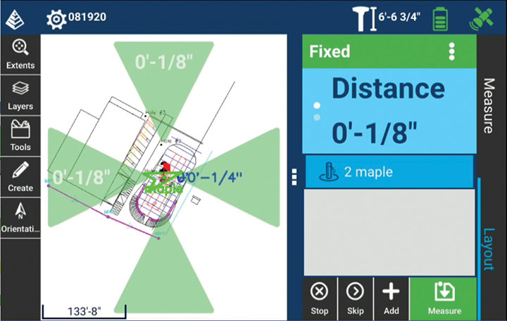
Carlson Layout allows fast, efficient layout capabilities for construction professionals using total stations or GPS receivers such as the Carlson CR+ series of robotic total stations and the Carlson BRx7 GNSS receiver. Included are the full Carlson driver library and a range of compatible hardware options. Features include an intuitive user experience, support for DXF and DWG files, integration with Google Drive and other cloud storage, compatibility with Carlson CRD and CRDB files, and the ability to check surface or fixed elevations without creating points. It also includes simple layout for points, lines and surfaces. Layout works with GPS real-time kinematic (RTK) systems and can receive RTK connections from a cellphone, internal modem, internal radio or external radio.
Surfer is a gridding, contouring and 3D surface-mapping package. The latest version offers a greater number of options for displaying scientific data. New display options enable users to more easily communicate the information extracted from their data. The Surfer package is used by professionals in oil and gas exploration, environmental consulting, mining, engineering and geospatial projects to easily visualize and interpret complex data sets. Surfer enables users to model data sets, apply an array of advanced analytics tools, and graphically communicate the results. Features include a new peaks and depressions layer type for mapping geohazards or drainage patterns in karst topographies.
Uinta’s data collection tools include detailed mapping with points, lines, areas and form-based notes for digital recordkeeping. Customization options allow organizations to create templates that better align with the type of data they are mapping and recording. Templates can be shared among users, and Juniper Systems has many templates for various industries and use cases. Users can export data to a file, print professional PDF map reports, and create optional cloud projects. Combined with a Mesa 3 Rugged Tablet running Windows 10 and a Geode Sub-meter GPS Receiver, Uinta offers a rugged, robust and powerful data collection solution. Industries using Uinta include utility mapping, government asset management and mapping, industrial assets, irrigation, and sectors within natural resources.
The FLY-R R2-150 has a top speed of 200 km/h (124 mph). Currently in functioning prototype form, the battery-powered R2-150 is designed for such tasks as fully autonomous surveillance, observation and reconnaissance. It has a wingspan of 1.5 meters (4.9 feet), a cruising speed of 115 km/h (71 mph), and can fly for up to two hours per charge while transmitting real-time video. It can automatically take off from a ship- or truck-mounted vacuum launcher and land in a recovery net. Another model, the jet-powered R2-HSTD, is expected to have a top speed of Mach 0.65 (803 km/h or 499 mph) and is intended to serve as a target drone for military exercises. FLY-R’s aircraft incorporate a rhomboidal wing design, which reduces wingspan by half and reduces aerodynamic drag.
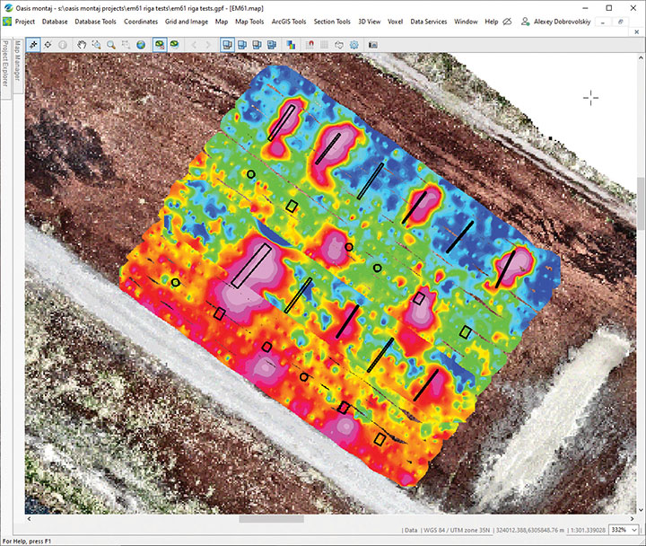
The drone-integrated metal detection system uses an airborne modification of the Geonics EM61-MK2 ground metal detector. The EM61 Lite airborne variant integrates with the UgCS SkyHub onboard computer and ground control station. Features include automatic data logging in geotagged form and automatic terrain following with radar altimeter. The use of UgCS SkyHub enables the drone to fly in true terrain following mode with the help of the radar altimeter and to log geotagged sensor data. An optional RTK/PPK GNSS receiver on the drone will geotag the data with centimeter-level precision. The integrated system has been extensively tested at SPH Engineering’s test range, and has shown excellent performance and repeatability for targets such as pipes (steel, stainless steel, reinforced concrete) and steel drums. Applications include unexploded ordnance (UXO) search, detection of underground infrastructure and archaeology.
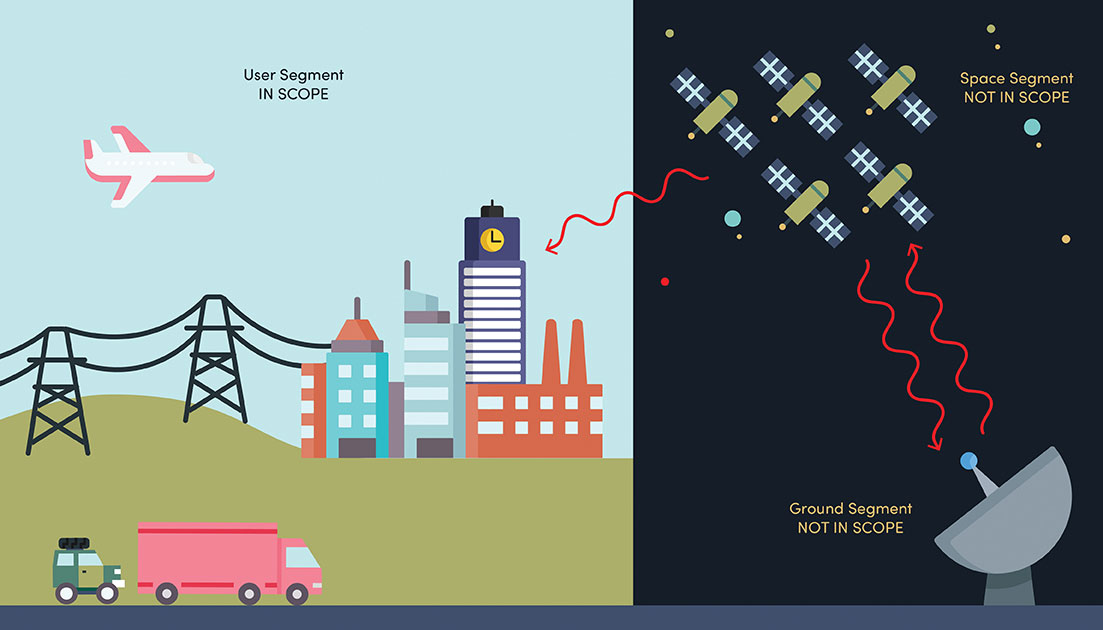
NIST’s new cybersecurity profile is designed to help mitigate risks to systems that use PNT data, including finance, transportation, energy and other critical infrastructure. While its scope does not include ground- or space-based PNT source signal generators and providers (such as satellites), the profile still covers a wide swath of technologies. (Image: B. Hayes/NIST)
The National Institute of Standards and Technology (NIST) has drafted guidelines for applying its Cybersecurity Framework to critical technologies such as GPS that use positioning, navigation and timing (PNT) data. Part of a larger NIST effort to safeguard systems that rely on PNT data, these cybersecurity guidelines accompany NIST efforts to provide and test a resilient timekeeping signal that is independent of GPS.
Formally titled the “Cybersecurity Profile for the Responsible Use of Positioning, Navigation and Timing (PNT) Services (NISTIR 8323),” the new guidelines are designed to help mitigate cybersecurity risks that endanger systems important to national and economic security, including those that underpin modern finance, transportation, energy and additional economic sectors.
The draft profile is part of NIST’s response to the Feb. 12, 2020, Executive Order on PNT. In early 2020, NIST sought public input regarding the general use of PNT data. The PNT profile will join the growing list of profiles created to help apply the NIST Cybersecurity Framework to particular economic sectors, such as manufacturing, the power grid and the maritime industry. The scope of the profile includes any system, network or other asset that uses PNT services, including systems that receive and rebroadcast PNT data.
While its scope does not include ground- or space-based source PNT signal generators and providers (such as satellites), the profile still covers a wide swath of technologies. Partly for this reason, NIST’s Jim McCarthy said that it is intended to be a foundational set of guidelines that PNT users can customize.
“The profile is meant to help a broad set of users address their cybersecurity needs,” said McCarthy, one of the draft’s authors. “Rather than focus on a single economic sector, we designed it to apply to all users of PNT. Agencies and companies can tailor it to their needs based on their particular cybersecurity risk and other sector-specific factors.”
As directed by the Executive Order, the profile can help organizations accomplish four tasks:
identify systems that use PNT data, and/or that propagate this data based on a source signal
identify PNT data sources, such as a GPS signal
detect disturbance to and manipulation of systems that use PNT services
manage the risks that come with responsible use of these PNT services
“Our premise is that there are organizations that may not realize they are using PNT data, or know how they are using it,” McCarthy said. “Part of our goal is to help them make these connections so they can protect their operations more effectively.”
The Executive Order also delegates to the Department of Commerce the critical task of providing a source of Coordinated Universal Time (UTC) that is independent of GPS. To this end, NIST also recently conducted initial tests of a special calibration service for companies, utilities or other organizations that wish to receive NIST’s version of the global time standard, UTC(NIST), through commercial fiber-optic cable.
The service aims to provide a time reference directly traceable to UTC(NIST) with an accuracy of 1 microsecond — good enough for telecom networks, the power grid and financial markets, and thereby boosting the resilience of accurate time distribution and the infrastructure sectors and subsectors that use timing services.
The initial link is a collaboration between NIST and OPNT, a commercial time-service provider based in Amsterdam, the Netherlands. While the work was led by researchers at NIST’s Boulder, Colorado, campus, the dedicated optical fiber connects the reference time scale at NIST headquarters in Gaithersburg, Maryland, to a facility in McLean, Virginia, that will ultimately serve as the hub for East Coast distribution of timing data.
OPNT has extended the initial fiber link to Atlanta, Georgia, about 800 kilometers from McLean. Preliminary data suggest that this link will be able to support the requirements of the Executive Order.