TomTom has extended its the multi-year partnership with AOL Inc. to power its core mapping services for MapQuest, a subsidiary of AOL.
In addition to providing access to TomTom’s extensive digital map database, across all digital platforms including MapQuest.com and its iOS and Android apps, and MapQuest for Business API solutions, the new deal now includes TomTom’s leading traffic solution.
“Every day, millions of people depend on MapQuest for maps, driving directions and location information to make their lives easier and thousands of business depend on MapQuest’s suite of geospatial solutions to meet their needs,” said Brian McMahon, senior vice president and general manager at MapQuest. “We truly value the partnership with TomTom, and we look forward to continuing to build upon and evolve our product suite with TomTom data. By expanding our agreement with TomTom, we are continuing our commitment to provide MapQuest users and business customers with the most innovative products and solutions.”
“We are delighted to enhance our partnership with MapQuest,” commented Anders Truelsen, Managing Director of Licensing for TomTom. “Integrating TomTom’s mapping and traffic data into MapQuest products ensures millions of people can make better and more informed decisions about every journey.”
TomTom has entered a technology collaboration with sensewhere, a provider of indoor positioning technology. According to the companies, the collaboration will enable the two companies to conquer GPS black spots and bring location-based services indoors.
TomTom Indoor delivers accurate customized indoor maps of public and private venues for site operators and other partners that enable increased efficiency, cost savings and an improved customer experience.
sensewhere has developed a proprietary and patented positioning solution for mobile devices. The combination of TomTom’s maps — both indoor and traditional navigation maps — and sensewhere’s accurate indoor positioning will enable a seamless navigation experience indoors and outdoors.
sensewhere algorithms enable location for indoor locations such as shopping malls, using sensors such as Wi-Fi and Bluetooth.
“Access to indoor positioning technology, coupled with highly accurate indoor maps, means that guidance can be integrated into the day-to-day operations of a wide variety of venues, including enterprise facilities, shopping malls, airports, hospitals and more,” said Pieter Gillegot-Vergauwen, vice president, Maps Product Management, TomTom. “With the explosion of the Internet of Things, we believe that by partnering with sensewhere our customers will not only be able to gain efficiencies, but will also deliver a better experience to their own customers.”
“We are excited to help TomTom extend its navigation prowess indoors with this technology collaboration,” said Rob Palfreyman, CEO of sensewhere. “We believe this integration is a perfect fit for enterprises that need to combine location intelligence, resource planning and efficient execution.”
Where’s Waldo? sensewhere uses pinpoint people to illustrate how its system works in a home page video.
TomTom has expanded coverage of its High Definition (HD) Map and RoadDNA products to 17 new states across the U.S., the company announced at TU-Automotive Detroit, which is being held June 8-9 in Novi, Michigan.
“With over 122,000 kilometres (75,800 miles) of HD Map coverage globally, we’re equipping our automotive customers with the data needed to continue to push autonomous driving forward,” said Willem Strijbosch, head of autonomous driving at TomTom. “The importance of having a map in the vehicle for autonomous driving is now widely accepted; TomTom has responded to this need with an unprecedented ability to provide HD Maps today, while others are still in the R&D stage.”
TomTom’s HD Map and RoadDNA are now available for interstates in Connecticut, Delaware, District of Columbia, Georgia, Idaho, Kansas, Louisiana, New Hampshire, New Mexico, North Carolina, Ohio, Pennsylvania, Rhode Island, South Dakota, Tennessee, Texas, and Vermont; interstates and highways in California, Michigan, and Nevada;
and the Autobahn network in Germany.
TomTom HD Map and RoadDNA are two highly accurate digital map products aiding automated vehicles to precisely locate themselves on the road and plan maneuvers. The technologies are being rolled out in strategic geographies and are the subject of key partnerships with other automotive suppliers.
The company also unveiled its Localisation Demonstrator, a new demonstration device that leverages its HD Map and RoadDNA technology to provide lane-level localization of a vehicle. The device, utilizing sensors, combines TomTom autonomous driving content with TomTom correlation software for precision of the data, and the ability to perform real-time lane positioning.
“We believe that this demo enables our customers to truly experience the powerful nature of our autonomous driving products,” Strijboschsaid. “This demo not only illustrates TomTom’s product innovation but also enables us to elevate the level of engagement with our automotive partners.”
The company is showcasing its autonomous driving products at booth C116 at TU-Automotive.
Uber has made big moves implementing location technology by signing a deal with TomTom, buying Microsoft’s mapping technology, and outright purchasing deCarta this year. The company is working with Carnegie Mellon University in Pittsburg to develop autonomous vehicle technology. In other location news, distinct technology is cropping up in the indoor location market to make widespread implementation possible.
Kevin Dennehy
Uber is becoming a big player in the location industry with its announcement this month that it will use TomTom’s maps and traffic data for its ride-hailing service. The deal’s financial terms were not disclosed.
While Uber unsuccessfully made a $3 billion bid for Nokia’s mapping business, it also acquired Microsoft’s mapping technology and the key personnel that came with it. The San Francisco-based company, currently operating in 300 cities worldwide, also acquired veteran location industry deCarta earlier this year.
The mapping data will be key in Uber’s strategy to be a major force in autonomous vehicle development. To research driverless cars, Uber has leased a 53,000-square-foot facility in Pittsburgh.
The question is, what market segment will be first for major autonomous vehicle rollout? At least one executive believes such technology companies as Uber have the advantage. “Because the continued success of [Uber’s] business depends on it, and they have the money to spend on it to gain a competitive advantage,” explained Scott Frank, Airbiquity vice president of marketing. “If ride share companies can reduce the variability and expense of physical drivers, they can reduce the cost of their services — even while improving their margins, and compete more effectively for market share versus private ride services, like taxis/limousines and public transportation, which is more limiting in terms of availability and comfort.”
Frank says his company sees the market differently than others when it comes to autonomous vehicle development and rollout. “Google has been clear since the beginning about their automotive end goal, which takes a very long-range view — produce fully autonomous vehicles connected to public infrastructure with everything connected by Android and enabled by Google computing, data management, service delivery and advertising capability,” he said.
Apple and Tesla’s ambitions are more in close and short-term, in that they want to produce electric vehicles that are better than what the traditional automakers are able to churn out, Frank said.
“Uber is a recent entry into the fray, so it’s a bit premature to put them in the ‘build a vehicle platform’ class, although it’s becoming evident that they are very interested in developing underlying technologies that autonomous cars will certainly rely on,” he said. “In the last couple of months we’ve seen public statements from large traditional automakers referencing their autonomous vehicle ambitions, so they are definitely going to step up and not simply concede the autonomous opportunity to Google — or any another automotive industry newcomers.”
Frank believes there are distinct areas in the United States where autonomous vehicle rollouts make sense. “[Companies are looking at] transportation pain points that autonomous will solve like urban traffic and lack of easy and affordable parking, public transportation infrastructure that can more easily accommodate the necessary changes to integrate and support autonomous, and metro sizes that aren’t so large that it would impossible and/or too costly to get anything done,” he said. “So cities like Portland, Minneapolis, Austin, Raleigh and [such areas as] Silicon Valley come to mind, to name just a few.”
Either way, autonomous vehicles will present huge societal and business changes and such questions as will the public trust the new technology and get them where they need to go, safely and reliably, Frank said. “As with all new technologies there will be an adoption curve at play here with early adaptors taking the lead ahead of the mainstream,” he said. “We saw the same thing with horseless carriages, by the way. People placed more trust in their horses before they began to understand and allow themselves to realize the benefits of motorized transportation.”
In other autonomous vehicle news, Ford said last week it was ramping up its driverless car efforts by being the first automaker to test its self-driving cars at Mcity, a 32-acre prototype town with private roads in Ann Arbor, Mich.
Indoor Location Market Finds Low-Cost Technology
Recent advancements in chip-based indoor location position technology are allowing developers to find a low-cost way to get the capability into multiple devices, said Bruce Krulwich, Grizzly Analytics founder.
“The most exciting aspect of recent advances in chip-based indoor location positioning technologies is that indoor positioning is being added to the next generations of chipsets already being used in today’s smartphones,” said Krulwich, who recently released a new study, Chip-Based Indoor Location Technologies, which profiles GPS, Wi-Fi and sensor processing chips. “This means that the chips that device makers already include in their designs will soon include indoor location capabilities.”
The biggest advantage of chip-based approaches is that they can integrate data from GPS, Wi-Fi and MEMS motion sensors at a very low level, using data direct from the chips, without requiring work by the CPU to enable more efficient and continuous location positioning, Krulwich said.
“While there are many approaches being taken by the chip makers, the one that I’m most excited about is the combination of motion sensing with GPS. In this approach, the same chips that process GPS signals also use data from MEMS sensors, such as accelerometers, gyroscopes and magnetometers, to track locations when GPS signals are unavailable,” he said. “Motion-sensing approaches don’t work forever, since errors in the sensors accumulate over time, but should be able to give reasonable location estimates for 10-15 minutes after a person walks inside. This should be long enough to be a very valuable source of location positioning in between GPS or Wi-Fi signals.
Krulwich said this positioning approach can work anywhere, without Wi-Fi hotspots, BLE beacons or even maps of the site. “This is the closest to ubiquitous location positioning that I’ve seen,” he said.
Krulwich believes the new chip technology will allow the first large-scale incorporation of location technologies into electronic devices, appliances, wearables, Internet of Things (IoT) and others. “A cool example is a camera that tracks an athlete’s location automatically as they run around the basketball court.”
In other location news:
A new agenda is out for Driverless, which will be March 22-23, 2016, at the Crowne Plaza Hotel, San Francisco Airport. The autonomous vehicle conference will feature more than 30 speakers and 15 exhibitors. Go to www.driverlessmarket.com for more information.
TomTom has signed a global, multi-year agreement to provide maps and traffic data for the Uber driver app.
TomTom’s advanced map-making technology, combined with its traffic information, will ensure Uber has a seamless navigation experience, accurate arrival times and efficient journeys in more than 300 cities around the world, according to a TomTom news release.
“We are excited to provide Uber with our best-in-class location data,” said Charles Cautley, managing director, Maps and Licensing at TomTom. “TomTom is a truly independent map provider with the platform for the future. With this platform, TomTom is the trusted partner for innovative and future proof location technology for the global automotive and consumer technology industry.”
“We look forward to working with TomTom, a leader in the mapping and navigation space,” said Matt Wyndowe, head of Product Partnerships at Uber. “Their mapping and traffic data will help ensure we continue to provide a great experience for drivers everywhere.”
TomTom’s map and traffic information have been chosen by the University of Minnesota’s Accessibility Observatory as part of a new national accessibility data set.
TomTom will provide map and historical speed data to help analyze accessibility to jobs for driving and transit for metropolitan areas across the United States. For transit data, the Observatory is relying on open, public sources using a method developed at the University with support from the Center for Transportation Studies.
Study partners will be able to use this data for policy development, local transportation system evaluation, performance management, planning and research efforts. Each partner will have direct digital access to the accessibility datasets for the jurisdictions of all partners and will receive detailed reports of local accessibility trends and patterns. The Minnesota Department of Transportation is the lead agency and coordinator for the national pooled-fund study. Other participating agencies are the Federal Highway Administration (FHWA) and the DOTs of California, Florida, Iowa, North Carolina, Virginia and Wisconsin.
“Today’s transportation user wants more than mobility — they want accessibility and they want MnDOT to invest in the appropriate solution, at the right place, at the right time, and at the appropriate cost,” said Tim Henkel, division director of modal planning and program management at MnDOT. “The Accessibility Observatory offers solutions to these decision-making challenges.”
The Transportation Pooled Fund Program, part of the National Cooperative Highway Research Program, allows state DOTs, FHWA program offices, and other organizations to combine resources and achieve common research goals. Additional partners are welcome to join the study.
“We’re excited that the UMN Accessibility Observatory has selected TomTom to help provide geospatial and transportation information for this project,” said Ralf-Peter Schäfer, head of traffic at TomTom. “We are confident that the TomTom map and traffic content will contribute to a better understanding of job accessibility nationwide.”
TomTom has added navigable maps for 13 new countries. TomTom’s global map database now covers more than 45.6 million kilometers and 4.3 billion people worldwide, and features full navigable coverage for 134 countries.
“The addition of nearly 3 million kilometers of roads in one year demonstrates TomTom’s commitment to geo-expansion,” said Charles Cautley, managing director of TomTom Maps. “We rely on intelligent mapmaking and our transactional mapmaking engine to continuously deliver map updates around the globe, increasing coverage and improving map features for all business customers.”
Global map enhancements include:
The launch of navigable, turn-by-turn maps for Macedonia, Bosnia & Herzegovina, Peru, Guatemala, Nicarágua, Panamá, Costa Rica, Honduras, El Salvador, Iraq, Ghana, Rwanda and Burundi.
Introduction of Address Points to enable better geocoding and navigation in Austria, Luxemburg, Turkey and South Africa; significant growth in Address Point coverage for South East Asia reaching 3.6 million.
Significant Points of Interest growth in Mexico, bringing count to more than 3 million.
Launch of 3D Map for Singapore and the debut of visualization products for the Middle East, with an Advanced City Model of Riyadh and 2D City Maps for 15 cities.
After months of negotiation, Nokia will sell its HERE Maps division to a consortium of German automakers — BMW, Daimler and Volkswagen — for $2.71 billion, according to the TU Automotive website.
Under the agreement, HERE Maps would turn into an open platform that all car manufacturers can use for navigation and mapping inside vehicles, giving automakers independence from companies such as Google for maps and navigation at a time when the technology moves toward the connected and self-driving car, which rely on navigation technology.
The three German car makers plan to offer the platform to Fiat Chrysler, Renault, Peugeot, Ford, Toyota and General Motors, allowing them to use the mapping service for free without licensing issues.
Nokia is selling the entire unit of HERE, meaning the car consortium will likely continue hiring developers to work on the platform. Companies like Chinese search giant Baidu and Facebook use HERE Maps to power its own mapping services. It remains to be seen how the new deal will affect those services.
“Only with high-precision maps will automated driving on freeways be possible from 2020,” said Bosch board member Dirk Hoheisel. TomTom says it plans to have new high-precision maps for automated driving for all freeways and freeway-like roads in Germany by the end of 2015.
TomTom is making available Highly Automated Driving (HAD) map content in the metro Detroit area, where U.S. automakers are headquartered. Car makers and HAD-related companies can now use TomTom’s high-definition maps for precise vehicle positioning, enabling future self-driving cars to see beyond their sensors.
The HAD map, covering the stretch of road network between Farmington Hills and Ann Arbor, including I-696, 96, and 275, US-23 and M-14, will be available in June. TomTom discussed the HAD map in a session at TU-Automotive Detroit trade show, held June 3-4.
“By making high-definition map content readily available, we can make HAD a reality faster, enabling further innovation in Detroit, the heart of the North American automotive industry,” said Alain De Taeye, member of the TomTom Management Board. “Intense demand for high-definition maps is fueled by automated driving as a new growth driver. As an independent supplier with one of the world’s most sophisticated mapping platform, we are in a unique position to provide highly precise map content for all members of the HAD ecosystem.”
For the Consumer Electronics Show (CES) 2015 in January, the Audi A7 piloted driving concept car dubbed Jack used TomTom HAD prototype maps to complete a long-distance test drive, over 560 miles from San Francisco to Las Vegas.
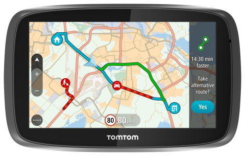
TomTom is introducing Lifetime World Maps and Lifetime Speed Cameras to drivers with the launch of four new TomTom navigation devices.
TomTom is introducing Lifetime World Maps and Lifetime Speed Cameras to drivers with the launch of new TomTom navigation devices. Lifetime World Maps allow people to drive with maps from around the world at no extra cost, for the lifetime of their TomTom GO device2. Lifetime Speed Cameras let drivers know the locations of all speed cameras — both fixed and mobile, also for the lifetime of the device.
The TomTom GO 510, 610, 5100 and 6100 feature a fully interactive screen to pinch, zoom and swipe — as well as a rich user interface, simplified user interaction, 3D Maps and a Click & Go mount. Drivers can also choose between a 5-inch or a 6-inch screen size, TomTom said. The new TomTom GO devices also include “Drive Home” and “Drive to Work” buttons in the main menu, for faster, simpler navigation.
TomTom GO devices combine real-time traffic information with routing technology, to always offer drivers the fastest route available. TomTom Traffic covers all mapped roads and combines data from millions of data sources, from all over the world, to deliver traffic information so accurate that, with each new update, it can pinpoint the start and end of a traffic jam, precisely, down to 10 meters.
“With the addition of Lifetime World Maps and Lifetime Speed Cameras to our new TomTom GO devices, we’re offering the most comprehensive package to drivers that we’ve ever launched,” said Corinne Vigreux, co-founder and managing director, TomTom Consumer. “Our aim is to help you avoid the jams, getting to your destination faster, wherever in the world you might be.”
Lifetime TomTom Traffic is available via a smartphone connection on the TomTom GO 510 and 610. The TomTom GO 5100 and 6100 offer Lifetime TomTom Traffic via a built-in SIM with unlimited data and roaming at no extra cost.
The new TomTom navigation devices are compatible with TomTom MyDrive4. For the first time, drivers can use their smartphone, tablet or PC to review real-time traffic information, plan routes, and send destinations to their TomTom GO, before they get in the car. Previously launched TomTom GO devices5 are also compatible with MyDrive though a simple software update. Find out more about TomTom MyDrive here.
The new TomTom GO devices are now available online and in-store from €199.95.
TomTom is partnering with Mozilla and Telefónica to bring its Maps Online and Nav Online apps to HTML5-powered Firefox OS smartphone devices.
“We’re thrilled to offer Firefox OS users TomTom’s Maps Online and Nav Online apps in the Firefox Marketplace,” said Bertrand Neveux, director of Marketplace and Ecosystem at Mozilla. “Our priority is to empower users with a mobile experience that makes their lives richer and more efficient, and great content like TomTom’s ensures that.”
“Telefónica has now launched Firefox OS devices in 14 markets and is pleased to see high-quality maps and navigation solutions from TomTom that enhance these devices for our consumers in Latin America and Europe,” said Simon Callan, director Business Development at Telefónica.
“TomTom is excited to be embracing the openness of HTML5 to bring high quality maps and turn-by-turn navigation to the ecosystem,” said Charles Cautley, managing director of TomTom Licensing. “By partnering with Mozilla and Telefónica, we’re opening new markets and opportunities for smartphone users globally.”
TomTom Maps Online offers accurate and up-to-date maps, as well as Address and Point of Interest search capabilities with routing instructions, enabling Mozilla customers to quickly and easily find their favorite places, TomTom said.
With TomTom Nav Online, Telefónica’s Firefox OS customers can extend the mapping experience to full voice-guided turn-by-turn navigation.