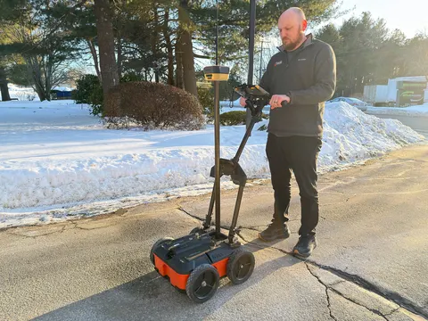
Topcon Positioning Systems and Geophysical Survey Systems, Inc. (GSSI) are collaborating to pair GSSI’s advanced ground penetrating radar systems with Topcon’s GNSS solutions and mass data workflow software. The new integrated solution will support applications across infrastructure and construction projects.
“GSSI is a long-standing industry leader in ground penetrating radar (GPR) systems, and we are excited to work with them on providing industry professionals with an advanced, integrated solution,” said Ron Oberlander, head of the Topcon Geomatics Platform. “By combining GSSI’s GPR technology with Topcon’s HiPer XR GNSS receiver, Topnet Live correction services, and Collage Web mass-data workflow software, we are bridging subsurface detection and spatial context from field to analysis.”
“Collaborating with Topcon allows us to unify GPR data and GNSS data to deliver visual, decision-ready insights, providing a more complete picture of the world above and below the surface,” said Chris Green, chief executive officer of GSSI. “Together, GSSI and Topcon are helping customers plan smarter, validate faster, and deliver higher quality outcomes with fewer surprises.”
The new solution will be showcased in both the Topcon Positioning Systems booth and the GSSI booth at CONEXPO-CON/AGG, taking place March 3-7 in Las Vegas.
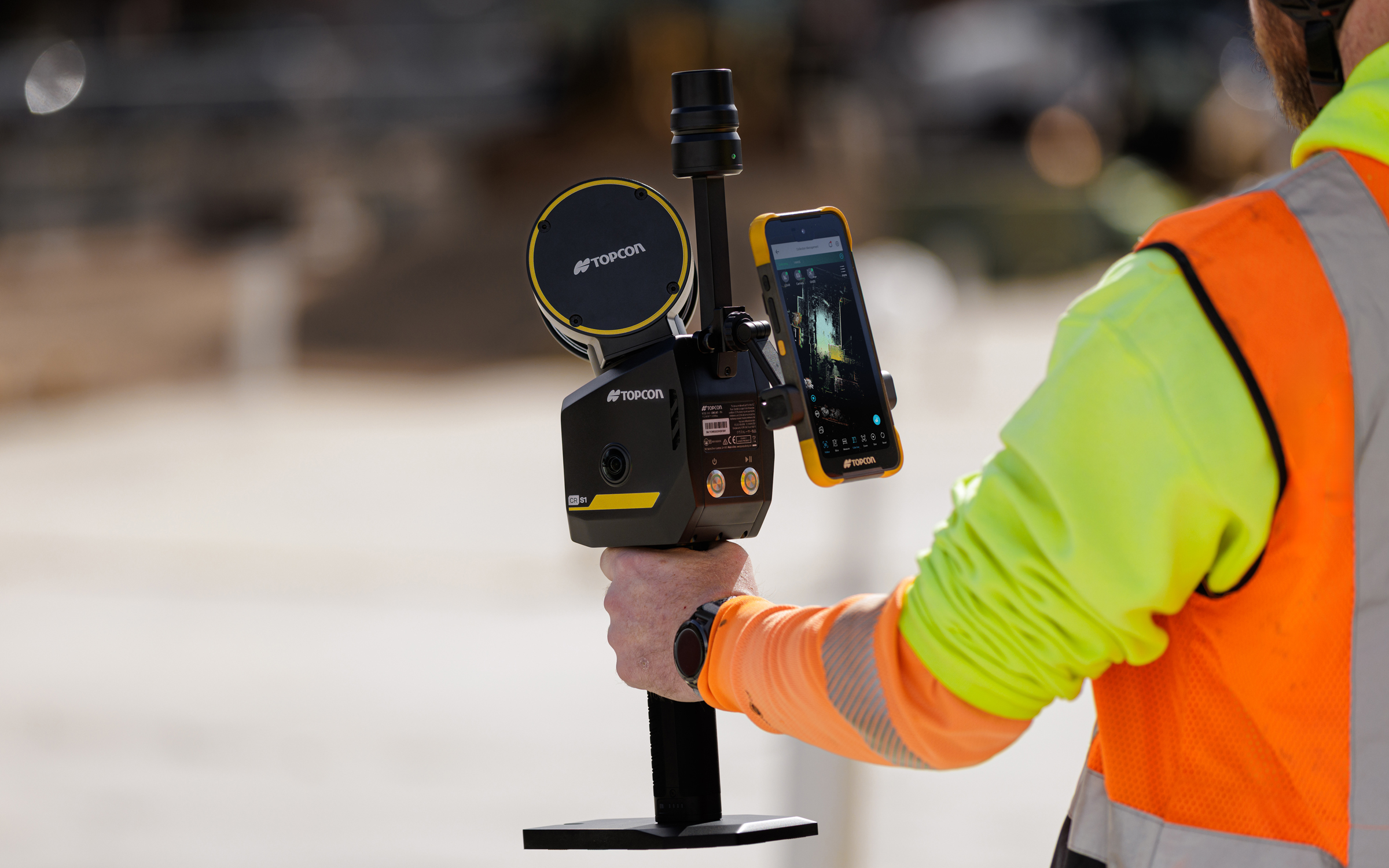
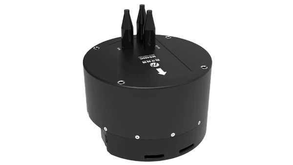
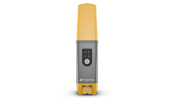
Topcon Positioning Systems has introduced the CR-S1, a handheld scanning system that combines ldar, panoramic cameras, visual SLAM cameras, and a GNSS antenna in a single device.
The CR-S1 expands the company’s Capture Reality portfolio as a higher‑performance option alongside the CR‑S2. It offers increased point‑cloud density, extended scanning range, and upgraded panoramic imaging.
The CR-S1 uses Topcon’s Collage mass-data software ecosystem central to a connected workflow.
For added positioning accuracy, the CR‑S1 can be connected to the Topnet Live RTK GNSS corrections service.
The system is primarily intended for surveying and construction. It is also well-suited for applications such as land surveying, tunnel surveying and modeling, forestry analysis, mining operations, utility mapping, and powerline inspection.
“Customers are looking for flexibility and efficient workflows, and our scanning portfolio and software are designed to support these needs through simplified processes, open integrations and mixed‑fleet compatibility,” said Ron Oberlander, head of the Topcon Geomatics Platform. “With Collage serving as the central data hub supporting inputs from multiple sensors, users can obtain accurate, detailed information for decision‑making.”
Software support includes MAGNET Flow for Android and iOS devices, MAGNET Bridge for SLAM data desktop processing, and Collage Web.
Topcon Collage Web is a cloud‑based platform for fast visualization, exploration, and sharing of 3D point‑cloud data directly in a web browser. It enables users to easily view and inspect datasets while supporting efficient collaboration across projects. Through the Collage Cloud Connector desktop application, projects are seamlessly synchronized with Collage Web, allowing smooth integration with Autodesk and ClearEdge3D software. This workflow supports mixed fleets and diverse industry systems, ensuring efficient data exchange and consistent project access across desktop and cloud environments.
Mounting options include backpack and front‑pack configurations for hands-free, load-bearing scanning while walking, as well as rover–pole operation. An adapter for mounting the CR-S1 on a vehicle for mobile mapping is also available.
The CR‑S1 is being showcased at Geo Week 2026, Feb. 16–18, in Denver, Colorado. It will be available through the Topcon dealer network with training and support.
“Topcon provides high-precision GNSS positioning technologies for geomatics, construction and agriculture applications worldwide,” explained Ron Oberlander, head of the Topcon Geomatics Platform. “Working with companies such as Fixposition — specialists in visual RTK (real-time kinematic) and visual-aided positioning — helps create added value for our customers.
According to Topcon, its customers are increasingly working in environments where satellite connection can be challenging, such as dense urban environments, and need consistent, reliable positioning to maintain productivity. Fixposition offers technology that augments satellite positioning, beneficial for users even while working inside structures and in indoor-outdoor transitions, without disrupting workflows by combining RTK GNSS with artificial intelligence to ensure position accuracy. “We see this AI-enabled technology as an innovative integration with our next-generation GNSS solutions,” Oberlander said.
“We’re proud to supply Fixposition’s xFusion, vision and multi-modality fusion positioning technology to support Topcon’s next-generation GNSS solutions,” said Zhenzhong Su, CEO and co-founder of Fixposition. “We look forward to bringing this new solution to market — helping surveying professionals across geomatics, construction and agriculture deliver faster results and get more done without compromising quality, even in GNSS-challenging environments.”
Fixposition has been integrating Topcon RTK corrections into its Vision-RTK sensors since 2023, when the companies announced an agreement providing Fixposition customers in North America and Europe with access to the Topnet Live RTK corrections service network.
Topcon Positioning Systems has signed a commercial agreement with Xona to secure early-adopter access to Pulsar, Xona’s low Earth orbit (LEO) satellite navigation constellation. This agreement positions Topcon among Xona’s first commercial customers preparing to integrate Pulsar into future high-precision positioning workflows.
“The letter of agreement reinforces Topcon’s long-standing commitment to innovation and customer-driven technology leadership,” said Ron Oberlander, head of the Topcon Geomatics Platform. “It lays the groundwork for a new era of high-precision performance possibilities as LEO satellites come online. By proactively adopting next-generation navigation infrastructure, we strengthen our commitment to provide reliable, resilient, and future-proof solutions for our customers.”
“Topcon understands where accuracy, continuity and confidence matter most for operators in the field,” said Bryan Chan, co-founder and VP of Strategy at Xona. “By adding a modern navigation layer into Topcon’s offerings, Pulsar will strengthen signal performance and resiliency in even the most challenging environments, ensuring Topcon customers can operate with greater confidence wherever their work takes them.”
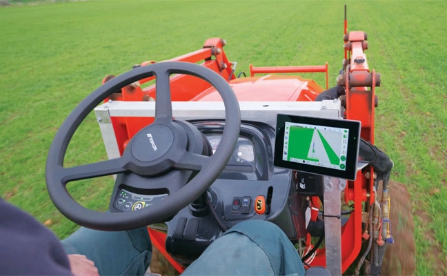
Allows upgrades of older machinery for smaller farms
Topcon’s has created a Value Line Steering solution for farmers using mid-range tractors on small- to medium-sized farms. It makes autosteering technology — typically used on larger machinery — accessible to a broader range of farmers. Farmers with older or smaller machinery, or small specialty farms, can boost the value of their machinery with the autosteering technology. The integrated system is designed to work across a wide range of applications, machinery and brands. It includes compliance with ISOBUS-UT to offer universal compatibility and ease of use. The package includes a GNSS receiver, electric steering wheel controller, touchscreen console and Horizon Lite software, compatible with front-wheel-steer tractors. Farmers can add local, satellite or RTK correction services such as Topcon’s Topnet Live for enhanced precision.
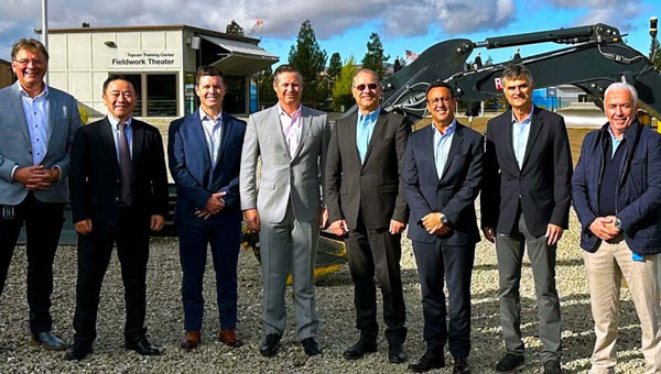
Topcon Positioning Systems and Amberg Technologies are entering into a collaboration agreement and launching fully integrated solutions for rail and tunnel applications. The interoperability of hardware and software platforms is designed to allow professionals to seamlessly combine technologies from both companies to enhance workflow efficiency and accuracy.
The announcement was made at Intergeo 2025, held Oct. 7-9, in Frankfurt, Germany.
At the show, Topcon also announced an expansion of its geomatics portfolio, featuring advancements in mass data software solutions central to a connected workflow ecosystem. The producs follow the announcement of the dedicated business structure focused on delivering high-precision technology, software, and services for geomatics.
The agreement with Amberg Technologies comes at a time when increased urbanization is driving demand for new underground infrastructure and placing demands on aging and existing infrastructure. Digitalization and automation can help contractors and civil engineering firms address these critical industry challenges, as well as labor shortages, tight project schedules, and increasingly complex design requirements.
Key capabilities resulting from this collaboration include the ability to utilize Topcon’s advanced positioning technology directly with Amberg’s rail and tunnel hardware and software platforms. This integration streamlines tasks such as track alignment, tunnel profiling, and volumetric analysis. The integrations address the need for technology systems that reduce data translation gaps between different hardware and software platforms, eliminating potential errors that can occur when transferring data between systems.
Geomatics products and services
Foundational tools for Topcon’s connected workflow are Collage and ClearEdge software, which allow for data, feature extraction, and the seamless delivery of results into GIS, BIM or CAD environments. Topcon Collage, available in Site, Office and Web versions, serves as a central data hub, enhancing data sharing among all project stakeholders in both the field and office. Topcon is also introducing the Collage Cloud Connector for improved connectivity with Autodesk platforms and ClearEdge solutions such as EdgeWise or Verity.
Featured hardware and software include:
CR-H1 handheld scanner: The CR-H1 handheld mapping solution utilizes iPhone Pro devices with integrated LiDAR that collects georeferenced images and employs photogrammetry to create detailed, full-color 3D point clouds. The iPhone connects to the Topcon HiPer CR receiver, enabling centimeter accuracy with RTK corrections from the Topnet Live GNSS corrections service. The receiver and iPhone are both mounted on a specialized handle, so users can easily capture point clouds while walking throughout the job site. The devices needed can quite simply be held in one hand for maximum mobility in the field.
CR-M1 scanner and new Onami software: The CR-M1 is an indoor/outdoor mapping system that can be utilized on a backpack or on a survey pole. The CR-M1 is ideal for urban and construction mapping, multi-floor buildings, real estate, underground mapping, mines and tunnels, stockpiles, and forestry environments. Publishing and sharing the CR-M1 data with Collage Web allows the user fast, web‑based visualization and manipulation of their 3D point clouds and meshes.
CR-P1 multi-functional 3D terrestrial laser scanner: The CR-P1 provides real-time, georeferenced point cloud generation on-site, equipping the user with actionable data that can be used for various applications. Enhancements to the Topcon Collage Site software solution provide new mass data workflow capabilities designed to allow for the real-time acquisition and processing of data more accurately, efficiently, and quickly to provide the user with greater productivity.
CR-S2 handheld scanner with Magnet Flow and Bridge software: The CR-S2 is a handheld scanning system that uses multiple localization fusion-SLAM to perform mapping projects in challenging environments. It is designed to work in construction and infrastructure applications as well as open, featureless environments such as beaches, coastlines, farmland, and airports. In open environments, the RTK connection to the Topnet Live network ensures position quality. Publishing and sharing the CR-S2 data into Collage Web allows the user fast, web-based 3D point cloud and mesh visualization with easy-to-use measurement and annotation tools.
LN-1000i Layout Navigator withTopcon Digital Layout software: The LN-1000i is an addition to the Layout Navigator series that includes new features, including reflectorless measurement capabilities, green laser beam pointer and an integrated camera for live view, camera control and enhanced prism lock. When combined with the new Topcon Digital Layout 2.0 software, this instrument is designed to set new standards in building construction.
Expanded Hybrid Positioning capabilities with Topcon software updates for Field – Office – Tools – Enterprise: Allows for better cooperation switching between GT robotic total stations and the HiPer XR GNSS receiver as an optical and GNSS hybrid solution. The new version 10 Topcon Field software enables the user to use the tilt of the IMU when measuring to the prism in Hybrid Positioning mode.
Collage Cloud Connector: New Windows app designed to simplify and automate the process of downloading and synchronizing project data from Collage Web to a local machine for use with Autodesk, ClearEdge3D software, or Collage Office.
Allows upgrades of older machinery for small farms
Topcon’s has created a Value Line Steering solution for farmers using mid-range tractors on small- to medium-sized farms. It makes autosteering technology — typically used on larger machinery — accessible to a broader range of farmers. Farmers with older or smaller machinery, or small specialty farms, can boost the value of their machinery with the autosteering technology. The integrated system is designed to work across a wide range of applications, machinery and brands. It includes compliance with ISOBUS-UT to offer universal compatibility and ease of use. The package includes a GNSS receiver, electric steering wheel controller, touchscreen console and Horizon Lite software, compatible with front-wheel-steer tractors. Farmers can add local, satellite or RTK correction services such as Topcon’s Topnet Live for enhanced precision. Topcon, topconpositioning.com
Topcon Positioning Systems has created of a dedicated business structure focused on delivering high-precision technology, software and services for geomatics. The new organization consolidates and expands Topcon’s portfolio of surveying, geospatial and GIS solutions, while opening new pathways into emerging markets.
The specialized division is an addition to the company structure, which includes established divisions dedicated to construction and agriculture.
“Geomatics is entering a new era,” said Ivan Di Federico, president and CEO of Topcon Positioning Systems. “It is no longer only about collecting points and producing maps. Today, it is about capturing massive amounts of geospatial data, connecting multiple data streams, and delivering insight with the speed and simplicity our customers demand. Topcon’s role is to reduce the gap between field capture and business decisions. By elevating geomatics into its own global business group, we are signaling that this discipline is vital — not just for traditional professionals, but for every sector where spatial intelligence drives efficiency and growth.”
Neil Vancans will lead the new Geomatics Sales Unit of Topcon. (Photo: Topcon)
Neil Vancans, an experienced leader in the surveying and geospatial industries, has joined the company as the head of its new Geomatics Sales Unit. He brings decades of experience in senior leadership roles at companies including Leica Geosystems, Thales Navigation, Septentrio, and Altus Positioning Systems.
“Topcon has the precision technology, the global resources, and the vision to reshape what users can expect from geomatics,” Vancans said. “The demand for accurate, reliable positioning is expanding rapidly, and our goal is to turn raw data into usable, actionable intelligence. That means creating value for customers, empowering dealers and partners, and ensuring that geomatics solutions accelerate digital transformation.”
Topcon geomatics solutions — including the expanding Capture Reality portfolio — will be showcased at Intergeo 2025 in Germany, Oct. 7-9.
For more on Topcon’s focus on precision, watch the video “Since Precision Exists.”
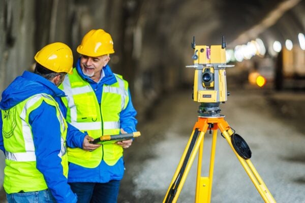
The construction of the Perca Bypass, a critical infrastructure project underway in the Italian Alps, highlights the increasing role of advanced technology in managing complex builds. Located near the village and commune of Perca — a destination known for its tourism trade — the new 632 m tunnel and supporting road network are designed to improve regional connectivity and enhance commuter safety.
The project, which began in 2023 and is expected to take three years to complete, is being delivered through a joint venture between European construction group Strabag and regional specialist Alpenbau. Once finished, the bypass is expected to relieve the flow of up to 26,000 vehicles that pass through Perca daily during peak periods, easing congestion and opening new routes for both tourism and local commerce.
Given the large number of machines, teams, and partners involved, coordinating the work requires effective management and communication tools. Alpenbau, drawing on a long-standing collaboration with Topcon Positioning Systems, the team is now using Topcon’s Aptix Integration Platform, which enables site managers to monitor and oversee progress remotely, offering real-time insights into workflow and project status without leaving their offices.
Acting with Aptix
“Aptix is a very convenient solution for us to manage our construction sites,” said Benjamin Niederkofler, CEO of Alpenbau. “One of the advantages of Aptix is that you can directly load 3D models onto machines that are equipped with machine control systems. This means that you always have the possibility to monitor the site from the office. This is a very important and fundamental tool for us to remotely monitor a construction site.”
Aptix consolidates data from different contractors and machinery, regardless of the manufacturer or operating system, and provides a comprehensive view of project performance. Senior leaders can access essential metrics in real time, such as work progress, fuel consumption, and carbon emissions, improving the ability to make informed decisions.
Control, Collaboration, Clarity
Throughout every stage — from planning and design to actual construction — the platform supports automatic workflows that deliver designs to machines and collect telematics data without manual intervention. This automation reduces the risk of missing information and helps maintain clear communication among stakeholders.
A joint effort of this scale requires constant collaboration among contractors, local authorities and other stakeholders. The Aptix platform helps facilitate transparency in workflows by allowing access to daily productivity reports and construction data, supporting open cooperation and oversight for both project managers and crew.
“Recently it has become increasingly important that we create transparency and co-operation on this construction site and share productivity daily with construction management or even with our customers,” said Niederkofler. “Having this transparency across the entire construction site is a decisive advantage.”
Andrea Marzi, technical director at Strabag Italy, added, “This unique platform allows all parties involved in the project to access all relevant construction information and data.”
Once completed, the Perca Bypass is expected to generate new economic opportunities for the region. Project leaders say that by adopting innovative digital workflows and centralized data management, they are able to direct complex operations more effectively and deliver the project with increased speed and accuracy.
Read a roundup of recent products in the GNSS and inertial positioning industry from the May 2025 issue of GPS World magazine.
SURVEYING
Integrated Navigation Solution Ideal for inspection and survey applications
Photo: Teledyne
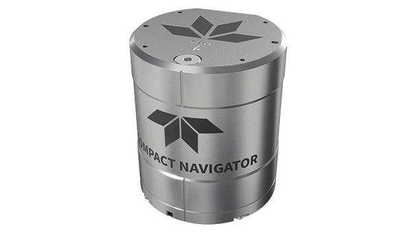
Teledyne Compact Navigator is an ultra-compact autonomous integrated navigation system engineered for subsea and surface vehicles. It is ideal for small vehicles, enabling inspection and survey operations on compact platforms. The system is offered in two depth-rated models, one capable of operating at 4,000 m and another at 300 m. The Compact Navigator consumes less than 7 watts of power, extending mission duration by conserving energy. The system operates fully autonomously, eliminating the need for external aiding or operator intervention. Advanced phased array Doppler Velocity Log technology enhances performance while allowing the device to be mounted on an autonomous underwater vehicle or ship hull.
The Compact Navigator supports a broad range of applications, including autonomus underwater vehicles, shallow water surface navigation, operations in GNSS-denied environments and dynamic positioning for surface vehicles. The system provides true North-seeking gyrocompass-grade performance, and its web-based user interface supports integration, operation and troubleshooting. It is factory-calibrated and offers a battery backup option for reliability in demanding conditions. The system operates independently of satellite signals, making it resistant to jamming or signal loss. This capability is significant for shallow water navigation, where GNSS-based systems may be unreliable.
3D Reality Capture Solution Can be used across various industries
Photo: Faro
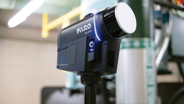
FARO Blink, a new 3D reality capture solution, is designed to make collecting and utilizing 3D data more accessible and efficient. It centers on software-driven technology integrating advanced visualization and automated workflows through the FARO Sphere XG Digital Reality Platform. This integration aims to simplify operations and deliver faster, more actionable insights for users across various industries.
FARO Blink is tailored for professionals in fields such as surveying and construction. It offers high-quality visualization and can streamline workflows, allowing teams to efficiently capture, view and share 3D data, thereby enhancing project progress and collaboration.
The MS400C is a fully integrated multibeam echosounder designed for uncrewed surface vessels. The new system combines sonar processing, inertial navigation, GNSS positioning and sound velocity sensing into a single unit.
The MS400C seeks to address deployment challenges faced by USV operators during hydrographic surveying. Its compact, lightweight design allows direct mounting on small platforms. Installation involves connecting a few cables to the IPC and power supply and to the primary and secondary GNSS antennas. With preconfigured spatial relationships, operators can deploy and start surveying quickly, reducing configuration errors and ensuring consistent data quality.
Equipped with Auto Survey functionality, the system calibrates parameters based on water conditions, which streamlines pre-survey procedures. Real-time roll compensation and attitude data from the internal measurement unit, combined with sound velocity profiling, ensure high-fidelity depth measurements, even in dynamic conditions. Designed for autonomous and remotely operated survey platforms, the MS400C supports data collection in confined waterways.
The SurveyPod RTK/PPK GNSS system is built for professionals in surveying, agriculture, mining and construction. The system integrates GPS, GLONASS, Galileo and BeiDou signals for improved satellite visibility and accuracy, even in harsh environments.
Powered by a CORS Network, SurveyPod offers real-time, centimeter-level positioning ideal for high-precision applications. The device supports tilt compensation for reliable data collection at angles and boasts up to 16 hours of battery life, making it ideal for extended field operations. With this launch, Nibrus Technologies is expanding its survey equipment portfolio, offering a Made-in-India GNSS solution to the global market.
This MEMS-based north-seeking inertial measurement unit (IMU) operates independently of GNSS. It can achieve a heading accuracy greater than 1° secant latitude without GNSS assistance. When integrated with GNSS and SBG Systems’ navigation algorithms, it can achieve INS heading accuracy greater than 0.01°.
Measuring 52 x 52 x 36 mm and weighing less than 150 g, it consumes only 2 watts of power. It offers long-term reliability in demanding conditions, and its ITAR-free status allows unrestricted global deployment. SBG Systems also has developed a new pure north-finding algorithm capable of rapid initialization in both static and dynamic conditions within one minute, as well as an advanced GNSS/INS fusion algorithm that delivers exceptional single-antenna heading accuracy even in low-dynamic environments.
The IMU is particularly suited for subsea applications, including remotely operated vehicles and autonomous underwater vehicles, as well as geospatial and marine surveying tasks requiring precise single antenna heading accuracy.
The first off-the-shelf solutions are expected to be available by early 2026. SBG Systems
Post-Processing Software With upgraded features
Photo: SBG Systems
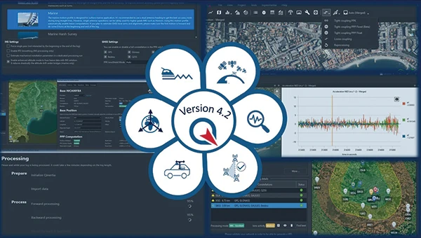
Qinertia 4.2 is an updated version of SBG Systems’ post-processing software for GNSS and INS data. One of the notable additions is the beta version of Precise Point Positioning Fixed Ambiguity, which offers centimeter-level accuracy processing without the need for a base station. The update also includes a new RTS smoothing option, the Trajectory Smoother, which enhances INS processing by removing artifacts while maintaining precision. Another feature is the standalone Lever Arm Estimation Tool, now available as a separate application with a simplified interface. The Advanced Virtual Base Station Network Creation has been enhanced with improved base station quality indicators to increase reliability.
It is compatible with the New Ellipse series and supports Teledyne Intrepid INS. The software now offers faster processing speeds, enhanced geodesy functionalities such as base station velocity analysis, and updated tools for assessing processing quality through new status plots. It also supports the latest firmware versions of Ekinox, Apogee, Navsight and Quanta systems. SBG Systems
MACHINE CONTROL
GNSS Receiver and INS System For machine guidance
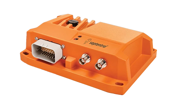
Photo: Septentrio
The AsteRx RB3 GNSS receiver and the AsteRx RBi3 GNSS/INS system are designed to operate in extreme environments. They feature IP69K-rated housings and components that have undergone ISO-standard testing.
The technology offers durability under heavy shocks, vibrations and challenging environmental conditions, making it suitable for demanding applications such as construction, mining and port automation.
The AsteRx RB3 and RBi3 utilize multi-frequency GNSS technology to deliver precise, centimeter-level positioning even in environments where GNSS signals are typically difficult to maintain. The receivers can be mounted externally on heavy machinery or integrated into chassis systems, offering flexibility in placement and simplifying installation.
The AsteRx RBi3 incorporates FUSE+ technology, which combines a high-performance GNSS engine with an industrial-grade inertial sensor. This integration provides accurate orientation data, such as heading, pitch and roll, alongside reliable positioning. In dual-antenna configurations, the receivers deliver sub-degree GNSS heading accuracy immediately upon initialization. The AsteRx RB3 and RBi3 are ideal for machine guidance in industries requiring rugged equipment to maintain precision under extreme conditions.
Handheld Reality Capture Solution For maximum mobility
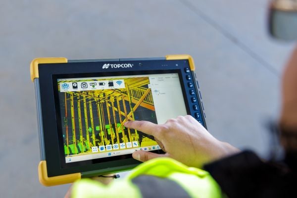
Photo: Topcon Positioning
Designed for mass data solutions, the CR-H1 utilizes PIX4Dcatch, a specialized application with integrated lidar that runs on iPhone devices. It collects images and employs photogrammetry to create detailed, full-color 3D point clouds. The iPhone connects to Topcon’s HiPer CR receiver, enabling the application to collect georeferenced images. The receiver and iPhone are mounted on a specialized handle designed and manufactured by Topcon so that users can capture point clouds without a tripod.
The CR-H1 can be used for utilities and subsurface mapping, construction verification and earthworks, civil engineering and site verification, land surveying and forensics and 3D data capture. Topnet Live subscriptions are available for the CR-H1, providing real-time GNSS corrections that deliver higher-quality point clouds.
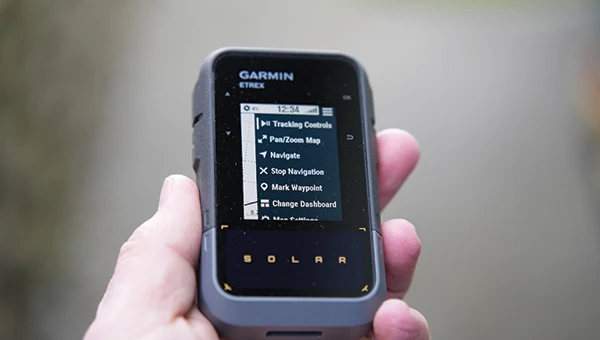
Handheld GPS Device Can provide up to 200 hours of GPS navigation on a single charge
Photo: Garmin
The Garmin eTrex Solar is a handheld GPS device with a built-in solar charging feature. This feature allows for potentially unlimited battery life in optimal sunlight conditions. Even without direct solar input, the device can provide up to 200 hours of GPS navigation on a single charge, making it suitable for extended trips with limited access to power.
The device supports GPS, GLONASS, Galileo, QZSS, IRNSS and Beidou. It features a rugged design, an IPX7 water resistance rating, and a compact, lightweight body that can be attached to a backpack or worn around the neck. Users can import GPX files and navigate to waypoints, courses and geocaches. It also includes a three-axis compass and can store up to a thousand waypoints, 50 courses and 200 activities.
Users can connect the eTrex Solar to their smartphones through the Garmin Explore app, which enables additional features such as geocaching details, weather updates, software updates, trip planning, and cloud storage syncing.
New Product Offerings Now featuring marine GNSS antennas
Photo: Geo-matching
Geo-matching has expanded its product database to include GNSS antennas. The initial marine GNSS antennas featured in this new category are the VP6300 from Calian GNSS, formerly Tallysman, and the AV34 from Trimble.
Geo-matching features detailed information on more than 1,300 products across 63 categories for surveying, navigation and machine guidance. The website is designed to guide users through complex product specifications, offering access to brochures, case studies, product videos and professional reviews. Among the many categories available on Geo-matching.com are hydrographic processing software, GNSS receivers, GIS software, inertial navigation systems, total stations, UAVs, sidescan sonars, imaging sonar and more. The platform encourages users to browse its extensive catalog, upload new products, leave reviews and register their companies to add products to the database.
Mapping UAV With a new “Smart Return-to-Home” feature
Photo: Flyability
Flyability has introduced a “Smart Return-to-Home” (RTH) feature for its Elios 3 UAV, designed to enhance its autonomous capabilities. This feature allows the UAV to return to its take-off point using the shortest available path while avoiding obstacles in real time.
During flight, Smart RTH monitors battery levels through a new flight management gauge, notifying the pilot when it is time to return. The feature is activated via Flyability’s Cockpit flight app, and pilots can take manual control at any point. By automating the return process, the system helps pilots focus on inspections without concerns about battery management or navigation in complex environments. Smart RTH uses lidar scans to generate a flight plan that the UAV executes independently.
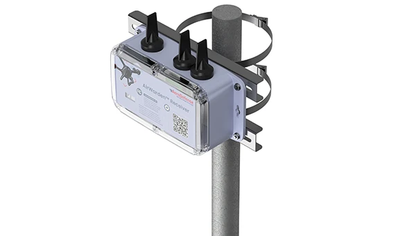
The AirWarden Remote ID Receiver detects and decodes Remote ID signals broadcast by UAVs. It is designed for organizations and authorities that need to monitor UAV activity for safety, security and compliance with regulations.
It decodes the information transmitted by UAVs in accordance with FAA and other regulatory standards. The data it captures includes the UAV’s identification number, its precise location (latitude, longitude and altitude), the takeoff location, operator location if available, timestamps, and other relevant metadata.
The AirWarden can be deployed as a standalone unit or integrated into larger security and monitoring systems. Users interact with the system through a web-based or software interface that facilitates live monitoring, alert management, and data analysis.
Additionally, the AirWarden can integrate seamlessly with other security infrastructure, such as video surveillance and access control systems. This integration seeks to improve how security teams automate responses and coordinate actions when unauthorized or suspicious drone operations are identified.
Read a roundup of recent products in the GNSS and inertial positioning industry from the March 2025 issue of GPS World magazine.
Surveying and Mapping
Photo: Eos Positioning Systems
New Eco-Friendly Carrying Case For Eos Positioning Systems’ receivers
The Skadi Gold, Skadi 300 and Skadi 200 GNSS receivers will now be shipped in a field-rugged carrying case made entirely from recycled materials. The case is designed to meet the demands of professionals who utilize GNSS technology in challenging environments. Its construction incorporates durable, eco-friendly materials that can withstand various field conditions, from remote wilderness areas to urban construction sites.
A key feature is its composition of 100% post-consumer recycled resin, which significantly reduces waste and promotes environmental sustainability, according to the company. It is specifically engineered to be shock-resistant and weatherproof.The case is provided as a standard inclusion with every purchase of the Skadi Gold, Skadi 300 or Skadi 200 GNSS receivers at no additional cost.
Multibeam Sonar Designed for bathymetric surveying
The Gemini 1200id is built on the same robust platform as the Gemini 720is multibeam sonar. The device features a 120° horizontal field of view, operating at both 720 kHz and 1,200 kHz acoustic frequencies.
The Gemini 1200id incorporates advanced noise reduction technology to significantly improve the attenuation of waterborne electrical noise to enhance imaging performance. An integrated speed-of-sound sensor ensures high positional accuracy of displayed targets, while CHIRP processing technology enhances target separation over extended ranges.
Compatibility with Tritech’s Genesis software package allows users to control multiple Tritech products from a single interface to streamline operations. The company has also made software development kits available for Windows and Linux operating systems to integrate into various platforms. The sonar’s design includes a custom-developed analog front-end solution with fully differential receiver channels, making it ideal for longer-range applications.
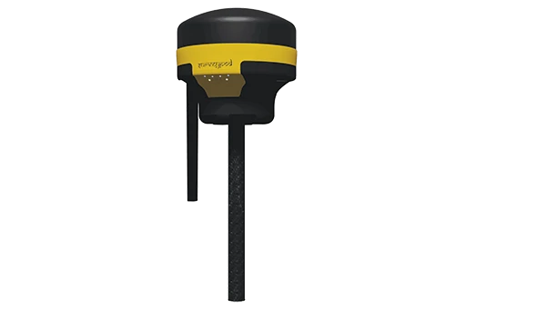
HiPer XRa is a GNSS receiver for surveying, mapping and construction applications. It can benefit a wide variety of users, including construction professionals, surveyors, geographic information systems (GIS) professionals, archeologists, engineering firms and more. The HiPer XR supports GPS, GLONASS, Galileo, BeiDou, IRNSS, QZSS and SBAS.
The new receiver has advanced Topcon Integrated Leveling Technology (TILT) compensation, featuring a calibration-free and magnetic interference-immune integrated IMU that provides up to 60° of tilt for precision measurements in challenging positions. It has signal integrity protection, anti-jamming and anti-spoofing capabilities. Through the myTopcon NOW! website, users can access online training materials, firmware updates and additional software resources.
Airborne Lidar System Ideal for coastline and river surveying
CoastalMapper is an airborne bathymetric lidar system for coastline and river surveying. The CoastalMapper can survey coastlines and rivers 250% faster than previous sensor models, according to Leica Geosystems.
It is suitable for various mapping applications, from assessing infrastructure resilience to monitoring river floods and conducting environmental investigations.
It features a high-performance bathymetric lidar module, a Leica TerrainMapper-3 topographic lidar and an imaging sensor, integrated into a compact and lightweight sensor head. This allows the CoastalMapper to capture up to 1 million bathymetric data points and 2 million topographic data points per second while providing high-resolution imagery with a 5-cm ground sampling distance at typical flying heights.
It integrates with Leica Geosystems’ airborne mapping workflows and offers cluster processing capabilities, allowing users to analyze large datasets and reduce the time from data collection to final deliverables. These outputs can include classified point clouds, digital terrain and surface models, and various imaging products.
Surveying Kit Streamlines base station and checkpoint setup
WingtraGROUND, a comprehensive survey kit, streamlines base station and checkpoint setup for on-site post-processing kinematic surveys with the WingtraONE Gen II, a vertical takeoff and landing UAV. The kit combines receivers, checkpoints and tools into a single, portable workflow.
The system integrates hardware components with a Wingtra tablet interface, which can help surveyors confirm correct receiver placement and avoid common errors associated with improper base station setup and inaccurate coordinates.
Wingtra receivers, equipped with Emlid Reach RS3 technology, provide accuracy within 2 cm, meeting high standards for aerial data validation. These receivers can also function independently for terrestrial surveys in real-time kinematic mode, including point collection and stakeout for various applications.
Galileo HAS-Enabled Receiver Offers positioning capabilities with 20 cm accuracy
The Geode GNS3H supports Galileo High Accuracy Service (HAS). It offers positioning capabilities with 20 cm accuracy worldwide without requiring additional infrastructure or subscriptions.
It is built to withstand tough conditions, making it ideal for demanding fieldwork. The device offers various accessories, including the Geode Grip, which combines the Geode with a data collection device of choice into a single handheld solution. A backpack strap kit and survey pole are also available to enhance mobility and flexibility in the field. The GNS3H can be used for surveying, agriculture, construction, forestry, mining and archaeology.
Expanded Mapping Portfolio 3D mapping technologies and more
Topcon Positioning Systems has become an authorized distributor of Pix4D’s photogrammetry software portfolio.
The partnership aims to enhance reality capture solutions across various industries, including surveying, mapping, utilities infrastructure, public safety, forensics, and architecture, engineering and construction.
The agreement streamlines the procurement process for end users by allowing them to access Pix4D’s advanced photogrammetry software solutions through Topcon’s global distribution network.
The GNSS real-time kinematic (RTK) 5 Click — a compact add-on board for high-precision positioning and navigation demands — features the UM980, an all-constellation multifrequency RTK positioning module from Unicore, with the advanced NebulasIV SoC for enhanced performance.
It supports Swift Navigation’s Skylark precise positioning service, multiple GNSS constellations and RTK positioning for centimeter-level accuracy. The board also features JamShield technology for robust performance in challenging environments, USB connectivity for easy configuration and visual status indicators for module status and GNSS signal reception.
It can be used for a variety of applications, including surveying and mapping, precision agriculture, UAVs, autonomous robots and autonomous driving.
Multi-Band GNSS Antenna Can operate in urban environments
Levity Series’ AHP24510 (L1/L2/L-Band) and AHP54510 (L1/L5/L-Band) directional patch antennas are designed to receive signals from GPS, Galileo, GLONASS and BeiDou satellite constellations.
These antennas offer faster and more accurate signal acquisition and lock, specifically in urban environments. The L-Band capability allows compatibility with high-precision GNSS correction services. The multi-band antennas offer integral redundancy to minimize satellite security blind spots and reduce energy consumption due to faster acquisition, requiring less system uptime to save power.
The Levity Series active antennas feature a 45 mm x 45 mm x 10 mm wide-band, dual-stacked patch design with a dual-feed, low noise amplifier, providing 28 dB to 29 dB gain and filtering. They operate with a maximum antenna VSWR of 1-to-1 from 1,207 MHz to 1,603 MHz, and the passive antenna efficiency ranges from 39.93% to 68.51% in the L1 band. These antennas use right-hand circular polarization to mitigate multi-path interference.
The Levity Series includes other multi-band products for high-precision applications, such as the HP24510A and HP54510A stacked-patch passive components, and the TFM.120A surface-mount front-end module, which covers the full multi-band GNSS spectrum including L-band. These antennas are suitable for various applications, including wearables, transportation, robotics, precision agriculture and autonomous vehicles.
The M9PLUS-HCT-A-SMA is an active multi-frequency GNSS antenna designed for high-accuracy applications. It supports L1/L2/L5 GPS, Galileo, Beidou and GLONASS bands, as well as L-band correction services. The antenna utilizes Maxtena’s proprietary Helicore technology, which offers advanced pattern control, polarization purity and efficiency in a compact form factor.
It integrates a pre-filter specifically engineered to mitigate LTE interference. This is crucial for maintaining signal integrity in environments with dense mobile communication networks, where LTE signals can overlap with GNSS frequencies. The pre-filter can effectively block out-of-band LTE signals, reducing intermodulation risks and ensuring clear GNSS signal reception.
The M9PLUS-HCT-A-SMA is built with rugged, IP67 automotive-grade components and includes an integrated SMA connector. It also features an O-ring for enhanced environmental sealing. Weighing only 24 grams, the antenna is ground plane-independent, making it versatile for various installations. It is particularly well-suited for GIS and RTK applications where high accuracy and reliability are crucial.
The MostaTech G321M is a three-axis fiber optic gyroscope (FOG) that offers high-precision navigation and orientation measurement capabilities. This advanced sensor features a data rate of 8 kHz.
Key features of the G321M include an input range of 400° per second, a bias RMS of 1° per hour and an angular random walk of 0.025 °/√h. Additionally, it has a power consumption of 2 W and an initialization time of 1 second. The G321M is designed with a compact form factor, making it suitable for various applications where size and weight are critical factors.
It is ideal for UAVs, robotics, borehole surveys, image stabilization, gimbal stabilization and underwater vehicles.
High-Precision Lidar Designed for precision applications
The TV1 Lite and the TV1 UAV systems are designed for various precision applications, such as mapping and data collection.
The TV1 Lite features TrueNav technology, a Hesai 32-channel laser scanner and a FLIR 5MP global shutter camera with a 90° field of view. It also includes one year of TV1 Lite Annual Processing with support and maintenance.
TV1 offers customization options, allowing users to choose from 26 MP, 45 MP or 61 MP cameras and various Trajectory Correction Service options.
Flight Control System With autopilot functionality
The Prism Supervisor software combines UAV autopilot flight control systems with AI-based observations processed in real time, aiming to enhance UAV operations.
The system provides a programming framework and software development kit for users to create custom mission scenarios. During flight, Prism Supervisor can adapt its autopilot functionality in real time, generating mission segments and flight plans as needed.
The software features a user-friendly graphic interface for mission planning, real-time visualization and execution. It supports Windows, Linux, macOS, iOS and Android.
Remote ID Receiver Enhances airspace awareness and UAV safety
RIDER is designed to enhance situational awareness by providing real-time detection of UAV activity in sensitive areas. It also seeks to provide a clear visibility of surrounding UAV operations to help avoid potential collisions and ensure safer flight experiences.
The device features a built-in industrial chip SIM that provides global coverage through LTE-M and NB-IoT, ensuring connectivity in various environments.
It operates effectively within a temperature range of -20 °C to +60 °C and is rated IP54 for dust and water resistance. The device complies with ASTM F3411-22A and ASD-STAN EN 4709-002 standards, making it suitable for regulatory environments.
The RIDER can detect signals from up to 5 km with its default antennas and up to 10 km when using an optional high-performance antenna. It is equipped with an internal cellular and Bluetooth antenna, along with an integrated GNSS antenna that provides precise positioning and timestamping capabilities. It supports multiple GNSS frequencies and utilizes Bluetooth and Wi-Fi technologies for Remote ID communications.
Streamlined BVLOS Operations For a variety of applications
The Sentaero 6 UAV is designed for advanced over-the-horizon operations beyond visual line of sight (OTH-BVLOS). It features built-in AI and machine learning capabilities for real-time data processing. The system can be used for surveying, mapping, inspection, asset monitoring and more.
Engineered to streamline operations, the Sentaero 6 offers more accurate and up-to-date intelligence on assets. Its onboard computer can processes data mid-flight.
Future developments will include swarm operations, enabling one human to control multiple UAVs simultaneously; fully remote operations and higher safety standards, such as a parachute for urban missions, according to Censys Technologies.
SBG Systems has significantly updated its Ellipse series sensors, incorporating the latest World Magnetic Model (WMM) to enhance accuracy and reliability in navigation applications. This upgrade is available for all Ellipse sensors, including first-generation models.
Designed for unmanned systems such as UAVs, UGVs and marine platforms, the Ellipse series comprises compact, high-precision inertial sensors. These devices feature built-in three-axis magnetometers that measure Earth’s magnetic field, crucial for accurate heading and positioning data.
Updated every five years, the WMM is a globally recognized mathematical representation of Earth’s magnetic field. The latest version, released in December 2024, ensures precise heading and positioning corrections to account for ongoing geomagnetic changes.
NDAA-Compliant UAV Now integrated with ArcGIS Flight
Esri now supports the Astro Max UAV in its ArcGIS Flight application. The Astro Max is the first Blue UAS-cleared and NDAA-compliant UAV to integrate with Esri’s platform.
The Astro Max, developed by Esri partner Freefly Systems, adheres to the security and performance standards set by the National Defense Authorization Act and the Defense Innovation Unit’s Blue UAS initiative. This industrial UAV is designed to enhance the capabilities of government and enterprise users utilizing ArcGIS Flight.
Autonomous Swarm Control Controls various autonomous platforms
The Autonomous Multi-Domain Operations Resiliency Platform for Heterogeneous Unmanned Swarms (AMORPHOUS) software features a single-user interface to operate thousands of autonomous assets simultaneously. Designed with an open architecture, this software enables the U.S. and allied militaries to control a mix of uncrewed platforms, payloads and systems.
AMORPHOUS includes an intuitive and distributed command-and-control interface to give operators the flexibility to conduct a wider array of intricate military missions. This collaborative autonomy at scale will provide warfighters with a decisive overmatch capability.
L3Harris is developing prototypes using the AMORPHOUS architecture on contracts for the U.S. Army and the Defense Innovation Unit. AMORPHOUS has demonstrated flexibility and interoperability by controlling multiple, separate assets across multiple vehicle types operating in different domains during government-managed tests.
AMORPHOUS supports decentralized decision-making, which enables individual, uncrewed assets to perform tasks autonomously and make real-time tactical decisions inside the network.
Advanced Counter-UAV Radar Multi-console radar control and display system
Cambridge Pixel has developed a radar control and display system for Weibel Scientific’s XENTA surveillance radar, which is designed for modern air defense and counter-unmanned aerial systems (C-UAS) applications.
The XENTA radar includes 3D target tracking, continuous target illumination and synthetic receiver beamforming. It is available in two configurations: the XENTA-M for short-range air defense and the XENTA-C for C-UAS operations.
The system is designed to work seamlessly with third-party command-and-control systems, enhancing operational efficiency.
Cambridge Pixel’s library of radar processing software allows users to develop a tailored radar controller specific to the XENTA radar’s requirements. Enhancements were made to existing functionalities, such as improved MIL-STD-2525 overlay graphics and support for dual-redundant operator consoles.
The XENTA radar system can detect small UAVs at distances exceeding 7 km and classify them beyond 5 km. This capability makes it suitable for various applications, including airport security, border control, critical infrastructure protection and event security.
The Pelican 2 agricultural spray UAV has an expanded 300-liter payload capacity and can cover up to 5.3 ha/hr.
It incorporates several technological enhancements designed to meet the demands of agriculture applications. The aircraft features an upgraded four-motor electric propulsion system, a wider 18-m spray swath and advanced lidar and radar systems for fully autonomous day-and-night spraying. These improvements aim to increase efficiency and precision in aerial application while reducing operational costs for farmers.
The Pelican 2’s airframe and structural components are constructed from carbon fiber composites, corrosion-resistant metallic components and 3D-printed assemblies.
Topcon Corporation and FARO Technologies have entered a strategic partnership to develop and distribute laser-scanning technology solutions. The collaboration aims to expand access to advanced digital reality tools and result in complementary product developments, such as integrating Topcon and Sokkia systems with FARO products.
The initiative focuses on advancing laser-scanning technologies across key sectors, including construction, surveying, mapping, architecture, forensics, building information modeling and industrial plant and process applications. By combining their expertise, the companies plan to enhance software integration and develop joint product solutions to address user needs more effectively.