Tag: u-blox

  • U-blox positioning enables massive drone light show

    U-blox positioning enables massive drone light show

    The 10-minute-long drone show included a flying dove with a wingspan of 600 meters, visible from three kilometers away. (Photo: u-blox)
    The 10-minute-long drone show included a flying dove with a wingspan of 600 meters, visible from three kilometers away. (Photo: u-blox)

    U-blox supplied the high-accuracy technology that made it possible to fly a massive swarm of drones. The simultaneous flight of 2,198 miniature unmanned aerial vehicles (UAVs) was launched into the night sky over Saint Petersburg, Russia, on Sept. 3.

    The 10-minute-long drone show included a flying dove with a wingspan of 600 meters, visible from three kilometers away.

    Geoscan, which built and programmed the drones and ran the display, chose u-blox positioning technology for its combination of accuracy, reliability, performance and ability to access positional data from both the GLONASS and GPS satellite navigation constellations.

    The 10-centimeter-wide Geoscan Salute drones were designed for use in group flights and drone shows. The drones use u-blox NEO-M8P high-precision GNSS modules to provide the positioning data to create a fluid drone show. Salute drones return to their base stations automatically at the end of a show.

    The NEO-M8P module implements a real-time kinematic (RTK) approach that improves positional accuracy by comparing the phase of a signal being broadcast from a positioning satellite with that of the same signal that has been received and rebroadcast from a fixed base station. The accuracy gained in this way enables drones to calculate their relative positions to within millimeters, and their absolute positions to within 1 centimeter of the intended position.

    Geoscan has been producing drone displays for the past two years, starting with 40 drones flying at once. “The u-blox modules in our Geoscan Salute drones have improved our drones’ positioning accuracies to about one centimeter, and have helped reduce pre-launch preparation time,” said Semen Lapko, head of Drone Show Project, Geoscan. “Drones now move more quickly and accurately, while also operating more efficiently.”

  • U-blox provides LPWA IoT security to system engineers

    U-blox provides LPWA IoT security to system engineers

    Image: metamorworks/iStock/Getty Images Plus/Getty Images
    Image: metamorworks/iStock/Getty Images Plus/Getty Images

    U‑blox has launched a commercial internet of things (IoT) Security-as-a-Service offering. Available on both the u‑blox SARA-R4 and SARA-R5 series of LTE-M cellular IoT modules, the service protects data from malicious third parties, both on the device and during transmission from the device to the cloud, u-blox said in a press release.

    Both the SARA-R4 and R5 have integrated M8 GNSS receivers.

    The IoT Security-as-a-Service provides an out-of-the box onboarding process to cloud IoT platforms to speed up development, shortening time-to-market.

    The IoT Security-as-a-Service offering, which is managed via the u‑blox Thingstream service delivery platform, is specifically optimized for low-power, wide-area (LPWA) deployments that use resource-constrained IoT devices. By substantially reducing data overhead and keeping the number of handshakes to a minimum, the service improves power consumption and extends the battery life, a critical metric for most IoT devices.

    u-blox acquired Thingstream, an IoT communication-as-a-service provider, in April.

    Central to the effectiveness of the solution is a unique symmetric key management system (KMS). Through it, an infinite number of crypto keys can be generated on the fly for each device, rather than having to rely on the storage and management of pre-shared keys (which can add to overall operational complexity and the power budget).

    Keys are tied to the hardware and can be triggered from either the module or from the server/cloud, completely eliminating the need to create, deliver, and renew certificates, and bringing significant savings in terms of system cost, operational complexity, and power consumption.

    The solution also leverages u‑blox’s Foundation security offering, which comprises fundamental elements that make SARA-R4 and SARA-R5 modules secure by design. These include a unique and immutable device identity that is tied to its root of trust (RoT), which forms the basis for a trusted set of advanced security functionality, including a secure boot mechanism that ensures that the module can only run trusted software. In addition, u‑blox’s proprietary uFOTA feature enables authentication of over-the-air firmware updates.

    Among the relevant use cases that u‑blox IoT Security-as-a-Service can support are:

    • Asset tracking. Data authenticity is essential in such scenarios, as well as secure local storage of collected data and easy secure cloud onboarding. Because tracking devices are usually battery powered, they require extremely energy-efficient secure data transmission.
    • Connected health/eHealth. In this use case, patient confidentiality is paramount, with only authorized medical staff permitted to access sensitive data. This necessitates a high degree of protection against malware and data tampering.
    • Industrial monitoring. These solutions need to guarantee the integrity of real-time operational data to increase productivity, avoid downtime, and assure the safety of the workforce.
    • Building and home automation. Data confidentiality and authenticity need to be maintained, while allowing for data to be shared with trusted stakeholders without compromising customer privacy.
    • Telematics. In this scenario, the main security risks include denial-of-service (DoS) attacks, device cloning, jamming, etc.
    • Smart metering. Here, the authenticity of data logged by remote metering units needs to be confirmed to protect billing, and, once trusted communication is established, data transmission needs to be restricted to authorized servers.

    “We implemented a true end-to-end concept that protects data from the device to the end user without making it visible to intermediate nodes or platforms, or to service providers. The modules’ symmetric KMS offers engineers a streamlined and scalable alternative to conventional public key infrastructure or pre-shared key arrangements,” says Giovanni Solito, senior product manager, Product Center Services at u‑blox. “And with straightforward onboarding to all the popular cloud IoT platforms, efforts are not taken up by security concerns and operational complexities, but can be focused on speeding up time to market and growing business.”

  • New Taoglas antennas aimed at robotics, autonomous vehicles

    New Taoglas antennas aimed at robotics, autonomous vehicles

    Taoglas has unveiled active, multiband GNSS antennas engineered for applications that require critical high-accuracy positioning and timing, including autonomous driving and precision agriculture. Both the MagmaX2 AA.200 and Colosseum X XAHP.50 add to Taoglas’ high-precision GNSS range.

    “Safety standards for autonomous vehicles (UAVs, robotics and vehicles) and precision agriculture is an ever evolving arena,” said Ronan Quinlan, co-CEO and founder of Taoglas. “However, it’s increasingly apparent that high-precision positional accuracy is critical for both. At Taoglas we’re continuously innovating our GNSS antennas to deliver the very best precise location capabilities, but in more lightweight, compact structures, compared to larger counterparts already on the market. We look at the impact the antenna has on the actual positioning performance of your system, not just the antenna itself.”

    The MagmaX2 AA.200. (Photo: Taoglas)
    The MagmaX2 AA.200. (Photo: Taoglas)

    The MagmaX2 AA.200 is designed for space and weight constrained applications, such as robotic lawnmowers, Quinlan said. Embedded antenna versions are also available.

    The AA.200 is a low-profile active multiband GNSS magnetic mount antenna for use across most major constellations including GPS (L1/L2/L5), GLONASS (G1/G2/G5), Galileo(E1/E5a/E5b) and BeiDou(B1/B2). It exhibits excellent gain and good radiation pattern stability leading to a reliable GPS fix in areas of weaker signal strength.

    Positional accuracy better than 60 cm (DRMS) is achievable, even without RTK corrections services. Accurate positioning down to 1.4 cm has been demonstrated with today’s multiband GNSS receivers and RTK services in the field.

    The Colosseum X XAHP.50 antenna. (Photo: Taoglas)
    The Colosseum X XAHP.50 antenna. (Photo: Taoglas)

    The Colosseum X XAHP.50 is a geodetic-quality small-dome antenna suitable for a vehicle roof mount or pole mount. “Every element and aspect of the antenna performance has been optimized during the design of this antenna,” Quinlan said. “This includes many deep interlocking rf parameters for true accurate centimeter-level positioning, compared to legacy meter-only level systems. Phase center variation, group delay, multipath rejection, axial ratio over angle all become critical considerations and performance targets.”

    The XAHP.50 is engineered to operate with incredibly high precision capabilities on the full GNSS spectrum. Sub meter positional accuracy better than 55cm (DRMS) is achievable, even without the use of RTK correctional services. This allows the user to achieve higher location accuracy, as well as stability of position tracking in urban environments.

    The XAHP.50 has excellent performance across the full bandwidth of the antenna and its design has an even gain across the hemisphere giving excellent, broad axial ratio which in turn makes it resilient to multipath rejection and excellent phase centre stability. Accurate positioning down to 1.4 cm has been demonstrated with today’s multiband GNSS receivers and RTK services in the field.

    Antenna Development

    “In the design phase we simulate using electromagnetic analysis software and tweak every parameter,” Quinlan said. “Once we are happy with the results, we build our prototypes and test in scientifically controlled chamber and test environments validated by the European Space Agency, with repeatable GNSS signals.

    “We then move onto field testing in open-sky conditions and in non-line of sight environments to verify real-world performance with today’s state-of-the-art receiver systems from such leading companies as u-blox and Septentrio.

    What’s more, every single antenna coming off our production line goes through strict in-line sensitivity testing to ensure consistent validated performance. We take our commitment to quality and safety very seriously in the coming age of autonomous operation,” Quinlan concluded.

  • Inertial Labs releases INS-DU GPS-aided unit for high-accuracy positioning

    Inertial Labs releases INS-DU GPS-aided unit for high-accuracy positioning

    The new INS-DU delivers high-accuracy RTK positioning for air, land and marine applications

    Photo: Inertial Labs
    Photo: Inertial Labs

    Inertial Labs has released a new GPS-aided inertial navigation system (INS). The INS-DU is a high-performance strapdown system that determines position, velocity and absolute orientation to any platform it is mounted to.

    The INS-DU has a dual-antenna u-blox GNSS receiver that provides 1-cm real-time kinematic (RTK) position from RTCM 3 RTK corrections and supports a wide range of GNSS constellations.

    Designed for UAVs, land vehicles and marine vessels, the INS-DU is an effective, low-cost solution that uses a range of aiding data for different applications. With highly accurate navigation in GNSS-denied environments, the INS-DU delivers a cost-effective GNSS-denied solution, according to Inertial Labs.

    One of the key elements to the success of the INS-DU is its use of the miniAHRS, which utilizes 3-axes each of precision magnetometers, accelerometers and gyroscopes to provide orientation of the device under measure. It contains cutting-edge algorithms for the motion of robots, unmanned and autonomous vehicles, and antennas.

    MiniAHRS mini fluxgate magnetometers have an advantage over commonly used magneto-inductive or magneto-resistive alternatives and have been a trusted North reference for more than 70 years.

    The INS-DU provides a full navigation solution for both GNSS and GNSS-denied environments. With custom interfaces and a power consumption of two and a half of a Watts, the INS-DU is a versatile solution fit for a wide variety of users with power consumption restrictions.

    In addition, the INS-DU contains our on-board sensor-fusion filter, state-of-the-art navigation, and guidance algorithms and calibration software.

  • Lanner computer with GNSS certified for rolling rail stock

    Lanner computer with GNSS certified for rolling rail stock

    Photo: Lanner
    Photo: Lanner

    Lanner Electronics Inc., a designer and manufacturer of network appliances and intelligent edge computing platforms, has launched the R3S series of rugged, EN-50155-certified fanless vehicle/rail computers.

    The R3S is equipped with a u-blox NEO-M8N module, which receives GPS, Galileo, GLONASS and BeiDou with the default set for GPS + GLONASS dual band.

    Powered by Intel Atom x7-E3950 processor (formerly Apollo Lake) and Intel HD graphics 505 processor, R3S series offers power-efficient performance for consolidating the in-vehicle workloads such as video surveillance, control/monitoring, passenger information, and Wi-Fi hotspot sharing.

    To ensure proper operations in moving vehicles, R3S series is certified with EN50155, EN50121-3-2, EN50121-4, EN50125-3 and EN45545 standard, E13 standard and has passed MIL-STD-810G shock and vibration resistance certifications. R3S series can operate under wide operating temperature range (-40~70° C) and 24~36/72~110 voltage input, indicating its excellent reliability in harsh railway settings.

    Designed for in-vehicle surveillance, the new R3S series equip with 6x M12-protected PoE ports (any 3 or 4 ports can support IEEE 802.3at PoE+) for IP camera or wireless access point connection and one external removable 2.5-inch HDD/SSD drive bay for recorded footage storage.

    For edge-to-cloud connectivity, R3S uses its internal GPS/GLONASS chipsets for GPS tracking and has two M.2 slots with up to 4x SIM card readers for failover LTE connection.

    For consolidating the in-vehicle workloads such as in-vehicle control/monitoring and passenger information, R3S features a variety of I/O support, including 2x HDMI, DI/DO, 3x COM/CAN BUS and 4xUSB ports.

  • U-blox technology platforms support BeiDou-3

    U-blox technology platforms support BeiDou-3

    logoCurrent u-blox GNSS platforms — from u-blox M8 and beyond — support the recently completed BeiDou navigation satellite system modernizations, improving the availability of GNSS positioning services.

    The opening ceremony of the BeiDou-3 global navigation satellite system (GNSS) was held in Beijing on July 31, officially celebrating the expansion of coverage offered by the critical Chinese space infrastructure to a global user base.

    As a global supplier of GNSS positioning and wireless communication technologies, u-blox has been driving technological innovation and deeply involved in the Chinese market for many years.

    Tests conducted across China and Europe have shown that including the BeiDou system can improve the positioning accuracy of GNSS receivers when multiple navigation satellite systems are tracked concurrently. When signals are partially obstructed, positioning accuracy can be significantly improved by incorporating the BeiDou system.

    Data shows that in 2019, the overall output value of the Chinese satellite navigation and location service industry reached nearly 345 billion yuan, an increase of 14.4% over 2018, with the output value expected to exceed 400 billion yuan in 2020.

    Chart: China Satellite Navigation System Management Office Test Evaluation Research Center
    Graphic: China Satellite Navigation System Management Office Test Evaluation Research Center

    Additional Services Provided by BeiDou

    The BeiDou system provides a suite of additional services, including satellite and ground-based augmentation services, precise single-point positioning, precise timing and global short message services, laying a solid foundation for BeiDou’s ubiquitous navigation and tracking applications.

    Applications of GNSS technology continue to diversify, leveraging the all-weather, all-time, tracking, navigation and timing services it offers. GNSS technology is penetrating deeper into traditional industrial verticals, such as agriculture, forestry, animal husbandry and fishery, power and energy, as well as in railway and air transportation, including their infrastructure construction and management.

    At the same time, GNSS technology has become an indispensable and “smart” factor in emerging application fields such as the internet of things and the “internet of vehicles,” as well as in innovative applications such as autonomous driving, automatic parking and automatic logistics, and is now commonplace in many industrial and consumer use cases.

    “U-blox has been closely following the modernization of the BeiDou navigation system and is ready to work with partners in various industries to promote the expansion of industry applications, expand emerging markets and jointly create a green industry ecosystem,” said Hamilton Chen, China country manager at u-blox.

  • Cohda Wireless partners with u-blox on next-generation V2X

    Cohda Wireless partners with u-blox on next-generation V2X

    Cohda Wireless has partnered with u-blox to produce an advanced V2X solution for the global Cooperative Intelligent Transport market. With the partnership, Cohda’s V2X software stack will support the u-blox UBX-P3 DSRC/802.11p V2X chip.

    Cohda Wireless and u-blox have a long-standing relationship and share a common vision of leveraging wireless technology to reduce the number of road accidents and fatalities across the globe.

    The u-blox chip enables wireless vehicle-to-vehicle (V2V) and vehicle-to-infrastructure (V2I) communication, now enhanced with Cohda’s hardware-agnostic software applications.

    Cohda said its software is widely deployed in the industry, providing 360° awareness and detecting hidden threats beyond anything a driver or on-board sensors can see.

    Cohda Wireless Chief Engineer Fabien Cure said that the partnership offers the market an advanced V2X solution that will be of particular interest to Tier 1 auto makers, OEMs and road authority suppliers.

    “In order to progress vehicle safety, OEMs need to produce vehicles that have embedded V2X wireless communication technology as a standard inclusion,” Cure explained. “Likewise, cities around the world are preparing for the introduction of wide scale cooperative intelligent transport systems.”

    Cohda’s V2X software is in production vehicles of GM and Volkswagen.

    “Connectedness is the key to safer roads and highways around the world and a technology solution of this calibre is an enabler of further trials and development in this sector that we warmly welcome,” added Mr Cure.

    “The porting of Cohda’s leading V2X onto our high-performance UBX-P3 chip is an important proof point that both our solutions are interoperable and enable a swift integration into automotive platforms,” said Herbert Blaser, senior director, Product Center Short Range Radio at u-blox.

    Cohda’s software products are applied in more than 60 percent of all V2X field trials in the world today in compliance with U.S. Federal Communications Commission and European Telecommunications Standards Institute (ETSI) standards.

    “When we connect vehicles to each other and to roadside infrastructure, we are creating an intelligent and integrated road transport system that has the potential to reduce road accidents simply because the technology is capable of things humans aren’t,” added Cure.

    Image: Cohda Wireless
    Image: Cohda Wireless
  • GNSS helps fight coronavirus while companies adapt

    GNSS helps fight coronavirus while companies adapt

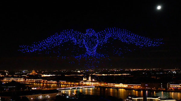
    As part of the effort to combat the spread of COVID-19 in the United States, UAV company Draganfly has partnered with Australia’s Department of Defense (DOD), the University of South Australia (UniSA) and Vital Intelligence, a company that collects and analyzes healthcare data, to remotely detect and monitor people with infectious and respiratory conditions.

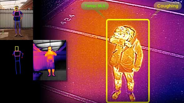
    Draganfly’s UAVs will be fitted with a specialized sensor and computer vision system that can monitor people’s temperature, heart rate, and respiratory rate, as well as detect people sneezing and coughing in crowds. The collaboration, called The Vital Intelligence Project, utilizes technology developed with help from the DOD’s Science and Technology Group. Draganfly was selected as the exclusive integration partner on March 25, with an initial budget of up to $1.5 million to commercialize and deploy the technology.

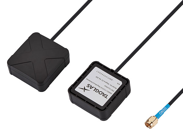
    The UAV uses u-blox LEA-M8S GNSS modules integrated into the company’s own interface printed circuit boards.

    In late January, recalled Draganfly’s CEO Cameron Chell, the company began to consider what kinds of health data it could collect and analyze that could help public officials and private-sector managers flatten the pandemic’s curve. It then contacted Javaan Chahl, a UniSA researcher who had been a customer for 20 years, to discuss the use of UAVs for this mission.

    The technology was originally designed to be deployed on helicopters in disaster relief operations, to measure the vital signs of survivors. It was then adapted to measure the health of wildlife populations, such as herds migrating or threatened by drought or fire, and in hospital neonatal wards to monitor the vital signs of newborns.

    To provide core temperature readings as well as measurements of heart rate and respiratory rate, the technology uses RGB and thermal cameras, both fixed and mounted on UAVs. “The public sector and the private sector are both interested in this technology, but are approaching it very differently,” Chell said.

    The system’s capabilities include detecting people who are coughing, not wearing masks, or clustering in violation of social-distancing rules. The objective is to provide population health information to public agencies to help them make better decisions by measuring the effectiveness of their COVID-19 policies in real time, rather than react to past information. The system, Chell stressed, does not record data on individuals but reports such figures as “84% of the people are socially distancing 24% of the time.”

    “Based on what I see unfolding with the measurement and data industry as it relates to health technology,” Chell said, “six or eight months from now you are likely to see health measurement reports the same way that you see weather reports. Eventually, it will be broadcast to the consumer. That is our objective.” People, he predicts, will use these reports to make decisions about where and when to travel.

    To obtain accurate core temperatures, Draganfly’s thermal sensor needs to be about 20 feet away from its subject, and uses software to zoom in on the tear ducts. To obtain heart and respiratory rates requires about 25 seconds of footage with at least a 4K camera, magnification to detect body micromovements, and machine vision to detect skin tone biometric measurements. The system also picks up movements — such as of the shoulders, lumbar area and upper torso — that indicate coughing, Chell points out. “The results certainly have been promising in terms of having real quantitative data,” he said.

    The scenario is somewhat different in the private sector, which typically relies more on fixed-based cameras for entranceways — for example, to monitor workers entering a warehouse, a factory or a shipyard to guard against people who are infectious or have a respiratory disease. “We have seen several announcements by companies that they are using thermal cameras to do this,” Chell said. People pass through the company’s fixed system, which uses both thermal and RGB cameras, in less than three seconds, according to Chell, which is good for such facilities as parks, office buildings and convention centers. Private organizations can then ask people who exhibit certain symptoms to consent to a secondary screening in exchange for access.

    Additionally, Draganfly will provide UAV services for disinfecting outdoor facilities.


    Find out how more companies are helping fight COVID-19.


    Featured photo: Draganfly

  • U-blox SARA-R4 cellular modules integrates GNSS technology

    U-blox SARA-R4 cellular modules integrates GNSS technology

    Photo: u-blox
    Photo: u-blox

    U-blox, a global provider of leading positioning and wireless communication technologies, has extended its SARA-R4 family of LTE-M / NB-IoT and EGPRS cellular modules to include variants with the hardware and software features necessary to enable end-to-end security features and services for internet of things (IoT) data, devices and ecosystems.

    “The new SARA-R422 product series offers superior security protection, industrial output power to grant best coverage even in weak signal conditions, and everywhere location using state-of-the-art u-blox GNSS technology,” said Rado Sustersic, senior product manager, Product Center Cellular at u‑blox. “These represent valuable functionalities tailored specifically to the LPWA IoT market.”

    M8 GNSS. The SARA-R422M8S is pre-integrated with the u-blox M8 GNSS (global navigation satellite system) receiver and a separate GNSS antenna interface. This provides highly reliable, accurate positioning data simultaneously with LTE communications.

    The module also supports hybrid positioning strategies, in which positioning data provided by satellite constellations is enhanced with data from the u-blox CellLocate service, ensuring that location data is always available everywhere.

    The SARA-R4 series is designed for a wide range of mission-critical IoT solutions such as connected healthcare, industrial monitoring, point of sale and vending terminals, tracking and telematics devices, as well as smart lighting solutions and building automation.

    Security. Security features include a unique and immutable root of trust (RoT) for each device, as well as access to a scalable pre-shared key (PSK) management system. This provides the foundation for a trusted set of advanced security functionalities to enable data encryption and decryption, both on‑device as well as from‑device‑to‑cloud.

    The choice of PSK-based security, rather than the more complex and computationally intensive public key infrastructure (PKI) approach, strikes the right balance between implementation costs and level of security protection for many IoT applications.

    Robustness. All SARA-R422 modules provide 23-dBm output power, allowing the end device to properly operate in all network conditions. This means no issues at cell edges, no coverage issues in weak signal conditions, and, even more importantly, no unwanted re-transmission that shortens battery life by increasing transmit time and overall system power consumption.

    The series is designed for long working lifetimes in the field, through the inclusion of support for LWM2M, a lightweight machine-to-machine communications protocol ideal for IoT applications with the possibility of updating the firmware of modules already in the field over the air via the uFOTA (Firmware Over The Air) client/server firmware service provided by u-blox.

    The u-blox SARA-R4 series will be presented at Embedded World in Nuremberg, Germany, Feb. 25-27, at Hall 3/Stand 3-139.

  • U-blox L-band receiver enables cm-level positioning for mass market

    U-blox L-band receiver enables cm-level positioning for mass market

    Photo: u-blox
    Photo: u-blox

    U-blox said its new NEO-D9S GNSS correction data receiver module provides an affordable approach to bringing centimeter-level accuracy to GNSS receivers.

    The NEO-D9S receives from correction service providers broadcast on the L-band (1525-1559 MHz). A host processor can then decrypt this correction data and provide it to a high-precision GNSS receiver, combining corrections directly with readings from the satellite constellations to enable much more accurate position readings than those offered by GNSS signals alone.

    Use of the NEO-D9S will also increase the availability of high-precision GNSS positioning data in areas with limited connectivity and reduce the amount of cellular data consumed by positioning receivers.

    Customers are expected to include carmakers, both Tier 1 and OEMs, industrial system integrators that offer position-correction services, and any other applications that rely on very accurate positioning at low cost.

    The NEO-D9S module is a correction-only receiver, based on the latest u-blox ninth-generation (D9) platform. This means that it will integrate easily with the u-blox F9 RTK GNSS receivers from u-blox, or can be used as part of a modular product roadmap. The module also integrates a TCXO and SAW filter to ensure good RF sensitivity and resilience to interference from adjacent channels.

    The module includes the algorithms necessary to decode satellite data broadcasts. It is configured to work initially with whichever correction service has been set as default, but can be configured for any L-band data broadcast. It stores its configuration settings in non-volatile memory.

  • CubeSat finds its way in space with Galileo receiver

    CubeSat finds its way in space with Galileo receiver

    A miniature CubeSat has become the first satellite to perform Galileo-based position fixes in orbit using a commercial satnav receiver.

    News from the European Space Agency

    Swiss start-up Astrocast launched successfully its first test satellite from Vandenberg Air Force Base, 4 December 2018. (Photo: ESA)
    Swiss start-up Astrocast launched successfully its first test satellite from Vandenberg Air Force Base, 4 December 2018. (Photo: ESA)

    CubeSats are nanosatellites based on standardised 10 cm-sized units. Originally devised for educational uses, they are nowadays being put to commercial and technology testing uses. The Swiss Astrocast company is assembling a constellation based on 3-unit CubeSats to serve the emerging internet of things (IoT).

    Vigilant for new initiatives that foster innovation in the field of navigation, ESA navigation researchers supported Switzerland’s ETH Zurich technical university to fly a navigation payload — composed of four low-cost multi-constellation mass-market satnav receiver modules plus two antennas — aboard a test CubeSat.

    “This mission has demonstrated the first use of Galileo to perform positioning and timing in orbit supporting precise orbit determination using a commercial product developed for ground users,” explains ESA’s Global Navigation Satellite Systems (GNSS) R&D Principal Engineer Roberto Prieto Cerdeira.

    “The purpose of this initiative was to demonstrate the capabilities of Galileo in orbit with a small, low-cost, low-power European satnav receiver. This will pave the way for future navigation experimentation, scientific experiments and technology demonstrations of Galileo in orbit with CubeSats and low-cost receivers for scientific activities.

    This Astrocast CubeSat launched in December 2018 included a test satnav receiver. (Image: ESA)
    This Astrocast CubeSat launched in December 2018 included a test satnav receiver. (Image: ESA)

    “The navigation payload is also capable of performing position fixes by combining Galileo with the US GPS, Russian Glonass and Chinese BeiDou systems for increased performance.”

    ESA R&D navigation engineer Rok Dittrich adds, “The receiver itself was not specially developed and tested for space but is a modified version of a low-cost mass-market product from the Swiss u-blox company. It underwent ground testing emulating its use in space, along with firmware added to take into account the dynamics of low-Earth orbit.”

    This opportunity, funded through ESA’s European GNSS Evolution programme, was conceived together with ESA’s Galileo Science Advisory Committee, a group of scientists advising ESA on scientific matters related to Galileo and fostering its scientific exploitation.

    This first AstroCast CubeSat was launched in December 2018, and the first results confirming the use of Galileo satellites for positioning were reported at the recent Galileo Science Colloquium in Zurich, typically demonstrating orbital positioning precision down to less than 5 m.

    ESA’s Galileo Navigation Science Office and GNSS Evolution are looking into extending this pioneering experience to perform more CubeSat-based experiments in space to test ideas for evolutions of European satnav systems and scientific experiments with Galileo, in partnership with universities and research institutions.

    The Astrocast CubeSat's four u-blox receiver modules mounted on an acrylic glass to be placed into a proton radiation beam at the Paul Scherrer Institute in Switzerland. (Photo: ESA)
    The Astrocast CubeSat’s four u-blox receiver modules mounted on an acrylic glass to be placed into a proton radiation beam at the Paul Scherrer Institute in Switzerland. (Photo: ESA)

    Satnav is already widely used by satellites in low-Earth orbit for guidance, navigation and control, relying on the satnav constellations flying above them in medium-Earth orbit. Some telecommunication and weather satellites in higher orbit also make use of the satnav signals flying at lower orbit, with very weak satnav signals from satellites located at the other side of the Earth.

    For the future, satnav is a key enabling technology for the safe operation of low-Earth orbit constellations, allowing individual satellites to maintain optimum formation relative to the other constellation members.

    ESA and NASA have previously demonstrated Galileo-only and Galileo-GPS fixes from the International Space Station, although using a space-qualified software-based receiver.

    ESA is developing dual Galileo-GPS receivers for the next generation of Earth-observing Copernicus Sentinel satellites. The more precise the orbit determination, the more accurate the environmental data that can be returned to Earth.

    Combined use of Galileo and GPS signals on an interoperable basis for positioning and precise orbit determination should bring significant advantages for space users in particular, set to provide a seamless navigation capability from low to high Earth orbits — and potentially beyond.

    The Astrocast CubeSat's navigation payload comprises four global navigation satellite system (GNSS) receiver modules plus two antennas. (Diagram: ESA)
    The Astrocast CubeSat’s navigation payload comprises four global navigation satellite system (GNSS) receiver modules plus two antennas. (Diagram: ESA)
  • u-blox module aimed at indoor positioning

    u-blox module aimed at indoor positioning

    u-blox’s Bluetooth low-energy module features direction finding, bringing the benefits of high-precision positioning to indoor applications

    U-blox, provider of positioning and wireless communication technologies, has announced the u-blox NINA-B4 Bluetooth low-energy module series. Based on Nordic Semiconductor’s recently announced nRF52833 chip, NINA-B4 enables a number of Bluetooth features including Bluetooth long range, Bluetooth mesh and Bluetooth direction finding.

    The module is tailored to the needs of applications in the connected industry, smart homes, buildings and cities, asset tracking and eHealth.

    The NINA-B4 offers a new direction-finding feature, a key component of the Bluetooth v5.1 specification that brings the benefits of high-precision positioning to indoor applications. It is the first u-blox module designed to act as both a transmitter and a receiver in angle of arrival (AoA) and angle of departure (AoD) direction finding and indoor positioning applications.

    In AoA-based implementations, stationary beacons equipped with multi-antenna arrays determine the angle of arrival of signals emitted by a tracking device to pinpoint the tracker’s location with sub-meter-level accuracy. When AoD is used, the tracking device triangulates its position by calculating the angle of departure of signals from the stationary Bluetooth beacons’ multi-antenna arrays.

    Mesh, long range, and extended temperature range

    The u-blox NINA-B4 enables wireless mesh networks, which offer robust communication between large numbers of connected devices, extending the reach of messages by relaying them from node to node until they reach their destination. By simplifying the control of groups of devices, mesh networks are well suited for applications such as smart lighting systems in cities and buildings, which further benefit from the module’s enhanced operating temperature range (up to 105 °C).

    Featuring Bluetooth long range, the NINA-B4 series can be deployed in harsh environments, for instance, to enable wirelessly connected and configurable equipment. Long range not only increases the distance that Bluetooth signals can travel in undisturbed environments, but also makes communications more robust and reliable in unfavorable ones, a common need in production plants or on factory floors.

    The NINA-B4 series comes with u-blox u‑connect software, simplifying integration of Bluetooth into new and existing products by providing an easy-to-use interface to configure the connectivity required.

    NINA-B4 has a powerful Arm Cortex-M4F MCU with an open CPU architecture, allowing customers to run their own applications on the module. Supporting Zigbee and Thread, the first members of the NINA-B4 family come with an internal PCB antenna, or alternatively with a U.FL connector for an external antenna of choice.

    Samples of the NINA-B4 will be available in December.