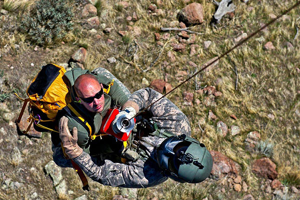
TRX Systems has been awarded a $402 million, seven-year contract by the U.S. Army for the procurement of dismounted assured positioning, navigation, and timing system generation II systems and services (DAPS GEN II).
The TRX Systems solution to be provided under the contract, TRX DAPS II, enables dismounted maneuver operations even where GPS is compromised or denied. TRX DAPS II provides assured positioning, navigation, and timing (PNT) to dismounted users by disseminating assured position and time to dependent devices in GPS-challenged environments.
TRX DAPS II fuses inputs from M-code GPS, inertial sensors, and complementary PNT sources. It is a small, lightweight PNT device that supports both standalone operation and integration with the Nett Warrior ensemble. It can also distribute PNT information to a customized tactical watch.
The TRX DAPS II solution employs a modular architecture and adheres to Army PNT interface standards, facilitating the addition of new PNT sensors as threats evolve.
TRX DAPS II will be in production for the Army later this year.
CMC Electronics has entered a multi-year contract with Sikorsky, a Lockheed Martin company, to supply its CMA-2082MC military flight management system (FMS) for several Sikorsky helicopter models, including the UH-60M, HH-60M, HH-60W, S-70i and the S-70M.
CMA-2082MC is a complete FMS with integrated radio management, which provides centralized control of navigation sensors, communication radios, mission avionics and more. It is also highly reliable while operating in harsh environments.
The helicopters complete with CMA-2082MC military FMS will be delivered to the U.S. Army and the U.S. Air Force, as well as several Black Hawk customers for use in a wide range of missions including search and rescue, troop transport, medical evacuation, disaster relief, aerial firefighting and border patrol.
Orolia’s PRSS1b PRD provides second-generation Cospas-Sarsat signaling that delivers faster and greater location accuracy than previously fielded tactical location devices.
Photo: Orolia
Cospas-Sarsat is an international, humanitarian search-and-rescue system that uses space-based technology to detect and locate model 406 emergency beacons carried by ships, aircraft or individuals venturing into remote areas, often inaccessible by mobile phone. The system consists of a network of satellites, ground stations, mission control centers (MCCs) and rescue coordination centers (RCCs) that work together when a 406 beacon is activated.
Through collaboration with the Army, Orolia produced a robust, user-friendly and highly reliable device to locate personnel who become isolated, missing, detained or captured.
Orolia conducted a demonstration in October simultaneously on multiple continents, showing its technology working with the worldwide coverage provided by the Cospas-Sarsat infrastructure. The demonstration yielded beneficial data to support the qualification of Orolia’s Personnel Recovery Device and helped inform government stakeholders on the readiness of the second-generation ground and satellite infrastructure.
A U.S. Army HH-60 Black Hawk helicopter lowers a volunteer from Central Washington Mountain Rescue via the hoist system during a training exercise.(Photo: U.S. Army)
Also in October, Orolia received Cospas-Sarsat certification for its Ultima-DT ELT emergency transmitter, designed for use on aircraft. All 406-MHz emergency beacons are digitally coded and transmit distress signals immediately upon activation on a proprietary radio wavelength.
The three main types of 406 distress beacons and the kinds of situations for which each is designed: wilderness, marine and aviation environments. (Image: Cospas-Sarsat)
A team of researchers from the University of Texas Austin (UTA) have shown the Starlink broadband constellation’s potential to serve as a backup for GPS.
Todd E. Humphreys
The researchers, led by Todd Humphreys and funded by the U.S. Army, examined the downlink signal structure of the SpaceX Starlink constellation of ultrafast broadband satellites in low-Earth-orbit (LEO), reported MIT Technology Review. The team showed that Starlink could serve as a useful backup to GPS.
For the past two years, Humphreys’ team at UT Austin’s Radionavigation Lab has been reverse-engineering signals sent from thousands of Starlink internet satellites to ground-based receivers. Humphreys told the review that regular beacon signals from the constellation, designed to help receivers connect with the satellites, could form the basis of a useful navigation system.
Title: Signal Structure of the Starlink Ku-Band Downlink
Authors: Todd E. Humphreys, Peter A. Iannucci, Zacharias Komodromos, Andrew M. Graff
Abstract: We develop a technique for blind signal identification of the Starlink downlink signal in the 10.7 to 12.7 GHz band and present a detailed picture of
the signal’s structure. Importantly, the signal characterization offered herein includes the exact values of synchronization sequences embedded in the
signal that can be exploited to produce pseudorange measurements. Such an understanding of the signal is essential to emerging efforts that seek to dual-purpose Starlink signals for positioning, navigation, and timing, despite their being designed solely for broadband internet provision.
Company prevails in military’s pursuit of CMOSS PNT solutions
Recognized for its outstanding technology achievements and the potential for impact to the United States Army and Department of Defense (DOD), Orolia Defense & Security was selected by a panel of judges as a finalist during the 2021 xTech Plugfest competition.
Hosted by PEO IEW&S, PM-PNT, the event allowed industry participants to demonstrate C5ISR/EW Modular Open Suite of Standards (CMOSS) capabilities via PNT cards, switch cards and chassis.
The event took place at the Open Innovation Laboratory (OIL) on Aberdeen Proving Grounds, Maryland, Nov. 8-19, 2021.
Photo: Orolia
CMOSS prescribes criteria for integrators that reduce the size, weight, and power (SWaP) of C5ISR and EW systems while increasing their flexibility and adaptability by enabling the sharing of hardware and software components.
Orolia submitted a CMOSS timing card and was formally recognized as a top five winner at OIL’s open house (with 200+ attendees) for demonstrating its capabilities and commitment to supporting the U.S. Army and DOD in pursuit of CMOSS PNT solutions.
“I am extremely proud of our team for their efforts and sharp-wittedness in developing and presenting this technology at an accelerated level,” said Conrad Meyer, director of business development at Orolia Defense & Security. “We are honored to have taken part in this event and to be distinguished among many contenders.”
Orolia’s prototype has a plug-and-play architecture powered by its FlexFusion engine, with additional capability for jamming and spoofing detection via its patented BroadShield software. It is designed for easy in-field upgradability.
Orolia plans this year to release a commercially available, fully compliant CMOSS/SOSA PNT card for use in military air and ground-mounted systems.
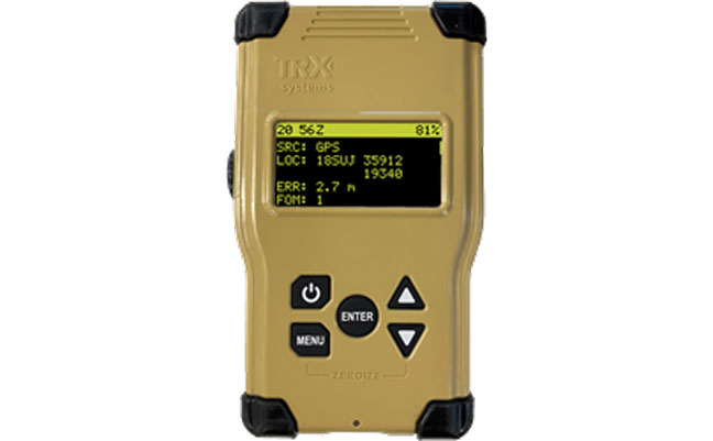
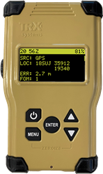
TRX Systems, developer of NEON GPS-denied location solutions, has been selected by the U.S. Army to provide a next-generation Dismounted Assured Positioning, Navigation and Timing (PNT) System (DAPS).
The TRX DAPS solution employs a lightweight soldier-worn device that enables dismounted warfighters to successfully conduct operations when operating in GPS challenged, degraded or denied environments.
Military equipment can be the subject of enemy electronic attacks, potentially resulting in a loss of location awareness that can put army missions at increased risk. The TRX DAPS solution alerts the users when their position isn’t reliable and then leverages multiple sensors and timing sources to provide the best soldier position possible within the GPS-degraded operational environment.
The solution — designed to replace the Defense Advanced GPS Receiver (DAGR) — supports both a standalone configuration and integration with the Nett Warrior ensemble. It combines inputs from small, body-worn sensors and other sources to provide assured PNT while meeting the size, weight and power (SWaP) needs of dismounted soldiers already physically burdened with heavy equipment loads.
TRX Systems has delivered GPS-denied location technology to thousands of military, public safety and security users worldwide.
“Maintaining assured PNT is paramount to the situational awareness of U.S. warfighters in the many conflict zones around the world,” said Carol Politi, president and CEO of TRX Systems. “When initial units are fielded in mid-2022, the TRX DAPS solution will deliver a balance of the highest possible level of integrated PNT capabilities with the smallest package that can be fielded for dismounted warfighters.”
Multiple leaders and technology experts from U.S. Army Futures Command are scheduled to speak at Fed Supernova 2021, an innovative defense technology conference that will take place online and at Austin’s Capital Factory Sept. 28-29.
Representatives from the command’s Army Applications Laboratory, Army Research Laboratory, Army Software Factory, Futures and Concepts Center, 75th Innovation Command and Austin-based headquarters will share insights on topics ranging from Joint Force software development initiatives to Army efforts to foster strategic industry partnerships that help bring promising new solutions to scale.
“Army Futures Command is dedicated to continuous innovation and broad collaboration. Events like Fed Supernova offer a unique opportunity for us to highlight recent wins while preparing for what’s next in the tech innovation space,” said Lt. Gen. Thomas Todd III, AFC deputy commanding general for Acquisitions and Systems and Chief Innovation Officer, who is scheduled to speak at the event.
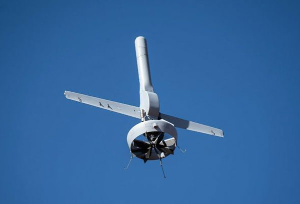
Northrop Grumman and Martin UAV (a Shield AI company) have completed successful flight testing of a V-BAT unmanned aircraft system (UAS) with new features including GPS-denied navigation and target designation capabilities.
The enhanced V-BAT’s flexible vertical take-off and landing (VTOL) capability is based on a platform deployed to address the U.S. Army’s Future Tactical Unmanned Aircraft System (FTUAS) mission. For FTUAS, the U.S. Army is seeking a rapidly deployable, GPS-denied navigation-capable, expeditionary VTOL system capable of persistent aerial reconnaissance for U.S. Army brigade combat teams, special forces, and Ranger battalions.
The offering is based on Martin’s UAV V-BAT UAS. According to Northrop Grumman, it is compact, lightweight, simple to operate, and can be set up, launched and recovered by a two-soldier team in confined environments. The V-BAT also is designed with sufficient payload capacity to carry a range of interchangeable payloads, including electro-optical/infrared (EO/IR), synthetic aperture radar (SAR), and electronic warfare (EW) payloads, depending on mission-specific requirements. Additionally, Shield AI’s recent acquisition of Martin UAV will enable rapid development of GPS-denied and autonomy capabilities for V-BAT through the future porting of Shield AI’s autonomy stack, Hivemind, onto V-BAT.
Northrop Grumman and Martin UAV conduct flight testing of Martin UAV’s V-BAT aircraft for the U.S. Army’s Future Tactical Unmanned Aircraft System effort in Camp Grafton, North Dakota. (Photo: Northrop Grumman)
The U.S. Department of Defense wants help making sense of commercially and publicly available information that could be used to detect GNSS disruptors, especially over large areas.
Obtaining the ability to detect and geolocate GNSS disruptions has been cited as an unmet need in a number of U.S. national policies and plans dealing with positioning, navigation and timing.
The recently posted solicitation calls the project “HARMONIOUS ROOK – Situational Awareness for Intentional Disruption of Global Navigation Satellite System (GNSS) Users.” The solicitation says:
“The Department of Defense (DoD) seeks commercial solutions leveraging machine-driven analytics and datasets derived from publicly/commercially available information (PAI/CAI) to provide a situational awareness capability for intentional global navigation satellite system (GNSS) disruptions. This solicitation is particularly focused on persistent, large-area coverage of falsified GNSS emitters that result in localized spoofing phenomenology.”
Studies and analyses by non-profit organizations and commercial entities have demonstrated the ability of non-governmental organizations to do this kind of work and produce remarkable results. In 2017, our Resilient Navigation and Timing Foundation detected and reported on widespread GPS spoofing in the Black Sea.
This acquisition is being led by the Defense Innovation Unit, or DIU. The unit was specifically created to accelerate the adoption of commercial technology and services by the defense and national security establishments. While letting a traditional DoD contract for a prototype can often take up to 18 months, DIU aims to award contracts within 60 to 90 days of identifying the problem.
To do this, DIU uses the government’s “commercial solutions opening” process, which is designed to be simple and quick.
Companies who provide analytic services and those who have unique data sets are both encouraged to apply. The deadline is August 23.
Dana A. Goward is president of the Resilient Navigation and Timing Foundation
An Interim Armored Vehicle “Stryker” and AH-64 Apache helicopters with Battle Group Poland move to secure an area during a lethality demonstration as part of Saber Strike 18 in June 2018. (Photo: U.S. Army/Spc. Hubert D. Delany III, 22nd Mobile Public Affairs Detachment)
“Crime is common. Logic is rare. Therefore, it is upon the logic rather than upon the crime that you should dwell.”
“Data! Data! Data!” He cried impatiently. “I can’t make bricks without clay.”
— Sherlock Holmes, “The Adventure of the Copper Beeches,” Sir Arthur Conan Doyle
Watson is to Holmes what information is to intelligence. Watson could listen to the client story, observe the situation, and recite to Holmes all the relevant facts, but he lacked the ability to string together the seemingly random pieces of information into a coherent chain of events leading to the correct hypothesis. A computer can become a Watson, but it takes a human to be Sherlock; however, a human misguided by cognitive biases will end up as Inspector Lestrade, always coming to the wrong conclusion.
When it comes to data, the analogy of drinking from a fire hose is an understatement. Consider that a digital image can be terabytes in size and every day millions of images are taken. Facebook generates 4 petabytes of data daily, and each day there are 500 million tweets and 306 billion emails. Additionally, there are 20 billion connected devices. Combined, the world creates 2.5 quintillion bytes of data every day. If a grain of sand represents a byte of data, then every three days more data is created than there are grains of sand on the Earth, and it is only increasing.
Somewhere in all that data are signals. Real-time threat intelligence systems are looking for those signals before the next huge event occurs. It is a high-stakes hunt for Leviathan, except that Leviathan is only a packet of sand traveling at lightspeed through a cloud obscured by dust.
Nellis Air Force Base takes part in Red Flag 15-2 at its Combined Operations Center in 2015. (Photo: Senior Airman Thomas Spangler/U.S. Air Force.)
Interpreting a Signal
The massive volume, variety and velocity of continuously flowing data far surpasses the ability of humans to process. It exceeds the bandwidth most systems can handle. And it quickly overwhelms the capacity to store, manage and act on the information in a timely and cost-effective manner. Resources are not infinite. The best model to handle an overwhelming amount of data is the human brain. Humans are biological sensors. Every moment of every second of our lives, our bodies are receiving an endless stream of stimuli from internal and external sources. Most of this stimuli registers at an unconscious level, and as long as the stimuli is normal and expected, it goes unnoticed by the conscious mind. If, however, any discomfort is experienced, the conscious mind is notified. Then that becomes the focus until normalized. Externally, the same applies to computer data systems. Normal conditions are ignored, but if there is something unusual, such as a loud constant noise, or a colder than normal temperature, it draws all the processing attention.
In the realm of intelligence that is basically how things function. Algorithms are written to learn the normal patterns of life and to identify specific events, words, names, etc. As long as data is within normal parameters, it gets little attention, but as soon as an anomaly exceeds a threshold or something triggers the algorithm, it will immediately be brought to the attention of the intel center. An example can be viewed on the Global Incident Map dashboard. I encourage you to sign up for a free 72-hour membership. If you want to see what real news looks like, this would be a sampling. The number of real incidents that happen across the country and around the world that you never hear about, many of them hair-raising and all of them open source, add to the few stories the media has been able to tell about cyber attacks. Scroll down the page. There are many filters, but I recommend turning them all off to see the full extent of information. Clicking on an incident will drill down into the actual source so you can read about it more thoroughly.
Below is the U.S. Army’s real-time critical incident dashboard called the Joint Analytic Real-Time Virtual Information Sharing System (JARVISS). It tracks and monitors activity near U.S. Army installations and standalone assets of interest around the world.
Another dashboard for cyberattacks is Check Point, which shows just how aggressive cyberthreats are throughout world. Here, you can see the patterns of coordinated attacks. A war is underway. The soldiers are cyberwarriors. No country is safe. View the Live Cyber Threat Map.
JARVISS is designed to target criminal activity and provide natural disaster information in and around Army installations and stand-alone facilities, as well as COVID-19 threats. (Image: Steve Gardner/U.S. Army}
Fast Analysis in Real Time
Monitoring this information, analysts look for connections. If a plane veers off its flight path, the local operations center is notified. An automatic query shows if any critical-infrastructure assets or other important structures and facilities are in the area. The analyst can immediately find out the type of aircraft, the call sign, who the plane is registered to and who filed the flight plan. Weather radar can be overlaid to see if that is a possible reason for the deviation. Incident reports can be displayed in real time within the area of interest, along with social media feeds and other sources of communication. Traffic patterns can be displayed.
The important question that needs to be answered is whether this is a potential threat. Is there a connection to anything going on anywhere else? A dossier is developed on the person who filed the flight plan, the one who is assumed to be the pilot and the person or organization to which the plane is registered. All of this is being done in a matter of minutes, while the airplane either returns to its flight path or continues its diversion. The air traffic control tower is contacted to share information on the aircraft and its deviation. If the tower does not have an answer, it will radio the pilot for an answer. The passenger and crew manifest also are analyzed. All the data that can be pulled together — including the remaining fuel burn and the aircraft performance limitations — are analyzed.
Patterns emerge from the data. These patterns lead backwards to a cause and forward toward the end result. Finding those clues in the data requires a team of specialists from six primary intelligence disciplines.
An imagery intelligence analyst brings in the live-streams and remote sensing.
A human intelligence analyst seeks motivating factors and ways to deescalate the situation.
A measurements and signatures intelligence specialist defines the operating limitations and the mechanics and science particular to the scenario.
An open-source intelligence analyst accesses and queries open-source data sets to provide clues.
A signals intelligence specialist focuses on the communications and electronic signatures.
A geospatial intelligence analyst brings it all together and provides spatial context through the map the team uses that shows the events unfold in real time.
These analysts and sometimes many others will collect all these pieces of information and turn them into intelligence that decision-makers can use to take action. That is the purpose of intelligence; as CIA veteran Richard Heuer stated, “Intelligence seeks to illuminate the unknown.”
Fortunately, most alerts turn out to be false positives, but every one of them is treated as if it were “the one.” These false positives turn out to be excellent, real-world exercises that hone the skills of the team and wire the brain for speed. These events can last mere minutes or several hours. It’s an adrenaline rush.
To explore live streaming data feeds, Esri has a growing volume of data in its ArcGIS Living Atlas.
“My mind rebels at stagnation. Give me problems, give me work, give me the most abstruse cryptogram, or the most intricate analysis, and I am in my own proper atmosphere…”
— Sherlock Holmes, “The Sign of the Four,” Sir Arthur Conan Doyle
William Tewelow works for the Federal Aviation Administration. He is a graduate of a management fellowship program. While on special assignment to the U.S. Department of Transportation William led the project to crowdsource the National Address Database for the White House Open Data Partnership. He is a Geographic Information Systems Professional (GISP) and a Maryland Scholar STEMnet Speaker. He has a degree in Geographic Information Technology and Intelligence Studies from American Military University and is currently earning a degree in Organizational Leadership. William retired from the U.S. Navy after serving 23 years as a Geospatial and Imagery Intelligence Specialist, a Naval Aviator, a Meteorologist, and a Tactical Oceanographer. He was among the first in the nation to earn a Geospatial Specialist Certification from the U.S. Department of Labor while working at NASA Stennis Space Center in Mississippi. He is married, enjoys traveling, solving problems, playing with data, and fascinated by new technology and historical context. His favorite quote is, “A man’s mind changed by a new idea can never go back to its original dimension.” ~ Oliver Wendell Holmes
The U.S. Army’s Assured Positioning, Navigation and Timing/Space Cross-Functional Team has approved the Navigation Warfare Situational Awareness Abbreviated Capability Development Document (A-CDD), signed March 25.
The A-CDD validates the operational need and enables experimentation and rapid prototyping for NAVWAR-SA capabilities for the warfighter.
NAVWAR is deliberate offensive and defensive actions to assure friendly use and prevent adversary use of positioning, navigation and timing information. NAVWAR supports Multi-Domain Operations as an enabler to precision fires, movement and maneuver, force tracking, and a host of data networks that tie personnel and weapon systems together into a joint or coalition force.
NAVWAR-SA provides the capability to detect, identify and locate sources of interference that deny or degrade reception of PNT. It is intended to validate PNT signal integrity and provide users with indication and warnings of the presence and intensity of interference.
NAVWAR-SA will also characterize the operating environment through the integration of multiple sensors that are able to detect, identify and geolocate sources of intentional and unintentional interference.
William Nelson, Director, APNT CFT
“This A-CDD will enable us to accelerate critical NAVWAR technology development and streamline the process of expediting an operationally relevant system to our warfighters,” said Willie Nelson, director for the APNT/Space CFT. “This capability will enhance our ability to provide real-time situational awareness of PNT reliability to soldiers and commanders on the battlefield, which will enable Long-Range Precision Fires and support freedom of maneuver of large scale ground combat operations.”
NAVWAR-SA will give the Army Forces the ability to “sense” the PNT environment in real-time, allowing commanders and units to maneuver with confidence and with precision when the global positioning system is degraded or denied. This is critical element of NAVWAR operations.
The APNT CFT coordinated with organizations across the modernization enterprise to get the NAVWAR-SA A-CDD approved. The Army Capability managers for Space and High Altitude played a major role in developing the written requirement and getting it through the approval process.
“The requirements provided in the NAVWAR-SA A-CDD are a first step in developing dedicated NAVWAR capabilities for our soldiers and are a key enabler in enhancing lethality in combat operations,” said Col. Tim Dalton, Army Capability manager for Space and High Altitude director.
The A-CDD details methods to leverage new and existing solutions for rapid prototyping, testing and soldier assessment. The APNT/Space CFT will utilize the “buy, try and decide” process to accelerate the development of critical enabling technologies and streamline the process of transitioning a scalable, interoperable and agile capability to the field. This process will inform NAVWAR-SA requirements for current and future Army systems.
“NAVWAR-SA will strengthen the Army’s ability to conduct military operations in PNT-challenged environments,” said David Pinckley, NAVWAR director for the APNT/Space CFT and chairman of the NATO NAVWAR Capabilities Team. “The unfortunate reality is that our systems will continue to be challenged by our adversaries so we are working with our joint and coalition partners to preserve military capabilities while mitigating impacts of interference.”
NAVWAR is one of the three APNT/Space CFT Signature Efforts, which will deliver offensive and defensive NAVWAR capabilities in conjunction with existing Department of Defense NAVWAR policies.
Joint and coalition forces conducting military operations will employ NAVWAR-SA to coordinate and implement mitigating actions to overcome PNT challenged environments.
The APNT/Space CFT plans to assess and test NAVWAR-SA prototypes later this year, during Project Convergence 21 and the CFT’s annual PNT Assessment Exercise at the White Sands Missile Range, New Mexico.
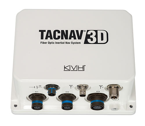
KVH has been developing and testing the PIC technology for more than three years and is continuing to roll the technology into existing product lines.
KVH’s PIC technology features an integrated planar optical chip that replaces individual fiber optic components to simplify production while maintaining or improving accuracy and performance. KVH’s IMUs with PIC technology are designed to deliver improved bias stability and 20 times higher accuracy than other micro-electromechanical systems (MEMS) IMUs.
The fiber-optic gyro (FOG)-based TACNAV 3D tactical navigation system provides an assured positioning, navigation and timing (A-PNT) solution with an embedded GNSS and optional chip-scale atomic clock (CSAC). TACNAV 3D’s modular tactical design enables it to function as a standalone inertial navigation solution and as the core of an A-PNT-capable multi-functional battlefield management system.
“We are pleased to incorporate our newest technology into the TACNAV 3D,” said Dan Conway, executive vice president of KVH’s inertial navigation group. “We are committed to ensuring that this battle-proven system provides the precise navigation that is vital to mission success and addresses the military demand for assured positioning, navigation, and timing (A-PNT) solutions.”
KVH’s TACNAV solutions are being used in vehicles that operate in demanding environments, from battle tanks and M-ATVs, to armored vehicles, reconnaissance and combat support vehicles.
Defense forces using TACNAV systems include the U.S. Army and Marine Corps, as well as many allied customers including Australia, Botswana, Brazil, Canada, Egypt, France, Germany, Great Britain, Italy, Malaysia, New Zealand, Poland, Romania, Saudi Arabia, Singapore, South Korea, Spain, Sweden, Switzerland, Taiwan and Turkey.