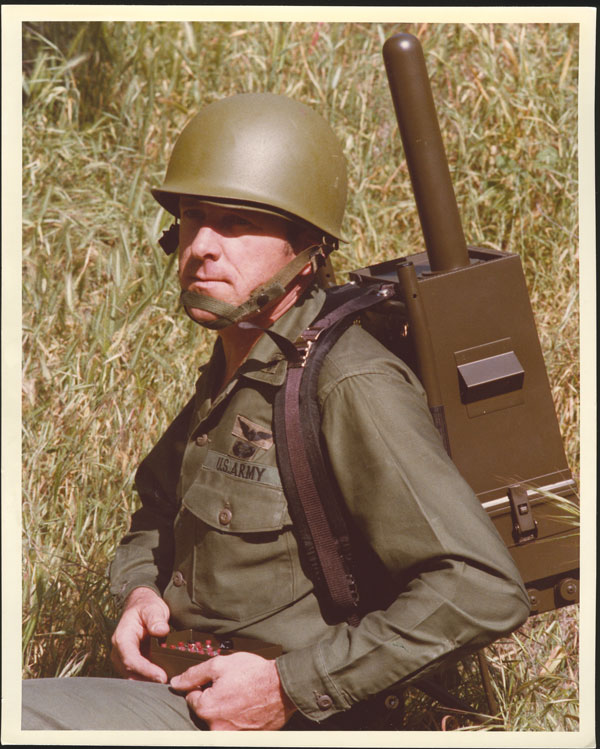
Developed for a U.S. Army Program of Record, the TRX DAPS GEN II solution provides warfighters with a resilient, trusted source of position, navigation and timing (PNT) that remains operational in GPS-degraded, jammed or denied environments.
The new enhancements strengthen DAPS GEN II system performance in extended-duration threat environments and include a new mounted capability that facilitates vehicle integration.
The new mounted capability delivers a modular, open architecture that expands client support and provides future extensibility while leveraging the core DAPS GEN II capability. To facilitate use of DAPS GEN II in vehicles, a vehicle interface adapter (VIA) is under development to provide the following capabilities:
Hold the DAPS GEN II device securely in the vehicle, enabling improved inertial performance under threat
Accept and condition power from the vehicle, extending battery life
Extend the number of supported clients, enabling vehicle systems to consume a single assured-PNT feed
Provide RF and data interfaces to anti-jam antennas, enabling tight integration with the antennas, including sharing of electronic warfare situational awareness information
Provide a FLEX-IO port, enabling extensibility by supporting addition of new PNT sensors and simplifying transition of new assured PNT capabilities
JNC 2026 attendees can visit the TRX team in Booth #319 to learn how the DAPS GEN II solution supports dismounted and mounted operations by delivering continuous, assured PNT – even in contested environments.
During the conference, TRX leaders will participate in technical sessions where they will discuss the latest DAPS GEN II innovations and share testing results for delivering assured PNT in both dismounted and mounted situations:
Session C6 (Tuesday, 11:30 a.m.): Speakers from TRX Systems and Combat Ready PNT will present U.S. Army Program of Record: DAPS Gen II Advancements, Interoperability, and Performance. This presentation will review DAPS GEN II innovations that increase resilience to extended-duration threats.
Session C6: TRX Systems is supporting an alternate presentation,U.S. Army Program of Record DAPS Mounted ECP (DME). This presentation will cover the functionality being developed with the VIA and provide results from the development and testing.
Modernized GPS is strengthening operational assurance and signaling a new era of assured positioning, navigation and timing (PNT) for U.S. and allied forces
L3 Harris has reached a milestone with the delivery of the 100,000th next-generation military-code (M-code) GPS receiver to the United States and allied partners through the Modernized GPS User Equipment (MGUE) Increment 1 program.
M-code receivers are designed to deliver secure, jam-resistant PNT capabilities that are essential as military operations grow more distributed, joint and technologically complex. Unlike legacy systems, M-code-enabled receivers provide enhanced security features and increased resistance to interference, allowing forces to maintain trusted GPS access when signals may otherwise be degraded or denied.
“As the global threat environment continues to evolve, secure and resilient PNT has never been more critical to ensuring operational advantage,” said Quinlan Lyte, president, Advanced Effects, Missile Solutions, L3Harris. “Reaching this delivery milestone reflects our team’s sustained commitment to equipping the warfighter with reliable technology designed to perform in the most contested environments.”
Beyond the milestone itself, the scale of fielded MGUE Increment 1 receivers underscores a broader shift toward modernized, mission-ready GPS capability across U.S. and allied platforms. From air and ground systems to maritime and joint operations, M-code technology is helping commanders operate with greater confidence in environments where GPS reliability can no longer be assumed.
Onto the next phase
L3Harris is building on the momentum from MGUE Increment 1 as the company advances the next phase of GPS modernization through MGUE Increment 2. Ongoing development includes a new M-code-enabled application-specific integrated circuit and the TruTrak-M Type II receiver, technologies designed to further improve size, weight, power and cost efficiencies while maintaining robust security and performance. These advancements will enable greater integration and flexibility, as well as broader adoption across future platforms.
Successful deployment at APEX validates the technology as a crucial inertial-sensor stack for assured PNT on the modern battlefield.
Advanced Navigation successfully demonstrated in April 2025 its inertial-centric intelligent navigation as part of the U.S. Army’s All-Domain Persistent Experiment (APEX), underscoring the ability to deliver reliable, high-accuracy navigation in GNSS-degraded and -denied conditions.
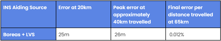
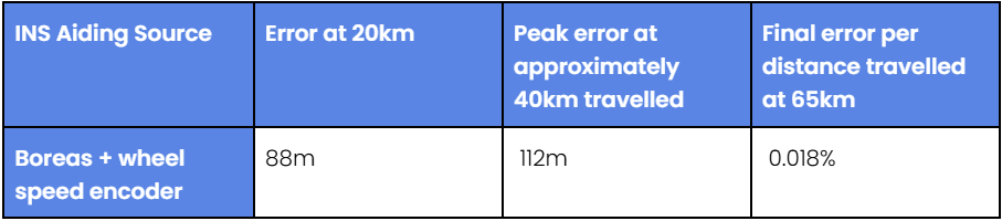
Designed for the DDIL (Degraded, Denied, Intermittent and Low-bandwidth), APEX provided Advanced Navigation with an operationally relevant testbed to evaluate the performance of its Boreas D90 fiber-optic gyroscope (FOG) inertial navigation system (INS) when fused with complementary aiding sensors, including the laser velocity sensor (LVS) and a wheel-speed encoder. The results reaffirm Advanced Navigation’s intelligent software-defined approach as a resilient foundation for APNT on the modern battlefield.
“Assured PNT is non-negotiable. The only path to operational advantage is an intelligent, multi-sensor fusion anchored by a resilient inertial core. We deliver this with our sophisticated AdNav Intelligence software,” said Chris Shaw, Advanced Navigation CEO. “Now in our third year participating in this U.S. Army program, APEX continues to challenge our systems under realistic electronic warfare conditions.”
Boreas D90. At the center of the architecture is the Boreas D90, a strategic-grade FOG INS that serves as the “nervous system” of the navigation stack. Unlike conventional systems reliant on GNSS or magnetic compasses, Boreas D90 determines true North through gyrocompassing, using ultra-sensitive fiber-optic gyroscopes to detect the Earth’s rotation. This enables independent, high-confidence navigation, even when external GNSS signals are compromised.
AdNav Intelligence. AdNav Intelligence software continuously validates all sensor inputs, adjusts in real-time to the operational environment, and autonomously counteracts spoofing and jamming. The sophisticated software can adapt in real time to respond to incoming threats, dynamically weighing the input from each sensor to make real-time adjustments on which sensor to rely on based on their reliability scores, environmental conditions, and operational context.
Demonstration setup
During APEX, Boreas D90 with AdNav Intelligence was integrated with both a laser velocity sensor and a wheel-speed encoder aboard a four-wheel-drive vehicle. The demonstration was conducted during night operations at a site in rural New Mexico, under a created environment of complex and emerging electronic warfare threats with GNSS jamming.
The Boreas D90 was fused with Advanced Navigation’s advanced infrared laser sensor that measures ground-relative 3D velocity with exceptional precision. LVS performs reliably on both ground and airborne platforms regardless of environmental conditions or the availability of visual references, as long as it maintains a clear line of sight to the ground or a stationary surface. By providing direct, drift-free velocity measurements, the LVS ensures continuous, high-precision mobility and enhances navigation resilience even in the most extreme contested GNSS environments.
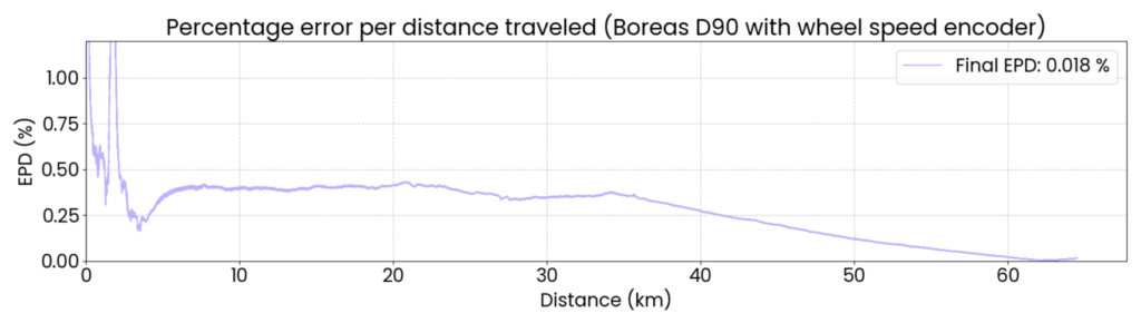
This configuration demonstrated dead-reckoning accuracy, achieving a 0.012% error per distance traveled (7.5 m over 65 km) in the same contested conditions.
Wheel-speed encoder. Wheel-speed encoders offer a rugged and cost-effective source of motion data, measuring wheel rotation to determine ground speed and distance traveled. Their design ensures quick integration across tactical platforms. Ideal for firm terrain and structured routes, they provide dependable dead-reckoning performance when GNSS is denied, making them a practical choice for missions that demand reliability over complexity.
When paired with a wheel-speed encoder, the Boreas D90 delivered reliable dead-reckoning performance useful for platforms operating in predictable or structured environments. Across the demonstration, the Boreas D90–wheel-encoder configuration maintained strong navigation continuity, achieving a 0.018% error per distance traveled (11.7 m over 65 km), without reliance on GNSS, even under deliberate jamming.
Next Steps for APNT
For Advanced Navigation, the results from APEX show significant potential for a range of current and future defense applications. The technologies exceeded the team’s expectations, demonstrating the level of accuracy and operational reliability required for successful navigation under GNSS-denied and -degraded conditions.
Integrating INS with next-generation photonics promises to further advance capability, resilience and adaptability on the battlefield, Advanced Navigation said.
About the U.S. Army’s APEXevent
Previously known as the Positioning, Navigation, and Timing Assessment Experiment (PNTAX), the sixth annual APEX event was held at the U.S. Army’s premier military test range, designed to replicate the complex, contested conditions that forces are expected to face in future multi-domain operations.
The next experiment will include partners within the United States Air Force’s 746th Test Squadron and the Joint Navigation Warfare Center, U.S. Army Combat Capabilities Development Command, and the Army Test and Evaluation Command. Advanced Navigation expects to take part 2026.
APEX provides a rigorous environment for evaluating mission resilience across a broader spectrum of technologies. While resilient PNT remains a core component, the event extends to integrated sensing capabilities, advanced communications architectures, data transport, and edge processing. These systems are evaluated under threat-informed, operationally realistic scenarios that reflect the evolving demands placed on modern military platforms in GPS-degraded or -denied environments.
The latest generation of Safe Pro’s AI technology will be presented at U.S. Army exercise at Fort Hood, Texas
Safe Pro Group, a developer of artificial intelligence (AI)-enabled defense and security solutions, has deployed upgraded AI algorithms to its patented Safe Pro Object Threat Detection (SPOTD) technology for drone operations in GPS-denied environments.
The newly enhanced SPOTD capabilities will be prominently featured at the upcoming U.S. Army 2026 Concept Focused Warfighter Experiment (CFWE) technology demonstration taking place at Fort Hood, Texas.
Operating on the Amazon Web Services (AWS) Cloud or at the Edge, SPOTD is Safe Pro’s patented rapid battlefield image analysis platform designed to identify and map small explosive threats such as landmines and ambush drones detected in videos collected from virtually any drone.
The ability for SPOTD to rapidly detect threats and create 2D/3D models from drones flying in GPS-denied environments was developed after real-world exercises in Ukraine at the request of end users. The integration of these new algorithms further enhances the value of SPOTD as a situational awareness tool for use in a wide array of military reconnaissance and planning operations.
SPOTD enhancements include:
Ability to process any drone video data: Turning video clips into 2D and 3D models with AI-trained explosive threat detections
Enhanced operational robustness: Operating capability in GPS and GPS/GNSS denied environments
Terrain modeling: Threat and terrain mapping in support of unmanned ground vehicles (UGVs) route planning
Rapid mapping-only mode: Mapping for intelligence, surveillance and reconnaissance (ISR) and missions that do not require AI-powered threat detections
Accelerated processing: Up to 10x reduction in processing time powered by Safe Pro’s proprietary geospatial AI algorithms.
Powering the company’s SPOTD technology is Safe Pro’s unique real-world datasets, which include high-resolution drone imagery and GPS-tagged geospatial data encompassing more than 2.2 million drone images analyzed to date, and 41,400+ threats identified across 11,400 hectares (28,000+ acres).
The U.S. Army is starting market research for possible sources of an optical tracking solution for its test ranges to use in GNSS-denied environments.
The Army Contracting Command – Orlando issued a Sources Sought Notice Dec. 11 on behalf of the Test Resource Management Center Test and Evaluation/Science and Technology (T&E/S&T) Program.
The Army wants to identify potential sources in the market having the interest, skills and ability to complete a thorough technology study and trade space analysis related to the viability of Time-Space-Position Optical Tracking (T-SPOT) for use on test ranges. The technology would be used as a time-space-position information (TSPI) truth sensor in GNSS-denied environments.
Required capabilities
The primary objective of a T-SPOT prototype effort would be to develop the system architecture, concept of operations, and comprehensive trade space analysis based on the results of modeling and simulation of the future-state system. The intent of the effort would not be to deliver the fieldable system itself but rather to answer whether/how such a system would achieve its performance goals.
A future T-SPOT system should
achieve 3D TSPI accuracy comparable to the accuracy of real-time kinematic positioning (RTK) GNSS navigation systems.
be generated in a near-continuous manner, notionally at an update rate comparable to GNSS navigation systems.
achieve full performance during daylight and in good visibility conditions, with the goal of operating at day and at night and in all-weather conditions.
support temporary and modular integration with airborne systems being tested, operating at altitudes typical for the operation of U.S. Air Force cargo and single-engine training aircraft, with the goal of supporting aircraft closer to or on the ground.
minimize its size, weight and power (SWaP) budget for integration with crewed aircraft, with the goal of supporting integration with small uncrewed aerial systems.
In addition to the sensor hardware hosted on the SUT, a future T-SPOT system should rely on terrestrial features solely comprised of passive landmarks (no active emissions; no required power). The system may employ synthetic landmarks (e.g., purposely installed fiducials) and/or pre-existing landmarks (of either natural or human origin). While the system must operate independently of GNSS, GNSS may be used pre- and post-test (i.e., for landmark surveying).
More details are on the announcement page. The deadline for responses is Jan. 30.
Locus Lock, a leader in software-defined GNSS technology for precise position, navigation and timing (PNT) solutions, has teamed up with General Dynamics Mission Systems to deliver software-defined precise PNT capabilities for the U.S. Army.
General Dynamics Mission Systems, a provider of mission-critical solutions to defense, intelligence, and cyber-security customers across all domains, brings extensive expertise in mission-critical systems integration to ensure seamless deployment across Army platforms.
Locus Lock’s software-defined GNSS technology enables rapid deployment and procurement of advanced multi-frequency, multi-constellation GNSS capabilities, providing essential signal diversity in contested radiofrequency (RF) environments to advance the Army’s modernization objectives.
The collaboration with Locus Lock and General Dynamics enhances the resilience, precision and reliability of Army navigation systems operating in complex and contested environments.
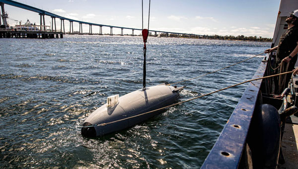
The U.S. Department of Defense (DOD) has spooled up to take the lead in drone warfare with its Replicator 1 program initiative. Securing $500 million in funding in 2023 for “attributable UAVs, DOD is planning another half of a million dollars for the Replicator 2 program. The Replicator initiatives are intended to bring on large volumes of potentially existing capability through increased manufacturing and technological capability. AeroVironment received Rep 1 funding for Switchblade-600 kamikaze drones, which had previously been used successfully in Ukraine, and various initiatives are also underway with many U.S. manufacturers of unmanned surface vessels (USVs), including Anduril’s Dive-LD autonomous underwater vehicles.
Anduril Dive-LD unmanned undersea vehicle. (U.S. Navy photo by Ian Delossantos)
Having launched contracts increasing the available volume of attack UAVs (loitering munitions), it has been decided that the Replicator 2 program will go after the protection of U.S. forces from enemy drone attacks. Both sides in Ukraine have built up their UAV attack capability, and as a consequence, both sides now need better defenses against offensive UAV threats. DoD has also learned from experience in the Middle East, where its naval assets have suffered from kamikaze UAV attacks in the Gulf.
Inexpensive, commercially available UAVs loaded with explosives and remote control and proximity detonators have proved effective weapons. The next phase of Replicator will seek funding in 2026 for counter small-unmanned aerial system (C-sUAS) initiatives, building up existing capability and technology and developing improved defense capabilities.
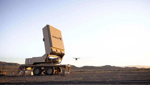
Several c-UAS systems have been developed and fielded in recent years, but DOD’s efforts on Directed Energy Weapons are being intensified. High power microwave (HPM) systems can be used to jam UAV communications and disrupt onboard drone electronics such as navigation, guidance, sensors and control systems. Its only drawback is that effectiveness diminishes rapidly with the range from the HPW transmitting antenna. This is due to the increased dissipation of microwave energy in the air with the square of the distance traveled – straight physics. Nevertheless, if you can pump enough power out of the transmitting antenna, say in a narrower beam, you may still be able to cover enough distance to disable an attacking swarm of adversary UAVs, even if it ends up being close in as the UAVs approach the target.
Based in Los Angeles, Epirus recently delivered its Leonidas Expeditionary HPM system under a U.S. Navy contract. The system is mounted on a towed trailer, with the HPM antenna mounted on a turntable to enable directional aiming for a more dynamic ground-based defense against drones. Previous testing has demonstrated the system’s capability to “fry” single and multiple UAVs.
A U.S. Army 2023 contract allowed Epirus to prototype four of the Leonidas systems, which have been delivered to the agency and are potentially slated to find active service in the Middle East. This real-world test aims to shake down the systems under high-stress defensive situations, providing feedback for future improvements if required. The situation on the ground clearly demands improved defensive capability.
Earlier tests of high-power laser defenses in the region allegedly encountered some difficulty with durability and heat dissipation for 50Kw vehicle-mounted systems, while 20Kw laser systems performed better.
It would seem that the high-intensity microwave beams used by the Leonidas systems might be more usable by ground forces. Epirus has reported that a unique approach to power management was one of the initial core elements developed for the Leonidas system, which may affect the ability to form high-power microwave beams.
Earlier defensive approaches have included rifle fire, shoulder-mounted missiles, expensive guided missile defenses, anti-drone drones that collide or throw nets, jamming of the control signals, and, of course, GNSS jamming and/or spoofing. HPM “frying” of multiple drones at a time may be another key defensive approach that may make drone attacks harder for adversaries to inflict on our forces on the battlefield.
So, the next phase of this game could be to develop counter-counter-drone technologies to defeat the defensive systems—this may be a never-ending process.
The U.S. Army has awarded Lockheed Martin and Northrop Grumman other transaction agreements (OATs) for the first phase of the Launched Effects (LE) program.
Launched Effects “will provide standoff sense and effect capabilities for soldiers while keeping air and ground forces outside the range of adversary weapon systems,” according to the service’s Program Executive Office for Intelligence, Electronic Warfare and Sensors. It also said LE will also support forces entering and exiting mission areas.
Northrop has been awarded for two payloads and Lockheed Martin has been awarded for one, with each award valued at about $100,000, according to the Army. The OTA will total about $37 million over all three phases.
The LE program consists of three phases. During that span, the Army aims to mature payloads from a technology readiness level of 6, a prototype system that has been tested in a relevant environment, to TRL 7, a prototype that has been demonstrated in an operational environment.
Launched effects have been successfully tested by the Army in the past, including at Project Convergence. In January 2023, General Atomics Aeronautical Systems announced its Eaglet launched-effect flew for the first time, dropping off an Army-owned Gray Eagle Extended Range UAV during a demonstration in Utah.
The Air Force was initially opposed to GPS. How did that change?
Between 1978 and at least the mid-1980s, maybe even the late 1980s, the Air Force tried several times to cancel the program. At the time, I was a Capitol Hill staffer for the House Intelligence Committee. In one of those efforts to cancel GPS, Tom Cooper, who was a lead staffer for the House Armed Services Committee, came to me and said, “Can you guys give any reason for keeping GPS?” And I said, “Yes, it greatly improves the accuracy of SIGINT [signals intelligence] locations. It makes a very big difference.”
So, Tom used that, along with other arguments, for why we should keep GPS. The Committee and Congress ultimately decided they would, despite the Air Force’s resistance.
The Air Force’s resistance came from the Strategic Air Command, which in the 1980s believed it would never use satellites. They were concerned about the satellites being shot down. I found this amusing because they were flying around in aircraft at a few thousand feet and were concerned about satellites flying at 11,000 miles. But they were, so they were laggards.
Image: USAF/Staff Sgt. Kyle Johnson
Which service adopted GPS first and why?
The service that by far led the way was the Army. It spent $100 million a year absorbing NRO capabilities. They also spent money on GPS, though not as much. By the time we got to the first Gulf War, in 1991, we had a partial GPS constellation — I think of 18 satellites of the 24 required — and that meant that you didn’t have 100% coverage all day long. So, coverage maps of their areas of interest were generated every day to let people in the field know when they would have service. Most of them didn’t have receivers either. Most of the receivers they did have were Precision Lightweight GPS Receivers (PLGR), knows as “pluggers”, which were the first “handheld” receivers, but they were pretty big.
Once the fight got going, many of the troops wrote home and asked their moms and dads to send them civilian receivers.
Yes! Thousands and thousands of them showed up in theater. Some troops taped them to the windscreens of their helicopters or jet aircraft. They were just jury-rigged into everything because, despite their limitations at the time, they were very, very useful, unlike anything else. So, now everybody realized, “Oh my goodness, this is really a big deal. This is a game changer!”
Then we got more modern receivers, integrated receivers, the whole thing. However, at the end of the Gulf War, the Air Force still had no plan to equip any of its aircraft with GPS. As Assistant Secretary of the Air Force, I was called over to the Armed Services Committee and asked, “What is your plan for integrating GPS receivers into your aircraft fleet?” I said, “There is no plan.” and they were incredulous. They looked at me like “Well, you’re an idiot.”
It wasn’t me, however, and the staff knew my story before I gave it. As a result, Congress mandated it. They put it in that year’s National Defense Authorization Act (NDAA). Within less than 10 years you had Joint Direct Attack Munitions (JDAM) and other GPS-guided weapons. So, that got it moving quickly.
By the end of the 1990s, the Air Force was fully on board and were equipping their aircraft with many weapons that depended on GPS. Meanwhile, GPS had moved to a full constellation of 24 satellites. Full operating capability was declared in 1995. The Navy proceeded similarly, but they were somewhat less affected. So, the Army remained a leader in using space.
The Chief of Staff of the Air Force asked me about Air Force use of GPS. I said, “Chief, the Air Force builds a lot of space stuff, but it doesn’t use it.” Of course, a short time later it was using it extensively. So, this ramp-up was very rapid — just a few years from “I don’t give a darn about these things” to “I can’t live without them.”
Brad Parkinson and his successors as JPO directors designed and built the system but had no role in its adoption, right?
No. They were going turn it over to the production house, if you will, and they did. Once the Air Force got on board with GPS guided weapons, adoption proceeded rapidly.
What about the Navy?
I don’t recall the Navy particularly. I do not at all accuse them of being laggards. I think they did what they needed, whatever that was.
Did later NDAAs expand that mandate to the other services?
I don’t know. I was out of the government by that time, so I lost track. I don’t think it was necessary. What people didn’t understand immediately was that you could do anything with this system. At the end of the day, it is a super accurate timing signal. There are many things you could do with that and people have done them. It quickly became evident that it was so pervasively useful, that anything you could think of involves GPS, from the era of the first Gulf War onward. By 10 years later, many weapons systems in all the services were GPS-guided. I later served on the board of ATK and we were building GPS-guided artillery rounds. I am pretty sure that the ATACMS [Army Tactical Missile System] you hear about today is GPS guided.
So, in a couple of years, all the services wanted to integrate GPS in all their platforms and weapons.
Well, except that the amazing thing was, despite all the things that people had done with GPS in the Gulf War — starting with those helicopters that went in the first night and took out the command and control system, which were guided by Army-provided pluggers taped onto the windscreens by their pilots, and downed pilots using GPS to give their coordinates to the rescue teams — at the end of the war the Air Force still didn’t have a plan to put them on its aircraft! That’s when Congress mandated it. It was amazing.
Despite that, once they got going, particularly once they got going with GPS-guided weapons, everything changed. I don’t know whether the Air Force became leaders, but they were certainly aggressive integrators of the program into the service. There was no more, “We won’t use satellites” and all that.
That was after my time. I left government in early 1993. There were other big fish to fry at the same time. As important as I realized it was, I still didn’t realize how important it was, and I was way ahead of most everybody else, in the Air Force anyway.
The Federal Aviation Administration’s (FAA’s) chief scientist at the time said, “The great thing about GPS is that it is a tool around which you can build myriad capabilities.” He outlined a few for the FAA, many of which they have since done. The same thing began to happen in the services, particularly in the Air Force, in which GPS-guided weapons were pervasive within 10 years.
Part of Brad’s motto for JPO was “The mission of this program office is, number one, to drop five bombs in the same hole.”
Yeah. By the way, one mistake that people make a lot is they think there were GPS-guided weapons during the first Gulf War. That was not the case. There were none by then. There were precision guided munitions that were guided by maps and lasers and a variety of means. But, despite the belief of many authors, there were no GPS-guided weapons at that time.
So, which was the first conflict in which GPS was used?
It was the Iraq War, in 2003. It was a major user of GPS-guided weapons.
Any other thoughts on the 50th anniversary from the military side of things?
It is impossible to overemphasize the importance to military operations and, frankly, to civilian life as well, of being able to easily and accurately navigate or have highly accurate time.
You can do it with a $100 receiver, whereas it used to require a $10,000 receiver and you had to have it re-initialized from a standard. So that’s what everybody does. Now, this has created probably more dependency than is healthy and many nations have backup that we don’t have.
Such as Loran-C. That’s a big subject of debate these days, as you know.
Well, it’s been a subject of debate for 20 years. Everybody agrees, but nobody moves.
The Department of Transportation recently released an action plan on the adoption of complementary PNT systems. So, there’s some movement.
As a one-time government bureaucrat, what you do when people are on your back is launch a study and say, “Well, it will be done in a year or two.” They have done this time, after time, after time.
“I know where we are. I do not need a satellite system to tell me!” In the 1970s and 1980s, this was the number one military and civilian response to what GPS does. The existing military hardware included navigation systems and the defense industry had a vested interest in keeping its business. Civilian interest in GPS was low because of the program’s uncertain funding. The armed services saw no reason to add a new program to their budgets and were opposed to GPS.
The military program approval process was also inconsistent with the rapid changes in digital technology. The first GPS satellite was launched in February 1978, the first PC was released in August 1981, and the first Mac in January 1984. GPS went through a development process to build user equipment, test it to make sure it met military requirements and then build the limited-rate production equipment with a design about six years old.
Early GPS Manipack worn by JPO Army deputy Lt. Col. Paul Weber. This photo graced the cover of the first ever GPS brochure. (Image: GPS World archives)
My favorite joint service story is that our low cost, 19-lb, $55,000, hand-carry man pack flunked its first testing sequence. The Army placed it into an alkaline bath in September 1985, that ate the o-ring and caused it to fail the bio/chem decontamination requirement. The o-ring was an Air Force requirement because at 60,000 ft without venting the device would become a potential bomb. Yet, pressure relief failed to meet the Navy Seals’ requirement for underwater operation. The fixed man pack was now our limited rate production set. Developments in digital technology during the process made it overweight, over cost and unsuitable. To get hand-carry receivers, it became necessary to purchase modern civilian sets at the unexpected outbreak of the First Gulf War in 1990.
JPO ran a competition for 200 civilian receivers that had no military requirements to send them to the operational forces for training. Trimble won the competition and when the war came the following year with only 12 GPS satellites operational, JPO asked Trimble to deliver as many sets as it could produce at the price bid for the competition to augment the deliveries of the limited rate production military set. Talk about an operational education! The Army tank drivers who did not want GPS because “The war comes to us, so we do not need GPS” instantly demanded GPS receivers when they began to get lost by more than 10 miles on the featureless desert. The deployed troops began asking their parents for GPS receivers for personal use. The war integrated GPS into all military operations.
Realizing the value of GPS inter-service integration of forces, the military believed the civilian signal should only have degraded accuracy. But in May 2000, President Clinton decided the civilians also should have good accuracy and ordered that the degradation of the civilian signal (called Selective Availability) should cease. Today everybody is aware of what GPS provides. You never hear anyone say, “I know where I am, I do not need satellites to tell me.”
Inertial Labs has been awarded an SBIR Phase III contract by the Army Applications Laboratory of Army Futures Command. This award supports Inertial Labs development, design and fabrication of the Cannon Artillery Pointing and Sighting System (CAPSS) for potential use on the U.S. Army’s Paladin and the extended range cannon artillery (ERCA) vehicles.
The CAPSS aims to dramatically reduce weight on the target vehicle platforms by providing a digital replacement for the vehicle’s current panoramic telescope (PANTEL). The PANTEL is used as a sighting system for the gun when the fire control system is inoperable. The CAPSS prototype is being designed to physically replace the PANTEL.
CAPSS is a collection of cameras, inertial measurement units (IMUs), advanced electronics and an intuitive tablet-based user interface. Designed to digitally mirror the PANTEL, the CAPSS system allows soldiers to emulate all PANTEL functions via the tablet, bypassing the need to physically manage the telescope.
More than 400 lbs in equipment weight is eliminated by replacing the current equipment with CAPSS, which improves the vehicle’s operational efficiency. Additionally, the features integrated within CAPSS eliminate the need for warfighters to leave the vehicle cabin for typical aiming and sighting activities connected to the PANTEL setup, such as working with the auto-collimator. All of the functionalities are inherently embedded in the CAPSS, which simplifies operations.
The CAPSS camera technology is also used for semi-automated ranging capabilities. Warfighters can effortlessly zoom in on specific objects, offer estimated data based on the object’s attributes, such as size estimation, and the system will generate the estimated range to that particular object.
Looking ahead, Inertial Labs plans to continue research on optical/inertial-based GPS-denied navigation designed for land vehicles, integrating both camera systems and inertial sensor data.
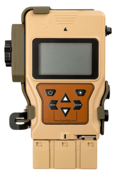
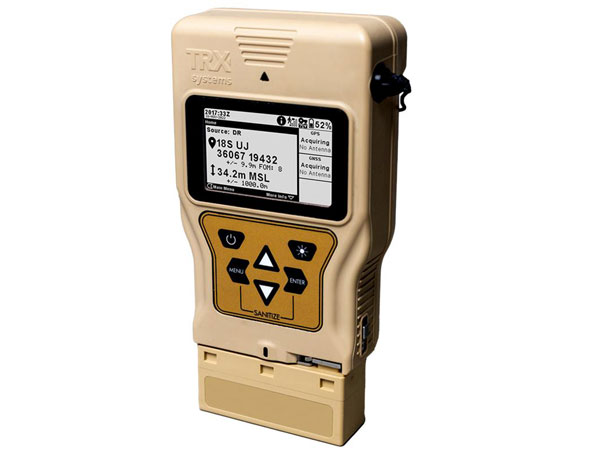
TRX Systems has announced it is now shipping the Dismounted Assured Positioning, Navigation, and Timing (PNT) System Generation II (DAPS GEN II) solution to the United States Army. The device provides assured PNT to warfighters operating in GPS-denied environments.
In March, the U.S. Army Program Executive Office for Intelligence, Electronic Warfare and Sensors awarded TRX a seven-year, $402 million contract to deliver the DAPS GEN II systems.
TRX DAPS GEN II is a small, handheld device that features efficient power utilization algorithms that enable a continuous stream of assured PNT data for warfighters and their combat systems. To achieve this, the device fuses inputs from a diverse range of PNT sources including M-code GPS, a secure and higher-powered military GPS capability that is resilient against jamming and other threats, complementary sources of position and time data when GPS is degraded, and inertial sensors supporting integrity and positioning, independent of any satellite source.
The TRX DAPS II system is available for purchase by U.S. government entities. Distribution to U.S. allies is restricted to approved cases in the Foreign Military Sales Program.