Per Enge, Professor and Director, Stanford university Center for Position Navigation and Time
Satelles, a secure time and location solutions company, has appointed Per Enge to its board of directors. Satelles provides a time and location solutions delivered over the Iridium constellation of 66 low-earth-orbiting satellites.
Enge is the Vance and Arlene Coffman Professor of Aeronautics and Astronautics for Stanford University, where he is also the director of the Stanford Center for Position Navigation and Time.
“I am eager to join the Satelles Board of Directors and look forward to supporting the management team,” Enge said. “I am encouraged by the progress Satelles has made and continue to have confidence in the leadership team and future growth of the business.”
Enge’s laboratory has worked with the U.S. Coast Guard to design a medium frequency radio system to broadcast differential GPS corrections to maritime users, and this system has been implemented as a worldwide standard.
His laboratory also worked with the U.S. Federal Aviation Administration to develop WAAS, the Wide-Area Augmentation System that provides GPS integrity data to airborne users. Today, WAAS is carried by more than 100,000 aircraft, and similar systems have been implemented in Europe, India and Japan.
Enge also serves on the board of directors of Amida Technologies, and he serves as a technical advisor to Polaris Wireless.
He has received the Kepler, Thurlow and Burka Awards from the Institute of Navigation for his work. He is a Fellow of the Institute of Electrical and Electronics Engineers. He is a member of the National Academy of Engineering and a fellow of the Institute of Navigation.
Enge received his Ph.D. in electrical engineering from the University of Illinois in 1983. In 2012, the U.S. Air Force inducted Enge into the GPS Hall of Fame.
“It is with great pleasure that we welcome Per to Satelles Board of Directors,” said Michael O’Connor, Satelles CEO. “Per has distinguished himself as a technology innovator and brings to our board of directors deep expertise in global navigation satellite systems. His wealth of experience and expertise in GPS and other technologies adds new depth to our board as we continue to deliver Satellite Time and Location to users around the world. We look forward to working with Per on our mission is to deliver trusted time and location solutions that augment and enhance existing solutions — including GPS.”
The change provides a secure, encrypted connection between browsers or other tools connecting to the Navigation Center website. It also provides authentication that you are unquestionably connecting to the Navigation Center website.
This change is a result of Office of Management and Budget (OMB) Memorandum M-15-13, Policy to Require Secure Connections across Federal Websites and Web Services, which requires that all publicly accessible federal websites and web services only provide service through a secure connection (HTTPS instead of HTTP).
Address any questions to the Navigation Center’s Web Services team via the Contact Us page.
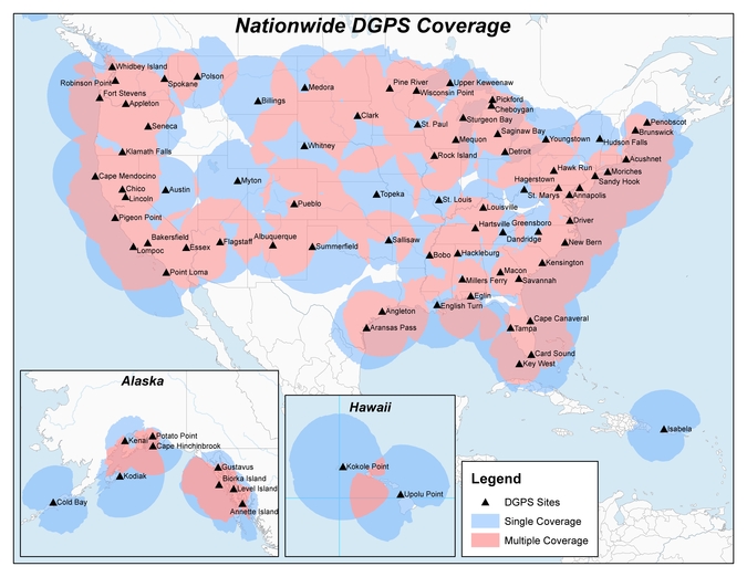
The United States Coast Guard, Department of Transportation and Army Corps of Engineers have issued a notice that reduces the number of Nationwide Differential Global Positioning System (NDGPS) sites that will be decommissioned.
The agencies published a notice on Aug. 18, 2015, seeking public comments on the proposed shutdown and decommissioning of 62 the then-existing 84 NDGPS sites.
“After a review of the comments received, we have reduced to 37 the number of NDGPS sites to be shut down, nine of which are USCG Maritime sites and 28 of which are DOT inland sites,” the notice reads. “As a result of this action, the NDGPS system will remain operational with a total of 46 USCG and USACE sites available to users in the maritime and coastal regions.”
Over time, a number of factors have contributed to the declining public use of the NDGPS, including lack of a carriage requirement, technological advances in GPS and limited availability of consumer-grade DGPS receivers.
The Federal Register Notice reduces the number of Differential GPS sites throughout the country, while maintaining coverage in major maritime ports and waterways.
Read the full notice at the Federal Register website, including a list of sites to be decommissioned. Termination of the broadcast signal is scheduled to occur within the next 30 days.
Graphic depicting NDGPS after site reductions. (U.S. Coast Guard)Graphic depicting NDGPS coverage after site reductions. (U.S. Coast Guard)Original NDGPS coverage.
The U.S. Coast Guard issued a safety alert on Jan. 16, warning mariners of the potential detrimental impact to navigation caused by GPS interference or jamming. The warning emphasizes the importance of understanding how vessel equipment could be impacted by the loss of a GPS signal.
The Coast Guard states that this past summer, multiple outbound vessels from a non-U.S. port suddenly lost GPS signal reception. The net effect was various alarms and a loss of GPS input to the ship’s surface search radar, gyro units and ECDIS, resulting in no GPS data for position fixing, radar over ground speed inputs, gyro speed input and loss of collision avoidance capabilities on the radar display.
Fortunately, the vessels were able to safely continue theirvoyage using radar in heads up display, magnetic compass and terrestrial navigation. Approximately six nautical miles later, the vessels’ GPS units resumed operation. Although the vessels had back-up systems to allow a safe transit, the consequences could have been severe, warns the Coast Guard.
Full content of the alert appears below.
Global Navigation Satellite Systems – Trust, But Verify Report Disruptions Immediately
Do you know what equipment relies upon the U.S. Global Positioning System (GPS) signal? How would you respond if you lost the signal? This past summer, multiple outbound vessels from a non-U.S. port suddenly lost GPS signal reception. The net effect was various alarms and a loss of GPS input to the ship’s surface search radar, gyro units and Electronic Chart Display & Information System (ECDIS), resulting in no GPS data for position fixing, radar over ground speed inputs, gyro speed input and loss of collision avoidance capabilities on the radar display. Fortunately, the vessels were able to safely continue their voyage using radar in heads up display, magnetic compass and terrestrial navigation. Approximately 6nm later, the vessels’ GPS units resumed operation. Although the vessels had back-up systems to allow a safe transit, the consequences could have been severe. These types of events highlight the potential detrimental impact to navigation caused by GPS interference or jamming and the importance in understanding how your vessel’s or facility’s equipment could be impacted by a loss of GPS signal.
Whether walking through the city, driving across town or navigating the world, Global Navigation Satellite Systems (GNSS) have become an integral part of everyday life. However, at times, the positioning signals may be impacted by interference from both natural and human-made sources. The most common types of interference are reception issues, usually due to bad installations, poor antenna positioning or faulty equipment. Jamming devices, while illegal in the U.S. and a threat to safety, have been used for nefarious or deceptive purposes. Interference can also be unintentionally caused when operating GNSS in close proximity to other radiating devices, such as amplified TV antennas (see our Safety Alert 11-02). Therefore, it is important to remember to use all available means for navigation and maintain proficiency so you can still navigate should your primary GPS fail.
Indicators of positioning systems interference include an intermittent signal, no signal, or an incorrect signal. Suspected or suspicious disruptions should be reported immediately. Critical information to take note of during a disruption event includes location, time, and period of outage.
Commercial operators are reminded, should your navigation or other equipment onboard (e.g. AIS) be impaired as a result of a disruption or interference, this should be reported to the nearest U.S. Coast Guard Captain of the Port, District Commander or Vessel Traffic Center as soon as possible; and, await further directions (per 33 CFR 164.53).
All operators should be aware, vigilant, and immediately report GPS disruptions to the U.S. Coast Guard Navigation Center (NAVCEN). The report will be disseminated to the U.S. Air Force GPS Operations Center and the Federal Aviation Administration in an attempt to identify the problem and correlate with any other GPS incidents in the same general geographic location. Depending on the severity of the report, NAVCEN may refer it to law enforcement and/or other federal agencies for further investigation.
Reporting a disruption — or other navigation hazards or aids to navigation outages — is simple, and can be done electronically (http://www.navcen.uscg.gov, the preferred method) or via phone call to the NAVCEN (703- 313-5900), 24 hours a day.
According to UrsaNav Inc., the Wildwood, NJ eLoran transmitter will be continuously broadcasting from 0900 (EST) on 21 October 2016 through 1200 (EST) on 22 November 2016. Wildwood will be broadcasting as 8970 Master and Secondary most of the time but occasionally may operate at other rates.
The team will evaluate eLoran as a potential complementary system to GPS. The capabilities and potential utilization methods of eLoran will be explored in depth to identify all strengths, capacities, and potential vulnerabilities of the technology.
The sites are the legacy ground-based radio navigation infrastructure of the decommissioned Loran-C service that could be retained and upgraded to provide eLoran low frequency service.
Under the CRADA, Exelis will use the former Loran-C assets to put eLoran signals in space for research, test and demonstration of the ability of eLoran to meet precise positioning, navigation and timing (PNT) requirements of government and privately-owned critical infrastructure.
The first station Exelis is broadcasting from is in Wildwood, N.J. The broadcasts will provide a usable signal at a range up to 1,000 miles.
Let us not exaggerate — nor prematurely announce — the death of a subsystem. However, the demise of the U.S. Nationwide Differential GPS (NDGPS) network can be confidently foretold. Although a Federal Register notice dated Aug. 18 merely seeks public comment on plans to shut down a large portion of NDGPS, the handwriting is on the wall. Once having writ, the hand of fate moves on.
We should neither lament nor applaud. NDGPS, like many other technologies, has seen its time come and go, while competitors have arisen to perform its role and take its place. Such is evolution in the industrial world as well as in the biological kingdoms.
In 2016, three quarters of the currently operating NDGPS reference stations will be taken down and decommissioned. That’s not what the federal notice states, but that’s what it effectively says. The document’s comment period ends on Nov. 16. It is difficult to conceive of a public outcry that might reverse the intended course of the U.S. Coast Guard, Department of Transportation and Army Corps of Engineers.
The NDGPS network had its birth in the 1980s, as a tool to provide real-time positioning accuracy for harbor entrances and coastal navigation. Inland components were added over the years to improve river navigation, NDGPS use in precision agriculture began to grow, and a role in railroad positive train control (PTC) was much discussed. But all these efforts could not gather enough momentum to firmly establish the network’s viability. Meanwhile, satellite-based differential services from both commercial providers and the U.S. government’s own Wide Area Augmentation System (WAAS), and a network of continuously operating reference stations (CORS) from the National Geodetic Survey continually nibbled away at NDGPS’s potential customer base. Consequently, industry fielded a meager range of radiobeacon DGPS receivers.
The real death blow came in 2013, when the Federal Railroad Administration (FRA) eliminated an NDGPS requirement from its PTC program. The railroads, never a nimble industry nor one receiving the governmental support it enjoys in other countries, had by that time become the last hope of NDGPS. Ag users had already for the most part moved over to WAAS and commercial SBAS providers. Marine users did not by themselves form a sufficiently large constituency, and even they were not fully equipped nor wholesale adopters of the system.
The story of Loran bears some similarities to NDGPS, but Loran now enjoys a resurgence that NDGPS will never see. It is destined for the technological graveyard. There is an ecosystem of positioning, navigation and timing (PNT) tools and applications. Operating in a free market, with some measure of governments’ interference and manipulation, it has its own patterns of natural selection. We will continue to see the rise and fall of species. NDGPS has now been branded a dinosaur. It will be interesting to see how other technologies, competing for the same finite range of resources, will interact, thrive, or decline.
In this exclusive interview, Admiral Thad Allen, former commandant of the U.S. Coast Guard, discusses PNT alternatives to GPS for navigation, including eLoran and the activation June 19 of a signal on an eLoran tower in preparation for a timing signal trial.
Art Kalinksi interviewed Adm. Allen during GEOINT 2015, held June 22-25 in Washington, D.C. Kalinski is the monthly columnist for Geointelligence Insider, part of the Geospatial Solutions website, a sister site to GPS World magazine.
Allan is an executive vice president at Booz Allen Hamilton, and a leader in the firm’s Departments of Justice and Homeland Security business in the civil market. In 2010, President Obama selected him to serve as the National Incident Commander for the unified response to the Deepwater Horizon oil spill in the Gulf of Mexico.
(fFrom left) Congressman LoBiondo, UrsaNav CEO Chuck Schue and Harris Division President Pam Drew. (hoto Credit: Andrei Grebnev, UrsaNav)
As of June 19, eLoran is on the air in the United States. The low-frequency signal emanates from a single station, a former U.S. Coast Guard Loran Unit in Wildwood, N.J., which sports a 625-foot signal mast that has been out of action for five years. The signal is receivable at distances of up to 1,000 miles.
The facility began generating eLoran pulses at the press of a command button by Congressman Frank LoBiondo (R, N.J). Present for the ceremonial start of a 12-month demonstration and research program under the aegis of the Department of Homeland Security were project participants Charles Schue, CEO of UrsaNav; Pam Drew, president of Harris Information Systems; and Dana Goward, president of the Resilient Navigation and Timing Foundation.
Brief remarks delivered at the turn-on collectively made the key points that:
GPS services are essential to national and economic security, yet are vulnerable to disruption.
The eLoran navigation and communications signal has features that are complementary to GPS, making it difficult to disrupt; further, it could be an important part of enabling UAVs to fly safely in our airspace.
The U.S. Federal Radionavigation Plan cites not being critically dependent upon a single system for positioning, navigation, and timing as a national policy objective. The plan specifically identifies eLoran testing as an important step toward reaching that objective.
The two engineering companies, UrsaNav, a supplier of eLoran technology, equipment, and services, and Harris (which recently acquired Exelis), provide funding and technology for the tests supported by the U.S. Coast Guard, Department of Defense, Department of Homeland Security and other federal agencies under a Cooperative Research and Development Agreement (CRADA) announced in May.
The team will evaluate eLoran as a potential complementary system to GPS, exploring the capabilities and use methods of eLoran in depth to identify all strengths, capacities, and potential vulnerabilities of the technology. One goal of the CRADA is to reduce the size, weight, cost, power needs and other aspects of Loran, similar to what has evolved with GPS.
“This is a phoenix arriving. We have the opportunity to add 2015 technology to the older idea,” said Schue of UrsaNav, once Coast Guard commanding officer at the former Loran station. “A prudent mariner always has two systems to navigate.”
Dana Goward, also a retired Coast Guardsman whose non-profit Resilient Navigation and Timing Foundation is working on the project, stated that eLoran can attain positioning accuracy of six meters or better.
“We will explore many places eLoran can be deployed where GPS isn’t available such as deep canyons, through buildings, in foliage and under water,” added Harris Corp.’s Drew. “We’re involved with unmanned aerial drones, and eLoran could be key. There are applications for civilian and military uses.”
In this GPS World exclusive video, Admiral Thad Allen, former commandant of the U.S. Coast Guard, discusses PNT alternatives to GPS for navigation, including eLoran and the activation this week of the signal on the eLoran tower in New Jersey.
eLoran in Europe
Matters have moved a little further along in Europe. In 2013, the General Lighthouse Authorities of the UK & Ireland (GLA) established prototype eLoran Initial Operating Capability (IOC) in the United Kingdom, where eLoran now delivers PNT data at the 10-meter level from a network of high-power, low frequency, terrestrial transmitters.
“To get high accuracy from eLoran requires accurate calibration of Additional Secondary Factor (ASF) through measurement,” according to paper delivered at the Institute of Navigation’s 2015 Pacific PNT meeting. “Can eLoran Deliver Resilient PNT?” was authored by Nick Ward, Chris Hargreaves, Paul Williams, and Martin Bransby of the GLA.
The older Loran-C system suffered from significant positioning bias errors due to a number of radio frequency signal propagation delay factors, they write. “The Primary Factor (PF) is due to the signal travelling slower in air than free-space, the Secondary Factor (SF) is due to the presence of the Earth’s surface and the electrical properties of the oceans. Additional Secondary Factor (ASF) is due to the additional electrical resistance encountered by non-seawater terrain, land, mountains, deserts, and so on. PF and SF can be modeled, but to get high accuracy from eLoran requires accurate calibration of ASF through measurement.
“To do this,” they continue, “ASF surveying and mapping has been conducted along the port approach channels at Aberdeen; along the Firth of Forth; Middlesbrough; Hull and the Humber Estuary Traffic Separation Scheme (TSS); Harwich and Felixstowe; The ports of London, Medway and the approaches past the London Array wind-farm and also through the Dover Straits.
“To complement these services, seven differential-Loran (DLoran) Reference-Stations, one located close to each of these survey areas have been established. These stations monitor the time of arrival of the received eLoran signals, and generate differential-corrections that are broadcast via the Anthorn Loran Data Channel (LDC), to account for temporal variations in these ASF maps.
“Making use of these ASF maps, combined with the locally-produced differential corrections, can allow a maritime user of eLoran IOC to obtain position accuracy of the order of 10m (95%), within a radius of 30 to 50 km of the DLoran reference station.”
eLoran can deliver Resilient PNT and this has been demonstrated on several vessels.
Seamless handover from primary (GPS) to secondary (eLoran) positioning source has been successfully implemented.
Surveying and mapping of ASF has been carried out for several major ports and the required levels of performance demonstrated.
DLoran reference stations to correct for short-term, temporal variations have been installed and commissioned.
Good levels of performance have also been demonstrated for coastal voyage phase away from the ASF surveyed areas.
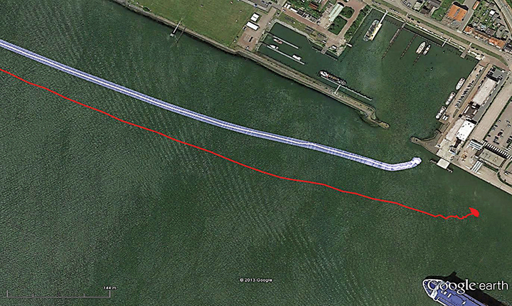
eDLoran in Rotterdam. The July 2014 issue of GPS World presented a cover story showing results of a newer version, enhanced differential Loran (eDLoran), yielding position accuracies of approximately 5 meters.
Potential GNSS Back-up Improves to GPS-Level Accuracy
A new enhanced differential Loran system demonstrates 5-meter accuracy not achievable by the current DLoran system, and requires less expensive reference stations. A prototype tested in Rotterdam’s Europort area uses standard mobile telecom networks and the Internet to reduce correction data latency — a key source of error — by one to two orders of magnitude.
By Durk van Willigen, René Kellenbach, Cees Dekker, and Wim van Buuren
Figure 12. The large ship symbol (grey) is derived from the GPS-RTK receiver of the Rotterdam pilots. The width of the ship symbol is 10 meters and the speed-over-ground was 11 kts. The red triangle is generated by the eDLoran receiver and remains between the required ± 5 meter limits for eDLoran.Figure 13. The red track is based on raw eLoran data without any corrections. The transparent blue line is made by GPS-RTK and is widened to 10 meters giving the required ± 5 meter limits of eDLoran. The white line is output from the eDLoran receiver which stays within the borders of the 10 meter wide transparent blue line.
The GLA authors from the UK give a perspective on the Rotterdam project, as follows:
“A compatible system (eDLoran) has been developed for operation by ships’ pilots on the Europort approach to the Port of Rotterdam.
“However, Loran is a regional system dependent on international collaboration. The 9 transmitters in northern Europe are operated by Denmark, France, Germany, Norway and the UK.
“Both Norway and France have declared an intention to cease Loran transmissions at the end of 2015. Moreover, France intends to dismantle its Loran infrastructure in 2016. Arrangements for the commercial operation of the infrastructure are being investigated, but this depends on some form of regional agreement. The European Union appears to have no policy for resilient PNT, the European Radio Navigation Plan having twice been drafted but never published. The view seems to bee that the introduction of Galileo will achieve resilient PNT, which it will not.”
And Elsewhere
South Korea is implementing a national eLoran service, and it is understood that similar plans are being considered in Russia and China.
Exelis, UrsaNav, the Department of Homeland Security’s Science and Technology Directorate (DHS S&T), and the U.S. Coast Guard have entered into a cooperative research and development agreement (CRADA) for testing and demonstration at former Loran-C sites.
The team will evaluate eLoran as a potential complementary system to GPS. The capabilities and potential utilization methods of eLoran will be explored in depth to identify all strengths, capacities, and potential vulnerabilities of the technology.
The sites are the legacy ground-based radio navigation infrastructure of the decommissioned Loran-C service that could be retained and upgraded to provide eLoran low frequency service.
Under the CRADA, Exelis will use the former Loran-C assets to put eLoran signals in space for research, test and demonstration of the ability of eLoran to meet precise positioning, navigation and timing (PNT) requirements of government and privately-owned critical infrastructure. The first station Exelis will broadcast from is located in Wildwood, N.J. The broadcast will provide a usable signal at a range up to 1,000 miles.
“eLoran is an ideal technology to complement GPS for critical, resilient and assured PNT,” said Ed Sayadian, vice president of Civil & Aerospace Systems for Exelis. “eLoran is a difficult to disrupt technology that offers PNT and wide area broadcast data capabilities indoors, in underground locations and other GPS-denied environments.”
“A preponderance of government, academic, and industry reports have concluded that eLoran is the best independent, multi-modal solution to provide assured PNT as a complement to GPS,” said Chuck Schue, president and CEO of UrsaNav.
Exelis and UrsaNav have entered into this CRADA because they believe that low frequency signals, such as eLORAN, operate independently of GPS signals and can provide alternative timing, either standalone, or as a component of a PNT service. Exelis also believes that as a result of its wealth of experience in its PNT portfolio, that there are many civil and defense applications that require precise time and/or position in GPS-denied environments. Examples include radio frequency interference, both intentional and unintentional; signal attenuation from heavy forest canopy, terrain or buildings; and indoor and underground locations.
Jamming Signals Criminal Activity in Intermodal Ports
By Logan Scott
More than 25 million containers pass through U.S. intermodal ports every year, with port operations valued at more than $1 billion per day. Measured in 20-foot equivalent units (TEU), the World Bank reports that worldwide, more than 600 million TEU passed through intermodal ports in 2012: 155 million through Chinese ports, 95 million through the EU ports and 43 million through U.S. ports.
The Port of Long Beach alone handled 6,820,806 TEU in 2014. GPS is a central component of automated port operations, but because GPS is widely used in asset tracking and monitoring, it has also become a target for denial-of-service attacks. If we look to the history of computer security, the initial attacks were mostly nuisances, but as criminals figured out how to monetize attacks, the attacks became more damaging, more sophisticated and more profitable.
In January, the U.S. Coast Guard held a public meeting on Maritime Cybersecurity Standards at Department of Transportation headquarters in Washington, D.C. Brett Rouzer, chief of Maritime Critical Infrastructure and Key Resources Protection, Coast Guard Cyber Command, described how a major East Coast intermodal shipping facility was degraded by a GPS disruption for more than seven hours. Two ship-to-shore cranes ceased operation due to loss of position, and two others were degraded. Ports are highly automated; ship-to-shore cranes are just one of the container-handling systems critically reliant on GPS. Fully automated ports providing services for unmanned container ships, trucks and trains lie within the realm of feasibility in the near future.
Rouzer did not specify the motivates for the disruption, how the attack was mounted, or if the shipping facility was even the intended target of the attack (I suspect it was not). Jamming is not a highly selective process, and it can affect numerous unintended targets.
In June 2014, I reported to the PNT Advisory Board on how every third or fourth truck on Highway 30B near Portland (Oregon) International Airport was radiating at or near the GPS L1 frequency. This highway leads to several nearby Port of Portland intermodal terminals west of the airport. The Federal Bureau of Investigation recently reported that “In 46 reported incidents, the thieves placed one or more GPS jammers in cargo containers with stolen automobiles” (italics mine). High-end automobiles command premium prices in foreign markets and are stolen and shipped out of the country within hours, usually via intermodal container. Active jammers can affect not only the automobile’s GPS tracker, but also trackers on other containers, ship’s navigation systems, straddle carriers and ship-to-shore cranes. Again, jamming is not selective.
Of particular note as cited above, criminals are beginning to use multiple jammers. Car theft rings are not unique in this. According to the Pharmaceutical Cargo Security Coalition in July 2014, “a tractor and trailer hauling $2 million worth of pharmaceutical products was stolen from a truck stop in Cartersville, Georgia, with the thieves deploying two separate GSM jammers.” The criminal’s motivation is that tracking devices can be hard to find and disable; just because you found one doesn’t mean that there isn’t another. The use of multiple jammers in criminal enterprise is indicative of a threat escalation where bad actors are seeking higher effect. This could lead to higher jamming powers and so on; and also more collateral damage.
Response
What is a correct and measured response to threats against navigation and timing? The key is to be on the lookout for emerging threats and to have a flexible response. Early detection usually yields a more effective and lower cost response; witness Ebola and ISIS. Following a public health model would seem to offer better prospects for protecting access to PNT. To this end, I would argue that situational awareness is the first important step.
One of the most striking comments that Sarah Mahmood (DHS) made at last June’s PNT Advisory Board meeting was about how backup systems are often not activated or used because the GPS receiver fails to recognize that there is a problem. As we move towards resilient PNT architectures, one of the most critical needs is to be able to distinguish good signals from bad signals and act accordingly.
Most GNSS receivers already have fairly advanced jamming detection capabilities by virtue of having an automatic gain control. Sudden changes in precorrelation input power levels are not normal and can indicate jamming or RF spoofing. Many GNSS receivers, particularly those that go into embedded mobile applications, also have sophisticated spectrum- and temporal-analysis capabilities, used mainly for diagnostic purposes in looking for interference sources from other components of the device. This same capability can be used in detecting and fingerprinting jammers. We already have the smoke alarms; we must amplify their use and visibility to the wider community of GNSS users and beyond.
Detection
One notable aspect of the port incident was the duration: more than seven hours. Rapidly finding and disabling the jammer was clearly a problem in this case. The old adage is that to find a stationary source (jammer) you need to be moving, and to find a moving source, you need to be stationary. Trucks and trains entering or leaving a port all pass through gates that can act as a simple chokepoint for detecting and finding active jammers. Properly hardened ship-to-shore cranes and straddle carriers can also act as a chokepoint. Straddle carriers used in moving containers around the yard and between modes could be very good at finding stationary jammers.
There are numerous relatively low-cost approaches for finding jammers in support of enforcement actions. One additional point: law enforcement officials need to be better educated as to why they should be interested in jammers; jammers point towards a crime much like smoke points to a fire.
Given the economic criticality of port operations and the concentration of assets (and asset trackers), we may see increased incidence of GPS disruptions. The situation is not critical yet, but it does bear watching. If jamming events increase or it takes too long to find and disable jammers, improved operational resilience will be needed.
Inertial measurement units are already used in many critical applications, but they don’t offer long-duration capability. They drift. Using adaptive arrays in critical equipments is another possibility, but they are not a panacea. Adaptive arrays are physically large, and standard null-steering approaches are not compatible with RTK processing. Precise positioning systems based on GNSS require specialized antenna-receiver designs to achieve a high level of jam resistance.
While I strongly believe eLoran is an urgently needed augmentation for resilient wide area navigation, it is not capable of the centimeter-level precision required for machine control, for example ship-to-shore cranes and straddle carriers.
High-precision local-area positioning systems based on optical systems, RFID and/or Locata-style systems may be the best approach for creating a defense in depth.
And then there is the cybersecurity question, which I will leave for another day.
Note: A video of the Coast Guard meeting is on YouTube. Rouzer’s talk starts at 36:30, with the port jamming incident mentioned at 48:51.
Logan Scott has 35 years of military and civil GPS systems engineering experience. He is a consultant specializing in radio frequency signal processing and waveform design. At Texas Instruments, he pioneered approaches for building high-performance, jamming-resistant digital receivers. He is a co-founder of Lonestar Aerospace, an advanced decision analytics company in Texas. Logan is a Fellow of the Institute of Navigation and holds 37 U.S. patents.