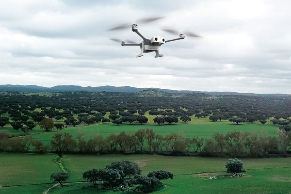
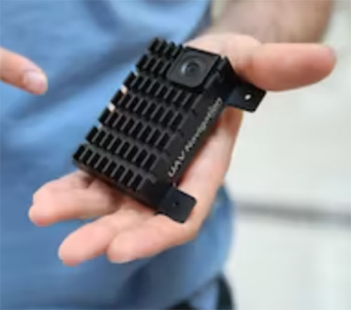
Percepto has announced the U.S. Federal Aviation Administration (FAA) has approved the use of its UAV-in-a-box solution to perform highly automated beyond visual line of sight (HA BVLOS) inspections and monitoring operations at a large solar power plant in Texas.
The HA BVLOS UAV will fly at 200 feet above ground, which is double the altitude of any previously approved operation in the United States. The ability to fly at a higher altitude will enable greater operational flexibility to monitor large areas and tall structures in the future, including mapping and modeling.
Percepto’s HA BVLOS UAV enables an automated detect and avoid cycle, eliminating the need for remote pilot in command interventions if other aircraft are detected. Additionally, this capability negates the need for a pilot or visual observer on site.
The FAA approval for the solar plant deployment serves as a model for other industries including mining and oil and gas, to potentially increase site efficiency through automated remote inspection operation.
In December 2022, uAvionixannounced its updated product line for unmanned aerial systems (UAS) beyond visual line of sight (BVLOS) command and control (C2). The SkyLine C2 management platform and muLTElink airborne radio systems (ARS) are designed to integrate, which enables a self-healing C2 network capable of both path and link diversity. This eliminates lost-link possibilities over broad terrain and altitude ranges.
Image: uAvionixImage: uAvionix
MuLTElink ARS consists of two models — muLTElink915 and muLTElink5060, the core of the uAvionix C2 system. The muLTElink915 model combines globally licensed aviation LTE, enhanced with frequency hopping 902–928 MHz industrial, scientific and medical frequencies capability. The muLTElink5060 model combines global LTE with aviation-protected 5,030–5,091 MHz C-band for customers holding C-band licenses for control and non-payload communication (CNPC) operations.
Each muLTElink model allows up to one external CNPC radio to be optionally connected to allow simultaneous use of all three frequency ranges, higher power C-band operation or future radio integrations.
UAvionix updated its previous line of microLink and SkyLink ARS radios and relaunched them under the SkyLink ARS banner. Each SkyLink ARS can operate as a point-to-point radio or integrate with muLTElink and SkyLine for managed C2 operations. SkyLink915micro, formerly named microLink, offers a robust form factor and Lemo connector for UAS requiring hardened installations.
SkyLink5060micro and SkyLink5060 offer 100 mW and 10 W 5,030–5,091 MHz aviation protected C-band CNPC options.
Both platforms meet standards set by RTCA DO-362A and the U.S. Federal Aviation Administration’s draft Technical Standard Orders-C213a and may receive similar validated orders through other global aviation regulators.
The Army tested the EGI units with enabled M-code on the MQ-1C Gray Eagle unmanned aerial system and validated it to be deployed on military aircraft. This year, the Army will begin migrating its fleet to the Honeywell EAGLE-M EGI with M-code, as this navigation solution enhances the resiliency of GPS navigation to enemy actions.
Image: Honeywell
The defense technology company has delivered more than 300 EGIs with M-code to customers and will deliver qualified units, featuring M-code GPS, to the Army. Honeywell is a leader in EGI for military applications and has provided more than 45,000 EGI units for several different types of aircraft in more than 30 countries.
In October 2022, Raytheon Missiles & Defense, a Raytheon Technologies company, received a $207 million contract from the United States Army for Ku-band radio frequency sensors (KuRFS) and Coyote effectors. The Army plans to equip two of its divisions with KuRFS and Coyote effectors to defend against threats from unmanned aerial systems (UAS).
The KuRFS precision targeting radar and scaled Ku-720 mobile sensing radar provides 360-degree detection, identification and tracking of airborne threats. Coyote Block 2 kinetic and Block 3 non-kinetic effectors can defeat single UAS and swarms at high altitudes and long ranges.
The Army’s Mobile-Low, Slow, Small, Unmanned Aircraft Integrated Defeat System, integrates KuRFS and Coyote effectors with Northrop Grumman’s Forward Area Air Defense Command-and-Control system and Syracuse Research Corporation’s electronic warfare system. This creates a mobile deployed system that provides a complete extended-range defense solution.
A roundup of recent products in the GNSS and inertial positioning industry from the December 2022 issue of GPS World magazine.
AUTONOMOUS
Flight Controller
Turns a UAV into a connected autonomous system
Photo: Auterion
Skynode reference-design hardware is built with Remote ID in mind, enabling UAV users to comply with the FCC rule Remote Identification of Unmanned Aircraft (Part 89). A built-in connectivity stack with 4G, Bluetooth and Wi-Fi enables automatic real-time data transmission from the UAV to the cloud. Built on open standards, Skynode is flexible and extensible, allowing users to leverage a variety of compatible software and hardware components. The connections enable automatic sending of logs, images and real-time video streams from the field to remote experts.
The VoloDrone is a fully electric, heavy-lift utility UAV with a range of up to 25 mi carrying a carrying a 440-lbs payload. The rotor area has a diameter of 30 ft, and the vehicle is 7.5 ft high. It can be remotely piloted or can fly autonomously on preset routes. Loads can be carried between the legs of the landing gear on standard rack mounts or slung below, or a tank and sprayer could be fitted for agricultural applications. The 18-rotor multicopter platform uses swappable lithium-ion batteries and an in-house flight control system, and benefits from existing development and test of the Volocopter air-taxi.
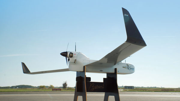
With a wingspan of 4.20 m, the BOREAL NRM remotely piloted aircraft integrates efficient photogrammetry devices for mapping large areas, even in areas inaccessible to traditional mapping aircraft. Its flight-control system is designed for image-capture management and optimal coverage of areas greater than 20,000 ha. The BOREAL NRM offers an overall and precise view of cultivated areas (1 cm to 3 cm per pixel), simplifying crop monitoring and facilitating human intervention in places that require it (such as water stress, treatment of pests).
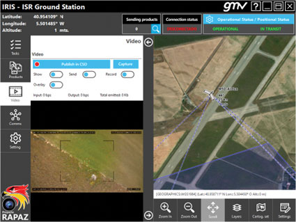
The IRIS unmanned vehicle command-and-control system provides intelligence, surveillance and reconnaissance (ISR) interoperability — essential aspects of any military operation. The IRIS system integrates unmanned vehicles with other command-and-control systems for monitoring and gathering information for a variety of operational scenarios. IRIS uses each unmanned vehicle’s own communication systems and 5G technology to provide situational awareness for decision makers before and during operations. A simplified interface allows integration of sensors and platforms into a command-and-control network, providing interoperability with other command, control, communication and computer ISR (C4ISR) systems. IRIS performed well during NATO’s REPMUS 22 (Robotic Experimentation and Prototyping Augmented by Maritime Unmanned Systems) exercise in September.
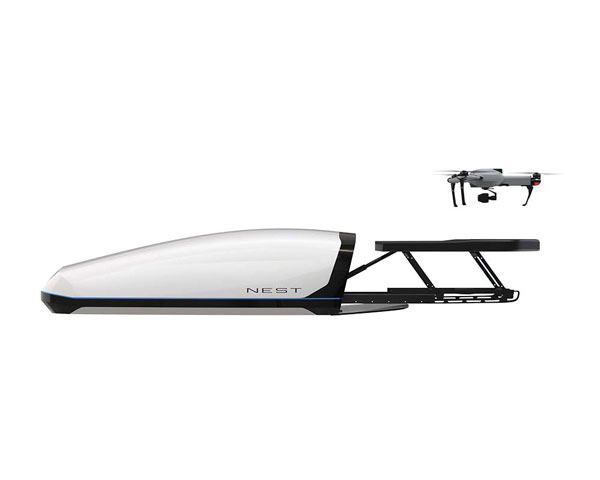
The AtlasNEST UAV system features a docking station to provide fully autonomous 24/7 readiness for infrastructure inspections, emergency situations and security missions requiring shared situational awareness and management. Using the AtlasSTATION interface, an operator sets a target destination, and the lightweight UAV deploys in less than three minutes. Sending a drone to collect visual data and reveal possible problems can help prevent putting personnel in unsafe circumstances. AtlasNEST has built-in artificial-intelligence technologies, including autonomous battery swapping. Using the AtlasSDK, AtlasNEST can be incorporated into current security systems.
Turf Tank is an autonomous, GNSS-guided line-marking robot built specifically to paint lines on athletic fields. More than 550 Turf Tank robots are deployed across the United States, painting athletic fields at public schools, major colleges and universities, amateur and professional soccer clubs, local parks and recreation departments, and at two National Football League stadiums. The Turf Tank robots can paint a full soccer field in less than 30 minutes, compared to two or three hours for manual painting. Similarly, the robot can paint a football field in two or three hours compared to eight to 10 hours to paint a football field. The robots are eco-friendly — they’re powered by rechargeable batteries and use far less paint than most older paint machines.
The Autel EVO II Pro Series combines Carlson’s software and hardware surveying and mapping solutions with a UAV from Autel Robotics. The Carlson suite is designed to take professionals throughout a project’s lifecycle: setting ground control points with the Carlson BRx7 GNSS receiver and RT4 data collector with SurvPC field software, the drone flight, PC photo and data processing, and creating finished plans in CAD.
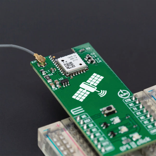
The GPS 5 Click is a compact add-on board that provides users with positioning, navigation and timing (PNT) services. The board features the M20050-1, a GPS module using the MediaTek MT3333 flash chip and an Antenova GNSS receiver for optimum performance. The receiver tracks three GNSS constellations concurrently (GPS + Galileo + GLONASS or GPS + Galileo + BeiDou) and has configurable low-power modes operating from a 3.3V power supply. In addition to the possibility of using an external antenna, backup power, and various visual indicators, the M20050-1 has an accurate 0.5 ppm TXCO ensuring short time-to-first-fix and multipath algorithms that improve position accuracy in urban environments.
Modules GT-100, GT-9001 and GT-90 are time-synchronization GNSS receiver modules compatible with all GNSS systems. The three modules deliver nanosecond precision for 5G mobile systems, radio communications systems, smart power grids and grandmaster clocks. Each suits different applications based on supported frequency bands and output signals. GT-100 supports concurrent L1 and L5 reception and delivers three outputs including 1 pulse per second (1 PPS) synchronized with UTC as well as user-programmable frequencies. The outputs can be set to 10 MHz, 2.048 MHz and 19.2 MHz, reducing time to market and saving costs through reduced component needs. GT-9001 supports L1 and delivers high-stability 1PPS and programmable clocks on three channels. GT-90 supports L1 and provides a 1 PPS high stability output. All models have time stability of 4.5 ns (1 sigma) and are equipped with multipath mitigation to minimize degradation of performance in urban areas.
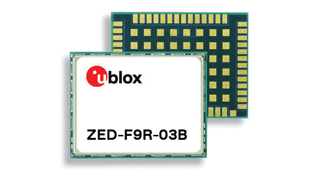
The latest firmware update for the u-blox ZED-F9R high-precision GNSS module adds support for Japan’s QZSS CLAS correction services (ZED-F9R-03B). The ZED-F9R also now supports u-blox SPARTN 2.0 correction data.
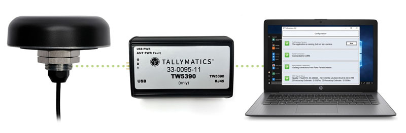
The TW5390 smart antenna has IP network and L-band augmentation service capability. Along with a Tallymatics antenna, it has a high-precision u-blox F9R GNSS receiver and DS9 L-band receiver modules. The combination delivers a reliable and convenient smart antenna yielding <6-cm accuracy, with precise point positioning/real-time kinematic (PPP/RTK) augmentation services via the PointPerfect subscription service. The antenna provides superior multipath rejection with Tallysman Accutenna technology, a low noise amplifier, Tallysman’s eXtended Filtering (XF) technology, which mitigates saturation from nearby RF signals (targeting LTE and Ligado), a tight, measured phase-center offset and low axial ratio, enabling accurate and precise positioning, direct decoding of PointPerfect, SPARTN formatted augmentation packets (u-blox specific)
Tracking enables potential applications and projects
Photo: TE Connectivity
The Lembas LTE/GNSS USB modem provides plug-and-play GNSS tracking as well as LTE and CAT4 network connectivity via a robust USB interface to a variety of small-board computers utilizing the ARM chipset. Through a single-command setup process, users can have GNSS access to a wide variety of projects. The modem has been tested with Raspberry Pi Model B, Odroid XU4 and N2, ASUS Tinker Board, and NVIDIA Jetson Nano.
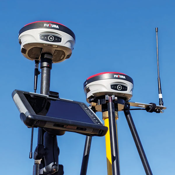
The universal construction site supervisor system is designed to help contractors manage all their job site activities. It includes the SiteMetrix Grade and the multi-frequency, multi-GNSS F631 RTK base and rover. SiteMetrix is user friendly, easy to understand and portable. Contractors can use the Futtura system to localize sites, check grade, configure base stations, set stakes and calculate volumes of material removed. Users will see the benefit of seamlessly performing data collection and layout, all in one easy-to-use application, the company says. The F631 GNSS receiver is powered by SureFix RTK technology, which offers a real-time dual-solution point verification. The F631 GNSS receiver is powered by Hemisphere GNSS’ Athena RTK technology. With Athena, F631 provides state-of-the-art RTK performance when receiving corrections from a static base station or network RTK correction system. With multiple connectivity options, the F631 allows for RTK corrections to be received over radio, cell modem, Wi-Fi, Bluetooth, or serial connection. F631 delivers centimeter-level accuracy with virtually instantaneous initialization times and robustness in challenging environments.
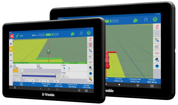
The Trimble GFX-1060 and GFX-1260 next-generation displays for precision agriculture applications enable farmers to complete in-field operations quickly and efficiently while also mapping and monitoring field information in real time with precision. Both displays feature an Android-based operating system and enhanced processing power for controlling and executing in-field work. The new flagship GFX-1260 is a 12-in (30.5 cm) display, while the GFX-1060 is a 10-in (25.6 cm) display, and both are compatible with the Trimble NAV-500 and NAV-900 GNSS guidance controllers. The displays are ISOBUS-compatible, which allows one display or terminal to control ISOBUS implements, regardless of manufacturer. The displays enable farmers to set up and configure their equipment through Trimble’s Precision-IQ field software, including manual guidance, assisted and automated steering, application controls, mapping and data logging, equipment profiles and camera feeds from attached inputs and other internet-based apps.
Enables affordable smart construction upgrades for fleets
Photo: Komatsu
The Smart Construction Retrofit kit turns a conventional Komatsu excavator “smart” with 3D guidance and payload monitoring. With a kit installed, an operator is no longer required to set up a laser or bench every time the machine moves. The kit’s GNSS receiver determines where a machine is on the job site and what the target grade is. The need for additional labor is reduced because the technology collects and delivers information directly to the operator. Designed to improve grading performance and provide more time- and cost-management tools, Smart Construction Retrofit kits can bring 3D to most Komatsu excavators in a fleet. The kit gives operators the latest design data, measures payload volumes and load counts, and allows managers to monitor production from the office by integrating Smart Construction applications. The payload meter helps prevent overloading trucks by promoting proper loading weights for on- and off-road vehicles, to reduce the potential for equipment damage and other risks.
The SAgro10 GNSS is an upgradeable entry-level guidance system for precision agriculture, which can be easily upgraded to the SAgro100 automatic steering system. Equipped with a high-precision GNSS module, the SAgro10 tracks all constellations. For users with network coverage or a UHF base station, the SAgro10 system provides centimeter-level accuracy navigation in real-time kinematic mode. In the absence of base stations, it can still provide sub-meter navigation accuracy in single-point smoothing mode. The system is compatible with most agricultural tractors and can be installed in 15 minutes. It supports a 10-in sunlight-readable touchscreen with a clear graphic interface. The SAgro10 software can intelligently manage the work area and simplify user operations, such as recording the completed work area and planning the work route.
An independent study conducted by UAV Navigation has defined the operational envelope of the VECTOR-600 autopilot based on the Specific Operations Risk Assessment (SORA) methodology. The operational envelope defines the operational risk profile within which an aircraft can operate safely, taking into consideration all risk mitigations included within the system.
The SORA methodology evaluates the safety risks involved with the operation of an unmanned aerial system (UAS) of any class, size or type of operation. The concept of operation (ConOps) is normally used as the input for this analysis; the output takes the form of the Specific Assurance and Integrity Level (SAIL) for a particular operation, which indicates the level of robustness that must be demonstrated for the operational safety objectives.
In this case, instead of performing a conventional SORA analysis from the ConOps to the SAIL output, this study was performed the other way around because the objective of the study was to identify the operational envelope of the sytem.
EUROCAE ED-280, the guidelines for UAS safety and analysis for specific categories of low and medium levels of robustness, recommends to any operator a detailed definition of different mission and platform points: the ConOps, the entire UAS architecture including functions, systems, and implementation, identification and classification of failure conditions; verification that safety objectives are fulfilled and a complete probable failure analysis using FMEA-like techniques and Fault Tree Analysis (FTA).
UAV Navigation prepared an FMECA and FTA analysis performed by a third-party and independent company on the VECTOR-600 autopilot and its onboard sensor suite, the POLAR-300. The study concluded that within the operational envelope of the VECTOR-600, any failure – however remote the probability – is highly unlikely to result in a catastrophic outcome, such as the loss of the aircraft. The conclusions reached indicate that the system is perfectly suited for VLOS/BVLOS operations – including appropriate restrictions where applicable. The system has proved its robustness and suitability for safe operations over a wide range of missions usually performed by professional UAS.
The analysis is available on request to all clients interested. Contact UAV Navigation for more information.
AUVSI’s effort is designed to expand the number of vetted uncrewed aircraft systems (UAS) that meet congressional and federal agency drone security requirements.
DIU accelerates commercial technology for national security. Its Blue UAS program launched in 2021 is aimed at prototyping and scaling capable and secure commercial UAS technology for the Department of Defense (DOD).
“The goal of this new pilot initiative is to extend relevant cyber credentialing across the U.S. industrial base, proactively, streamlining and accelerating capabilities available to the DOD and the rest of the U.S. government,” said Brian Wynne, AUVSI president and CEO. “We are grateful for DIU’s partnership and look forward to working with them to make the U.S. drone industry more resilient and secure.”
AUVSI efforts will streamline the vetting process and expand potential small UAS entrants to the government through its Trusted Cyber Program. The industry-led cyber compliance effort will work with a suite of cybersecurity firms to provide technical cyber assessments. DIU, DOD and other government organizations can then conduct additional vetting if needed.
The Blue UAS program has helped establish a cybersecurity baseline and coordinate government efforts to streamline the approval process for commercially available NDAA-compliant drones. Thirteen drones are scheduled to be added to the Blue UAS Cleared List, but demand for additional cleared drones with new capabilities has outpaced DIU’s ability to scale this critical program, because of limited funding and manpower. Because of its unique position in the market, AUVSI and its Trusted Cyber Program will provide this cybersecurity certification pathway to the commercial industry in close coordination with DIU.
“Commercial-off-the-shelf UAS are increasingly relied upon by federal agencies as critical tools to conduct diverse operations,” said David Michelson, DIU program manager for Blue UAS. “Partnerships with industry that make it easier for federal users to access commercial technology will help achieve the program’s goals.”
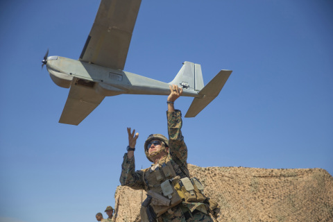
AeroVironment’s Puma is hand-launched. (Photo: Lance Cpl. Frank Cordoba/U.S. Marine Corps)
AeroVironment Inc. has introduced Puma VNS, a visual-based navigation system for its Puma 2 AE and Puma 3 AE small unmanned aircraft systems (SUAS). The system enables navigation across GPS-denied environments.
Puma VNS will receive frequent software and hardware updates, providing operators with advanced navigation capabilities, features and functionality. The system will also enable integration of future autonomy capabilities.
“Puma VNS gives operators an unprecedented advantage in the battlefield,” said Trace Stevenson, AeroVironment vice president and product line general manager for SUAS. “Operators now can execute missions with more confidence in GPS-contested environments with the system’s new navigational capabilities.”
VNS uses a suite of downward-looking sensors to gather imagery data and track features on the ground, as well as an embedded computing module to process and determine the precise location of an aircraft while in flight. The system automatically transitions to and from GPS-denied navigation mode without operator input.
Puma VNS is available as an add-on option for new Puma 3 AE system orders and as a retrofit kit for fielded Puma 2 AE and Puma 3 AE systems.
The Visual Navigation System improves navigation in GNSS-denied environments by means of visual odometry techniques
Photo: UAV Navigation
UAV Navigation has released its new Visual Navigation System (VNS), a new capability for manufacturers and end users of NATO Category I and II unmanned aerial systems (UAS).
The compact and lightweight device — provided as an optional peripheral to the main flight control system — enables the safe and efficient navigation of UAVs in GNSS-denied environments. The VNS combines visual odometry techniques and pattern identification with the rest of the sensors onboard the aircraft to ensure that the absolute position, orientation and relative movement of the aircraft over the ground is calculated with extremely high accuracy.
The planning and execution of UAV missions in environments in which the GNSS signal is either unavailable or unreliable is becoming more critical. For some missions, the datalink to the ground control station may be subject to interference, or the operation dictates that the flight must be performed without a datalink from the outset.
Under these circumstances, UAS traditionally rely on an inertial navigation system (INS) to complete the mission. However, all such inertial systems accumulate navigational drift due to sensor noise, propagation models and the difficulty in characterizing external forces. This positional error limits any such UAS operation because an accurate position cannot be guaranteed.
The new VNS, combined with the company’s Vector range of flight control systems, effectively addresses this problem by using data independent from GNSS and more accurate than INS. The system identifies patterns in the terrain below to assist in canceling out any accumulated error, allowing the UAS to operate for long periods without losing positional precision.
Because of its reduced size and weight, the VNS can be installed in Category I and II UAS, enabling them to take advantage of this navigation technique without penalizing autonomy or payload capacity.
The new VNS — developed entirely by the Spanish company UAV Navigation, part of the Oesía Group — has produced outstanding results during flight testing, both on fixed-wing platforms (typically with higher airspeeds and greater service ceilings) and rotary-wing platforms (where high vibrations and hover maneuvers are typically a problem). The new VNS has proved its ability to provide accurate navigation information for flights where there may be an intermittent loss of GNSS signal, and also when a flight must be executed from the outset without GNSS data.
A division of the U.S. Army Futures Command is conducting stratospheric experimentation using the Zephyr ultra-long endurance stratospheric unmanned aerial system (UAS). The tests are being carried out at Yuma Proving Ground in Arizona by he Assured Positioning, Navigation and Timing/Space (APNT/Space) Cross-Functional Team (CFT), which is based in Huntsville, Alabama.
The first flight of 2022, launched June 15, demonstrated Zephyr’s energy storage capacity, battery longevity, solar panel efficiency and station-keeping abilities that will further the army’s goal to implement ultra-long endurance stratospheric UAS capabilities.
During the flight, the Zephyr accomplished a number of firsts, including
first flight into international airspace
first flight over water
longest continuous flight utilizing satellite communication controls
the farthest demonstration from its launch point while carrying a commercial, off-the-shelf payload
breaking the world record for longest duration UAS flight (26 days) set by the same aircraft in 2018. This flight has completed 36 days and is still flying over Yuma Proving Ground.
“Ultra-long endurance unmanned platforms have the potential to provide significant military capabilities and enhanced confidence as part of the Army’s diversified multi-layered architecture,” said Michael Monteleone, director of the APNT/Space CFT. “We have seen incredible progress in high-altitude platforms in recent years. This experimentation allows us to build on that knowledge by demonstrating multiple payload types, fully exploring the military utility of stratospheric operations, and modernizing areas of deep sensing, long-range targeting and resilient communications.”
Zephyr is prepared for a flight test. (Photo: Airbus)
Upcoming Second Launch. A second Zephyr flight will launch in the coming weeks and travel over the Pacific Ocean. The flight will demonstrate a prototype payload, developed by the Army Futures Command, over multiple combatant commands, and continue to inform high-altitude requirements.
The Airbus-developed Zephyr is the first high-altitude UAS of its kind, providing a persistent and adaptable longevity in the stratosphere. The experiments are performed with cooperation of the Intelligence, Surveillance and Reconnaissance (ISR) Task Force, U.S. Army Program Executive Office – Aviation, and multiple combatant commands under an Other Transaction Authority (OTA), with T2S Solutions LLC as the integrator.
The APNT/Space CFT is responsible for accelerating the delivery of advanced APNT, tactical space and navigation warfare capabilities to the soldier. Working with a core team of experts, the CFT informs technology and system requirements through continuous experimentation and prototyping, technology integration and soldier feedback. Through this process, the APNT/Space CFT supports the Army Futures Command in delivering next-generation weapons, vehicles and equipment at an accelerated rate, giving Army forces the ability to deploy, fight and win decisively against any adversary, anytime and anywhere.
The 6th Unmanned and Autonomous Systems for Utilities & Energy Conference will take place in Atlanta, GA on June 8-9, 2022.
The event aims to provide a platform for UAS professionals to gain insight from industry peers and regulatory bodies on best practices in pilot training, safety in inspections, data management and security, updates on Part 107, new UAS technologies, and other key issues for utilities.
The conference also includes discussions on alternatives to foreign-made drones, BVLOS waivers and use cases, a closer look at LiDAR and AI, and building and refining drone programs to boost efficiency and reliability. Attendees will learn how they can navigate through industry challenges by leveraging emerging technologies and improving existing strategies to boost operational success.
Join the event to learn how you can navigate through industry challenges by leveraging emerging technologies and improving existing strategies to boost operational success.
Those who are unable to attend in person have the option to attend virtually. The Live+ content platform will give you access to all the presentations and is loaded with features to ensure full participation.
AUVSI members are entitled to a discount on full price conference fees (not valid for solution providers).
For registration information, cost and any discounts that may apply please contact:
Ria Kiayia
Digital Media & PR Marketing Executive [email protected]
DroneShield has begun releasing a software update across its counter-unmanned-aerial-system (C-UAS) devices, including portable, vehicle-based and fixed-site devices. The devices are used by the military, the intelligence community, U.S. Homeland Security, law enforcement, critical infrastructure and others.
The updates will be rolling out across DroneShield devices globally in the coming week, with heightened urgency given the widespread use of drones in Ukrainian and Middle Eastern conflicts. The technology upgrade is validated by deployments with the U.S. Air Force and Australian Army.
Enrolled devices receive quarterly firmware updates of the proprietary DroneShield RFAI artificial intelligence engine. Some of these updates are major enhancements, such as this 2Q22 release.
Major upgrades include:
Site Install Wizard. The new Spectrum Viewer mode, in which C-UAS detection devices scan the deployment area for optimal sensor placement
Machine Learning in the Loop. This option enhances the RFAI engine from the data received by the user.
Both features were added in response to end-user requirements.