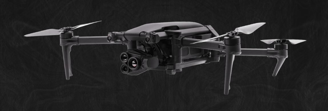
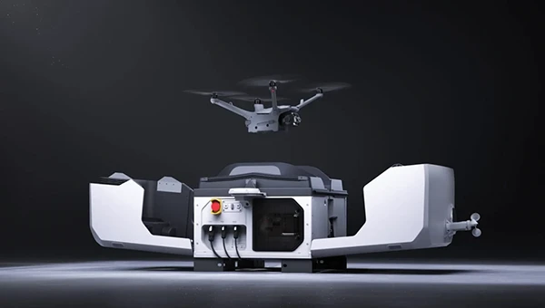
Ukraine has received its first Shark ultralight aircraft with electronic warfare (EW) capabilities from the Czech-Slovak company Shark.Aero, reports European Security and Technology (ES&T), a German publication. The Shark can detect and jam enemy drones and will strengthen the defense of Ukraine against Russian attacks.
The Shark’s two-seat tandem configuration was originally designed as a high-performance ultralight aircraft for civilian use. Its main features are its high speed of nearly 300 km/h and its maneuverability.
The military version of the ultralight is designed to detect and jam enemy drones. It offers the Ukrainian army a mobile, airborne defense option against loitering UAVs and reconnaissance drones.
Electronic warfare system
The first EW component suppresses GNSS navigation signals; the second suppresses video and remote control channels of enemy drones. The system is installed in a suspended container under the center of the fuselage so as not to affect the aerodynamics of the craft. From an altitude of 1800 m, the system can interfere with the operation of drones within a radius of up to 4.5 km.
A Shark representative discusses the ultralight with EW capabilities below.
Parrot has unveiled the Anafi UKR (Ukraine) range of compact defense micro-UAV drones at the Paris Air Show. The micro-UAVs are built to meet the critical demands of field operations, from defense theaters to public safety missions.
Developed for defense forces operating in high-threat environments, AnafiUKR brings together embedded AI, optical navigation, and full offline autonomy in a sub-1 kg format. Building on this foundation, Anafi UKR GOV adapts the platform’s capabilities to the needs of law enforcement, first responders and government agencies, ensuring the same level of resilience, tactical awareness, hardened cyber-resilience, and total data sovereignty.
“ANAFI UKR was born from the urgent need to defend a nation’s sovereignty and freedom. We’ve taken what we learned in high-intensity, GNSS-denied conflict zones, where drones are jammed, spoofed, and hunted, and turned it into a platform that public agencies can rely on. It’s the most advanced micro-UAV we’ve ever built: sovereign, powerful, and radically easy to use. When national security and civil protection overlap, as they increasingly do, agencies need tools that don’t compromise. ANAFI UKR is our response: the best of tactical autonomy, delivered in a micro-UAV that combines intuitive operation with advanced tactical capabilities.”
Henri Seydoux, founder and CEO of Parrot
Anafi UKR GOV is based on Parrot’s defense-grade micro-UAV deployed by several European, North American and NATO allied forces since mid-2024. Designed to remain fully operational in GNSS-denied environments and hostile electromagnetic conditions, the system integrates advanced optical navigation, anti-spoofing with frequency hopping military radio, and hardened cybersecurity architecture , all tested in live electronic warfare scenarios.
Anafi UKR and Anafi UKR GOV are both in full production and commercially available. Deliveries are ongoing to defense and institutional clients, and the systems are now open to order for all eligible public safety agencies, law enforcement units, and government users worldwide.
Representatives from 18 drone technology companies — including AgEagle Aerial Systems, uAvionix, BRINC, Kelly Hills and Pierce Aerospace — participated in a second high-level, invitation-only policy discussion with the White House, hosted by the Office of Information and Regulatory Affairs (OIRA). This most recent engagement was centered on the proposed FAA Rule Part 108, which will define the regulatory framework for beyond visual line of sight (BVLOS) drone operations across the United States.
The finalization of FAA Rule Part 108 is expected to replace the current piecemeal waiver-based system, providing a more predictable, scalable, and innovation-friendly regulatory environment.
Enactment of Part 108 would remove operational barriers, drive capital investment, and unlock next-generation drone technologies that enhance both commercial and public sector applications, explained AgEagle CEO Bill Irby.
“This follow-up invitation by OIRA reaffirms the strategic importance of expanding BVLOS operations for the domestic drone industry,” Irby said. “Thoughtful and timely rulemaking can accelerate innovation, improve safety and compliance, and strengthen the U.S. position as a global leader in drone technology. Of particular value was the discussion of how streamlined regulation will allow broader deployment of autonomous data solutions and open the door for increased economic activity.”
The engagement was made possible in part through the leadership and coordination of the Association for Uncrewed Vehicle Systems International (AUVSI) and the Commercial Drone Alliance (CDA), who played key roles in facilitating industry participation and ensuring productive dialogue between the private sector and federal stakeholders.
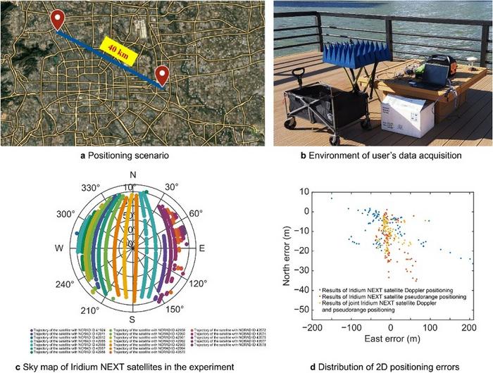
A novel method using signals of opportunity from low-Earth orbit (LEO) satellites is redefining what’s possible in satellite-based navigation. Researchers have developed a joint pseudo-range and Doppler positioning technique that taps into signals from constellations like Starlink and Iridium NEXT — without relying on traditional navigation signal structures.
By employing low-cost, wide-beam antennas and a specially designed time–frequency inversion algorithm, the team achieved remarkable accuracy: 3.6 meters in 2D and 6.2 meters in 3D, surpassing Starlink positioning approaches based on parabolic antennas by 35%.
Technical barriers in using signals of opportunity include signal transmission times, low signal power, and imprecise orbital data, all of which hinder accurate positioning. Addressing these challenges demands a new approach to extracting usable navigation data from LEO constellations.
In response, researchers from the Aerospace Information Research Institute introduced a joint pseudo-range and Doppler positioning method using wide-beam antennas to receive LEO satellite SOPs. The approach centers on a signal time–frequency inversion algorithm that reconstructs key signal parameters, alongside a novel accuracy metric called Equivalent Position Dilution of Precision (EPDOP).
Real-world experiments combining Starlink Doppler data and Iridium NEXT pseudo-range signals confirmed strong performance, especially in long-baseline conditions — reinforcing the method’s global applicability.
To overcome the cost and complexity of existing satellite tracking equipment, the team employed low-noise bock (LNB) wide-beam antennas capable of simultaneously receiving signals from multiple Starlink satellites. The core innovation lies in a signal processing algorithm that estimates transmission time and frequency from the received code phase and Doppler shifts — enabling both pseudo-range and Doppler observations without needing exact satellite clock data or real-time ephemeris.
To quantify system performance under real-world errors, the researchers developed the EPDOP metric, adapted to mixed measurement inputs. Tests demonstrated the method’s robustness: 3.6 m 2D and 6.2 m 3D positioning using Starlink Doppler signals, and up to 24 m (2D) and 41 m (3D) accuracy using Iridium NEXT SOPs over a 40 km baseline. Compared to Doppler positioning techniques, the algorithm reduced positioning errors by over one-third and successfully suppressed the impact of orbital inaccuracies inherent in public two-line element set (TLE) datasets.
“This work marks a key step toward accessible, accurate navigation using commercial satellite constellations,” said lead author Ying Xu. “By integrating Doppler and pseudo-range measurements and introducing a flexible precision metric, we can now harness Starlink and Iridium NEXT signals for high-precision positioning, even without access to proprietary signal structures. The proposed low-cost architecture opens new possibilities for resilient navigation in GPS-denied environments.”
Because of its ability to operate with low-cost antennas and weak, unstructured signals, the technique is poised to support a wide range of applications: from autonomous driving and unmanned aerial vehicle (UAV) navigation in remote regions to emergency response and IoT asset tracking. Its resilience to satellite orbital prediction errors and adaptability across different LEO constellations make it a strong contender for next-generation positioning systems. As LEO deployments continue to expand globally, this approach offers a scalable and practical solution for real-time, high-accuracy navigation—promising enhanced capabilities for both civilian infrastructure and defense operations.
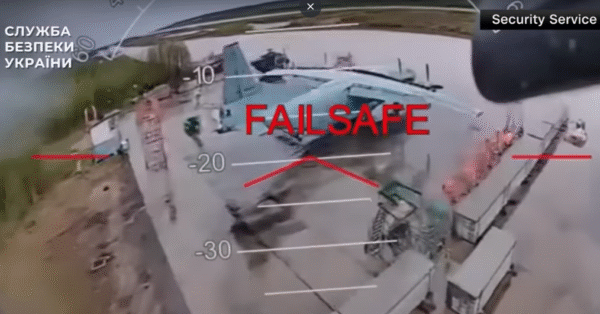
On June 1, 117 drones rose up from wooden boxes inside Russia and attacked bombers parked on runways at military bases. The attack — dubbed Operation Spider Web — startled the world with its audacity.
Approximately 41 planes were struck at four military bases, including the Belaya Air Base in Siberia hundreds of miles from Ukraine’s borders. In all, the attack destroyed a third of the bombers Russia uses as strategic cruise-missile carriers to destroy targets in Ukraine.
The drones were smuggled into Russia via commercial trucking transportation.
According to an analysis by Michael C. Horowitz for the Council on Foreign Relations, the strikes “once again demonstrated Ukraine’s ability to be at the cutting edge of technology and tactics. Ukraine has consistently and successfully leveraged and integrated everything from old military technology and off-the-shelf commercial systems to artificial intelligence (AI) for its military operations. This has been a difference maker in the war since its early days, giving Ukraine new and unexpected vectors to attack Russian forces and territory.”
The analysis, by Michael C. Horowitz, calls this a new era for warfare — the era of precise mass. “The combination of AI and autonomous weapons, precision guidance, and commercial manufacturing mean that low-cost precision strikes are now accessible to almost any state or militant group,” Horowitz writes.
The attack demonstrates that countries can be at risk to drone attacks even deep inside its borders, and precision strikes the capability of any actor. Low-cost off-the-shelf drones can be readily used, along with open-source autopilot software and AI code. Drones can supplement or even replace traditional artillery or expensive cruise missiles.
Read a roundup of recent products in the GNSS and inertial positioning industry from the April 2025 issue of GPS World magazine.
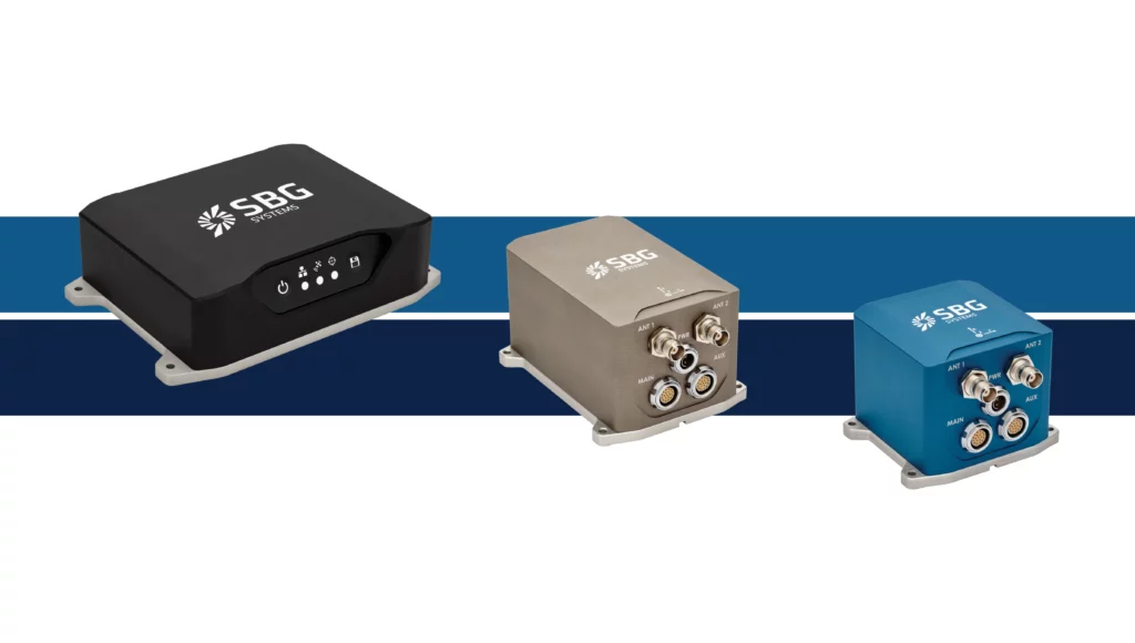
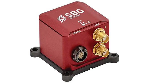
OEM
INS With three additional GNSS receiver variants
Photo: Topcon
SBG Systems has upgraded its inertial navigation systems — Ekinox, Apogee and Navsight — with new GNSS receiver options. The latest update introduces three additional GNSS receiver variants.
These include:
Marinestar, which supports Fugro Marinestar, delivering precise point positioning (PPP) with centimeter-level accuracy via L-band corrections without requiring a base station. It is optimized for marine applications.
HAS Ready / NavIC, which includes Galileo E6 support for the upcoming Galileo High Accuracy Service (HAS), offering free decimeter-level PPP corrections globally. Additionally, it supports the Indian NavIC system.
Centimeter-Level Augmentation Service, which is tailored for users in Japan; this variant utilizes QZSS L6 signals to provide free PPP corrections without external services.
All GNSS variants integrate seamlessly with SBG Systems’ antenna portfolio and Qinertia post-processing software. Users select the appropriate GNSS variant at purchase to match their operational requirements. These enhancements aim to provide versatile solutions across diverse industries while ensuring reliable performance.
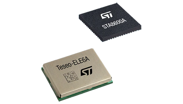
The GNSS receivers in the Teseo VI family use multi-constellation and quad-band signal processing on a single chip, achieving centimeter-level accuracy for various applications. The Teseo VI family includes the STA8600A and STA8610A models. These receivers are designed for automotive applications such as advanced driver assistance systems and autonomous driving, as well as industrial uses, including asset tracking, mobile robots and precision agriculture.
The Teseo VI+ variant can host enhanced positioning engines developed by third-party companies, providing real-time kinematics for centimeter position accuracy.
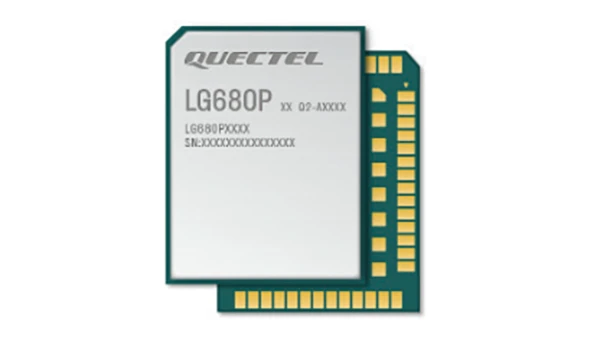
The LG680P is a multi-constellation, quad-band GNSS module designed for high-precision positioning and to enhance signal quality and precision through concurrent reception of L1, L2 and L5 frequency bands. It supports Galileo E6, QZSS L6 and BDS B2b signals for precise point positioning, ensuring horizontal accuracy of up to 0.8 cm + 1 ppm without requiring local or broadband connectivity.
To ensure signal integrity in environments with electromagnetic interference, the module features professional-grade anti-jamming technology, including built-in NIC algorithms that suppress narrow-band interference. It supports external active antennas for enhanced signal reception and positioning accuracy. It is ideal for applications such as autonomous lawnmowers, delivery robots, surveying equipment and precision agriculture. Quectel complements it with two external GNSS antennas: the YEGR001W8AH geodetic antenna and the YEGD006U1A compact patch antenna.
The New Ellipse firmware upgrade for the Ellipse product line allows the system to now be used as an attitude and heading reference system or inertial navigation system. It is designed to enhance navigation, attitude and heave performance for stable and accurate positioning, even in challenging conditions.
It introduces advanced GNSS-denied capabilities, featuring newly integrated flags that trigger when GNSS jamming or spoofing threats are detected. This allows users to reject or re-enable external sensors — such as GNSS — without resetting the filter. The user-friendly interface allows for fast and flexible configuration using simple command lines, enabling users to tailor the Ellipse to their specific needs and applications.
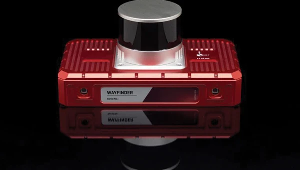
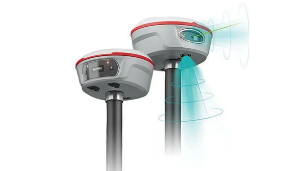
Localization Solution Operates in GNSS-denied environments
Photo: OxTS
WayFinder is a localization solution designed for GNSS-denied environments. It integrates a GNSS/INS system, onboard processor, lidar scanner and two cameras, enabling precise navigation in areas with limited satellite coverage. The system features Lidar Boost, a software technology that enhances GNSS/INS performance by processing lidar data to compensate for missing or inaccurate GNSS updates in real time. This ensures high-accuracy localization and seamless transitions between GNSS-supported and GNSS-denied environments.
WayFinder enables precise navigation for autonomous vehicles in ports, mining and indoor automotive testing without fixed infrastructure. It also provides reliable positioning for surveyors in areas with limited GNSS coverage.
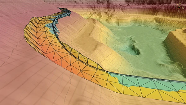
Virtual Surveyor Version 10 introduces Basic Topographic Design tools, allowing users to document terrain changes such as graded roads, water ponds and building surfaces. The software now features four subscription plans — Valley, Ridge, Mountain and Peak.
Ridge plan: Focuses on surveying a single moment in time using one drone data set.
Mountain plan: Adds Timelines to compare surveys across different times, visualizing changes through Time Steps.
Peak plan: Includes advanced Topographic Design tools for planning future structures by creating new Time Steps. These tools allow users to design features such as roads or ponds directly on UAV-derived models, with automated alignment and volume calculations for cut-and-fill operations.
Version 10 introduces drawing guides, available in the Ridge plan and above, enabling precise drawing of points at specific intervals or angles. Walk Mode, included in all plans, allows users to explore 3D terrain at ground level for better visualization. Timelines, featured in the Mountain and Peak plans, facilitate the comparison of multiple surveys conducted at different times and the integration of future designs. These improvements seek to streamline processes for engineering surveyors, supporting applications in construction, mining and water management.
The Jupiter Laser RTK integrates GNSS, auto-IMU, laser and dual camera systems into a single unit. It incorporates a precise green laser that remains visible even in bright daylight. This feature allows for precise measurements of points in hard-to-reach, signal-blocked or potentially hazardous locations. It also features a night vision camera, allowing users to see feature points even in low-light conditions. The RTK system’s laser range is up to 50 m, making it suitable for challenging surveying environments. It incorporates visual technology to offer surveyors an immersive experience during surveying and stakeout operations, improving working efficiency and productivity.
Version 2.1.0 of AgEagle Aerial Systems’ eBee VISION application software introduces circular and grid mapping features, allowing users to generate 2D or 3D maps using external post-processing software for more comprehensive geospatial data.
The eBee VISION 2.1.0 can continue missions in GNSS-denied environments and allows manual deactivation of GNSS to prevent jamming or spoofing. It implements the STANAG 4609 standard, the official format for motion imagery exchange within the NATO nations. This involves embedding UAV position and camera information into the videos recorded by the UAV and those broadcasted by the Ground Control Station. Its inclusion in the system seeks to enhance interoperability with third-party applications, which is key for military-grade UAVs.
It offers enhanced control over the Silent Tactical Landing feature. Users can now manually adjust the landing position on the map, with the system providing range estimates to inform operators of the UAV’s reach. This functionality offers greater flexibility in mission planning and execution, particularly in tactical scenarios requiring precise landing control. The system is ideal for defense, public safety and utilities applications.
‘Drone-in-a-Box’ Solution Designed for vehicle-mounted deployments
Photo: DJI
The DJI Dock 3 “drone-in-a-box” solution is designed for vehicle-mounted deployments and 24/7 remote operations in various environments. This system is compatible with the Matrice 4D and Matrice 4TD UAVs, which feature advanced cameras and IP-rated protection for challenging conditions. The UAVs are ideal for public safety, emergency response and infrastructure inspection.
This system supports flexible deployment options, including vehicle-mounted setups optimized for emergency operations and long-distance inspections. It enables horizontal calibration and cloud-based dock location adjustments. Two docks can be mounted on a single vehicle to facilitate dual-UAV rotations for enhanced efficiency. In fixed deployments, the D-RTK 3 Relay Fixed Deployment Version can be added to improve video transmission and satellite connectivity.
The Matrice 4D and 4TD UAVs have a wide-angle camera, medium tele camera, tele camera and laser range finder. The Matrice 4D features an advanced camera suite designed for high-precision mapping. The Matrice 4TD includes an infrared thermal camera for public safety and emergency response applications. The system includes a Flight Termination System to support regulatory compliance in strictly controlled airspace. This system can manually or automatically stop drone operations if necessary.
Casia G Release 4.0 is a software update that enables nighttime detection of aircraft, allowing 24/7 beyond visual line of sight (BVLOS) UAS operations. The update supports BVLOS flights up to 400 ft at night without requiring hardware modifications, offering detection of both cooperative and non-cooperative aircraft. The system detects aircraft at distances of up to 16.7 km with 360° coverage, ensuring safe nighttime operations. When multiple units are used, triangulation technology provides accurate range, altitude and satellite data for intruding aircraft. The update leverages existing hardware to detect navigation and anti-collision lights at night.
The MAS10 is a 77 GHz FMCW marine radar system designed to enhance navigation safety in congested environments under all weather conditions. The ultra-high-definition W-band radar provides centimeter-level resolution, enabling vessels to detect and identify small hazards in heavily trafficked waterways.
Unlike optical and infrared sensors, W-band radar technology penetrates fog, heavy rain and snow, ensuring reliable detection. It operates effectively in low-visibility scenarios, including complete darkness, intense sunlight and shadowed areas where cameras and lidar may struggle.
The Eagle Series line of spatial 3D scanners feature lidar and imaging sensors and are designed for various applications, including reverse engineering, digital twinning, asset management, extended reality, precision mapping and 3D printing.
The series offers scanning capabilities with a range of up to 140 m and precision within 2 cm at 10 m. The lightweight scanner is designed for portability, with a built-in battery providing up to one hour of continuous use.
The scanners are available in Standard and Max versions. The Max model features four 48 MP cameras, enhancing scanning efficiency and producing vivid 8 K panoramic photos. With a point cloud frequency of 200,000 points per second, the Eagle Series is designed for applications requiring highly detailed spatial data.
Upgraded Mapping Package With Google Maps downloads
Photo: Golden Software
Golden Software has upgraded its Surfer mapping and 3D visualization software. Users can now directly download georeferenced aerial and satellite imagery from Google Maps into projects. The latest version also improves 3D visualization tools, focusing on faster and more intuitive creation of visual models. Users can now colorize 3D drill hole intervals based on text keywords, making it easier to interpret subsurface data. Additionally, contour slices can now be added to the 3D view, offering a clearer representation of data layers.
Golden Software has released a beta version (30.0.135) that introduces multiple light sources for improved 3D viewing and customizable legends for better map presentation. These updates are designed to streamline workflows for professionals in industries such as environmental consulting, resource exploration and geospatial analysis, simplifying the creation of professional-grade maps and models efficiently.
savvy navvy has partnered with ProtectedSeas to bring ProtectedSeas Navigator data to boaters through the savvy navvy app.
After eight years of research and development, boaters and watersport users worldwide can now have access to comprehensive data and resources of ocean regulatory information, including marine protection areas, through the savvy navvy app.
ProtectedSeas Navigator provides boaters with 22,000 marine protected and managed areas in more than 220 countries. These areas include speed-limit zones to protect marine mammals, fisheries management areas and more.
ProtectedSeas compiles marine protection information into the Navigator database of marine protected areas (MPAs). It collects both large and small amounts of data and created the first public digital maps for more than 2,400 areas.
savvy navvy – often referred to as ‘Google Maps for boats’ – is an award-winning boat navigation app. It integrates multiple sustainable data sources from different conservation agencies and bodies.
Since launching its first global view of marine life protections, ProtectedSeas has been complimented by several industry-renowned leaders and bodies, including the U.S. National Oceanic and Atmospheric Administration (NOAA), Dr. Sylvia Earle, American marine biologist and oceanographer, and Gavin Newsom, governor of California.
Some ProtectedSeas data is already available in the savvy navvy app, with more to follow soon. Click here to learn more about the sustainable data or to download the app.
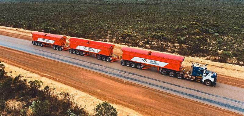
Hexagon has partnered with Mineral Resources (MinRes) to provide an autonomous haulage solution for a fleet of 120 fully autonomous road trains in Australia. The company says this will transform safety, productivity and sustainability in the region.
The fully autonomous road trains are a full-site, truck-agnostic solution. The addition of unmanned and autonomous systems will form an essential part of the supply chain for the MinRes Onslow Iron project in Western Australia’s Pilbara region.
The center of the autonomous platooning system is Hexagon’s autonomous solutions stack integrating drive-by-wire technology with an autonomous management system to orchestrate vehicle movement in road train haulage.
“Today’s agreement with MinRes will ensure that off-road transport activities will be safer, more sustainable, and more productive,” Paolo Guglielmini, president and CEO of Hexagon, said. “I’m excited to see how similar solutions can be applied in other off-road markets such as agriculture and heavy industry.”
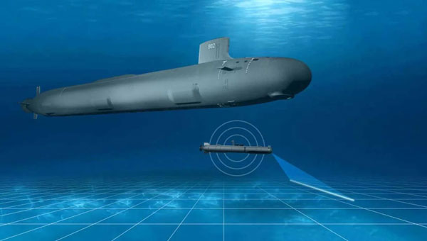
L3Harris has completed a fully autonomous launch and recovery of an autonomous underwater vehicle (AUV) from an underway submarine, referred to as Torpedo Tube Launch and Recovery (TTL&R). The launch used Iver4 AUV technology from L3Harris.
The L3Harris team worked closely with the U.S. Navy to demonstrate AUV launch and recovery through a test program aboard submarines and Navy support vessels.
The recovery of AUVs into an underway submarine allows the host platform to remain covert while the AUV performs surveys and missions in areas inaccessible to the host platform. The AUVs return with data that can be used for tactical and navigational planning — delivering manned and unmanned teaming to a fleet.
According to L3Harris, the company welcomes the continued opportunity to support the Navy in the development of manned and unmanned operational concepts. This capability will increase operational effectiveness and allow SSN-class submarines to serve as an AUV mothership.
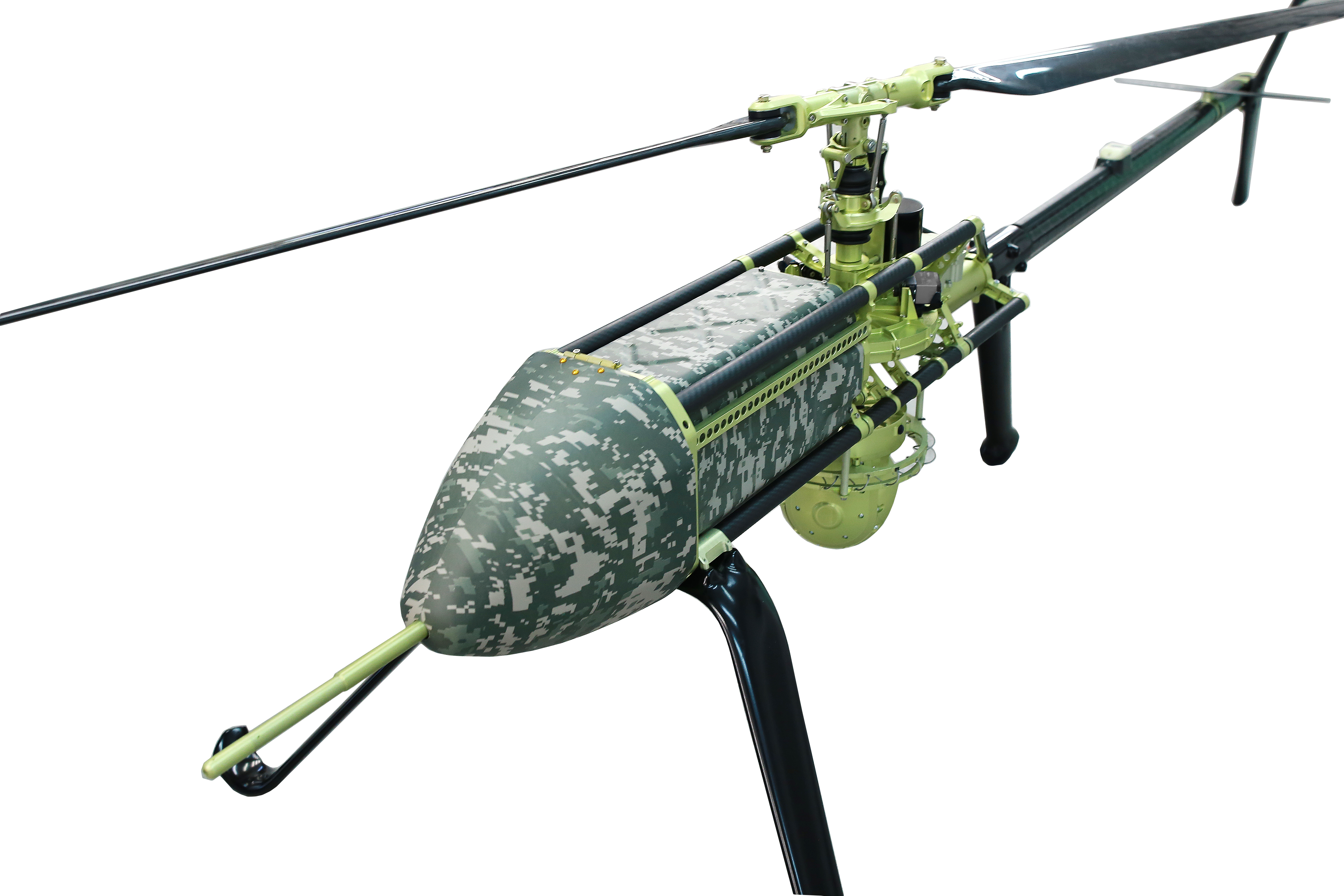
UAVOS has been selected by Bayanat, a provider of artificial intelligence-powered geospatial solutions, to deliver its unmanned aircraft system (UAS) for a variety of applications, including aerial photography and perimeter control. The UAS consists of two UVH 25EL unmanned autonomous helicopters powered by electric motors, a ground control station, and various sensor payloads — including a multispectral camera, lidar, and digital and thermal cameras.
The autonomous helicopter’s advanced capabilities of long endurance — up to 1.5-hours — along with its camera capabilities, enable the UVH 25EL to carry out accurate mapping within a radius of 67 km.
The UVH 25EL has a practical load weight of 5 kg. These capabilities enable high performance as well as maximum operational flexibility for applications such as coastal security, search and rescue, and advanced aerial photography missions.
UAVOS also provides full operational support, including training, and a fundamental review of the UAS’s possible uses.
Airbus Helicopters and the French Armament General Directorate (DGA) tested the unmanned aerial system (UAS) VSR700 for the first time in an operational configuration from a ship at sea.
The VSR700 performed 80 fully autonomous take-offs and landings from a civil vessel off the coast of Brittany in the west of France at the beginning of May.
In 2022, the autonomous take-off and landing capabilities of the VSR700 were tested from the same vessel using an optionally piloted vehicle based on a modified Guimbal Cabri G2 equipped with the autonomous take-off and landing (ATOL) system, developed for the VSR700. This time the test campaign took place with the SDAM demonstrator and fully validated the capabilities of the system as part of the Système de Drone Aérien pour la Marine study that was awarded to Airbus Helicopters and Naval Group in 2017.
Autonomous take-off and landing capabilities are a key asset of the VSR700 and are made possible with the use of the Airbus DeckFinder system. This enables autonomous launch and recovery of UAVs with an accuracy of 10cm-20cm during challenging operations in harsh environmental conditions, independently of GNSS/GPS and regardless of degraded visual conditions.
This test campaign follows two series of trials that were conducted with the DGA in late 2022 and early 2023, from the Levant Island test center located in the south of France. During these trials, the SDAM prototype demonstrated its ability to operate in a maritime environment.
The handling qualities of the aircraft were tested as well as the capabilities of the sensors (a maritime surveillance radar, an electro optical sensor, and an AIS receiver) alongside the mission system developed by Naval Group.
The next development steps will see the second VSR700 prototype perform its maiden flight ahead of flight testing onboard a French Navy FREMM during the second semester of this year.
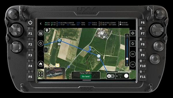
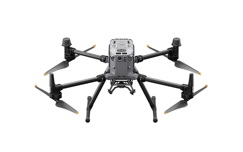
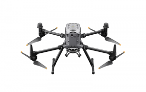
Frontier Precision has announced the availability of an upgraded flagship UAV platform, the Matrice 350 RTK.
This UAV platform features a new video transmission system and control experience, an efficient battery system, and more comprehensive safety features. It also offers robust payload and expansion capabilities.
The Matrice 350 RTK has a 55-minute max flight time and an IP55 rating. It features six-directional sensing and positioning, as well as a night-vision FPV camera, and 400 battery cycles.