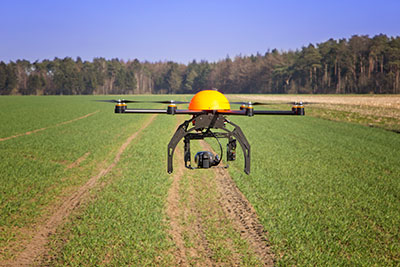
DroneMetrex has captured high-quality near-infrared (NIR) mapping data with its TopoDrone-100 UAV. DroneMetrex said in a news release that this is the first time such high quality NIR imagery has been captured by a UAV.
High-quality NIR data is a tool to detect chlorophyll. Because chlorophyll is emitted by all vegetation to various degrees, experts from land and forest departments, agronomists, vignerons and pastoralists will be able to discriminate between health and vigor of vegetation and between different types of vegetation. The data collected helps determine vegetation stress, disease, pest infection, irrigation faults and nutrient variations.
“We say ‘unique high-quality mapping’ because the data are both radiometrically and geometrically unparalleled from a drone,” said Thomas Tadrowski, managing director of DroneMetrex. “From the one-flight sortie, TopoDrone-100 users are able to perform vegetation analysis mapping as well as accurate 3D contours/DTM mapping. The pixel resolution is unsurpassed. The data geometry is unsurpassed. The radiometric mapping is unsurpassed.”
DroneMetrex offers its Extended Spectrum Mapping (ESM) camera modification as an option with the TopoDrone-100. After ESM modification, the camera is supplied with three external screw-on lens filters. Simultaneously using the NIR filter and a high-accuracy L1/L2/L5/GLONASS/COMPASS (BeiDou-2) PPK direct georeferencing solution, the TopoDrone-100 captures three-band imagery, with the near-infrared band recording unparalleled radiometric quality and chlorophyll discrimination.
The high radiometric quality is achieved because DroneMetrex specialists perform the necessary camera modifications themselves, and have designed the external filters specifically to match the requirements of accurate, discriminative vegetation mapping, DroneMetrex said.
Optech will be exhibiting its latest lidar and imaging solutions at the Unmanned Systems 2015 Conference in Atlanta, Ga., May 4-7, at the Teledyne Booth 2311. Optech’s solutions include a fully implemented lidar/camera workflow for UAV operations, as well as other airborne, mobile and stationary sensors.
Visitors can drop by the booth to learn more about Optech’s UAV solution, which combines the rugged Optech ILRIS terrestrial laser scanner and the new Optech XR6 photogrammetry small UAV with an integrated software workflow. The solution merges aerial camera imagery from the UAV with high-resolution data from Optech lidar to deliver comprehensive, georeferenced and highly accurate 3D planimetric data. The ILRIS lidar system can also be operated remotely through a web interface.
For advances in airborne sensing and surveillance using mid-size to larger UAVs, Optech will discuss the features of the compact Optech Galaxy lidar system and its PulseTRAK technology, which ensures a continuous operating envelope and steady point density even in rugged terrain, vastly simplifying mission planning, and eliminating “blind zones” — overcoming a long-standing limitation inherent to lidar sensors lacking PulseTRAK technology. Galaxy is compatible with all Optech mounts for integrating digital metric cameras, enabling clients to customize their solution with the right mix of LiDAR, multispectral, LWIR, MWIR and RGB sensors for their application.
Optech will also be showcasing the Optech Titan, a commercial multispectral airborne lidar, which accomplishes highly automated land classification using its separate 532, 1064 and 1550 nm laser channels, and performs combined topographic/bathymetric mapping down to a depth of 15 meters in clear conditions.
Visitors who need rapid coastal monitoring and object detection will be particularly interested in the new Optech CZMIL Nova, Optech’s upgrade of the award-winning CZMIL airborne bathymetric mapper. CZMIL Nova maintains its predecessor’s sensing power, including its unmatched turbid water penetration, while boosting installation flexibility and cost savings with a more efficient laser and much lighter hardware, facilitating operation in smaller aircraft.
UAV Solutions will display its new fixed-wing unmanned aerial systems (UAS) at AUVSI’s Unmanned Systems 2015 show, to be held May 5-7 in Atlanta.
In booth 1109 the company will introduce the Talon 120LE, a lightweight hand-launched air vehicle, and the Sidewinder, a high altitude, multi-fuel, intelligence, surveillance and reconnaissance (ISR) asset. The Intruder UAS, a multiple intelligence gathering platform with a gross take-off weight of 850 pounds, will be located in booth 2303.
With a wingspan of 12.5 feet, the Talon 120LE is a 16-pound electric UAS that may fly for nearly 2.5 hours. The system was created with open architecture software and hardware components for future flexibility. The company recommends the Talon 120LE for inspecting crops, surveilling power lines or conducting search and rescue missions. Its payload capacity is 2.5 pounds.
The jet powered Sidewinder UAS flies at high altitudes and operates in a low vibration environment ideal for ISR payloads. The Sidewinder can use various heavy fuels including diesel, kerosene and Jet A. It has a wingspan of 16 feet and a payload capacity of 10 pounds.
UAV Solutions’ new Intruder is capable of operating at higher density altitudes. It also is able to collect information via satellite communication, signals intelligence, communications intelligence and imagery intelligence. It has retractable landing gear, and the agnostic center-of-gravity mounted payload location accommodates up to 100 pounds.
Along with the UAS the company is showing, it also will feature its multi rotor UAS — Phoenix 60, Phoenix 30 and Phoenix 15 – as well as the Dragon View camera sensor.
Dragon View sensors can be integrated onto unmanned aerial vehicles (UAVs), antenna towers, buildings or other structures to provide day and thermal imagery, video recordings, object tracking and geolocation data. The sensors are lightweight, mechanically and digitally stabilized gimbals with electro-optical and infrared cameras.
They also can easily be mounted onto UAVs, antenna towers and other structures for police organizations.
Skip Miller, UASUSA’s founder and CEO, stands with with the Tempest ET.
UASUSA will unveil its payload advancements in booth 631 at AUVSI’s Unmanned Systems 2015, held May 5-7 in Atlanta.
The new Trimble RTK high-accuracy GPS positioning system will be available through UASUSA. It covers up to 2,300 acres per flight for photo mosaic and mapping missions with manufacturer specified sub-centimeter accuracy.
UASUSA also modified its leading aircraft, the Tempest, to create the Tempest ET. The new aircraft has added payload storage interchangeable in the wing tip extensions, yet still offers the same level of stability, endurance, efficiency and aesthetics as the Tempest, UASUSA said.
The Tempest ET is designed for magnetometer use in the mining industry and offers interchangeable regular, extended and payload tips. With its 10- to 15-pound payload capacity, it may carry the Phoenix Aerial LiDAR system to cover large areas and create survey-grade point clouds.
DroneDeploy, a start-up provider of cloud-based software solutions for commercial drone operations, has launched its mobile app. The app automates drones and receive real-time, reliable, detailed aerial maps and images. Also, through a partnership with DJI, DroneDeploy’s software is now offered on the DJI Phantom 2 Vision+, making it available to end users in agriculture, real estate, mining, construction and other commercial and consumer industries.
DroneDeploy’s new mobile software lets users control drones and cameras while in flight, and is the first solution to process data, information and visuals in real-time. The solution makes simple, real-time mapping, with guaranteed accuracy and one-click automated results, available anytime, anywhere.
“DroneDeploy has created a custom mobile application for the DJI Phantom 2 Vision+ that provides a remarkable live mapping platform, autonomous flight, and aerial data capture capabilities,” said Eric Cheng, general manager, DJI San Francisco and director of aerial imaging, DJI. “We are proud to partner with DroneDeploy, and are excited about the future of autonomous aerial imaging platforms.”
Using the DroneDeploy app, farmers and agronomists can now quickly assess and diagnose crop health, detect field variations, categorize yield zones and analyze NDVI outputs for smarter farming decisions. Construction and mining operators can easily generate high-resolution 3D or digital elevation models of sites and structures, and analyze plan progress to eliminate inconsistencies.
“The introduction of our mobile application marks a first in the adoption of drones for commercial use. DroneDeploy makes it possible for users without any training to access and employ drone-based aerial imagery and mapping. Our mobile app is faster, more affordable, easier and more accessible than any other solution on the market today,” said Mike Winn, DroneDeploy’s co-founder and CEO.
DroneDeploy will be exhibiting at booth 2048 at the AUVSI’s Unmanned Systems 2015, held May 5-7 in Atlanta.
INTERGEO 2015 will offer a new Interaerial Solutions hub in Hall 8 of Messe Stuttgart in response to the rapid development of the unmanned aerial systems (UAS) market sector. The hub, or platform, includes a forum and a flight zone in a designated outdoor area. INTERGEO 2015 takes place Sept. 15-17 in Stuttgart, Germany.
“Compared to the presentations at INTERGEO 2010 alone, the proportion of UAS manufacturers and service providers from this sector grew continuously to over 10 percent of exhibitors in 2014. Our Interaerial Solutions platform provides a clearly structured showcase for visitors and users,” said Olaf Freier, CEO of INTERGEO organizer HINTE GmbH.
The Interaerial Solutions hub is a response to the rapid development in data acquisition, analysis and applications for unmanned flight systems. The new partnership with the German-speaking Unmanned Aircraft Vehicle Association — UAV Dach — underlines INTERGEO’s commitment to remaining the leading trade fair in the German-speaking region for UAS manufacturers and service providers, organizers said.
INTERGEO was the largest UAS trade fair in the German-speaking region in 2014, with around 70 manufacturers of unmanned aerial systems (UAS) and service providers offering UAS-based applications.
Great view of the Pentagon while departing from the U.S. Hydro conference held in Washington, D.C.
I’ve attended five conferences in the past couple of months; Esri Water Conference (first one!), Esri Partner Conference, US Hydro 2015, APSG (Association of Petroleum Surveying & Geomatics) and the Esri Petroleum User Group (PUG) conference. It may look Esri-heavy, but the fact is that Esri is doing a really good job of organizing vertical market GIS conferences, and people are showing up. Even with crude oil prices in the cellar (relatively speaking), 1,200 people still showed up at the PUG.
There were a lot of good presentations at these conferences, and I’ll post links to some of them below. Not surprisingly, drones are a major topic of discussion at most GIS conferences. There was even a drone demo (I missed) at the Esri Partner conference showing Esri’s workflow in working with drone-collected data.
If you don’t follow me on Twitter, you might consider it. Twitter is easy and free. When I’m at a conference, I send tweets (most with a photo) in near real-time when I see something of interest. For example, I tweeted when Jack Dangermond showed up at the Esri PUG (he usually doesn’t, but did this year because it was the 25th annual conference) and had something interesting to say (read below). You can sign up for Twitter here, and then choose to follow me at https://twitter.com/GPSGIS_Eric. I get that you may be hesitant to invest any time in this, but it looks like Twitter is becoming the standard for near real-time news (as opposed to other social media such as Facebook or LinkedIn.)
Of all the new technology I’ve heard about over the past few months at these conferences, two subjects continue to excite me.
Drone Mapping. Of course, one of them is drone technology for mapping. It seems like I’ve beat this horse to death over the past few months, but it continues to get juicier and juicier. Technology development in this industry is moving really fast. It seems like new drones are being announced as frequently as new smartphones, maybe more so.
Other ancillary technologies are being developed to support commercial drone operations. For example, in my hometown (Portland, Ore.), a company called Skyward just raised $4+ million in venture capital funding to provide “professional services for UAV operations.” Essentially, the company’s software helps drone operators stay within FAA regulatory compliance.
Last year, the Oregon Unmanned Systems Business Enterprise was formed “with a two-year $882,000 state grant from the Oregon Business Development Department and the Oregon Innovation Council and will be working to match the government money with private investment and other grants.” The organization will award grants up to $75,000. The point is, the money is flowing and it’s a wide-open market.
The drone market is so wide open, in fact, that most drone companies are just buying common airframes and associated parts, putting their brand name on them, and selling them. Perhaps oversimplified, but the point is there’s not much “special sauce” (technology) being added. The manufacturers that aren’t innovating and adding valuable “special sauce” will eventually disappear. Essentially, following are the parts needed for a fixed-wing drone for mapping:
Aircraft components:
Airframe (off the shelf)
Motor (off the shelf)
Servos (off the shelf)
Propeller (off the shelf)
Radio (off the shelf)
GPS (off the shelf)
Autopilot (off the shelf)
Batteries (off the shelf)
Camera trigger (off the shelf)
Camera (off the shelf)
Ground compoments:
900-MHz controller (off the shelf)
Battery chargers (off the shelf)
Mission planning software (off the shelf)
Propeller balancer (off the shelf)
As you can see, all of these components are available off the shelf. You can order each component (maybe all of them from Amazon!), have them shipped to you, and assemble your own UAS for mapping. That said, someone who has gone through the process of building, flying and producing a valuable deliverable that you can make decisions from can add value. But, as competition increases, there’s no doubt that the companies that don’t offer much added value will not be able to operate a sustainable business.
Finally, the U.S. Federal Aviation Administration (FAA) is being surprisingly nimble, approving “333 Exemption” requests at record pace and moving towards using a “summary grant” process to issue bulk approvals of 333 Exemption requests for commercial operations.
UAS presentation from Texas A&M University, one of six FAA-designated UAS test sites.
You may want to take a look at some of the other presentations at the APSG meeting. They were very good. Here’s a quick summary of each by Jon Stigant, long-time member of APSG:
This was a primer in LiDAR technology and methodology — while most of the paper is well understood in the survey community, it is and excellent overview. A reminder for some and a way to fill in the gaps for those not so close to this technology.
Integration of UAVs into O&G Operations — Stacey Lyle, BP (presentation forthcoming)
Stacey provided a valuable summary of the direction in which the FAA is going to regulate the emerging UAV technology. A “must read” for any company that intends to either provide or use this technology. As with most government regulation there is a lot of detail, the devil is in them. Stacey recommended that the APSG engage by developing some standards for the oil and gas industry.
Ron Hughes theme is massive data and managing it — also something of a common theme for all the talks. He focused on automating data processing and recommended a concept of doing this in an automated way with 80 percent of the data. This requires careful procedural development in collaboration with a given client’s business workflows. He gave an example of a large utility company, and how the development of an enterprise metadata server had functional impact for individual business units, but also had the knock on impact of improving inter-functional/inter-community collaboration within the enterprise.
Mike provided input on Geiger mode LiDAR, differentiating Harris’ approach from the more regular LiDAR methodology. The major difference is in data density, data frequency, volume and speed used from higher flying aircraft covering a larger area faster. Providing 10-cm accuracy and expecting 7-cm acuracy development using a/c at 25,000-ft height. Focus on fast processing of immense data volumes (pedabytes) – 24-hour delivery using Harris proprietary processing. Achieve higher density at lower cost.
Mark introduced developments in GIS associated with Common Operating Picture (COP), focusing on the combining of video and data in GIS system. DPFOS mnemonic: Data Management, Planning & Analysis, Field Mobility, Operational Awareness, Stakeholder Engagement. A new SIMOPS (SIMultaneous OperationS). The key is a single source of approved data. Examples of data required in COP from specific disciplines are provided — ROVs, shore clean-up, life of field data, asset and material tracking, live/recorded video, RT data and weather integration, “in the field’” vessel implementation.
GIS, Geospatial, Geomatics…Organizational Capability Evolution — Brian Boulmay, BP (presentation forthcoming)
Rethinking Geospatial Data Management at a major operator. One Map program — not physical, one-way provision. Focus on users vs. geospatial specialists. Users business driven, specialists IT and S driven. Geospatial data integrity and analytics – people, processes and technology. ID goals — massive deployment worldwide — has to be automated. Federated system — regions only have to deal with their own regional data, not be overwhelmed by whole enterprise on their doorstep. IT has the role of providing/maintaining a worldwide solution.
Update on Spring 2014 APSG meeting — All major networks launching satellites. Very soon will have 30 live in-view satellites (U.S., Russia, Europe and China). RTK coverage in China is the best due to BeiDou, supplemented by both Indian and Japanese systems SBAS. $100 RTK on cell phone giving centimeter accuracy eventually, and changing the commercial dynamic!
Set up for managing and analyzing LiDAR data in Global Mapper. Workflows: terrain modeling, visibility, biomass (change monitoring); asset: inspect and maintain pipelines, as-built modeling, simulation. High-accuracy at relatively low cost, outpacing regulatory management. Much public data available — earthexplorer.usgs.gov. xyz values — minimum height threshold, dense RGB point cloud (almost photographic).
Automated dashboard approach, reducing pilot distraction risk, speeding up RT transfer and operational activity reporting.
Esri Conferences
Here are a couple of neat things from the Esri conferences.
First, Jack Dangermond was his usual visionary self at the Esri PUG conference, making his appearance for the 25th annual PUG. He is a master at communicating his GIS vision.
The Evolution of GIS.
In speaking about the evolution of GIS, Mr. Dangermond spoke about the far-reaching impact of email and stated that eventually web-based GIS will be deployed organization-wide, just like email. I agree with this vision. I believe the only question is timing. Is it two years from now? Five years from now? 10 years?
Onto the less visionary and more tactical tidbits…
Of particular interest to me is high-precision GNSS in the Esri environment. A lot of people I talk to are screaming for this. What does high-precision GNSS in the Esri environment mean?
support for high-precision metadata in ArcGIS Collector (ArcPad already supports this).
support for high-precision horizontal (eventually vertical) datum transformations in ArcGIS Collector.
This is important because Esri is supporting ArcGIS Collector across all mobile platforms (Android, iOS and eventually Windows), and people want to use their smartphones and tablets. ArcPad will never run on iOS or Android, so Collector is the GIS collection tool of choice, at least for the Esri environment. It needs to support high-precision GNSS, and by the looks of the following slide, it will. It’s just a matter of timing…
ArcGIS Collector to support high-precision GNSS.
The other potentially neat product Esri announced was Navigator for ArcGIS. Imagine trying to guide a work crew to a buried valve across town (or in the next neighborhood). Displaying a system or region-wide map of valves would not be an efficient way of driving your way across town to find the valve. However, giving a crew turn-by-turn street directions to the street-level, then displaying the valves on that street section, might be a very efficient way of finding the valve.
Topcon Positioning Systems has received a national exemption from the Federal Aviation Administration (FAA) that allows for operation of its unmanned aerial system (UAS) in the United States. The exemption covers the operation of the Sirius Basic and Sirius Pro for aerial data collection.
The Sirius Pro and Sirius Basic systems are designed to produce accurate solutions for the automated mapping of a wide range of sites — regardless of terrain — including construction sites, mines and quarries. The UAS are designed for land surveying, transmission line and pipeline inspection, and agricultural operations such as field mapping and livestock management. With the Sirius Pro model, Topcon eliminates the need for ground-control points by combining real-time kinematic (RTK) GNSS solutions with precision timing technology to provide accurate mapping results, Topcon said.
“This exemption is exciting news for the U.S. marketplace,” said Eduardo Falcon, executive vice president and general manager of the Topcon GeoPositioning Solutions Group. “It allows Topcon to be a resource for end-users and provide UAS demonstrations and training. Aerial data collection has a strong impending impact on all the industries we serve, and the possibilities for survey, construction, and agricultural applications are seemingly limitless.
“Building on the success the Sirius models have already seen in the European and Australian markets, this exemption allows Topcon to expand on that momentum in the U.S.,” Falcon said.
With Exelis RangeVue, a high-performance GIS visualization engine provides real-time updates of critical operational elements.
Exelis has launched its first airspace situational awareness tool designed specifically for unmanned aerial system (UAS) operations in the United States. Symphony RangeVue puts real-time Federal Aviation Administration (FAA) surveillance data, flexible background maps and weather information in the hands of UAS operators and test range personnel. The system provides significant improvements to the safety and efficiency of UAS operations, whether on the test range or in the field.
Symphony RangeVue enables UAS operators and test range personnel to have access to both real-time and historical surveillance information via a web-hosted platform, helping to manage mission operations from multiple locations with full visibility of assets. Symphony RangeVue can be used as a command center decision-support and post-event analysis tool, or in the field as a sense-and-avoid addition to UAS ground control stations. Flexible geo-fencing tools alert operators when a UAS approaches airspace boundaries or when other aircraft are in the vicinity.
“For the first time, UAS operators and test range personnel will have the same situational awareness currently available to general aviation pilots through traffic information broadcast services. This capability is available without having to install avionics surveillance equipment on the UAS aircraft,” said Ed Sayadian, vice president of Civil and Aerospace Solutions for Exelis. “Leveraging the FAA’s own surveillance data combined with advanced sense-and-avoid alerting capabilities, Symphony RangeVue will significantly increase the safety of UAS operations.”
Symphony RangeVue combines a high-performance visualization engine with the vast network of Exelis NextGen surveillance data, including all of the FAA’s surveillance systems: automatic dependent surveillance-broadcast; en route radar; terminal radar; airport surface detection equipment-X; airport surface surveillance capability; and wide area multilateration. It also integrates locally deployed surveillance assets to deliver hyperlocal situational awareness.
ENSCO Inc. will display its unmanned aircraft systems (UAS) solutions in booth 1551 at AUVSI’s Unmanned Systems 2015 show, held May 5-7 in Atlanta.
Used primarily in military operations, ENSCO sees the value of UAS to law enforcement, agriculture, disaster evaluation and other civilian operations. The company is positioned to design, build, certify and support UAS in the National Airspace System based on its experience with the armed forces, the Federal Aviation Administration (FAA), and national security groups merged with its capabilities in avionics software and flight systems, PNT technology and weather forecasting.
ENSCO will demonstrate its Virtual ENvironment Operations Module (VENOM), a solution for training UAS pilots and payload operators. Fully configurable to match any UAS platform, sensor payload and mission, ENSCO says VENOM provides modeling- and simulation-based training capability based on open architecture and commercial technology.
Parrot’s quadcopter Bebop Drone has Furuno inside.
Furuno Electric Co.’s latest multi-GNSS receiver module, GN-87, has been adopted for the new quadcopter Bebop Drone, made by Parrot SA. Parrot develops advanced technology wireless products.
The GN-87 can receive GPS, GLONASS, SBAS, and QZSS concurrently, which significantly improves positioning success rate and robustness against interferences by using different frequency bands, Furuno said.
Parrot Bebop Drone, equipped with a 14-megapixel fisheye lens camera, takes video and pictures in a 180-degree field. The drone integrates mechanical and digital systems, like shock absorbers that cushion engine vibrations and algorithms for an exclusive 3-axis image stabilization, meaning that the angle of the view remains fixed, without distortion, regardless of the inclination of the drone and movement caused by turbulence. The combination of numerous sensors gives the drone impressive stability and great maneuverability when piloted via Wi-Fi with a smartphone and a tablet, or with its Wi-Fi extender, Parrot Skycontroller.
Furuno’s GN-87 supports sensing for autonomous flying according to flight routes preset on the map application by user, automatic return to takeoff position, recording flight path data for 3D modeling on Parrot Academy map. According to Parrot, selecting Furuno’s GN-87 multi-GNSS receiver module enabled simple integration with a high-performance GNSS receiver module while guaranteeing high quality and high volume supply availability.
The Association for Unmanned Vehicle Systems International (AUVSI) will host Unmanned Systems 2015, which will run from May 4-7 at the Georgia World Congress Center Atlanta. With 8,000 attendees from around the world, Unmanned Systems 2015 is the largest expo and trade show in the industry, according to AUVSI.
The event will include three days of interactive exhibits and exciting demonstrations of air and ground vehicles spread throughout 350,000 square feet of exhibit space. The 150-plus educational sessions, workshops, and panel presentations will focus on the future of commercial, humanitarian, environmental, governmental, and military applications for robotics and unmanned systems. For more information on the sessions, see AUVSI’s Program Planner.
This year’s conference will feature keynote addresses and panel discussions by:
Colin Guinn, chief robotics officer, 3D Robotics
Dave Vos, project lead, Project Wing @ GoogleX
David Vigilante, senior vice president, legal, CNN
Helen Greiner, CEO, CyPhy Works
Hugh Herr, MIT professor and head of biomechatroinics at the MIT Media Lab
Rep. Frank Lobiondo, New Jersey House of Representatives
Henrik I. Christensen, distinguished professor, KUKA chair of Robotics, and director of the Robotics & Intelligent Machines Center, Georgia Tech
For more information and a full agenda of events, visit www.auvsishow.org.