SBG Systems, a manufacturer of inertial navigation systems (INS), has selected the Septentrio AsteRx4 OEM GNSS receiver to equip its Apogee product line. The announcement was made during Ocean Business 2015, held April 14-16 in Southampton, England.
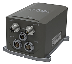
SBG Systems’ Apogee-D
“We are delighted that SBG Systems — a respected specialist in designing INS/GNSS — endorses our newly released GNSS receiver for its performance,” said, Laurent Le Thuaut, business development manager at Septentrio. “The SBG products are recognized amongst the preferred choice for accurate MEMS-based INS and we are extremely proud that our technology is included in their top of the line.”
Apogee is a new product line of high-accuracy inertial navigation systems based on robust and cost-effective MEMS technology. The INS/GNSS solution combines the latest generation of MEMS sensors and the OEM version of the AsteRx4, a newly introduced high-precision GNSS receiver from Septentrio. The Apogee series is especially suited for applications such as hydrography, mobile mapping and aerial survey where survey-grade positioning measurements are required.
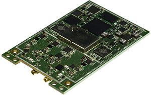
AsteRx4 OEM
The AsteRx4 OEM is a multi-frequency and multi-constellation dual antenna receiver that incorporates the latest innovative GNSS tracking and positioning algorithms from Septentrio. The AsteRx4 is scalable to one centimeter and integrates the entire suite of GNSS+ algorithms proposed by Septentrio to maintain tracking during heavy vibration of machines. This assures position accuracy under difficult ionosphere conditions and mitigates or rejects intentional or unintentional interference with GNSS signals.
“The compact design and the practical and well-designed interface of the AsteRx4 allowed a seamless and an easy integration into our solutions” said Raphaël Siryani, chief marketing & sales officer of SBG Systems. “The AsteRx4 largely contributes to the robust and accurate heading as well as the reduced power consumption of the INS/GNSS Apogee products.”
Both the AsteRx4 OEM receiver and the Apogee INS/GNSS are on display at booth No. W40 (Septentrio) and booth E5c (SBG Systems) at Ocean Business.
SimActive Inc., a developer of photogrammetry software, has released Correlator3D version 6.1, now with point cloud generation.
The new feature builds on SimActive’s autocorrelation techniques using the GPU. Point clouds are generated in parallel with digital surface models (DSMs), with virtually no added processing time. As with previous versions, digital terrain models (DTMs) can also be automatically extracted in a matter of seconds.
“Although the DSM remains the de-facto deliverable for all mapping projects, an increase in interest from our UAV users led to the added functionality,” said Louis Simard, CTO of SimActive. “This further solidifies Correlator3D as a one-stop solution.”
DARPA is looking for technology communities that can team to provide expertise and innovation for small sensors, expendable and small unmanned systems, and distributed communications and navigation technology.
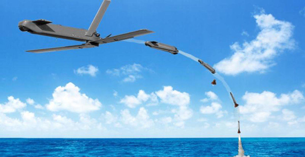
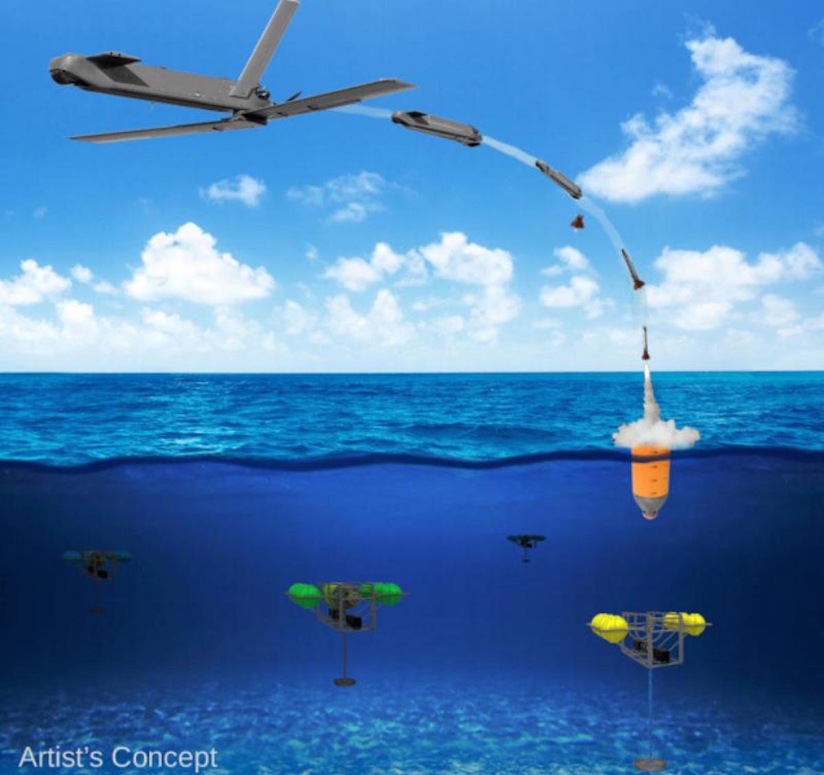
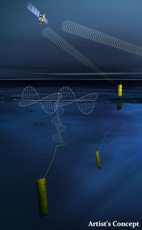
The Defense Advanced Research Projects Agency (DARPA) is researching a drone that can hibernate on the ocean floor for years at a time before being launched to the surface and into the air.
The “Upward Falling Payload” (UFP) concept centers on developing deployable, unmanned, nonlethal distributed systems that lie on the deep-ocean floor in special containers for years at a time. These deep-sea nodes could be remotely activated when needed and recalled to the surface. As DARPA terms it, they “fall upward.”
The new drones are part of a new focus by the U.S. military to develop and improve technology for emerging threats. “Today, cost and complexity limit the Navy to fewer weapons systems and platforms, causing strain on resources that must operate over vast maritime areas. Unmanned systems and sensors are commonly envisioned to fill coverage gaps and take action at a distance. However, power and logistics to deliver these systems over vast ocean areas limit their utility. The Upward Falling Payload (UFP) program intends to overcome these barriers,” DARPA said on its website.
DARPA’s statement continues: “Nearly 50 percent of the world’s oceans are deeper than 4 km, which provides vast areas for concealment and storage. As a consequence, the cost to retrieve UFP nodes is asymmetric with the likely cost to produce and distribute them to the seafloor. Concealment provided by the sea also provides the opportunity to quickly engage remote assets that may have been dormant and undetected for long periods of time, while its vastness allows simultaneous operation across great distances. Getting close to objects without warning, and instantiating distributed systems without delay, are key attributes of UFP capability.”
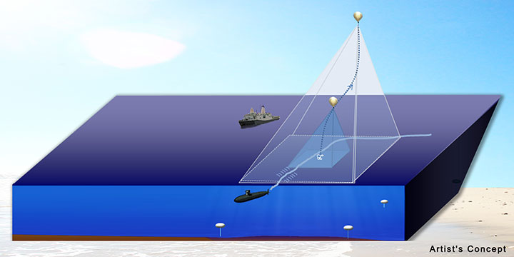
The UFP system would have three key subsystems:
The payload, which executes waterborne or airborne applications after being deployed to the surface
The UFP riser, which provides pressure tolerant encapsulation and launch of the payload
The UFP communications, which trigger the UFP riser to launch.
The program would need to demonstrate a system that can:
survive for years under extreme pressure
be triggered reliably from standoff commands
rapidly rise through a water column and deploy its payload.
The drones wouldn’t require fuel, as they would be powered with energy generated by ocean currents. Ocean drones would be difficult to manufacture, however, because researchers would need to figure out how to activate the drone, how to help the drone breach the surface, and make sure the drone is protected in salt water for long periods.
This artist’s concept shows a potential communications application of an upward falling payload. (Credit: DARPA)
Phase 2. The program is completing its first phase and is about to enter its second. During Phase 1, DARPA supported more than 10 study and design efforts to figure out approaches for long-range communications, deep-ocean high-pressure containment, and payload launch. The study teams also addressed a variety of missions for the payloads.
“In this first phase, we really learned about how the pieces come together, and built a community of developers to think differently about unmanned distributed solutions for the maritime domain,” said Andy Coon, DARPA Program Manager for the effort. “The trick is to show how these systems offer lower-cost alternatives to traditional approaches, and that they scale well to large open-ocean areas.”
In the next Phase, DARPA intends to learn from the studies, and develop and demonstrate prototype systems. DARPA is seeking teams to develop UFP nodes that combine expertise in both deep-ocean engineering and advanced payload development.
“We’re also looking for the communications technologies for these nodes. As long as you can command the nodes remotely and quickly, and don’t have to send a ship out to launch it, you’re in good shape. Some Phase 1 approaches were more exotic than others, but we were pleased by the range of challenging options,” said Coon.
In today’s fiscally constrained environment, such a system of pre-positioned, deep-sea nodes could provide a full range of maritime mission sets that are more cost-effective than existing manned or long-range unmanned naval assets.
For Phase 2, DARPA is particularly looking for technology communities that can team to provide expertise and innovation for small sensors, expendable and small unmanned systems, distributed communications and navigation technology, novel long-range underwater communications, and long-endurance mechanical and electrical systems that can survive for years in dormant states.
The “summary grant” process the Federal Aviation Administration (FAA) used last week to issue 30 Section 333 unmanned aircraft systems (UAS) exemptions is an example of how the agency is using a flexible regulatory approach to accommodate this rapidly evolving technology, according to a news statement from the FAA.
The new approach will speed up Section 333 exemption approvals for many commercial UAS operators, the FAA said. Section 333 is the part of the 2012 FAA reauthorization law that lets the Secretary of Transportation determine if certain low-risk UAS operations can be authorized before finalizing the small UAS proposed rule published in February.
Although the FAA still reviews each Section 333 petition individually, the agency can issue a summary grant when it finds it has already granted a previous exemption similar to the new request. Summary grants are far more efficient because the FAA doesn’t need to repeat the analysis performed for the original exemption on which they are based. Summary grants are a tool the FAA can use in all exemption areas, not just UAS.
The FAA’s experience in reviewing the Section 333 petitions shows they generally fall into two categories: film/television production and aerial data collection. Most exemptions in these categories will likely be handled through the summary grant process. For unique requests, the agency will still publish the petition in the Federal Register for public comment and will conduct a detailed analysis.
The FAA also made two other changes to the Section 333 exemption process last week:
The agency now allows operations under these exemptions by people who hold a recreational or sport pilot certificate. Previously, Section 333 operators were required to have at least a private pilot certificate. The newly added certificates are easier to obtain, and therefore less costly, than a private pilot certificate.
A third-class medical certificate is no longer required. Now, a Section 333 operator only needs a valid driver’s license to satisfy the medical requirement. This change is consistent with the agency’s approach for sport pilot certificate holders, who may fly light sport aircraft with a driver’s license and no FAA medical certificate.
Brian Wynne, president and CEO of the Association for Unmanned Vehicle Systems International (AUVSI), applauded the change. “For months, AUVSI has advocated for a more streamlined process for Section 333 exemptions that will help more industries realize the benefits of UAS technology,” Wynne said. ” The FAA’s new summary grant process is a step in the right direction that cuts through the red tape while making it easier for operators to fly UAS. We applaud the agency for lifting unnecessary restrictions and enabling more commercial uses of the technology in a safe and responsible manner.”
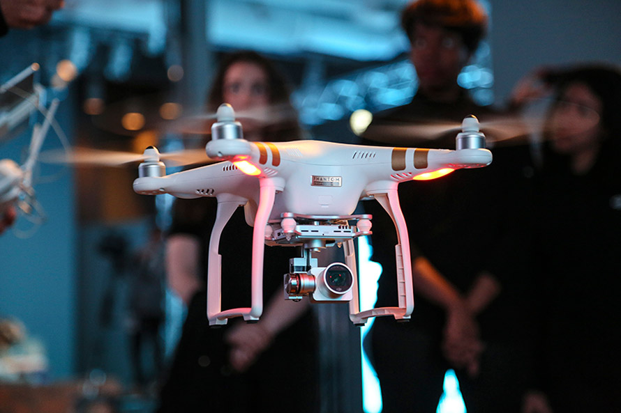
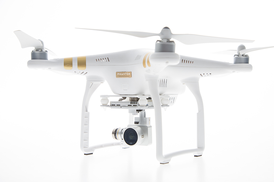
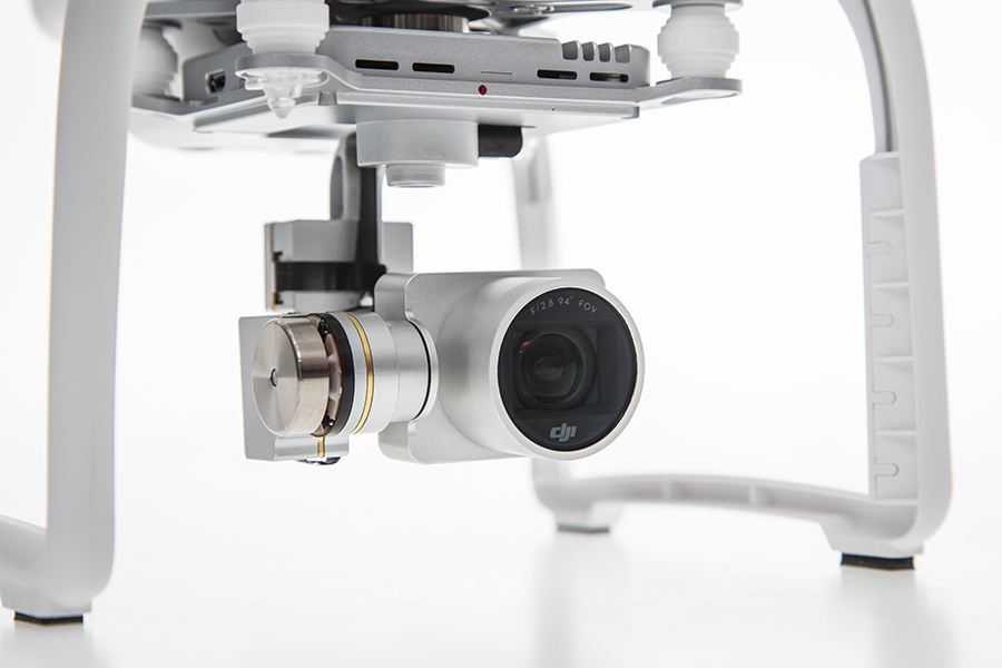
DJI has launched a new drone in its Phantom series. The Phantom 3 comes in two variations, Professional and Advanced, both of which provide greater control and creative options than the popular Phantom 2. On April 8, DJI held three simultaneous events in London, Munich, and New York to mark the release of the Phantom 3.
Both Phantom 3 versions feature the strongest professional control features DJI has developed so far. Using DJI’s Visual Positioning system, the Phantom 3 can hold its positioning indoors without GPS and can easily take off and land with the push of a button. With Vision Positioning technology, visual and ultrasonic sensors scan the ground beneath the Phantom 3 for patterns, enabling it to identify its position and move accurately.
DJI’s Lightbridge technology is also integrated, enabling control at up to 1.2 miles (2 km) away and a live HD video stream from the camera with almost no latency.
“In developing the next generation Phantom, DJI remained committed to providing a top-tier flight experience in one easy-to-use platform,” said DJI CEO Frank Wang. “We pride ourselves in creating a flying camera that fits in a backpack and can be ready to take professional quality videos from the sky in less than a minute.”
The Phantom 3 Professional is capable of shooting 4K video at up to 30 frames per second, while the Phantom 3 Advanced records at resolutions up to 1080p at 60 frames per second. These cameras are stabilized using 3-axis gimbals to keep the video smooth regardless of flight or wind conditions.
Both models shoot 12-megapixel photos using a 94-degree FOV, distortion-free lens, and a high-quality, 1/2.3-inch sensor that is more sensitive to light than the sensor in previous Phantom 2 Vision models.
All camera settings — including ISO, shutter speed and exposure compensation — can be set using both the DJI Pilot app and the physical controls on the remote controllers. The DJI Pilot app also features a Phantom 3 flight simulator for virtually practicing aerial maneuvers, and a Director feature, which automatically edits the best shots from flights into short videos that can be shared immediately after landing. The upgraded app also allows pilots to livestream their flights to YouTube.
“Pilots, whether they are journalists, extreme athletes, or global travelers — will not just be able to share aerial videos of where they were, but will also be able to send a YouTube link to their friends and colleagues to show them the aerial perspectives of where they are right now,” said DJI’s San Francisco General Manager Eric Cheng. “This has tremendous potential for changing the way we share experiences with one another.”
Jim Williams, manager for the Federal Aviation Administration’s Unmanned Aircraft Systems (UAS) office, will be the keynote speaker at the MAPPS National Surveying, Mapping and Geospatial Conference, scheduled for April 13-16 in Crystal City (Arlington),Va.
Williams will speak at a luncheon on April 14. He’ll address the recently published notice of proposed rulemaking issued by his office in FAA, including regulations and policies that will affect surveying and mapping firms that want to fly unmanned aerial vehicles (UAV) and UAS in the commercial market.
“MAPPS has worked with Mr. Williams and his staff for several years to assure that business and societal benefits of using UAV/UAS for aerial surveying, mapping and imagery are recognized and empowered in FAA policy,” said John Palatiello, MAPPS executive director. “UAV/UAS technology is the future of the mapping, surveying and geospatial profession. It is imperative that geospatial firms have the ability to operate UAV/UAS. Mr. Williams understands this, and his office’s policies have reflected his understanding of our community as an important stakeholder.”
“We’re honored to have Mr. Williams join us at the conference. We look forward to hearing how he sees the future of UAV/UAS and how it will effect the business and professional practice of surveying and mapping,” said Curtis Sumner, National Society of Professional Surveyors (NSPS) executive director. “His addition to the conference strengthens an already outstanding program.”
Full registration for the conference is required for admission to the keynote luncheon.
The unmanned drone RQ-4 Global Hawk in flight in 2007 (Image credit: U.S. Air Force photo by Bobbi Zapka)
By Art Kalinski, GISP
For more than a decade, the military has been struggling with cataloging and retrieving its huge libraries of full motion video (FMV). The video, captured by both manned and unmanned aircraft, rapidly reached unmanageable levels. If you have ever tried to organize vacation photos after returning home from a long trip, you know that it’s easy to lose track of where each photo was taken. Date/time stamps help, but the effort is still difficult if your vacation took you to numerous locations.
The manned U.S. Air Force Beech King Air 350 and 350ER MC-12W Project Liberty Aircraft are designed for intelligence, surveillance and reconnaissance (ISR).
Now imagine trying to retrieve several critical minutes out of thousands of hours of video of barren land or repetitive-looking villages, and you get a sense of the magnitude of the problem. Without some way to catalog the video, critical details can be lost, because finding the right video clip becomes impossible in a reasonable period of time. Everyone agreed that the solution to the problem is to index the video clips by date/time and location, preferably with an exact georeferenced footprint. This is now possible with tools from Esri, Hexagon Geospatial and others.
Several years ago, at the USGIF GEOINT Tech Days, Sarnoff (SRI) demonstrated a system that pinned aerial video to its geographic footprint and maintained that registration despite the movement of the aircraft. It was an achievement that impressed everyone in the audience. I changed jobs soon after that conference and lost track of developments in the FMV field. At the February Esri Federal Users Conference, I was thrilled to see Jack Dangermond briefly demonstrate the same kind of FMV georeferencing capability in ArcGIS 10.2 during his opening plenary session. I learned that Esri developed the capability in 2013, and later learned that Intergraph (Hexagon Geospatial) also developed a similar capability in 2010.
MISB: The Critical Improvement
The key technical development that made this possible was NGA’s creation of “Motion Imagery Standards” and the Motion Imagery Standards Board (MISB). The MISB developed standards for a consistent way to capture and record telemetry data during the video capture as metadata that becomes part of the video stream. This “Open Standard” metadata includes information such as the accurate xyz location of the aircraft, attitude, tilt, camera angle, and camera characteristics. This information travels with the individual video frames and permits the GIS/viewing software to perform the georeferencing.
This process is very similar to the oblique imagery capture system used for years by Pictometry, which at 20 FPS was technically FMV. MISB like Pictometry requires accurate GPS and IMU data to continuously capture and record the metadata. The MISB also gets involved with video compression standards such as the newer H.264 used on Blu-Ray discs and streaming video. H.264 has, for the most part, replaced MPEG2 and older MPEG4 as the video compression standard of choice. Much of the video captured by low-end small UAVs is just a simple video stream with no MISB telemetry data. However, I’m sure that lower prices, increased capability and smaller size of sensors will fix that with time. Sorry, no one has yet figured a way to “hack in” the metadata for legacy video captured without the MISB telemetry data. The one exception is those videos that contain usable telemetry data that was burned into the video and can be read with OCR. It might be possible to insert that information as MISB-compliant data.
The ArcGIS Full Motion Video Add-In
The ArcGIS Full Motion Video 1.2 Add-In (for ArcGIS 10.1, 10.2 and 10.3) is a free tool for ArcGIS users. It permits users to play georeferenced live or previously recorded video files in the map view. The screen capture below shows several features of this tool and is from an online video.
The re-sizeable smaller window displays the video as it runs. The map view shows a changing footprint (green trapezoid) of the video as the aircraft flies over the site. The short green line shows the flight path of the aircraft. Demonstrating the interconnectivity of the two data sets, the user in the demo video drew a light blue polygon on the map view. Note that the Esri Intersect function re-projects and displays the same polygon correctly in the video view.
Frames from the video can be extracted as single georeferenced images or groups of images and stored as a mosaic dataset. Playback of time-stamped video data can be synchronized with other time-enabled data and played together on the map. Features can be digitized directly on the video player and will appear on the map and vice versa.
The extension supports playback and management of multiple simultaneous video feeds. The Add-In also allows you to record the sensor, frame center, and footprint data in a geodatabase so the Bookmark Manager can perform searches for bookmarked video scenes. For more information regarding the Esri FMV tool, visit this ArcGiS site.
Hexagon Geospatial GeoMedia Motion Video Analyst Professional
Another robust FMV system that takes advantage of MISB telemetry is GeoMedia Motion Video Analyst Professional (MVA) from Hexagon Geospatial. The Hexagon Geospatial system includes tools to catalog videos as geospatial features with attributes extracted from the metadata, and has some elegant graphic selection tools that help an operator search and retrieve needed video clips.
In the screen capture below, you can see the map view with the geo-registered color video overlaid on the black-and-white ortho base image. As the video plays, the georeferenced video footprint continuously moves to the correct location as the tracking graphics in red show the position of the aircraft. The transparency of the video can be adjusted so an operator can compare features between the base image and the video and digitize directly in the map window.
MVA also includes a full set of tools for placing clipmarks as geospatial features with attributes and linked to the cataloged video, extracting snapshots and videos clips, on-the-fly enhancements, stabilization, registration and more. The system also facilitates rapid report generation so as an operator searches and plays appropriate video clips, the same operator or a partner can rapidly generate reports as documents or PowerPoint presentations in minutes. Another feature of the system is a “de-hazing” tool that removes a surprising amount of haze or smoke.
See a very good video overview of GeoMedia Motion Video Analyst Professional on this Hexagon Geospatial page. Like the Esri video, both are far better at explaining the capabilities than I can in this short column.
Other defense contractors are taking advantage of the MISB metadata, so check with your provider. Although these systems found their first home with military analysts, the Esri and Hexagon Geospatial reps indicated that many other users are finding the capability valuable in their work. Emergency operations centers come to mind first, but more mundane uses include rail and utility property management, the news media and video used in court proceedings. So, if you shoot lots of aerial video and need to catalog and retrieve video clips quickly, consider using MISB in your capture process.
Global Aerospace has made available a standard operating procedure (SOP) manual for small unmanned aircraft system (UAS) operations through its partnership with the Unmanned Safety Institute (USI). Global Aerospace will be exhibiting at booth 745 at the AUVSI’s Unmanned Systems 2015, held May 4-7 in Atlanta.
The “Visual Line of Sight SOP” outlines general operating procedures for UAS and will be made available to qualified Global Aerospace customers. USI is a subsidiary company of Global’s SM4 program partner, Waypoint Global Strategies.
Through the SM4 program, Waypoint and USI provide Global’s UAS customers with discounted consulting and data analytics services and access to flight training.
“Standard procedures are the foundation of safe operations,” said Alex Mirot, president of USI. “We are excited about offering this SOP manual to Global Aerospace customers as a way to promote safety and reduce errors.”
USI offers its clients customized workshops, assistance in drafting and adopting policy and procedures, risk assessment and management, safety assurance, and safety promotion.
Chris Proudlove, senior vice president and team leader, complex risks at Global Aerospace said, “Global Aerospace continues to develop products and tools for the rapidly growing sector of UAS. This comprehensive manual will provide an excellent resource for operators of small UAS.”
The Federal Aviation Administration has established an interim policy to speed up airspace authorizations for certain commercial unmanned aircraft operators who obtain Section 333 exemptions. The new policy helps bridge the gap between the past process, which evaluated every UAS operation individually, and future operations after the FAA publishes a final version of the proposed small UAS rule.
Under the new policy, the FAA will grant a Certificate of Waiver or Authorization (COA) for flights at or below 200 feet to any UAS operator with a Section 333 exemption for aircraft that weigh less than 55 pounds, operate during daytime Visual Flight Rules (VFR) conditions, operate within visual line of sight (VLOS) of the pilots, and stay certain distances away from airports or heliports:
5 nautical miles (NM) from an airport having an operational control tower; or
3 NM from an airport with a published instrument flight procedure, but not an operational tower; or
2 NM from an airport without a published instrument flight procedure or an operational tower; or
2 NM from a heliport with a published instrument flight procedure
The blanket 200-foot COA allows flights anywhere in the country except restricted airspace and other areas, such as major cities, where the FAA prohibits UAS operations. Previously, an operator had to apply for and receive a COA for a particular block of airspace, a process that can take 60 days. The agency expects the new policy will allow companies and individuals who want to use UAS within these limitations to start flying much more quickly than before.
Section 333 exemption holders will automatically receive a blanket 200-foot COA. For new exemption holders, the FAA will issue a COA at the time the exemption is approved. Anyone who wants to fly outside the blanket parameters must obtain a separate COA specific to the airspace required for that operation.
More information on the UAS exemption process is available on the FAA’s UAS page.
The Federal Aviation Administration has issued an experimental airworthiness certificate to an Amazon Logistics, Inc. unmanned aircraft (UAS) design that Amazon will use for research and development and crew training. Amazon has said it wants to use drones for delivering packages to customers.
The FAA typically issues experimental certificates to manufacturers and technology developers to operate a UAS that does not have a type certificate.
Under the provisions of the certificate, all flight operations must be conducted at 400 feet or below during daylight hours in visual meteorological conditions. The UAS must always remain within visual line-of-sight of the pilot and observer. The pilot actually flying the aircraft must have at least a private pilot’s certificate and current medical certification.
The certificate also requires Amazon to provide monthly data to the FAA. The company must report the number of flights conducted, pilot duty time per flight, unusual hardware or software malfunctions, any deviations from air traffic controllers’ instructions, and any unintended loss of communication links. The FAA includes these reporting requirements in all UAS experimental airworthiness certificates.
The public has until April 24 to comment on a framework of regulations proposed by the Federal Aviation Administration (FAA) in February. The regulations would allow routine use of certain small unmanned aircraft systems (UAS) in today’s aviation system, while maintaining flexibility to accommodate future technological innovations, the agency said.
The FAA proposal offers safety rules for small UAS (under 55 pounds) conducting non-recreational operations. The rule would limit flights to daylight and visual-line-of-sight operations. It also addresses height restrictions, operator certification, optional use of a visual observer, aircraft registration and marking, and operational limits.
The new rules would not apply to model aircraft. However, model aircraft operators must continue to satisfy all of the criteria specified in Sec. 336 of Public Law 112-95, including the stipulation that they be operated only for hobby or recreational purposes.
The public will be able to comment on the Small UAS Notice of Proposed Rulemaking for 60 days from the date of publication in the Federal Register. The proposed regulation was published for public comment on February 23, and comments will be accepted through April 24.