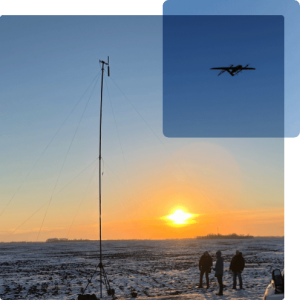
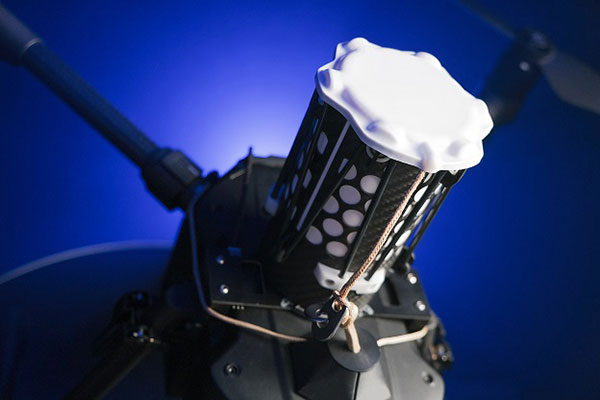
In December 2022, uAvionixannounced its updated product line for unmanned aerial systems (UAS) beyond visual line of sight (BVLOS) command and control (C2). The SkyLine C2 management platform and muLTElink airborne radio systems (ARS) are designed to integrate, which enables a self-healing C2 network capable of both path and link diversity. This eliminates lost-link possibilities over broad terrain and altitude ranges.
Image: uAvionixImage: uAvionix
MuLTElink ARS consists of two models — muLTElink915 and muLTElink5060, the core of the uAvionix C2 system. The muLTElink915 model combines globally licensed aviation LTE, enhanced with frequency hopping 902–928 MHz industrial, scientific and medical frequencies capability. The muLTElink5060 model combines global LTE with aviation-protected 5,030–5,091 MHz C-band for customers holding C-band licenses for control and non-payload communication (CNPC) operations.
Each muLTElink model allows up to one external CNPC radio to be optionally connected to allow simultaneous use of all three frequency ranges, higher power C-band operation or future radio integrations.
UAvionix updated its previous line of microLink and SkyLink ARS radios and relaunched them under the SkyLink ARS banner. Each SkyLink ARS can operate as a point-to-point radio or integrate with muLTElink and SkyLine for managed C2 operations. SkyLink915micro, formerly named microLink, offers a robust form factor and Lemo connector for UAS requiring hardened installations.
SkyLink5060micro and SkyLink5060 offer 100 mW and 10 W 5,030–5,091 MHz aviation protected C-band CNPC options.
Both platforms meet standards set by RTCA DO-362A and the U.S. Federal Aviation Administration’s draft Technical Standard Orders-C213a and may receive similar validated orders through other global aviation regulators.
Radio altimeters are critical in aircraft landing systems. (Getty image). (Photo: guvendemir/E+/Getty Images)
As most GNSS industry insiders already know, the Federal Communications Commission (FCC) has licensed adjacent GNSS L1 protection frequencies to Ligado Networks (formerly Lightsquared) for its nationwide 4G-LTE network.
Many objections emerged as expected this second time around from government agencies, industries and U.S. forces — yet the roll-out is still underway, pending actual interference occurring. This all in an attempt to find communications bandwidth for many emerging commercial radio applications.
Now, as 5G C-Band 3.7–3.98 GHz wireless phone networks begin their FCC approved roll-out, the Federal Aviation Administration (FAA) has apparently lodged an unanticipated objection on the grounds that cross-interference could compromise aircraft radar altimeter and wireless communications that operate at 4.2 to 4.4 GHz in the C-band.
While 5G wireless has already been operating in many parts of the world without reports of interference with aircraft systems, the FAA appears to be taking a more conservative approach to how aviation in the United States should co-exist with the new 5G phone wireless system. The FAA has proposed imposing an exclusion zone around airports for 5G wireless networks — which apparently have already been operating with reduced power in these areas — until cooperative operation has been proven.
Now along comes a new C-band wireless network (SkyLink) aimed at providing high-integrity unmanned aircraft systems (UAS) command and control (C2). The SkyLink company uAvionix has also developed a C-band Control & Non-Payload Communications (CNPC) radio for UAS applications.
Together with Thales, uAvionics recently tested its radio with its SkyLink radio network. The network has been qualified in accordance with the RTCA DO-377 standard for a network management system that monitors network and radio link health, and the radio has been developed to the draft FAA Technical Standard Order (TSO) C-213A to support critical UAS operations.
The network uses new DO-362A-compliant SkyLink C-band radios, integrates certifiable aviation-grade hardware and software, uses frequency agility, and provides critical fault monitoring and control capability. The objective is to obviate the loss of the C2 link with the vehicle, and thereby enable beyond-visual-line-of-sight (BVLOS) operations without an FAA waiver.
It’s unclear whether the emergence of the C-band network — approved by both the FAA and FCC — will play a role in the current phone network interoperability issue. However, uAvionix reports that several sites in the United States and offshore are either rolling out C-band SkyLink networks or evaluating doing so.
North Dakota already has an ISM-band SkyLink network at its UAS test site that will shortly transition to C-band.
The Choctaw Nation in Oklahoma under an FAA program seeks to enable BVLOS operations through a C-band C2 network.
New Mexico State University will use a Skylink C2 network around Las Cruces airport for small UAS (sUAS) operations and testing to overcome anticipated interference from nearby Air Force and Space Force operations.
The Tillamook UAS test range in Oregon has already installed the first ground site of a SkyLink network.
The University of Alaska at the Fairbanks UAS test site will use uAvionics radios for testing large, heavy UAS operations.
In Canada near the Jonesburg airport, a Skylink C2 network will support the safety case for BVLOS pipeline inspection operations for the oil industry.
While many of these new networks are not yet fully online, the use of frequency hopping, safety-monitored C-band, and certifiable transmissions for UAS command and control appears to be moving forward rapidly. Because the FAA is supporting this testing phase, it seems inevitable that large-scale C-band network rollout for UAS C2 will happen eventually.
5G phone networks, wireless UAS command and control, and aircraft safety systems essential for landing will need to find a way to co-exist and provide reliable, sustained service to their respective customer bases. Look for much more to develop in this ongoing tussle between industry groups and agencies who appear to have little in common, other than grudgingly sharing a crowded radio spectrum.
A roundup of recent products in the GNSS and inertial positioning industry from the August 2021 issue of GPS World magazine.
OEM
GNSS board
Photo: Javad GNSS
With GLONASS dynamic calibration
The TRE-3S GNSS board measures 100 x 80 mm, weighs 87 g and tracks 874 channels with all-in-view satellite tracking. It includes numerous features to protect against interference and improve signal output: spectrum data output, spoofing detection, advanced multipath reduction, in-band interference rejection, GLONASS 0.2-mm dynamic calibration, heading determination, attitude determination and fast acquisition channels. The TRE-3S receives GPS L1/L2/L2C/L5; Galileo E1/E5A/E5B/AltBoc/E6; GLONASS L1/L2/L3; BeiDou B1/B1C/B2/B3; QZSS L1/L2/L5/L6 (L61/L62); and SBAS L1/L5. It has a 20-Hz update and real-time kinematic (RTK) rate for real-time positioning and raw data (code and carrier). Optional features include tracking QZSS L6 (LEX) and IRNSS L5/S-band, and a data update rate and RTK rate of 100 Hz.
For high-precision applications with L-band corrections
Photo: Maxtena
The M9HCT-A-SMA is a patented helix antenna for GNSS plus L-band corrections services, suitable for high-precision and autonomous multi-frequency applications. It provides simultaneous GNSS reception in a rugged, compact form factor. The M9HCT-A-SMA is suitable for high-precision applications such as the UAV market, where high performance and low weight are driving features in antenna selection. The active helix design features Maxtena’s patented compact and lightweight Helicore technology, which provides excellent pattern control, polarization purity and high efficiency in a compact form factor.
New eXtended Filtering (XF) is now employed in the TW3900 series of Accuntena precision antennas. The XF feature mitigates interference from all near-band signals and ensures the antenna provides the purest possible GNSS signals. The custom XF filtering has been tested to mitigate new (in Europe and Japan) and existing LTE signals, enabling the XF antennas to produce clean and pure GNSS radio frequency data. The XF models are TW3972XF, TW3972EXF, TW3972LGXF, TW3967XF and TW3967LGXF. All are triple-band antennas that support GPS/QZSS (L1/L2/L5), GLONASS (G1/G2/G3), Galileo (E1/E5ab), BeiDou (B1/B2/B2a), NavIC L5 and L-band correction services.
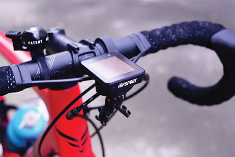
The iGS320 cycling computer builds on the u-blox M10 positioning platform, leveraging the M10’s ultra-low power consumption, compact size, and ability to track all four GNSS to offer endurance athletes a superior user experience. Adopting the M10 in its iGS320 cycling computer brought iGPSPORT an 80 percent increase in the power autonomy to deliver 72 hours of continuous tracking, up from 40 hours in their previous device. Concurrent reception of up to four GNSS constellations increases coverage and accuracy in otherwise challenging signal environments.
The Beamo 3D mapping platform enables surveyors to scan a project site and immediately collaborate with teams in the field without lengthy delays or cumbersome equipment. The digital twin created in the platform provides a single and secure source of truth for teams without requiring highly technical knowledge. With a 360-degree camera, surveyor teams can create detailed digital environments that remote teams can use to track progress, collaborate with coworkers, and take accurate measurements without having to physically visit the site.
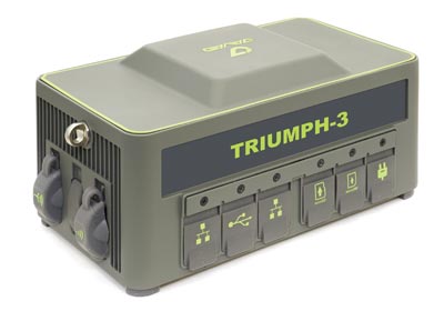
The Triumph-3 receiver tracks efficiently even in difficult conditions. It can track all current signals and is ready for future satellites. The Triumph-3 can operate as a base together with Triumph-LS and Triumph-LS Plus to efficiently accomplish any geodetic job. Its RTK system communicates via integrated UHF, 4G/LTE, Wi-Fi and Bluetooth channels, and eliminates the need to subscribe to a real-time network for corrections. A powerful and reliable receiver for high-precision navigation systems, the Triumph-3 is based on the Javad GNSS 874-channel chip. It is equipped with an internal 4G/LTE/3G card and secure and accessible microSD and microSIM cards. It also supports Javad’s lift-and-tilt technology.
Eos Bridge enables almost any instrument to become iOS Bluetooth compatible. The pocket-sized device connects to instruments via Bluetooth Classic or serial port, and then transmits data to any Apple iOS device, such as iPhone or iPad, Android device or Windows mobile device. Instruments equipped with non-iOS Bluetooth can connect to Apple iOS devices using the Eos Bridge, including laser rangefinders and utility-locating instruments. Instruments whose only connectivity option is a serial port also can connect, such as any instrument or sensor with an RS-232 serial port. The Eos Bridge is lightweight, at approximately 150 grams (about 5.3 ounces). It can be worn clipped to a belt, stored in a pocket, or mounted to an instrument or sensor. The battery lasts 48 to 72 hours.
The OceanReports web tool provides users with specialized “ocean neighborhood analyses,” including maps and graphics, by analyzing more than 100 ocean datasets instantaneously. Reporting data includes information about habitats and species, industries in the area, potential hazards (such as undersea cables or shipwrecks), the economic value of ocean commerce, and other detailed oceanographic information. The web-based interactive tool for ocean mapping and planning, created by the National Oceanic and Atmospheric Administration (NOAA) and the Department of the Interior’s Bureau of Ocean Energy Management, provides professional users and the general public with opportunities to explore the ocean from their own computer.
HxGN Mass Transit is a geospatial transportation infrastructure management system with 3D and AI capabilities for visualizing and analyzing transit and rail assets and operations. Built on Hexagon’s M.App Enterprise, HxGN Mass Transit provides an advanced digital twin of a city’s entire public transportation network — including tracks, stops, switches, construction sites, ticket machines, benches and garbage cans. It integrates asset and spatial data so operators can visualize and analyze an entire network with accurate and up-to-date information.
The GAJT-410MS provides anti-jamming to marine vessels. (Image: NovAtel)
The GAJT-410MS provides NovAtel’s GPS Anti-Jam Technology (GAJT) for the commercial and defense marine markets. The low SWaP variant protects civil and military operations from interference and jamming, with jammer direction-finding capabilities for enhanced situational awareness in the marine environment. The GAJT-410MS provides dynamic protection on both GPS L1 and L2 bands, as well as Galileo E1, QZSS L1 and L2, and SBAS L1 to combat intentional and unintentional interference.
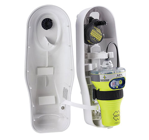
The ACR 2830 GlobalFix V4 EPIRB marine distress beacon has multiple built-in redundancies to increase chances of survival in an emergency situation. The internal GPS receiver pinpoints the user’s location, which is then transmitted on the 406-MHz distress signal. In the absence of GPS-derived coordinates, the signal can be used to triangulate the position. The beacon’s 121.5 MHz homing signal will bring local search-and-rescue forces directly to the position; an LED strobe light allows them to see the position in low light. A Category 1 Emergency Position Indicating Radio Beacon (EPIRB), the GlobalFix V4 is a float-free device that will automatically activate when submerged in water. Two self-tests monitor transmission, power and battery performance as well as GPS acquisition.
A new connected platform for rail passengers with Wi-Fi, information and entertainment content is being installed on OUIGO Spain trains through the OUIFUN portal. Passengers can connect via smartphones, tablets or PCs, access the internet on board to check email or browse the web, and enjoy entertainment content. Passengers also will be able to get travel status information in real time via an interactive map, access tourist guides or consult a menu for on-board catering. The service, provided by Moment, launched on May 10 on OUIGO’s first high-speed line in Spain connecting Madrid to Barcelona, and will gradually be extended to the whole high-speed OUIGO network.
The ANAFI Ai UAV uses 4G as its main data link between the drone and the operator. The 4G link improves data transmission and enables precise control at any distance. For BVLOS flights, it stays connected even behind obstacles. The 4G link between the drone and the user’s phone is encrypted, with a secure element protecting both software integrity and data privacy. A software development kit enables creation of custom code for flights and gives access to all sensors, including obstacle-avoidance sensors, occupancy grid and internet access.
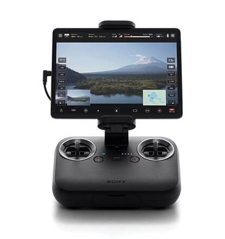
An introductory model in Sony’s new Airpeak line, the small S1 drone can be equipped with the company’s full-size mirrorless interchangeable-lens Alpha camera. Its proprietary motor, propeller, control system and sensing technology allow it to fly at high speed (a maximum speed of 55 mph) with stable wind resistance. Propulsion technology using a combination of devices developed by Sony provides wind resistance in strong wind speeds up to 44.7 mph. The Airpeak S1 includes obstacle detection, automatic flight control via sensing, and increased safety via cloud management of the aircraft.
At 80 grams, George is a low SWaP certifiable solution for enterprise operations and those wishing to type certify their UAS. Built around the open-source autopilot Cube from CubePilot, George combines Cube with Design Assurance Level C (DAL-C) hardware and safety and sensor monitoring, enabling customers to meet the type certification and safety case requirements for BVLOS operations. Its triple-redundant IMU includes three accelerometers, three gyroscopes, three magnetometers and three barometers. The hardware platform is designed and built to RTCA DO-254 DAL-C and meets rigorous DO-160G and MIL-810H power and environmental qualifications.
uAvionix Corp. has received a Technical Standard Order (TSO) from the U.S. Federal Aviation Administration (FAA) for its truFYX GPS receiver for unmanned aircraft systems (UAS).
Capable of receiving satellite-based augmentation system (SBAS) and wide area augmentation system signals, the receiver specifically targets UAS platform navigation and surveillance solutions.
With an increased regulatory focus on certifiability of UAS for beyond visual line of sight (BVLOS) operations, truFYX provides a critical component to enable safe navigation and airspace integration. A uAvionix’s blog article — “Why Certified GPS with Integrity for UAS Navigation Matters” — describes the importance of GPS receivers for UAS BVLOS operations.
The TSO-C145e Class Beta 1 GPS weighs 20 grams, which includes the receiver, antenna, DO-160G power supply and interface protection circuits. A Class Beta 1 GPS enables the truFYX to be the primary position source for domestic enroute and terminal navigation, as well as the primary position source for ADS-B OUT solutions.
The Source Integrity Level 3, System Design Assurance 2 system ensures reception and processing by Air Traffic Control and Traffic Collision Avoidance System when used as a position source for ADS-B. For these reasons, the Airbus Zephyr program was announced as a truFYX launch customer in January.
A certified position source for UAS navigation reduces position error by implementing a strict Receiver Autonomous Integrity Monitoring (RAIM) / Fault Detection and Exclusion (FDE) engine, and processing advanced SBAS messages designed to improve accuracy and integrity. These systems combine to detect unhealthy GPS satellite transmissions and remove them from the position calculation, providing critical differentiation from a typical commercial GPS receiver.
Design Assurance Level C software and hardware is achieved through the use of RTCA DO-178C and DO-254 engineering processes. As with all uAvionix TSO certified avionics, truFYX is manufactured in Montana under an FAA Manufacturing Inspection District Office approved quality-control process and facility.
truFYX technology has been previously TSO-certified in several form factors, including the highly integrated and complex skyBeacon, tailBeacon and tailBeaconX platforms.
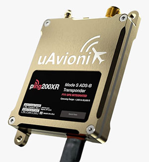
uAvionix has added a new low-SWaP transponder to its line-up of unmanned aerial system (UAS) communications, navigation and surveillance solutions.
The ping200XR integrates the capability of the ping200X TSO Certified Mode S ADS-B OUT transponder with the high-integrity truFYX TSO-certified GPS position source into a single enclosure. The single enclosure simplifies installation and allows the customer to choose between the existing installed GPS antenna or one provided with the ping200XR.
The integrated GPS ensures maximum safety by providing Source Integrity Level (SIL) 3 RTCA DO-229D and TSO-C145e Class Beta 1 performance, a requirement for Mode S and ADS-B airspace access, and for reception and processing by certified avionics and Traffic Collision Avoidance Systems (TCAS) in other aircraft, as well as Air Traffic Control (ATC). SIL 3 performance is not available from non-aviation certified GPS, which are often used as an autopilot navigation source.
The ping200XR can be integrated with popular onboard UAS autopilots for dynamic control from ground-control stations, including George — uAvionix’s enterprise autopilot solution. The ping200XR can also be pre-configured before flight and carried as a payload.
Replicating the functionality of a cockpit transponder controller, the uAvionix mini-controller allows users to dial-in a squawk code before takeoff for even quicker integration and rapid deployment.
uAvionix Corp has launched its first autopilot for unmanned aircraft systems (UAS), named George.
At 80 grams, George is a low size, weight and power (SWaP) certifiable solution for enterprise operations and those wishing to type certify their UAS. It is manufactured in the United States.
Built around the open-source autopilot Cube from CubePilot, George combines Cube with Design Assurance Level C (DAL-C) hardware and safety and sensor monitoring, enabling customers to meet the type certification and safety case requirements for beyond visual line of sight (BVLOS) operations.
George’s triple-redundant inertial measurement unit (IMU) system includes three accelerometers, three gyroscopes, three magnetometers and three barometers, one of which has been TSO-certified under TSO-C88b in other uAvionix products such as skyBeacon, tailBeacon and ping200X. The hardware platform is designed and built to RTCA DO-254 DAL-C and meets rigorous DO-160G and MIL-810H power and environmental qualifications.
George is plug-and-play compatible with all of uAvionix’s certified and uncertified products, including
truFYX GPS (TSO-C145e)
ping200X (TSO-C112e, TSO-C166b, TSO-C88b)
RT-2087/ZPX-B (AIMS MkIIB)
pingRX Pro dual-band ADS-B receiver for detect and avoid
the microLink or SkyLink C-band command and control solutions
“The flight control capabilities of the Cube are superb, backed by hundreds of thousands of man-hours of engineering and experimentation over the past 10 years,” said Paul Beard, CEO of uAvionix. “But what has been lacking is a hardware platform that matches that capability in robust performance. George brings everything we’ve learned about certified avionics to the autopilot space in a way that outperforms existing enterprise and military autopilots in a lower SWaP package.”
George will be available for beta test-launch customers in June with production units available in the third quarter.
uAvionix first revealed this concept in a 2018 white paper titled “ADS-B Inert and Alert – A Solution to the ADS-B Spectrum Concerns.” The Inert and Alert Concept preserves spectrum by allowing the onboard UAS ADS-B solution to remain inert in a non-broadcasting listening mode until a safety-critical event such as a C2 lost-link or other aircraft proximity triggers it to begin broadcasting its ADS-B position as an alert. Once the conditions are safe again, the system reverts to its inert state.
“uAvionix is a firm believer in the benefits of a cooperative airspace for UAS integration,” said Christian Ramsey, president of uAvionix. “Recognizing the concerns by regulators of over-use of the spectrum, Inert and Alert is a means to leverage ADS-B for collision avoidance while significantly reducing those concerns.”
A roundup of recent products in the GNSS and inertial positioning industry from the October 2020 issue of GPS World magazine.
OEM
GNSS antennas
Active and passive
Photo: 2J Antennas
A new range of high-precision GNSS antennas is designed for superior accuracy and reliability, with both active external antennas and passive internal ceramic antennas. The antennas provide precision, high bandwidth, and an advanced signal design for GPS, GLONASS, BeiDou, Galileo, IRNSS and SBAS navigation. They are designed for demanding GPS applications that require centimeter-level accuracy by combining precise point positioning (PPP) of L1 and L2 or by combining L1 and L5 bands with real-time kinematic (RTK) satellite navigation. Applications include aviation safety, UAVs, transportation, autonomous vehicles, agriculture and land and hydrographic surveys.
The HC976 housed and HC976E embedded helical antennas are light and compact, suitable for applications ranging from autonomous navigation to GNSS timing. Both models support GPS/QZSS-L1/L2/L6, GLONASS-G1/G2, Galileo-E1/E6, and BeiDou-B1/B3 frequency bands as well as regional augmentation systems and high-precision L-band correction services. The HC976 and HC976E support QZSS-L6, Galileo-E6 and BeiDou-B3. The HC976 is 44 x 62 millimeters and weighs 42 grams. It features a precision-tuned helical element that provides an excellent axial ratio and operates without the requirement of a ground plane, making it suitable for a wide variety of high-precision applications.
The mosaic-T GPS/GNSS receiver module is built for resilient and precise time and frequency synchronization under challenging conditions. Its multi-frequency, multi-constellation GNSS technology with AIM+ Advanced Interference Mitigation algorithms allows mosaic-T to achieve maximal availability even in the presence of GNSS jamming or spoofing. The compact surface-mount module is designed for automated assembly and high-volume production. Mosaic-T delivers timing and has additional inputs for an external high-accuracy clock.
The HGuide n380 inertial navigation system (INS) communicates an object’s position, orientation and velocity when GNSS signals are unavailable. It is built to withstand harsh environments in the air, on land or at sea. It is designed to meet the need for a small, high-performance INS for 3D mapping, surveying and other applications where space is at a premium. It is composed of Honeywell’s HGuide i300 inertial measurement unit (IMU), a GNSS receiver and Honeywell’s proprietary sensor-fusion software, which is based on the algorithms used for navigation on millions of aircraft every day.
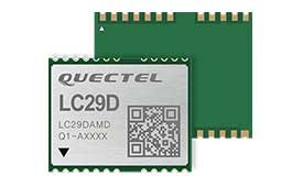
The LC29D eMobility module is a sub-meter-level GNSS module that integrates dead-reckoning and multi-band (L1/L5) real-time kinematic (RTK) algorithm technologies with fast convergence times and reliable performance. The module supports dual-band GNSS raw data output and integrates a 6-axis IMU sensor to deliver high-accuracy positioning performance in seconds. Based on the Broadcom BCM47758 GNSS chip, the LC29D can concurrently receive signals from up to six constellations (GPS, GLONASS, Galileo, IRNSS, BeiDou and QZSS), which maximizes the availability of sub-meter level accuracy. It offers a position update rate of up to 30 Hz (fusion output), enabling dynamic applications like shared emobility, delivery robots and precision agriculture to receive position information with lower latency.
The AlphaUni 300/900/1300 lidar series provides light, versatile long-range laser scanner systems for the high-end market. The series provides optimized data sets powered by advanced GNSS/inertial navigation system (INS) sensors and long-range Riegl scanners. AlphaUni’s design adapts to a variety of applications and can be installed on a variety of platforms, including multi-rotor UAV, fixed-wing vertical-takeoff-and-landing (VTOL) UAV, vehicles, rail trolleys, backpacks, boats and more.
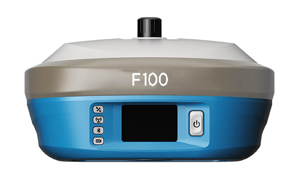
The F100 GNSS receiver, an upgrade to the F90, is designed to meet surveyors’ demands for high field performance, flexibility and cost-effectiveness. It tracks multiple constellations (GPS, GLONASS, Galileo, BeiDou) and can maximize the acquisition and tracking process with all-in-view GNSS frequencies. The 1.45-inch color LCD display is a multi-touch capacitive screen. The F100 has 32GB of internal memory. Its integrated second-generation web user interface control is compatible with all devices and browsers.
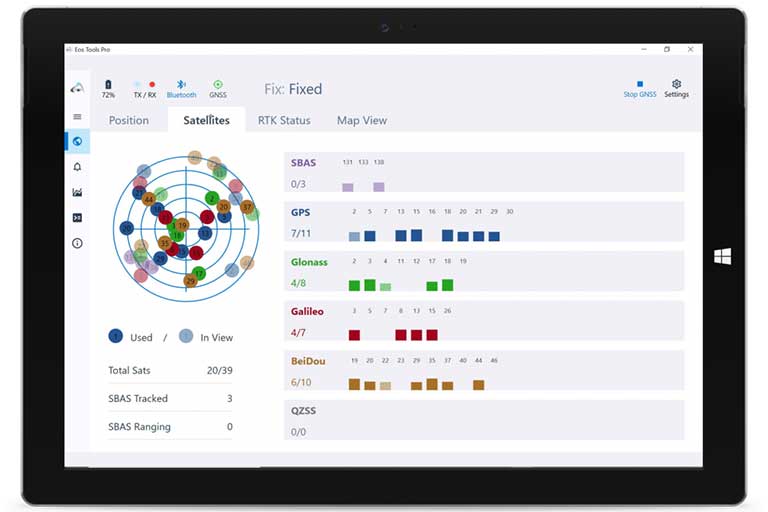
Eos Tools Pro for Windows 10 implements powerful new features that enable users to exploit all four global GNSS constellations and a state-of-the-art NTRIP client to access real-time kinematic (RTK) bases and RTK networks all over the world via NTRIP, Direct IP and wireless radios. It provides the latest support for Windows Geolocation and other features by Microsoft to allow customers to use high-accuracy locations directly in their apps, such as RTK network/RTK base connectivity, support for all new Beidou and Galileo satellites, and SafeRTK functionality for areas with marginal cellular coverage. Features for app developers are also available.
The BB4 UAV high-end multi-rotor drone is optimized for the AlphaUni 300/900/1300 lidar series. Its modular design simplifies deployment in just a few minutes. Its 7-kg payload breaks the capacity barrier, and its more than 45 minutes of flight time increases the airborne lidar survey ability. The redundant CHCNAV and DJI inertial measurement unit (IMU) and GNSS unit provide reliable centimeter real-time kinematic (RTK) positioning, meeting the demand for high accuracy in the geospatial and mapping industries.
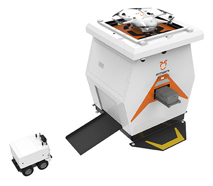
The ADNET autonomous delivery network is a technical solution to transport medical samples and quarantine materials in cities. It uses an RA3 drone, unmanned vehicle RG1 and RH1 hub station to deliver medical supplies without relying on manpower, alleviating time spent in traffic and the cost of traditional delivery. Supplies retrieved by the RG1 vehicle are delivered to the RH1 hub for sorting and redirecting, while the drone transfers the supplies between hubs. The RG1 then delivers goods on the receiving end. The system was demonstrated during China’s COVID-19 epidemic prevention and control period, reducing contact between samples and personnel.
The VECTOR-400 is a compact autopilot designed specifically for unmanned aerial vehicles. It features a robust enclosure and a military-grade connector for harsh environments (MIL-STD 810 and MIL-STD 461). Features enable sea-skimming (extremely low-level flight) and the capability to navigate without GNSS. The VECTOR-400 is able to continue a mission in case of individual sensor failure and when subject to jamming, maintaining accurate estimations of attitude and position. Advanced algorithms provide stall prevention and the ability to carry out an efficient gliding maneuver in case of engine failure. Its air data attitude and heading reference system and inertial navigation system provide high-precision attitude information and reliable navigation under demanding circumstances.
The F700 DroneHunter UAS is a radar-based autonomous interceptor drone for tracking and stopping dangerous drones. Its flexible undercarriage offers interchangeable counter measures for single, multiple or swarm-based threats, while its lightweight carbon-fiber frame enables quick speed and response. The F700 can carry multiple types of anti-drone countermeasures and deploy them in real time, based on which dynamic threat is detected miles beyond the protected area. The pogo pins and payload snaps of the undercarriage are integrated with artificial intelligence for firing and flight software.
Drones equipped with cost-intensive cameras and sensors need protection in the event of a flight-system failure. A parachute system for the DJI M210 drone is now available. Both commercial and emergency response operations are using the M210; its design and flexibility allow for a variety of industry-specific applications. The DRS-M210 parachute system is designed to ensure high pendulum and wind stability, allowing a damaged drone to land safely with minimal impact.
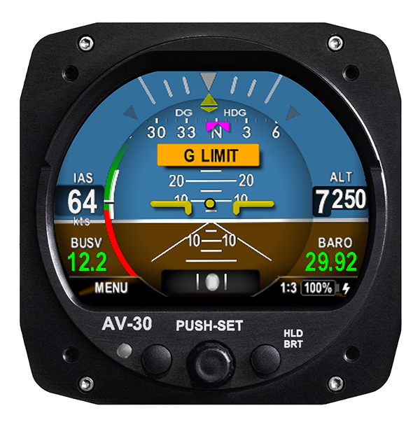
Altitude indicator (AI) or directional gyro (DG) replacement
Photo: uAvionix
The AV-30-C aircraft panel display adds a suite of in-flight information for pilots, including GPS navigational data, a probeless angle of attack indicator, baro-corrected altitude, indicated/vertical/true airspeed, non-slaved heading, bus voltage and G load. It is designed to fit into any aircraft with a 3 1/8-inch round instrument slot without cutting or modifying the panel. It is authorized for FAR Part 23 Class 1 and Class 2 aircraft listed on the AV-30-C Approved Model List (AML), containing 635 aircraft models including Cessna, Piper, Beechcraft, American Champion, Maule, Boeing, Swift, Mooney, Aviat and others.
The R3S series of rugged, EN-50155-certified fanless vehicle/rail computers is equipped with a u-blox NEO-M8N module, which receives GPS, Galileo, GLONASS and BeiDou with the default set for GPS + GLONASS dual band. The series offers power-efficient performance for consolidating in-vehicle workloads such as video surveillance, control/monitoring, passenger information and Wi-Fi hotspot sharing. For edge-to-cloud connectivity, R3S uses its internal GPS/GLONASS chipsets for GPS tracking and has two M.2 slots with up to 4x SIM card readers for failover LTE connection. To ensure proper operations in moving vehicles, the series is certified with EN50155, EN50121-3-2, EN50121-4, EN50125-3, EN45545 and E13 standards and has passed MIL-STD-810G shock and vibration resistance certifications. The series can operate under a wide temperature range and offers excellent reliability in harsh railway settings. It has one external removable 2.5-inch HDD/SSD drive bay for recorded footage storage. For consolidating in-vehicle workloads such as in-vehicle control/monitoring and passenger information, the R3S features a variety of I/O support, including 2x HDMI, DI/DO, 3x COM/CAN BUS and 4xUSB ports.
UAvionix Corporation’s aircraft AV-30-C panel display has received STC (Supplemental Type Certification) approval from the U.S. Federal Aviation Administration. The AV-30-C offers pilots an effective and affordable altitude indicator (AI) or directional gyro (DG) replacement with additional features.
AV-30-C is installable as either an AI or DG and adds a suite of in-flight information to the panel out of the box, including GPS navigational data, a probeless angle of attack indicator, baro-corrected altitude, indicated/vertical/true airspeed, non-slaved heading, bus voltage, G load and more with additional features to be announced.
AV-30-C is designed to fit into nearly any aircraft with a three and one-eighth inch round instrument slot without cutting or modifying the panel. By mounting from behind the panel, AV-30-C preserves the aircraft’s original classic look while bringing the latest that modern avionics has to offer to the panel.
The AV-30-C STC provides authorization to install in FAR Part 23 Class 1 and Class 2 aircraft (singles and twins weighing less than 6000 lbs) that are listed on the AV-30-C Approved Model List (AML), containing 635 Aircraft models including Cessna, Piper, Beechcraft, American Champion, Maule, Boeing, Swift, Mooney, Aviat and others. The full AML is available at uAvionix.com/AV-30.
AV-30-C works as a single primary instrument or by installing two units, one as an AI and another as a DG. The aircraft’s original failure-prone vacuum pump system can be removed to further benefit from a fully digital primary instrument cluster.
AV-30-C extends its functionality outside the cockpit as the companion to tailBeaconX, the latest 1090/ES ADS-B transponder with Aireon support for worldwide use and future mandated airspaces. Upon tailBeaconX TSO certification, AV-30-C can double as tailBeaconX’s control interface, allowing the pilot to set the mode and squawk easily, while maintaining AV-30’s existing feature set. tailBeaconX with AV-30-C removes the need to drill additional holes in the airframe to satisfy requirements in countries outside the U.S. and keeps installation costs to a minimum.
“uAvionix is creating avionics with fundamental engineering advantages,” said COO, Ryan Braun. “These are beautiful, no-compromise certified avionics designed to deliver an affordable total cost of ownership. The AV-30-C provides an innovative probeless angle-of-attack and non-slaved directional gyro, both designed to dramatically lower the cost of installation without compromising performance. Where other avionics seem designed to be replaced, the AV-30-C will get better with age. We’re actively developing ADS-B In, electronic flight bag, transponder, and autopilot integrations to ensure AV-30-C becomes an indispensable instrument for every panel.”
AV-30-C will support third-party autopilot systems via the APA-MINI adapter, interfacing AV-30’s heading bug with legacy autopilots. The APA-MINI autopilot adapter is expected to be released in early 2021, with more advanced autopilot integrations to follow.
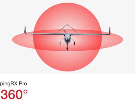
uAvionix has announced pingRX Pro, a detect-and-avoid ADS-B receiver for professional unmanned aircraft systems (UAS). PingRX Pro is expected to be available in the fourth quarter of this year.
pingRX Pro detects private and commercial aircraft operating on 978 MHz and 1090 MHz. The received aircraft’s identity, position and altitude are visualized on a moving map in real time, allowing the UAS operator or autopilot to remain well clear.
The new pingRX Pro continues uAvionix’s lineage of easy to integrate receivers with direct support for popular Ardupilot-based autopilot systems. By adding the protection of an aircraft-grade aluminum case and detachable remote mount antenna, pingRX Pro provides an ADS-B receiver for professional UAS operators who need performance, quality and flexibility for limitless UAS applications.
“UAvionix has led the way in ADS-B solutions for unmanned aircraft since our founding.” said Christian Ramsey, president of uAvionix. “Industry leaders and BVLOS operators continually choose ADS-B receivers as their primary detect-and-avoid solution. pingRX Pro now offers manufacturers and integrators the installation flexibility they need for their enterprise aircraft. ”
Weighing less than 8 grams, pingRX Pro features uAvionix ping ADS-B, proven in over a half-million ADS-B solutions worldwide, from UAS to airport vehicles to certified general aviation solutions.
PingRX Pro offers an external antenna, allowing operators to install it anywhere on the airframe. UAS are often designed from materials that can block radio frequencies and impair radio performance. By providing an external remote mounted antenna, performance can be maximized while providing critical protection of the receiver mounted inside the fuselage.
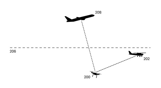
ADS-B Out
Diagram: uAvionix
ADS-B uses precision GPS information to broadcast the position of an aircraft in real time. The technology allows aircraft to share the skies more efficiently by telling each other where they are.
With ADS-B already widely adopted by manned aircraft, the task of detect and avoid is eased because the manned aircraft are broadcasting their position directly to the drone operator with no intermediary. While many aircraft not yet equipped with ADS-B OUT, nearly all large commercial operators are equipped.
The United States requires ADS-B OUT on all manned aircraft with an engine-driven electrical system operating near medium and large cities from the surface to 4,000 feet above ground.
Given the likelihood of ADS-B OUT on manned aircraft, and the density in these prime areas for inspection and package delivery, pingRX Pro ADS-B IN enables drone operators to meet their requirement to remain well clear of surrounding aircraft.
PingRX Pro tracks 100 simultaneous aircraft at ranges exceeding 150 miles, all at nearly 200% less power consumption of the alternatives.
A roundup of recent products in the GNSS and inertial positioning industry from the January 2020 issue of GPS World magazine.
OEM
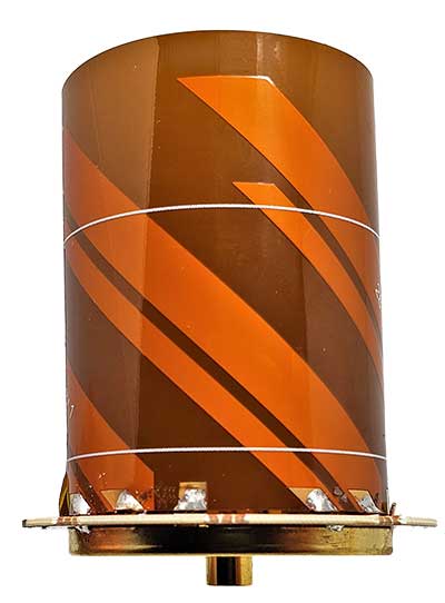
Heavy-duty antenna
For challenging environments
AT311 antenna. (Photo: CHC Navigation)
The heavy-duty CHCNAV AT311T is designed for demanding applications subject to shocks and vibrations. With advanced filtering and robust signal tracking, it provides survey-grade GNSS signals to enhance position reliability for marine applications, machine control, precision agriculture and industrial automation. Features include multi-constellation GNSS tracking using GPS, GLONASS, BeiDou, Galileo, QZSS, IRNSS and SBAS. Its IP68 water-resistant design makes it safe to use in extreme conditions with a wide temperature range (–40° C to +85° C). Its internal stacked structure enhances performance in high-interference environments, and the 40-dB signal gains, advanced signal filtering and multipath rejection design provide superior and robust GNSS signal tracking in challenging surroundings.
The UAS1 GNSS receiver module has been designed for UAV/UAS applications requiring centimeter accuracy in a small package.(Photo: Trimble)
The UAS1 compact, high-precision GNSS board was designed for unmanned aerial systems (UAS). It allows UAS system integrators to add upgradeable GNSS-based positioning using rugged connectors and Trimble’s software interface. Its 336-channel GNSS engine is capable of tracking L1/L2 frequencies from GPS, GLONASS, Galileo and BeiDou for centimeter-level, real-time kinematic (RTK) positioning. The compact board provides capabilities from high-accuracy GPS-only to full GNSS features. The receiver supports fault detection and exclusion (FDE) and receiver autonomous integrity monitoring (RAIM). System integrators also have the ability to detect interference with an RF spectrum monitoring and analysis tool embedded in the receiver.
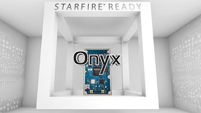
The Onyx multi-frequency GNSS OEM board offers integrated StarFire/real-time kinematic (RTK) GNSS capabilities. It features 255-channel tracking, including multi-constellation support for GPS, GLONASS, BeiDou and Galileo. It provides high performance in GNSS receiver sensitivity and signal tracking as well as patented multipath mitigation, interference rejection and anti-jamming capabilities. Through software options, the Onyx ,allows upgrades from free differential GPS signal sources such as WAAS, to increased accuracy services such as StarFire and RTK Extend. The software-enabled features are sold in bundles, but can also be purchased individually to suit changing application needs.
The OSA 5401 and OSA 5405 now enable power utility and broadcast networks to achieve sub-microsecond synchronization. (Photo: Business Wire)
The OSA 5401 and OSA 5405 upgraded PTP grandmaster clocks deliver precise, robust timing in a compact form factor. Oscilloquartz PTP timing technology enables power utility and broadcast networks to achieve sub-microsecond synchronization. The pluggable OSA 5401 is a small PTP grandmaster clock, and the OSA 5405 is an integrated PTP grandmaster with dual GNSS antenna and receiver. With spoofing and jamming detection capabilities, they also provide high availability. The OSA 5401 and 5405 provide new levels of accuracy and resilience for infrastructure and support emerging bandwidth-intensive, latency-sensitive applications. With sub-microsecond synchronization, smart grids can perform flexible, real-time decision making, as well as monitoring and automated maintenance. The OSA 5401 and OSA 5405 comply with the latest PTP profiles for time, frequency and phase synchronization in both power utility and broadcast networks. These include the IEC/IEEE 61850-9-3 Power Utility Profile for precise time distribution and clock synchronization in electrical grids with an accuracy of 1μs, and SMPTE 2059 for synchronizing video and audio equipment over packet networks.
The SBAS-capable CMA-5024 GPS has received U.S. Federal Aviation Administration (FAA) approval for installation on Boeing 737 Next-Generation aircraft. It enables B737NGs to comply with worldwide ADS-B Out mandates as well as SBAS/GPS navigation, enabling the first localizer performance with vertical guidance (LPV) approaches for B737NGs. The CMA-5024 GPS is a cost-effective alternative to replace a multi-mode receiver (MMR). The approved DO-260B ADS-B Out positioning source can be paired with any DO-260B compliant transponder, allowing operators to meet FAA and EASA ADS-B Out requirements, the UAE’s ADS-B Out and RNP requirements mandated by GCAA as well as India’s GAGAN requirements.
The U.S. Federal Aviation Administration (FAA) has approved the VTU-20 automatic dependent surveillance – broadcast (ADS-B) transmitter for airport surface management. Adhering to the performance and design assurance specifications of FAA-E-3032, the externally mounted VTU-20 ensures integration and interoperability with Airport Surface Detection Equipment, Model X (ASDE-X), Airport Surface Surveillance Capability (ASSC) and ADS-B receiver surveillance solutions for airport. The VTU-20 can be permanently or magnetically mounted to all airside vehicles, including utility, emergency, snow-removal and maintenance equipment. Each vehicle is clearly and uniquely identified, providing an essential addition to any surface movement guidance and control system.
Skyward’s Advanced Airspace Intelligence drone airspace maps provide airspace data combined with essential ground intelligence including 3D views of key structures, transmission lines, and more than a million vertical obstacles. The platform also provides access to LAANC, the Low Altitude Authorization and Notification Capability program provided by the U.S. Federal Aviation Administration. Data available for situational awareness includes vertical structure obstacles, power lines, airports, runways, national parks, stadiums, hospitals and schools.
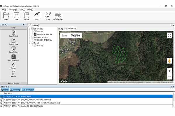
Hi-Target PPK GO precision add-on enables Phantom 4 RTK drones to achieve the accurate and reliable camera positioning data in any coordinate system without measure targets or ground control points. With 2-centimeter accuracies on XYZ, the output text file with position information or geotagged images can be used directly in major photogrammetric mapping or 3D survey software. The add-on allows selection of GPS/GLONASS/Beidou/ Galileo L1+L2+L5 and further parameter adjustments for position calculation in the PPK process to ensure the most reliable and accurate camera positioning even in poor single satellite system signals.
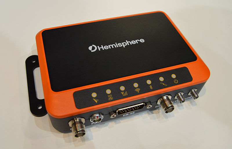
The R620 GNSS receiver is a complete refresh of Hemisphere’s previous version, the R330. (Photo: Allison Barwacz)
The next-generation R620 receiver is designed for land and marine applications requiring high-precision positioning. It is a complete refresh of the previous version (R330) and has a new low-profile ruggedized enclosure. Customers can start with sub-meter positioning accuracy and upgrade the receiver through activations and subscriptions to add functionality and improve performance capability to centimeter-level accuracy. Powered by the Vega series, the R620 GNSS receiver processes and supports more than 1,100 channels. It simultaneously tracks GPS, GLONASS, BeiDou (including Phase 3), Galileo, QZSS, IRNSS, SBAS and Atlas L-band corrections. It has status LEDs , a powerful WebUI, UHF (400-MHz and 900-MHz) radio, cellular modem, Bluetooth, Wi-Fi, Ethernet (including power over Ethernet), CAN, serial and USB.
For land surveying and geospatial information systems (GIS)
Photo: Geneq
The rugged SXPad 1500 data collector features an alphanumeric keypad and long-range Bluetooth, and was designed to meet the rigorous IP67 standard for challenging field conditions. It has a 5-inch sunlight-readable touchscreen. The SXPad 1500 can be connected to any GNSS receiver or compatible robotic total station. Driven by a 1-GHz processor and the Windows Mobile 6.5 operating system, providing the power to work with maps and large data sets in the field. Its integrated cellular modem and Wi-Fi provides wireless connectivity for internet access and GIS data transfer — helpful for configuring a real-time kinematic (RTK)-compatible GNSS receiver. Equipped with an internal memory of 1 GB (memory can be expanded to 16 GB with an SD card), the SXPad 1500 provides enough storage space for data recording. Its high-performance lithium battery allows uninterrupted field operation for up to eight hours.
The LT700H RTK Android tablet is designed to increase efficiency and productivity of the mobile field workforce in applications requiring centimeter-to-decimeter positioning accuracy. Portable, rugged and versatile, the LT700H enables precision GIS data collection, forensic mapping, construction site layout, environmental surveys, landscaping and earthmoving jobs. Powered by 184-channel high-performance GPS, GLONASS, Galileo and BeiDou module and a superior tracking GNSS helical antenna, the LT700H provides position availability in demanding environments. Its integrated 4G modem ensures seamless communication from field-to-office and robust connectivity to RTK correction networks.
The Trimble Alloy GNSS reference receiver now supports BeiDou Generation III (BDS-3) signals. This will enable operators to meet the ongoing demand from surveyors, mapping professionals and precision farmers for accurate, reliable corrections derived from real-time networks. Released in 2018, the Alloy has the processing power needed for high-quality data from multiple constellations. Alloy version 5.42 firmware tracks all available and planned GPS Block IIIA L1C and BDS-3 signals.
Hexagon showcased the Leica DSX utility detection solution at Intergeo 2019. (Photo: Allison Barwacz)
The Leica DSX utility detection solution can be used together with Leica GPS/GNSS systems to generate highly accurate, georeferenced maps. The DSX uncovers utilities for repair and maintenance, civil engineering and surveying projects. The ground-penetrating radar system includes portable hardware and software that automates data analysis and creates a 3D utility map.
uAvionix has received U.S. Federal Aviation Administration (FAA) approval for the Vehicle Tracking Unit (VTU-20) Automatic Dependent Surveillance – Broadcast (ADS-B) transmitter for airport surface management.
uAvionix is a designer and manufacturer of communications, navigation and surveillance (CNS) equipment for unmanned and manned aircraft.
Adhering to the performance and design assurance specifications of FAA-E-3032, the externally mounted VTU-20 ensures integration and interoperability with Airport Surface Detection Equipment, Model X (ASDE-X), Airport Surface Surveillance Capability (ASSC) and ADS-B receiver surveillance solutions for airport
surface control and situational awareness.
The VTU-20 can be permanently or magnetically mounted to all airside vehicles, including utility, emergency, snow-removal and maintenance equipment. Each vehicle is clearly and uniquely identified, providing an essential addition to any surface movement guidance and control system.
The VTU-20 implements FAA-approved Squitter Transmission Maps to automatically enable transmission on airport movement areas and disable transmission in low-risk areas or outside airport airside operations.
“Ground vehicle incursions into critical safety and movement areas is on the rise. With this achievement, uAvionix continues to promote safety and common situational awareness not only in the airspace but also on the airport surface,” states Christian Ramsey, uAvionix president.
This recent uAvionix achievement will be made available through an exclusive relationship with L3Harris Technologies, Inc., a leader in surveillance and air traffic management known for the Symphony product line of airport operations and environmental compliance solutions — to promote and sell the VTU-20 in the United States.