Topcon Positioning Systems attended GEO Business in London this month to showcase its latest solutions to improve survey and geospatial workflows.
The event, which took place at Excel London June 4-5, showcased hardware, software and workflow technologies across capture reality, surveying solutions, engineering surveys, and GIS mapping and utilities, including the company’s new suite of 3D scanning solutions. The scanning solutions offer integrated software that enables high-speed data capture and immediate analysis for a wide array of geomatics applications.
Topcon is partnering with Amberg Technologies on rail solutions. (Credit: Topcon)
“Smarter workflows for rail survey data”: Bruno Fileno, senior segment manager geomatics, gave an in-depth look at integration efforts between Topcon and Amberg Technologies that focus on how interoperable workflows streamline surveying tasks such as track alignment, geometry verification, and clearance assessment.
“Control, confidence, custody: How surveyors defend georeferenced SLAM workflows”: Phil Marsh, director of scanning sales EMEA, shared a practical framework for delivering georeferenced SLAM results, with tips on combining RTK with survey control and independent checkpoints, and building a lightweight QA pack to prove accuracy – producing outputs surveyors can get behind and clients can sign off.
“From ground to cloud: Transforming utilities with accessible digital workflows”: Nathan Ward, business development manager, utilities solutions EMEA, explored the newest innovations in utilities mapping, explaining how seamless data capture with the Topcon CR-H1 handheld device and automated cloud processing can deliver date-stamped records that cut delays, reduce rework, and speed up sign-off and payment.
New solution eliminates positioning errors in logistics, rail, and public safety by providing lane-level accuracy natively on rugged mobile devices.
Swift Navigation, a global leader in precise positioning technology, and RugGear, a manufacturer of rugged mobile devices for professional use, have joined to embed high-accuracy positioning capabilities into RugGear’s enterprise and mission-critical mobile devices.
The partnership integrates Swift Navigation’s Skylark Precise Positioning Service directly into RugGear devices built on the Qualcomm Snapdragon 6 Gen Platform. This native integration delivers reliable lane-level accuracy — an order of magnitude improvement over standard GPS — without requiring any external receiver or configuration. Precise positioning is available out of the box, ensuring seamless performance across rugged mobile form factors.
This integration is a major step in bringing high-accuracy positioning to industrial mobility. All location-based applications benefit automatically, meaning developers do not need to modify their existing apps.
Enhanced Capabilities with the RG940
The first device to integrate Skylark will be the RG940, a high-performance, rugged 10.1-inch tablet designed for demanding industrial uses. The high accuracy improves operational efficiency and accountability across enterprise segments, including:
Logistics and Waste Management. Optimizes routes, reduces fuel costs, and provides indisputable proof of service records for liability claims.
Construction. Provides a value-engineered approach for GIS mapping assets and enhances worker safety through geofenced “no-go” zones.
Rail. Enhances safety and efficiency for trains and prevents freight car loading errors.
Interested customers and partners are invited to contact RugGear directly for availability and technical specifications.
Siemens has unveiled its latest innovation for energy infrastructure: the Siprotec 5 Precision Time Protocol (PTP) Grandmaster Clocks (GMC).
Built to secure the backbone of modern power grids, the GMC ensures resilient, fail-safe time synchronization for digital substations, safeguarding critical protection functions from disruption, shielding against external disturbances, and strengthening cybersecurity to boost overall grid reliability.
Avoiding GNSS disruptions. Conventional digital substation architectures often rely on redundant GNSS-based grandmaster clocks. However, even with redundancy, they remain vulnerable: disturbances to GNSS signals, whether from natural phenomena like solar storms or intentional interference such as jamming and spoofing, can cause disruptive “‘jumps” in the time base. Such disruptions force merging units to resynchronize, temporarily disabling critical protection functions and can lead to unnecessary removal of equipment from service or even cause false tripping events, impacting grid stability and increasing operational costs. Siemens’ new solution mitigates these risks, ensuring uninterrupted, secure operation.
Siemens’ solution separates sample synchronization from global time synchronization using specialized internal time sources. The Siprotec 5 devices, equipped with integrated PTP Grandmaster Clocks compliant with IEEE 1588v2/PTP standard, operate independently from external GNSS signals, using internal oscillators as time references for precise synchronization.
Changeover technology. A key feature of this approach is Siemens’ patent-pending Seamless PTP grandmaster changeover technology, built into Siprotec 5 devices. This ensures that when primary clocks return, they first align with active backup clocks before resuming their role. In doing so, disruptive time base jumps during switchovers are prevented, keeping protection functions continuously available.
The specialized synchronization enables process bus networks in digital switchgears to operate autonomously without external access points, significantly strengthening cybersecurity by isolating the process bus from the station bus network.
ProStar Holdings is partnering with Tersus GNSS, a global manufacturer of patented GNSS technologies. ProStar is the developer of PointMan Precision Mapping Solutions and the LinQD enterprise integration platform.
The collaboration will deliver a complete precision mapping solution to the utility and critical infrastructure industries worldwide, the companies announced.
The partnership is designed to integrate Tersus’s survey-grade GNSS receivers with ProStar’s PointMan, providing an affordable, field-ready solution available through Tersus’s international distribution network. Tersus GNSS has operations in China, the United States, and Australia, and is recognized for its innovation in GNSS receiver and base station technology for high-precision positioning applications.
The collaboration represents the latest step in ProStar’s strategy to expand its partnerships through the LinQD open API integration platform, delivering its technologies in one connected precision mapping solution.
ProStar’s LinQD platform is designed to enable seamless interoperability between emerging technologies and legacy systems, creating a robust global ecosystem for geospatial intelligence. By uniting equipment manufacturers and service providers under this initiative, ProStar continues to strengthen PointMan’s position as a premier mapping solution for the critical infrastructure industry worldwide.
ProStar’s PointMan software will now be bundled with Bad Elf’s high-precision GNSS receivers for worldwide sales. PointMan Precision Mapping provides a powerful cloud and mobile precision mapping solution to surveyors and geospatial intelligence systems (GIS) professionals.
This strategic partnership expands the market reach of both companies and directly addresses the growing demand for a complete mapping solution in the utility and critical infrastructure industries.
By combining Bad Elf’s advanced GNSS receivers with ProStar’s patented precision mapping solution, utility owners, contractors, municipalities and engineering firms are able to capture, record and visualize the precise location of critical infrastructure at a low cost and with a complete solution.
Bad Elf delivers accurate, compact, lightweight and cost-effective GNSS solutions compatible with a broad range of third-party vendors. Together with PointMan, the bundled solution provides customers with a comprehensive, ready-to-deploy precision mapping solution designed to reduce costs, improve efficiency and accelerate industry adoption.
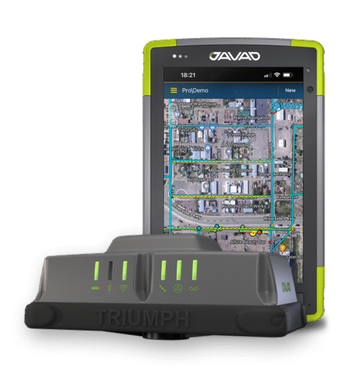
JAVAD GNSS and ProStar have announced an integrated collaboration for high-precision utility mapping and infrastructure asset tracking. The collaboration features JAVAD GNSS U.S.-made smart antennas and the mobile utility mapping software, PointMan by ProStar.
This strategic partnership expands the reach of both companies and addresses the growing demand for fully integrated and field-ready precision mapping solutions in the utility industry.
The combined solution pairs:
JAVAD GNSS smart antennas, designed and manufactured in the United States, delivering centimeter accuracy, multi-constellation support, and resilience in demanding field conditions.
PointMan by ProStar mobile software, a platform for mapping, visualizing and managing above- and below-ground assets in real time on standard mobile devices.
“Through strategic partnerships with leading hardware manufacturers like JAVAD, we are transforming the utility mapping industry,”said Page Tucker, CEO and founder of ProStar. “We see this as part of a growing trend in the industry where major hardware providers recognize they can create greater value for their customers by bundling our PointMan solutions with their hardware products.”
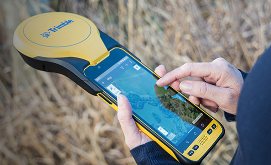
Trimble has announced a new high-performance data collector for its Mapping and Geographic Information Systems (GIS) portfolio — the Trimble TDC650 handheld. Built for GIS data collection, inspection and asset management activities, the TDC650 provides users a rugged solution with scalable high-accuracy GNSS positioning for professional field workflows.
The TDC650 is fully integrated with today’s demanding GIS data environment, powered by the Trimble Software Development Kit (SDK) that enables precision GNSS positioning for apps such as Esri ArcGIS Field Maps and Trimble TerraFlex software. The TDC650 is also a scalable solution that allows customers to choose their desired accuracy down to the centimeter-level to meet needs and budget requirements.
“This is an ideal tool for customers tasked with modernizing critical utilities including electric, gas and telecommunications networks,” said Gareth Gibson, marketing director, Trimble Mapping and GIS. “The precision, quality and data integration workflows needed to map the physical world to a digital one in these projects requires a modern data-collection platform like the TDC650.”
City, state and local governments and utilities will benefit from this solution, which is part of the larger Trimble Public Sector ecosystem that includes Cityworks software for stormwater inspections and Trimble Unity for monitoring municipal water pressure and hazards. As GIS data continues to grow more complex, Trimble helps simplify, visualize and make sense of the data so customers can make better decisions in managing their communities’ assets.
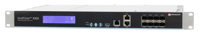
The GridTime 3000 GNSS time server meets rugged international environmental standards for power plants and substations
The GridTime 3000 GNSS time server. (Photo: Microchip)
Microchip Technology Inc. has announced its GridTime 3000 GNSS time server, a software-configurable solution providing power plants and substations with a new level of redundancy, security and resiliency to protect against surges, adverse weather and cyberattacks targeting critical infrastructure.
Meeting the Need
Power plants and substations rely on high-speed communications networks to transmit critical data including operability metrics, network health, fault monitoring, power measurement and usage trends. To synchronize communications and ensure continuity across these networks, substations require secure, precise timing and synchronization to avoid false tripping and to provide accurate time-stamping of substation data including system faults, power-measurement data and substation status information.
The launch of the Microchip GridTime 3000 GNSS Time Server assists power-grid operators to meet these requirements.
The GridTime 3000 system generates precise time and frequency signals to synchronize analog and digital communication systems. This resilient timing platform incorporates multiple timing inputs for protection in the event of a GNSS signal disruption caused by severe weather, environmental disturbances or signal jamming or spoofing.
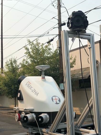
NV5 Geospatial has acquired the new Riegl VMX-2HA dual-scanner mobile mapping system. The system will initially deploy in utility and transportation projects and enable NV5 Geospatial to collect highly accurate, feature-rich data at highway speeds.
The flexibility, ease of setup, and smaller footprint will also allow the use of the VMX-2HA on various platforms, including boats, all-terrain vehicles and trains.
The VMX-2HA delivers mobile point clouds at a resolution of 1,000 to 4,000 points per square meter (pops) and 0.08-foot vertical accuracy in terms of 95% confidence intervals. It also features a high-speed 10 GigE link, which supports reliable data acquisition of up to 2 million measurements per second and image data from all integrated cameras.
NV5 Geospatial will launch the VMX-2HA as part of a mapping project for a large U.S. utility company and implement it for work being done for the U.S. Department of Transportation.
NV5 Geospatial has launched Trim Optimization, a predictive modeling platform that enables electric utilities to enhance vegetation management programs with risk-based assessments.
Using information from existing lidar and historical data, utilities can leverage Trim Optimization to prioritize tree-trimming activities by taking into account the risk posed by individual trees and other operational constraints.
“Trees are to blame for a large percentage of outages, and vegetation management is the single biggest cost for electric utilities. Yet, utilities have only started to look at proactive, risk-based management programs, rather than the traditional cycle-based ones,” said Ian Berdie, vice president of innovation for NV5 Geospatial. “NV5 Geospatial’s Trim Optimization platform will help utilities improve grid reliability through better decision making, while also saving them money through greater efficiency and the ability to target areas that have the most potential for problems.”
Vegetation is one of the largest sources of outages, accounting for more than half, according to a recent survey, “Geospatial Analytics, Resilience and Extreme Weather Readiness.” The majority of respondents also noted that they use data to analyze risk, but budget constraints often prevent them from investing in the data they need.
The trim optimization platform takes a phased approach to identify relative risk to target vegetation management work where it will have the most impact. With extensive expertise, NV5 Geospatial first identifies several attributes associated with vegetation-caused outages that can be modeled from high-density lidar and provide a relative risk score.
Utility-specific data, such as historic tree failures information or other factors, can be analyzed to enhance results further.
The final risk scores will provide a quantitative assessment of combined risk, enabling utilities to develop work plans that prioritize vegetation management mitigation efforts and result in greater operational efficiency.
NV5 is holding a webinar on Trim Optimization on Aug. 25. Register here.
Deal makes data from 40 Chinese satellites available through UP42 now, another 40 by late 2021
UP42 has signed an agreement with HEAD Aerospace of Beijing to make image data from more than 40 Chinese Earth Observation satellites available on the UP42 marketplace.
The broad selection of imaging capabilities from the constellations dramatically expands the range of applications in multiple sectors, with the most significant benefits expected in infrastructure, transportation, utilities, agriculture and government.
The UP42 marketplace contains more than 50 geospatial data sets, including satellite imagery from six international organizations. The newly added satellites’ diverse and often unique imaging capabilities include wide-swath imaging at very high resolution, nighttime acquisitions, frequent intraday revisits, tri-stereo collection and hyperspectral imaging.
“This partnership is an important milestone for us as a company but, more importantly, for our customers. By diversifying our data sets, we are unlocking a broader spectrum of use cases for our users in multiple sectors. This is the true meaning of ‘democratizing access to Earth insights’,” said UP42 CEO Sean Wiid.
HEAD Aerospace is an international distributor of satellite imagery collected by commercial Earth Observation missions. The UP42-HEAD agreement includes imagery from multiple constellations, including SuperView, Earthscanner, Gaofen-7, DailyVision, NightVision, Hyperscan, and Tri-Stereo ZY3. These seven constellations will total more than 80 satellites by the end of 2021.
“Sharing a similar approach facilitating users’ easy access to an agnostic data source by a centralized portal with a wide choice of satellite attributes, we are glad to have partnered with UP42. This partnership represents another new milestone for us in expanding our global network.” said Kammy Brun, managing director of HEAD Aerospace.
While each satellite constellation was designed with one or more imaging specialties, a remarkable variety of operational capabilities are shared across the constellations to support numerous applications and industries. Examples include:
Large-Area Very High-Resolution Mapping – Planning and monitoring critical infrastructure, including utility transmission grids and transportation networks, can be performed for entire states, countries and regions. Up to 40,000 square kilometers can be covered with wide-swath (136 km) imagery captured at a half-meter spatial resolution on a single pass.
Intraday and Early Morning Monitoring – The EarlyEye tasking product leverages multiple HEAD Aerospace constellations to deliver early-morning frequent images, an hour earlier than usual commercial offer at 10:30 a.m. Designed for frequent monitoring of critical assets and rapidly changing situations related to energy security, defense/intelligence and infrastructure management, a high-resolution revisit schedule of four times per day is possible, with 15-minute revisit between 09:00 and 13:30 anywhere on Earth to be possible by the end of 2021.
High Vertical Accuracy Mapping – Multiple satellites perform stereo imaging at high resolution for high-quality land use and cadastral mapping. One constellation captures single-pass tri-stereo imagery validated with onboard laser altimetry data, generating digital elevation models (DEMs), digital terrain models (DTMs), and other large-scale 3D mapping products with vertical accuracy of 5 meters. Additionally, the SuperView constellation captures daily stereo imagery with vertical accuracy of better than 2 m.
Hyperspectral Imaging – Imaging in 25 spectral bands spanning the visible, near-infrared, and mid-infrared portions of the spectrum is designed for regional natural resource management: detecting crop stress and planning pesticide/fertilizer applications, species mapping of forests and vegetative land cover, and protecting environmentally sensitive areas. These data sets can also be used in agriculture monitoring, mineral exploration and water-quality monitoring.
Nighttime Imaging – Monitoring and surveillance activities by government entities, energy utilities and security organizations can be carried out around the clock with true-color, high-resolution at 1 m optical and video imaging during daylight and dark of night. Nighttime collection is suitable for surveillance such as illegal camping, border surveillance, change detection (especially in rapidly evolving events), powerline incidents and designing streetlight placement in urban settings. Day and night video can detect vehicle and ship movement.
UP42 users have a growing selection of satellite imagery to choose from on the geospatial marketplace. UP42 technical experts are available to assist customers in selecting the best data set to meet the needs of specific end-use applications in all industries and sectors. These experts can also help in tasking a satellite for new image acquisition or querying the archive to obtain existing imagery.
Auterion, an open-source drone software platform provider, has partnered with C2 Group — a program, project and construction management firm — to power the use of drones for inspection, mapping and disaster response across the utilities and critical infrastructure industries.
The collaboration has been formed after C2 Group conducted extensive testing of the Vantage Robotics Vesper drone powered by Auterion to inspect power lines at its UAS testing ground and assess viability within the utilities space.
Auterion and C2 Group have seen a shift in the utility industry to move away from drones manufactured overseas to focus on the adoption of U.S.-made products such as the Vesper, a Blue sUAS-certified product used by the U.S. military.
Features on the Vesper that the utilities industry can use include high-quality sensors and thermal capabilities, while its stability and lightweight design make it rapidly deployable.
Utilizing the data security, quality and flexibility enabled by Auterion across multiple UAS manufacturers means C2 Group pilots can be trained on one flight platform but fly any drone associated with it; reducing the training time and increasing overall productivity. Further productivity measures are achieved with Auterion’s Suite used to identify pilot efficiencies and its Simulator to augment pilot training. At the same time C2, with its industry knowledge having worked with multiple major utilities in the US, is providing insight that is helping to shape Auterion’s roadmap for new sensors and airframes into the future.
Brandon Del Priore, CTO at C2 Group, said: “We are proud to partner with Auterion to bring some of the best technology developed in the US to our clients in the utilities and critical infrastructure industries. When safety, data security, and data quality matter most, C2 Group will be there to offer customers the same US-made hardware and software used by the DoD’s Defense Innovation Unit and the US military. The open source ecosystem is helping to drive a better footprint within the marketplace and a better level of compatibility for US made products.”
Cynthia Huang, VP Enterprise Business Development at Auterion, said: “With DJI added to the entity list, we’re seeing enterprise drone operators accelerate their search for alternatives. Auterion’s open source software ecosystem provides more options, more solutions, and faster development timelines to the needs being identified today and companies are embracing the power of our approach. We are excited to partner with C2 Group to bring US made solutions and the advantages of open source to their customers.”
For more information, visit www.auterion.com/enterprise