Applanix has introduced POSPac MMS v6.2, its latest generation of software for directly georeferencing mobile mapping sensors using GNSS and inertial technology. Featuring new Applanix IN-Fusion Multi-Single-Base Processing, POSPac MMS V6.2 is designed to improve the productivity and accuracy of mapping from mobile platforms in the air, on land or at sea, the company said.
IN-Fusion Multi-Single-Base Processing is designed for customers who need the highest level of differential GNSS position accuracy and perform long, linear projects such as power-line corridors, long highways or stretches of coastline. During these projects, a GNSS base station network may not be available, or the geometry of the network so weak that an Applanix SmartBase solution — which uses existing reference stations to achieve high accuracy over longer distances — is not viable. In these cases, IN-Fusion Multi-Single-Base Processing allows base stations to be established along the full length of the travel path and makes optimal use of the nearest base station at all times.
Customers can now take advantage of robust tightly coupled in-fusion processing without the need to break the project up into multiple segments for each base station to attain the highest accuracy, Applanix said.
“In addition to IN-Fusion Multi-Single-Base Processing, POSPac MMS V6.2 includes new features designed to increase productivity, efficiency and ease-of-use. The Coordinate Conversion tool included allows users to choose from a number of local reference frames for inputting base station coordinates,” said Edith Roy, Development Manager of POSPac MMS at Applanix. “POSPac MMS Version 6.2 demonstrates our commitment to providing customers with not only the most advanced software solutions for mobile mapping applications, but also the easiest to use.”
POSPac MMS V6.2 can be purchased through Applanix’ global sales network. The software is available as an upgrade to all POSPac users currently under a maintenance contract.
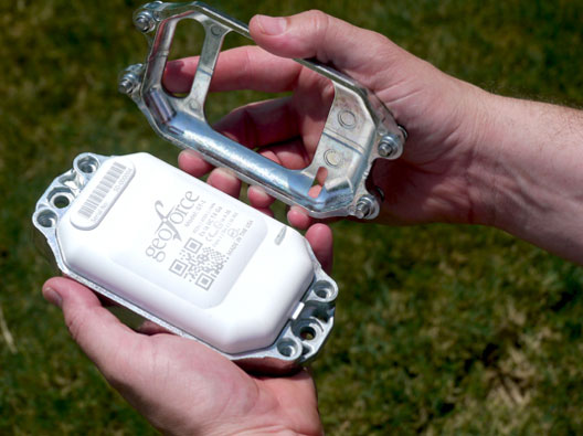
GT-1 asset tracker combines GPS, RFID, and Bluetooth technologies. Photo: Geoforce
Geoforce, Inc. is announcing commercial availability of its GT-1 asset tracking device that can track field equipment in locations and conditions previously too challenging for other devices to function effectively. A globally certified GPS device, the GT-1 enables oil and gas service providers to proactively monitor and share data on vehicles and equipment for more cost effective operations, helping to meet ongoing environmental responsibilities, the company said.
“We have been waiting a long time for a device like this,” said Michael Rolston, operations manager at Permian Equipment Rentals. “It’s small, it’s incredibly rugged, it will last years without replacement. It’s also surprisingly low cost — given all its features and capabilities.”
The GT-1 was previously offered in limited release to several major international service and rental companies beginning in the fourth quarter of 2012. To date, thousands have shipped and are actively tracking oilfield assets around the globe.
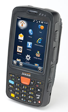
Janam Technologies LLC, a provider of rugged mobile computers that scan barcodes and communicate wirelessly, today announced the release of its new XT85, a high-bandwidth wireless rugged mobile computer designed to support demanding enterprise applications in equally demanding outdoor environments.
Janam’s XT85 offers a complete set of features that enterprises require in a rugged wireless wide area device, at a price point that makes extending enterprise mobility affordable, Janam said. It is equipped with high-sensitivity GPS with anti-jamming technology.
The XT85 survives multiple 5-foot drops to concrete at temperature extremes (and 6-foot drops at room temperature), offers a 3.5-inch high-transmissivity display that maximizes outdoor readability while minimizing power consumption, offers advanced 4G-ready cellular network connectivity with five-band UMTS for global roaming, and is small and lightweight.
“Purpose-built mobile computers must appeal to today’s information worker who expects a device that is small, light, fast and highly capable while also serving the business needs of the enterprise for whom the mobile worker is performing mission-critical tasks,” said Harry B. Lerner, CEO of Janam. “Janam’s XT85 is optimized to appeal to both constituencies. It’s much more than a smart phone. It’s a brilliant PDA.”
In addition to 4G-ready UMTS/HSDPA/HSUPA/GSM wireless wide area network communication, the XT85 is equipped with 802.11 a/b/g/n WLAN with enterprise-grade security and Bluetooth. It is available with the SE965HP laser engine from Motorola or Honeywell’s Adaptus Imaging technology. Purpose-built to accommodate the realities of work processes and environments, the XT85 is UL-certified for use in hazardous environments, sealed to IP65 standards and available with QWERTY or numeric keypads.
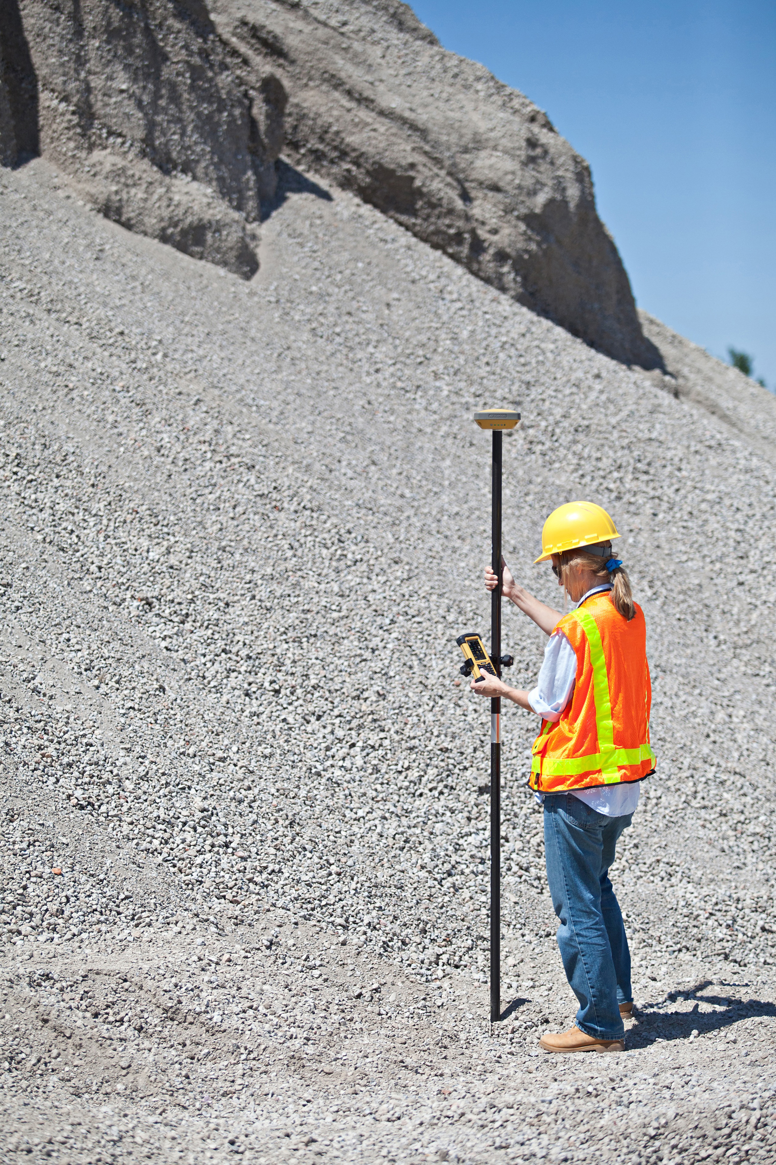
With the introduction of a new version of Pocket 3D software for its HiPer SR GNSS receiver, Topcon Positioning Systems is expanding the delivery of high-accuracy 3D positioning technology to contractors needing a low-cost, one-man layout and measurement system.
Pocket 3D is powerful, easy-to-use data collection and control software for grade checking and other measurement applications on a job site. Version 10.0.2 makes it fully functional with the HiPer SR receiver, introduced in August.
The new receiver is not only “perfect for contractors, but also for other non-traditional GNSS users such as landscape architects, law enforcement forensics projects or any others requiring high-accuracy 3D positioning,” said Tony Vanneman, Topcon construction products marketing manager.
Its field-rugged and fully-integrated design delivers a 1,000-foot working radius through Topcon’s new LongLink technology. “This innovative wireless data link was developed specifically for the HiPer SR, and provides reliable and interference-free base-to-rover communications that don’t require an FCC license to operate,” Vanneman said.
“We took the best signal tracking technologies and packaged them in a small, energy-efficient design,” he said. “Anyone looking for a rugged, easy-to-use, low-cost 3D GPS system will find what they need in the HiPer SR.”
Additional key features of the HiPer SR include:
Shock-resistant magnesium alloy housing – allowing the HiPer SR to take a 6 ft. (2m) pole drop onto concrete;
ALK Technologies CoPilot Live software enables OEMs to bring own-brand turn-by-turn navigation apps to market.
Trimble has announced that it has acquired privately-held ALK Technologies Inc. of Princeton, New Jersey. ALK Technologies specializes in routing, mapping, mileage and navigation technologies. ALK Technologies offers proprietary routing and international map-based solutions for transportation, logistics and mobile workforces.
The addition of ALK is expected to extend and complement Trimble’s Transportation and Logistics product portfolio, including TMW Systems’ transportation management solutions, PeopleNet’s integrated onboard computing and mobile communications systems, and GEOTrac’s fleet management and worker safety solutions for the oil and gas industry. Financial terms were not disclosed.
ALK software products include CoPilot Live, which offers onboard GPS navigation for professional drivers, and PC*MILER, a truck-specific mileage solution recognized as an industry standard for logistics, manufacturing, government and transportation operations. ALK offers a consistent data platform for operational planning activities, such as mileage and routing and in-cab navigation applications used by fleet drivers. ALK products are sold worldwide and feature extensive international map data. Approximately 64 percent of North American for-hire motor carriers use ALK solutions, including 98 of the top 100 largest for-hire carriers, 47 of the top 50 logistics companies and 77 of the top 100 private fleets.
“The addition of ALK Technologies expands the portfolio and scope of innovative solutions we can offer transportation providers, logistics companies and shippers,” said David Wangler, president of TMW Systems, a Trimble Company. “The combination of ALK’s routing, mapping, mileage and navigation capabilities with our enterprise transportation management software and the mobile communications solutions under the Trimble Transportation and Logistics umbrella supports our comprehensive and industry-focused technology approach.”
“This is a significant milestone in ALK’s long history in transportation,” said Barry Glick, president of ALK Technologies, who will continue to lead the organization. “We are excited to join our well-known and respected partner TMW Systems under the global umbrella of Trimble. These organizations share our passion and vision for how location information can transform business and productivity.”
ALK Technologies business will be reported as part of Trimble’s Mobile Solutions segment.
Trimble introduced today the Yuma 2 rugged tablet computer, which it says is a powerful mobile computing solution that provides full office capabilities in the field for construction, transportation, public safety, field service, forestry, utilities, mapping, insurance and any other outdoor or service-related industry.
The Yuma 2 offers a seven-inch capacitive multi-touchscreen in an easy-to-hold form factor that measures 6.3 x 9.6 inches, and weighs less than three pounds. Featuring new display technology for clearer readability in direct sunlight, the Yuma 2 can be used by mobile workers in the brightest outdoor conditions. The 3.75G dual-mode cellular data capability enables connectivity anywhere GSM or CDMA cellular networks are available.
Featuring the Microsoft Windows 7 Professional operating system, the Yuma 2 is a fully functional field computer with a 1.6-GHz Intel Atom dual-core processor, 4 GB of DDR3 DRAM, a 64-GB solid state drive (SSD), and a dual battery with eight hours of typical run-time. Optional features include a 128-GB SSD, 3.75G cellular data connectivity and an extended battery set that provides up to 16 hours of operation.
With the multi-touch capacitive touchscreen, users can type with fingers, stylus, or capacitive gloves and can control the size of the keyboard on the display for ease of use. Controlled zoom can optimize the user experience with maps and detailed information. The display supports use in landscape or portrait mode and is configurable to hold the orientation or to alter it in response to the accelerometer. The 5-megapixel camera provides video and photo capture with geotagging. The GPS receiver provides 2 to 4 meter accuracy, and is designed for data collection in applications such as distributed asset management, work order management, fleet logistics and more.
“Ruggedness and connectivity in the field are vital for mobile workers — and Trimble has a history of providing innovative computing solutions to the market,” said Jim Sheldon, general manager of Trimble’s Mobile Computing Solutions Division. “Today, users demand solutions that are even tougher, faster, more reliable and easier to use, so they can be more efficient and productive. With new features and functionality, the Yuma 2 is an ideal solution that provides even more computing power to mobile professionals — more memory, computing speed, drive capacity, connectivity options and better display readability.”
As with other Trimble rugged mobile computers, the Yuma 2 meets stringent MIL-STD-810G military standards for drops, vibration and humidity; and with an IP65 rating, it is protected against dust and water.
Four different configurations are available to provide the tablet that meets the right need at the right price. Options include a larger SSD and 3.75G GSM and CDMA cellular data capability, as well as three different color schemes.
The Trimble Yuma 2 tablet computer is expected to be available early in the fourth quarter of 2012.
Trimble introduced today the Trimble Geo 5 and Juno 5 handheld GNSS devices, further extending Trimble’s portfolio for data collection, maintenance and inspection applications. The Geo 5 and Juno 5 series are both optimized for GIS field workflows, including Trimble’s TerraSync field software available on all Trimble GIS platforms.
Since 1994, the Trimble GeoExplorer line of GNSS handhelds has been used for professional GIS data-collection applications. While the GeoExplorer 6000 series is the most capable Trimble handheld for GIS data collection, not all customers require the larger screen and innovative Floodlight technology of the 6000 series. The Geo 5 provides the essential functions for all day, submeter productivity in a smaller package, Trimble said.
The Trimble Juno product line is used worldwide for maintenance, inspections and asset management applications. With the addition of the Juno 5 series, Trimble is providing a rugged handheld that delivers the capabilities and convenience of a smartphone, Trimble said. The Juno 5’s slim, ergonomic design is thinner and lighter than other rugged computing products in its class today and provides a more advanced feature set than the Juno 3 series.
“Whether users are engaged in initial data-collection tasks or inspection of assets, it is critical they have a complete solution they trust,” said Daniel Wallace, general manager of Trimble’s GIS Data Collection Division. “Now with two platforms in both the Geo and Juno families, customers can confidently choose a handheld that best fits their needs. Trimble TerraSync software is the unifying workflow that brings these choices together, so customers can always trust the quality of their data throughout the complete lifecycle of a field management project.”
Complete with wireless communications options, integrated cameras and bright, sunlight-readable screens, both devices are built for work in the field and rugged enough to withstand shock, vibration, water and dust.
The Earth’s surface is constantly shifting, being deformed as earthquake faults accumulate strain, and slip or slowly creep over time. Not long ago, scientists relied solely on seismometers to monitor the earth’s movements. Today, GPS has taken prominence as an indispensible tool.
PANGA, the monitoring network covering the Pacific Northwest, uses GPS to monitor this movement by measuring the precise position (within 5 millimeters or less) of stations near active faults relative to each other. By determining how the stations have moved, ground deformation can be determined.
If the plates near the coast or the Cascade Mountains move even a few centimeters, the scientists at PANGA know within seconds. The network is still being built, but eventually it’s expected that PANGA will be able to sense earthquakes faster and more accurately than traditional seismometers, and issue alerts to warn citizens of impending activity.
“GPS is helpful in distinguishing magnitude 8 from M9 earthquakes quickly,” explained Rex Flake, PANGA. “By design, seismometers only record high-frequency energy that becomes saturated during strong ground motion. Moreover, seismic data ‘clip’ at high magnitudes whereas GPS become more accurate. Seismographs are mainly intended to detect very small to moderately large earthquakes. GPS gives actual ground motions that in theory could be incorporated very quickly into tsunami models and warning systems. That is one of the things we are working on now.”
Volcano Watch. “A more speculative application is that some (not all by any measure) large earthquakes are preceded by slow creep events,” said Andrew Miner, PANGA. “While not really good enough to predict an earthquake, I think if we saw a very large transient creep event it would at least ring alarm bells. Unfortunately though, earthquakes are by their nature just not very predictable, at least to the level of a day or week that people could reasonably act on. On the bright side, volcanoes are reasonably predictable, and GPS is also an important tool in monitoring them. We work with the Cascade Volcano Observatory on several monitoring projects.”
PANGA is one of a series of earthquake monitoring networks stretching along the West Coast. The Pacific Northwest Geodetic Array is run by the PANGA Geodesy Laboratory at Central Washington University (CWU) in Ellensburg, and includes 300 continuously operating, high-precision GPS receivers located throughout the Pacific Northwest. Sixty more stations are expected to be installed this year. Trimble, Leica, Topcon, and Javad are the main receivers used in the region.
Data from these receivers is continuously downloaded, analyzed, archived, and disseminated. About one third of PANGA’s GPS stations are telemetered in real-time back to CWU, where the data are processed using NASA’s Jet Propulsion Laboratory’s GIPSY/OASIS II software for high-precision data analysis, and Trimble’s RTKNet Integrity Manager software for real-time analysis. The data provide relative positioning of several millimeters across the Cascadia subduction zone and its metropolitan regions. These real-time data are used to monitor and mitigate natural hazards arising from earthquakes, volcanic eruptions, landslides, and coastal sea-level hazards.
Sagging Bridges. The data are also used to monitor man-made structures such as Seattle’s sagging Alaska Way Viaduct, the State Route 520 and Interstate 90 floating bridges, and dams throughout the Cascadia subduction zone, including those along the Columbia River. For instance, for the S.R. 520 bridge, PANGA teamed up with Washington State Department of Transportation (WSDOT) to monitor movement of the 520 bridges during wind storms and seismic events.
The receivers continuously monitor and record structural deformation with about a millimeter precision. Raw GNSS satellite phase and pseudorange estimates are acquired and processed continuously into receiver positions estimated every 5 seconds and delivered with 10 and 30-second latencies. Daily-averaged receiver positions computed with predicted and post-processed satellite orbit and clock corrections are provided with 1-6 day latencies.
Seattle’s aging Alaska Way viaduct is one of several major man-made structures being monitored by PANGA’s GPS Network. (photos courtesty of CWU Geodesy Lab.)
Tremor Slips. The Northwest is at the forefront of earthquake-related GPS research, in large part because the area provides a lot to learn from GPS monitoring, Flake said. “For example, when we started it was strongly suspected but not definitely known that the Cascadia subduction zone was locked over parts of its surface and a major earthquake threat. Thanks to GPS monitoring we now have a pretty good idea not only exactly where it is locked, but also when parts of it do slip or creep.
“One important discovery made with GPS data, along this line, was that of the Episodic Tremor Slip (ETS) events that occur here in the Northwest U.S.,” Flake said. “Since the time duration of ETS motion takes place on the scale of days to weeks, these earthquake events were unrealized by traditional seismic detection methods.”
GPS data shed light on this peculiarly predictable earthquake phenomenon. “With these GPS data we can measure strain accumulation within the continental crust (where people live) and calculate the residual that can be expected to rebound in a large subduction zone earthquake,” Flake said.
“Even more detailed than that, we can use GPS data from past ETS events to constrain the locked zone of the subducting crustal plate by inferring the amount of slip at depth that best reproduces the observed GPS recordings — important in determining possible magnitude and location of the megathrust earthquakes (Mw = 8 to 9) that will someday occur. This is of obvious concern to society and is a major reason that we lead the geodetic applications of GPS research.”
Data Online. PANGA maintains a website that integrates daily GPS measurements from about 1,500 stations along the Pacific/North American plate boundary, ranging from Alaska to the U.S-Mexico border. Cleaned, network solutions from several arrays are merged and grouped into regional clusters.
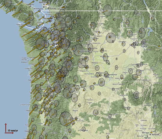
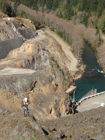
Arrow on a Velocity Field Map of Oregon and Washington represent ground motion as measured by GPS at each particular location. The grey circles are 2 sigma error ellipses (click to enlarge.) (photos courtesty of CWU Geodesy Lab.)The PANGA team constructs a bedrock drill-brace geodetic monument at Howard Hanson Dam east of Auburn, Washington. (photos courtesty of CWU Geodesy Lab.)