An old adage says, “Be careful what you wish for, you might get it.” That is particularly relevant in today’s world of GPS and the positioning, navigation, and timing (PNT) dependencies it has created. In business, it’s all about location, and in military circles, something called real-time situational awareness, driven by the ready availability of PNT from GPS. However, it has been reported (and validated by experience) that U.S. soldiers believe that the GPS equipment they are issued through official channels is too big, too heavy, uses too many batteries, and is old-looking and not sexy like the multi-color, multi-app personal electronics and smart phones they are accustomed to at home.
Furthermore, they reportedly feel encumbered by Department of Defense (DoD) policies that require the use of encrypted military GPS signals when executing combat mission command-and-control or performing combat-related actions such as synchronizing tactical networks, designating targets, and calling for fire support when in contact with an adversary force. They wish they could just use their iPhone, or iPad, or similar smart device with its integral location-based apps and ready communication capabilities, and not have to deal with what many see as obsolescent gear and antiquated policies. Unfortunately, were that wish to really come true across the joint force and mission domain, it could have disastrous and deadly consequences.
This is not intended to be a defense of the DoD requirements and acquisition processes, for there is much that could be improved within both. Adherence to those processes in the procurement of PNT equipment means that it will take longer to develop and produce the equipment than comparable commercial units, and that the equipment will probably be heavier and less user-friendly than commercial products.
However, those processes exist and are rigorously followed, first because they are required by statute, but also for practical reasons of justifying investments of taxpayer resources and ensuring as much as possible that whatever is procured will withstand the rigors of service in its intended military application. For GPS equipment, this includes not only the rigors of the physical environment but also those of the electronic environment, including threats of both unintentional and hostile interference and signal imitation. It is precisely that threat environment that presents the greatest danger to reliance on commercial GPS products in military applications.
The U.S. military and coalition forces have been fortunate from a PNT perspective over the last couple of decades in facing relatively unsophisticated adversaries with either limited access to or limited desire to routinely employ PNT countermeasure technology. Consequently, we have seemingly become complacent to the risks posed by overreliance on commercial-derivative PNT products. This complacency is apparent in the recent reporting from the Army’s forward-leaning Network Integration Evaluation (NIE) program, in which the Army assesses leading-edge commercial technologies and identifies those with great promise in order to fast-track them into operation, bypassing as much as possible the aforementioned DoD requirements and acquisition processes.
At the same time, the Army gives a wink and a nod to the GPS security policies requiring use of encrypted military GPS signals for combat operations. It is a virtual certainty that if GPS drives the location-based applications in the commercial-derivative technologies evaluated by NIE, those applications are all powered by civilian GPS and not the encrypted military GPS. As noted, civilian GPS is frequently seen by those not thoroughly familiar with PNT technology as the cheap, expedient choice because more secure or integrated PNT sources are too expensive, too heavy, too much bother, and so on.
It is also apparent, though not confirmed, that during NIE field testing, the opposing force toolkit does not include navigation warfare (NAVWAR) techniques for GPS jamming and spoofing. If it did, and if the test scenarios included active GPS jamming and spoofing, then the commercial location-based apps with civilian GPS as their input would not work or would derive erroneous solutions. In that case, the Army might have to reconsider its rapid deployment decisions for these vitally important devices. Clearly, it is not doing that.
The highly touted Rifleman Radio, advertised by the Army as a success, uses civilian GPS as its source of PNT information. The Army is planning to deploy tens of thousands of these radios for operational use over the next several years. While soldiers may be told or even admonished not to use the position and timing solutions derived from these radios for other than situational awareness — in other words, not to use them for direct combat or combat-support tasks — the likelihood of that policy being followed in the real world is nil. Either of necessity or for convenience, soldiers will use what is made available to them for whatever purposes they deem appropriate. That will be true whether the commercial-derivative PNT solution is in a smartphone or a Rifleman Radio.
For the near term, that may not be a problem. However, at some point, in a contested environment against a knowledgeable adversary, mission effectiveness will be compromised and soldiers’ lives will be endangered by such devices. Further, proliferation of these devices will constrain our own commanders in their ability to employ offensive NAVWAR techniques that might be necessary to disrupt adversary use of open civilian GPS signals against our forces in the combat theater.
These statements are not mere speculation. The vulnerability of civilian GPS signals to unintentional interference and intentional jamming is well known. Reports of personal privacy devices interfering with reception of civilian GPS signals at Newark Airport provide a recent example (see “Personal Privacy Jammers,” page 28 in this issue). What is less well understood, but even more sinister in a combat environment, is civil GPS susceptibility to spoofing: the intentional creation of false, but believable, signals.
In a recent interview with Fox News, Todd Humphreys, a well-regarded GPS researcher from the University of Texas, stated, “The civil GPS signal is completely open and vulnerable to a spoofing attack, because they have no authentication and no encryption. It’s almost trivial to mimic those signals to imitate them and fool a GPS receiver into tracking your signals instead of the authentic ones.” In a combat environment, such deception could result in mission failure or loss of life through loss of command-and-control communications in high tempo lethal actions, erroneous target designations, or misdirected fires.
All those who recommend providing soldiers in combat situations with PNT capabilities derived from civilian GPS, whether via smart phone, iPad, or Rifleman Radio, in lieu of or even in addition to their less convenient but more reliable military GPS devices, should reconsider that recommendation in light of the above.
There is no argument to the statement that the DoD owes the warfighter more modern, integrated, compact, battery-efficient PNT devices incorporating military GPS. Those will come through the acquisition process, though not as fast as we all would like. In reality, a proliferation of civil PNT devices in military operations will likely delay further the availability of more suitable integrated military equipment.
In the meantime, we should not be misled because of our experience in today’s war. Instead, we must plan for future actions in anti-access/area denial situations against knowledgeable adversaries. We cannot afford to undermine the warfighters’ cause in advance by advocating reliance on vulnerable and exploitable commercial GPS equipment that can get them killed.
Jules McNeff is vice president for strategy and programs for Overlook Systems Technologies. He served 20 years in the U.S. Air Force, and then was responsible for Defense Department management and oversight of the GPS program. He is a charter member of GPS World’s Editorial Advisory Board.
I brushed the snow from the XRW keyboard and in my mind I could hear the neighbors whispering, “Call the men in white coats, there he goes again.” And actually there may be reason for concern, as I am sitting on my deck during a lull in a major blizzard and typing on a laptop computer half buried in snow. But not just any computer.
I am composing the beginning of this month’s column, the words you are reading now, on the Algiz XRW built in the non-tropical Swedish paradise known as Lidköping (which must mean something like “coping by the frozen lake”), and brought to you by the folks at Handheld US. Of course, I know — or certainly hope — my neighbors are not really calling anyone to come take me away to a little padded room because for them my once-strange behavior should by now be almost commonplace. Like swallows returning to Capistrano, when it snows in the Rockies I can be found on my deck with several new devices: dropping them in snow banks and freezing pools of water, and generally putting them through their paces. Where I live in the Rockies, we are eligible for snow 12 months out of the year, so this is not an uncommon occurrence. There are lots of opportunities for testing supposedly rugged devices.
Unfortunately, only about one in ten survive this tortuous treatment, and those are the ones you read about in this column. Remember, my rules of engagement (ROE) are that I only review top-notch products that our warfighters and first responders can use. I never pen a negative review unless it is a comparison evaluation where one of the products is clearly inferior. These inferior products, the ones I don’t write about, are returned to the manufacturers in various states of disrepair. Frankly, I am amazed and disturbed by the huge number of substandard and sometimes just poorly conceived “rugged” laptops on the market. Fortunately, the XRW is not one of them. Indeed, as a rugged GPS-enabled Windows laptop, it rises above the herd of less capable machines and demonstrates that a great device can be produced with just a little, or in the case of the XRW, a lot of planning and forethought, and be genuinely useful to our warfighters and first responders.
The XRW being put through its paces during a lull in a Colorado Blizzard.
Why Test?
I decided to test several rugged laptops during our latest blizzard. A full 20 percent of my warfighter correspondence indicates that there are just some warfighting computer tasks more suited to a rugged laptop than a rugged handheld device.
One of the greatest weaknesses and strengths of current military user equipment (MUE), and be assured it is only one of many, is that the mission planning software requires a separate Windows computer to fully plan missions and download numerous waypoints. The only upside is that, certainly speaking generically, it is usually more convenient and more comfortable to make changes on a laptop versus a rugged handheld. The problem comes with the restriction that this is the only way to make major mission changes to your government-furnished PNT (position, navigation and timing) device. If the mission changes in the field, which happens more often than not, about 90 percent of the time according to warfighters, then you need a rugged laptop in the field to update or change the mission coordinates that are input into the extremely outdated government-furnished GPS device. So for the warfighter, since a laptop is required to make changes, it makes sense to use a rugged laptop or notebook computer to do the updating in the field. Having said that, and considering that in Afghanistan there are really no front lines, everyone is in the field in some respect, I suspect the perceived need is actually very real. Employing a rugged laptop or notebook that actually has an excellent inherent GPS capability adds a layer of familiarity and comfort as well as necessity; consequently and for good reason, many of our warfighters feel strongly that they need a rugged laptop, so a search and subsequent blizzard testing commenced.
Handheld US produces several mil-spec rugged
devices. We have put many of them through
their paces over the last several years.
The Algiz XRW, henceforth referred to as the XRW, passed all the mil-spec tests with flying colors, but there was one test event that provided a result I have never before encountered — the first time I dropped the XRW into a snow bank from about five feet up, it hit a hidden rock and the keyboard popped off. I was surprised and a bit disappointed, until I realized this was a design feature, not a fault. The keyboard is connected via an electrical connection that does not alter the imperviousness of the laptop case, ensuring the XRW is immune to water and dust. I simply reinserted the keyboard; it popped back in place very easily, and it has been functioning perfectly ever since.
There really is a keyboard underneath all that snow and the XRW is running applications
as it gets cold soaked for further mil-spec testing.
The XRW is truly a rugged laptop with a keyboard that can take everything you can throw at it. As you can see in several of the pictures, the keyboard is covered in fresh snow while I allowed the XRW to cold soak and repel moisture for over an hour with no ill effects. Everything still functions perfectly. And I must admit the XRW keyboard has a nice feel, almost as good as the Apple keyboard I use daily, and that from me is high praise indeed, as I freely admit that I am enamored with the touch and feel of Apple keyboards.
The XRW running applications while embedded in fresh Colorado snow. Note the leather
strap on the left side of the XRW that can be used as a handhold or as an attachment point
for a lanyard, a warfighter requirement.
The XRW is probably more correctly called an ultra-rugged notebook, but most notebooks don’t have touchscreen capabilities. Whether you choose to call it a laptop or notebook, it is extremely rugged. Its size and capabilities make it very well suited for use by warfighters and first responders, as you can see by reviewing the following specifications that include very stringent MIL-STD (military standard) specifications:
Algiz XRW Specifications
Size
260mm x 178 mm x 40 mm (10.2″ x 7.0″ x 1.6″)
Weight
1.5 kg (3.3 lb)
Environment
Operating: -20 °C to 55 °C (-4 °F to 131 °F) MIL-STD-810G, Method 501.5
Procedure II, MIL-STD-810G, Method 502.5, Procedure I, II, III
Storage: -40 °C to 55 °C (-40 °F to 131 °F) MIL-STD-810G, Method 501.5
Procedure II, MIL-STD-810G, Method 502.5, Procedure I, II, III
Drop: 26 drops from 1.22 m (4 ft) MIL-STD-810G, Method 516.6, Procedure IV
Vibration: MIL-STD-810G, Method 514.6 Procedures I & II, General minimum
At just over three pounds, the XRW is easy to hold and has a side strap with a leather Velcro cover that is easily adaptable to attaching to a warfighter via a lanyard. This allows the warfighter to instantly drop the XRW and bring his or her weapon to bear without ever worrying about the rugged notebook hitting the ground. I tested this scenario several times and the side strap held up well. The computer was no worse for wear, mainly because it is rugged and has a 64-GB solid-state drive — in other words, no moving parts. The lanyard and instant-drop capability is fast becoming a requirement or “must have” among our warfighters, and the XRW meets the requirement handily.
Another warfighter requirement, especially in the mountains of Afghanistan, is that the MaxView Technology 10.1-inch touchscreen be usable by a warfighter wearing gloves or using a stylus, a pencil eraser or a bare finger. The XRW’s touchscreen responds well to all these input devices. Therefore with the XRW, whatever comes to hand or the hand itself works for inputting data or selecting applications.
The screen is readable in all lighting conditions, including bright sunlight and sunlight reflected off snow, which can be blinding. Alternatively, the light level of the screen can be lowered to the point that it is only visible to those in a very small radius. The XRW also employs what I like to call a tactical “instant off” capability. Just touch one button and the screen doesn’t just fade-to-black — it goes black instantly, a handy and potentially life-saving feature for our warfighters.
GPS
The XRW’s GPS capabilities are best displayed using an onboard program named U-Center developed by ublox in Switzerland. The display provides more information than the average warfighter would ever want to know about their GPS position and the satellites responsible. A built-in data recorder and viewer can be automatically programmed to reconstruct GNSS environments displaying the number of satellites available by PRN (pseudorandom noise) codes, satellites used (in several graphical formats) and the PDOP or Positional Dilution of Precision (3D) and HDOP or Horizontal Dilution of Precision during any given moment.
The U-Center also displays velocity of the user or, more correctly, the XRW unit, altitude, time, date, coordinates, compass heading, whether you are in 2D or 3D mode, and the last time to first fix (TTFF) when the GPS capability was last initialized on the XRW. Your position and the sub-point position of the GPS satellites utilized is displayed on a global map for geospatial situational awareness. I used Google Maps indoors with the 3D function and the display was crisp and clear. The ublox GPS chipset is sensitive enough to use indoors, where on average I received seven satellites for 5-meter navigation data with the FAA’s (Federal Aviation Administration) WAAS (wide area augmentation system) enabled. EGNOS or the European Geostationary Navigation Overlay Service is also available. This is excellent performance for indoors.
Outdoors, there were always 10-12 satellites available, at 7000+ feet with an approximate 15-degree masking angle toward the Rocky Mountains. The XRW’s GPS accuracy was consistently below three meters and half the time better than two meters. Combine this with the 3G and Wi-Fi communications capabilities, and unless you are geocaching this is excellent performance and certainly acceptable for our warfighters and first responders. Note: I employed Skype using a military tactical headset with a small adapter and it worked flawlessly. With the headset attached, the very capable internal speakers are disengaged.
Philosophy
Try Skyping with the current MUE; no, don’t bother because it doesn’t work. Please note that when I question the status quo and indeed the legitimacy of the current MUE program for our warfighters, it is for good reason. The U.S. Army last year spent $450M on supplying our warfighters with decades-old proprietary equipment that has a user interface from the early ’70s. At the same time the Army is now instigating a program to provide warfighters with very capable Android phones, while setting up what can only be described as an Android apps store for military users, programmers and developers. The U.S. Air Force has several special programs in place that take advantage of the unique capabilities of the iPhone and iPad. The DoD and Services routinely support waivers for specialized GPS/PNT equipment that fills a requirements void. So while the military response to new technology can only be described as bipolar in nature, it is important that our warfighters and first responders have access to the best equipment available, hence the periodic equipment reviews in this column. The Algiz XRW is certainly a piece of equipment that fills one of the equipment voids for our warfighters and first responders.
eXtreme Road Warrior
The XRW or eXtreme Road Warrior performs all the functions of your normal office laptop running Windows 7 Ultimate. I found the screen to be clearly viewable from all angles, even when the unit was unfolded to an almost flat aspect, in all lighting conditions, and the touchscreen to be very intuitive. There were times when touching the screen to enable a function or application seemed much more intuitive than using a mouse. While I agree with Steve Jobs concerning the use of a stylus, that “once a stylus is required you have lost the battle,” in fact there are times with the XRW when the mouse works best, times the stylus works best, and then sometimes your digits are the best tools. The beauty of the XRW is that all three options work when enabled, and it makes using this great little machine very intuitive.
I put the Algiz XRW through the ringer for over two months, and this is another machine that is going to be tough to send back. Do you have any idea how much it costs to FedEx a package to Sweden?!
Bottom Line
The bottom line is the Algiz XRW is the perfect solution for those warfighters and first responders that need a rugged touchscreen netbook capable of doing double duty in the office and in the field.
As the folks in Lidköping, Sweden, home of the Algiz XRW would say, it is lagom.
I have long advocated that our warfighters and first responders deserve the best equipment available so they can answer the basic question, “Where Am I?” quickly and with complete certainty. Or, “Where am I now and how do I get to someplace of relative safety quickly?” Unfortunately, government-furnished equipment (GFE), in this case the GPS handheld equipment we supply our warfighters, does not do a good or even adequate job of answering that question.
At this time of year, while everyone else is busy making New Year’s resolutions and breaking them, I tend to wax nostalgic. About 45 years ago when I was a college newspaper editor — yes my fascination for the written word has been going on for at least that long — I had the opportunity to interview a wonderful elderly professor who taught a combined psychology and philosophy course on the human condition. I am absolutely sanguine he gently pontificated marvelous, life-changing platitudes, many of which are unfortunately long forgotten, but I do remember his famous Daniel Boone quote related to being lost, and I present to you the slightly modified version. When Daniel Boone, the famous wilderness scout, became a legislator later in life, he was asked by a senator if he had ever been lost while he was roaming around in the wilderness. Daniel Boone thought for a moment and replied, “No, I have never been lost, but since my compass was government furnished equipment supplied by the lowest bidder, I was mighty bewildered once for about three weeks.” This kindly professor also encouraged his graduate students to constantly ask themselves, metaphorically of course, “Where Am I?”.
It is a philosophy that we should all adopt, one I have followed through the years. It has served me well, certainly much more so than the plaintive words from the 7th Cavalry General Custer query, where we hear the oft-cited and mournfully questioning lyric, What Am I Doing Here? Recently, the troubling aspects of the “Where am I?” and “What am I doing here?” questions have come home to roost. Of course, I am speaking of when and where I am physically, as in time and place, not metaphorically. While the answer seems straightforward and simple for most of us, emails I have received over the last ten years from our warfighters indicate this may not always be the case for everyone. Many of us, and in fact I hope, all of us, at one time or another, ask that question: Where in the heck am I anyway? When you and I ask that question and we are momentarily disoriented or just trying to find the location of our next appointment, it can be mildly frustrating, but when our warfighters ask that question in the heat of battle, it can be a life or death interrogative.
In this column from day one, I have strongly advocated that our warfighters and first responders deserve the best equipment available that enables them to answer that basic question — Where am I? — quickly and with complete certainty, no ambiguity. Where am I now and how do I get to someplace of relative safety quickly? Unfortunately the GFE or government furnished equipment, in this case the GPS handheld equipment we supply our warfighters, does not do a good or even adequate job of answering that question. Let’s face it — the government furnished equipment fails miserably at what should by now be a simple task.
Our warfighters may eventually be able to determine where they are located with the help of a paper map, but the handheld versions of GPS GFE do a lousy job providing situational awareness and indicating the route to a safe haven. If there are still doubters, one need only remember the Jessica Lynch story as you contemplate the disasters resulting from disorientation, being lost, or making a wrong turn in combat conditions. That one infamous wrong turn will affect Jessica Lynch and her comrades for the rest of their lives as well as the families of those who died because of a simple and basic navigational error.
Since that very public scenario played out almost eight years ago, our GFE GPS equipment has unfortunately not changed one iota for the better. Our warfighters are still using . . . let’s be precise, are still issued the same outdated, overweight, battery limited, lousy handheld equipment, with a monochrome screen, that they actually rarely use as a stand-alone device. The current GPS GFE functions almost adequately when it is embedded in another piece of equipment and our warfighters do not have to deal with the sorely antiquated and frustrating user interface. When bullets are flying and our warfighters are enmeshed in the fog of war is not the time to deal with an infuriating user interface.
The bottom line is thousands of our warfighters — if their cards, letters, telephone calls and public testimonials are any indication — consider the GFE GPS they are issued to be vastly inferior PNT equipment.
Apple iPhone 4S
As a natural consequence, many warfighters have turned to commercial equipment for their PNT (Position, Navigation and Timing) needs. Familiar commercial GPS providers such as Garmin, TomTom, Trimble, and Apple have seen their devices proliferate in theater. Service providers such as Verizon have seen a ten-fold increase in commercial spectrum since the conflicts began more than eight years ago. Face it: When your life is on the line, you are going to quickly determine what you really need to survive, purchase it, and learn how to use it. This is why in my previous column I mentioned that the new Apple iPhone 4S may prove to be the most useful and versatile PNT device on the market today. This is true especially for our warfighters and first responders, who have stated categorically in more than 8,000 letters and emails to me that availability of PNT signals is the critical metric for judging the efficacy of a handheld/portable PNT device in war time and emergencies.
Consider the following iPhone attributes:
Receives 30+ GPS satellites.
Receives 24+ GLONASS satellites.
Receives WASS and EGNOS GEO satellite transmissions where available. Note that a GEO (geosynchronous Earth orbit) PNT satellite may be the geometric equivalent of more than three MEO (medium Earth orbit) satellites. As I have said many times, where PNT is concerned geometry matters.
Receives Wi-Fi signals and un-encoded GPS signals processed by Skyhook wireless software, which providing a TTFF (time to first fix) of only four seconds.
Receives 3G and 4G signals from cellular towers and provides a position when all other signals are obscured or otherwise unavailable. Note: While the Apple iPhone GPS chip is sensitive enough to work indoors, even when that fails due to electrical interference or dense shielding, the Wi-Fi signals and cellular signals usually penetrate. Warfighters tell me even in Afghanistan it is rare not to have an accurate position and time displayed on an Apple iPhone, iTouch or iPad.
The iPhone user has access to 30+ PNT programs with highly accurate color terrain maps and satellite views that the GFE GPS does not provide.
The Apple iPhone fully incorporates the multi-sourced PNT derived position with other applications on the iPhone and makes the most of situational awareness, which is critical to a warfighter and first responder.
The Apple iPhone fully incorporates the PNT position with the communications capabilities of the iPhone to include cellular, Wi-Fi and SMS or texting for the younger generation.
The iPhone allows users to take photos of their surroundings and encode the photos with PNT information, alerting others to their situation. It provides situational awareness for the users and those communicating with the users.
The embedded and integrated communication capabilities of the iPhone allow the user to talk with mission planners, taskers and superiors while simultaneously reporting findings or accepting mission changes, all on the same device.
If the iPhone is lost, its position can be determined with another iPhone or Apple computer. If it has fallen into enemy hands, it can be tracked and found, or if that is not feasible all the information on the Apple device can be deleted and the device rendered inert.
While this is quite a list of capabilities, it is far from a complete or exhaustive list. The really tragic part of this true story is that with just a little imagination and subject-matter expertise combined with some planning, the GFE GPS could have incorporated the same capabilities, and more; who knows, The iPhone could be the future GFE for PNT. As it is of the eleven PNT and related capabilities listed for the Apple iPhone, only one can be accomplished by the current GFE handheld GPS — a tragic state of affairs!
To make matters worse, officially our warfighters cannot use the iPhone and its abundant situational awareness capabilities, or devices like it, for official mission or mission-related activities. To the U.S Army’s credit, it is attempting to change this inane and life-threatening policy. Until that happens or new GFE PNT equipment is developed, U.S. military personnel are forced to use the worst handheld equipment available, from a size, weight and power perspective (SWAP) that provides the least amount of information possible. This makes current DoD policy concerning PNT hardware, software and frequencies about 20+ years out of date and consequently, or should I say thankfully and to their credit, our warfighters have basically totally ignored this antiquated policy.
To be perfectly clear, I cannot and would never advocate ignoring official government policy or denigrate those who do. The current GFE GPS serves a purpose, or so I am told, and even though it is marginal, the equipment should be utilized where officially mandated. However, the smart warfighter will incorporate numerous GPS/PNT backups and utilize them judiciously — or as one clearly frustrated warfighter wrote, “…I use the GFE GPS and Viper combination, which is very unwieldy and cumbersome, to call in or direct fire because I can be prosecuted by the military if I don’t, but I use my iPhone [PNT capabilities] for everything else including communicating with and getting my comrades and I back to our unit at the end of our patrol. Why can’t the military furnish me with something like the iPhone that works, is a tenth the size and weight, and costs only one fifth what the current GFE GPS costs? It already exists, just authorize my teammates and me to use it. How hard can that be?”
You can literally feel the warfighter’s confusion in that statement. Let’s hope the U.S. military is successful in mandating desperately needed changes. We will keep track of those efforts and let you know. Meanwhile, buy your favorite warfighter a backup PNT device such as a Trimble, Garmin or iPhone — anything so they can answer the age-old question of “Where am I?” and then find their way safely home.
Until next time, with full apologies to CWO5 William Dagenhart (USMC) and to the men and women of the 7th Cavalry, happy navigating.
By Andrei M. Shkel, Defense Advanced Research Projects Agency (DARPA)
The aggregated DARPA Microtechnology for Positioning, Navigation, and Timing (micro-PNT) program is pursuing a new wave of innovation focused on bringing to life revolutionary ideas and fabrication technologies on micro/nano/pico/femto/atto scales, packaging, ultra-low-power electronics, innovative algorithms, never-before-explored architectures, and exploitation of new integration paradigms.
After about two decades of harmonic investment in developments, potential users of so-called small technology for positioning, navigation, and timing (PNT) applications increasingly ask, “Are we there yet?” Clearly, some significant advances have been made, and we see a footprint of the technology in an ever-growing consumer electronics market full of interactive products enabled by inertial and timing microtechnologies. These products include accelerometers for gaming applications, gyros for auto safety, resonators for clocks, and more.
The question remains, however: Is the technology really on the level of what we consider to be precision navigation and timing, that is, is it capable of achieving an accuracy level of at least 10 meters in position and 1 nanosecond in time throughout the entire duration of missions that may range from minutes to hours to days? In reality, small technology remains several orders of magnitude short with respect to long-term stability, dynamic range, and accuracy compared to conventional technology, which is already known to perform adequately for many military applications.
Why does making inertial instruments and clocks small necessarily lead to degradation in performance?
We don’t yet have a complete answer to this question, and we are still working hard to disprove the contention that high-performance inertial micro-instrument is a contradiction in terms. We can make things small, but we cannot yet make them sufficiently precise and uniform; the accuracy of lithography-based manufacturing is on the order of 10–2–10–3 (the ratio of the average defect to the smallest feature size), while the accuracy of conventional manufacturing utilizing precision machining is two to three orders of magnitude higher, on the order of 10–5. We know we can deposit materials layer-by-layer with high precision, but we cannot make micro-devices truly 3D, as is readily achievable using conventional machining. We consistently have an excellent case for low-cost and bulk fabrication, but we cannot seriously challenge so-called boutique processes when it comes to achieving precision, structural complexity, and long-term stability.
We need new knowledge regarding the dimensional stability of materials. We also need a better understanding of material scaling, surface effects, energy-loss mechanisms, and the consequences of fabrication imperfections on the performance of micro-instruments.
PNT applications demand both unusual new fabrication technologies and new materials with special properties. To achieve the required phenomenal accuracy for precision navigation and timing, we need a new wave of innovation in design and refinement of many existing transducers. Future breakthroughs in microtechnology for PNT will likely rely on yet-to-be-exploited physics, new materials, highly specialized fabrication technologies and batch assembly techniques, selective wafer-level trimming and polishing, a combination of passive and active calibration techniques strategically implemented right on-chip, and introduction of innovative test technologies.
Need for Advanced Capabilities
PNT technology usage has doubled every five years since 1960, mostly due to GPS and the miniaturization of electromechanical components. Future PNT usage is expected to double every two years as a result of telecommunication, automobile navigation, robotics, and other commercial markets inserting micro-electromechanical systems (MEMS) technologies. The modern PNT paradigm is based on the assumption that space-based GPS is accessible most of the time to provide position, velocity, and timing information, enabling every user to operate on the same reference system and timing standard.
Today’s military systems increasingly rely on GPS, creating a potential vulnerability for U.S. and allied war-fighters should GPS be degraded or denied. When GPS is inaccessible, critical information with respect to position, orientation, and timing can only be gathered through self-contained onboard instruments: a local clock and two triads of inertial sensors (three accelerometers for position and three gyroscopes for orientation). The ideal solution would be a self-sufficient instrument not relying on any external information. Precision microscale clocks and inertial sensors are required to address the paradigm of self-contained PNT.
Clocks. Position and time have a relationship important to a broad spectrum of military applications, including communication systems that feature efficient spectrum utilization, resistance to jamming, high-speed signal acquisition, and an increase in the period of autonomous operation. Other important applications include surveillance, navigation, missile guidance, secure communications, identification friend-or-foe, and electronic warfare.
The emerging applications require new compact time-distribution systems technologies capable of achieving signal phase (time) common synchronization of better than 10–9 seconds relative to the Coordinated Universal Time (UTC) standard; intersystem synchronization of less than 10–8 seconds relative to battle group; and less than 10–9 seconds for interoperability, surveillance, and high-speed communications. Solid-state and atomic oscillators are the key components enabling time and frequency distribution for communication, navigation, and command and control systems.
To support emerging applications, we are interested in clocks with
signal phase (time) communication synchronization less (better) than 28 nanoseconds (ns) within 5 minutes (real time), UTC;
intersystem synchronization less (better) than 28 ns relative to other system nodes within 5 minutes (real time); and
local navigation/communication systems capable of time transfer less (better) than 28 ns, UTC.
The operational frequency mismatch (δf=f), where f is a nominal frequency and δf is a frequency deviation from the nominal, is a measure of oscillator quality and subsequently the quality of the frequency distribution system. Different applications can tolerate different levels of frequency mismatches. For example, for low-accuracy aircraft/land mobile platforms, the requirement for frequency mismatch is 10–12, while for intermediate land reference sites the requirement is an order of magnitude smaller, 10–13. For large time-division multiple-access (TDMA) systems, the tolerable frequency mismatch is on the order of 10–11.
Small size, weight, and power (SWaP) are critical metrics for portable time and frequency distribution systems. The target performance characteristic for low-power clocks and oscillators is long-term stability (aging), which need to be less than 10–11/month, with less than 1 W power consumption. It is desirable that the oscillators have small SWaP and preserve the level of long-term stability while surviving an inertial environment with accelerations on the level 10,000 g, where g is the gravity constant.
For comparison, the one-way satellite transmission from a GPS satellite in common view at two sites allows one to do accurate time transfer to within 10 ns, with a potential to achieve accurate time transfer of the order of 1 ns. Achieving an accuracy of time transfer on the level of 1 ns is loosely defined as precision timing.
Inertial Navigation Systems. The navigation-grade performance provided by inertial sensors is defined as an INS that accumulates an uncertainty in location not greater than one nautical mile (nmi), or 1.852 km, after one hour of navigation. The error in position is historically defined by the circular error probable (CEP) of 50 percent. The ability to achieve a CEP of 1 nmi in one hour (or 1 nmi/hour) does not translate to a unique performance requirement for a gyroscope and/or an accelerometer. Rather, it presents a trade-off in the overall inertial measurement unit (IMU) error budget. The trades can be generated within a family of gyroscope errors, such as gyro angle random walk (ARW) versus bias drift, or similarly within a family of accelerometer errors. For example, an IMU with gyroscope bias drift of 0.01º/hour combined with an accelerometer bias drift of 25 μg would guarantee a CEP of less than 1 nmi/hour, if no other errors are present. To generate the trade-off space for component performance, one efficient approach is to first generate the parameter space at the linear error covariance level, taking into account the bias drift of components, and subsequently perform more extensive modeling in a bounded trade-off space by a nonlinear Monte Carlo simulation.
The ability to navigate and keep precise timing has been an important factor in defining the military and economic power of nations for at least a millennium. For almost a century, the development of high-performance inertial instruments has been an extensive area of research. It is anticipated that the following level of performance will soon be achieved, significantly reducing navigation errors and enhancing military capabilities, within the next 5 to 10 years:
< 0.1 nmi/hour CEP for aircraft, vehicle, or spacecraft for attitude, guidance, and control;
< 1.0 nmi in 30 hours for ships;
< 0.4 nmi/hour CEP for missiles.
It is critical that future-generation INS systems be capable of operating through shock levels greater than 1,000 g.
Similar to clocks, the reduction of SWaP and cost (SWaP+C), while not compromising in performance, are the critical metrics for future development of IMUs. The current performance of state-of-the-art MEMS-based IMUs is on the level of tactical grade, with CEP approaching 100 nmi/hour. There is a great potential for achieving performance improvements that will subsequently enable platforms for personal navigation, precision navigation of small unmanned aerial vehicles (UAVs), unmanned underwater vehicles (UUVs), and GPS-free navigators for missiles. It is expected that the performance levels of chip-scale inertial instruments and clocks, shown in Table 1, could be achieved within the next 5 to 10 years, thus significantly enhancing military capabilities. The conservative estimations are projected by the Department of Defense’s Science and Technology List for Positioning Navigation and Timing. The aggressive estimates presume successful completion of the micro-PNT program described here.
The military has access to a currently specified accuracy of 21 meters (95 percent probability) from the GPS Precise Positioning Service (PPS). Accuracy can be improved after calibration for some of the GPS errors, for example, by utilizing optimal estimation techniques correlating GPS and INS signals. A CEP of less than 10 meters has been routinely achieved, with a potential to achieve accurate positioning on the order of 1 meter CEP.
Navigation, guidance, and automatic control are not the only military applications that could benefit from improvements in inertial sensors. Azimuth or north-pointing determination systems include celestial devices, magnetic compasses, and inertial sensors. Utilization of gyroscopes to precisely determine orientation has a number of benefits attributed to their immunity to magnetic fields, speed of acquisition, and potentially small SWaP+C. For this purpose, a variety of inertial equipment is being explored, including IMUs, attitude-heading reference systems (AHRS), and gyro-compasses. Providing an azimuth or north-pointing accuracy of less (better) than 0.5 arc minute multiplied by secant latitude has the potential to significantly enhance military capabilities for many targeting applications, especially for anticipated mobile platforms.
Current Research
This section provides an overview of the ongoing efforts funded by DARPA (Defense Advanced Research Projects Agency) under the micro-PNT program.
Clocks. The potential payoff of the precision-clock technology developed by the program will enable ultra-miniaturized and ultra-low power absolute time and frequency references for applications such as nano/pico satellite systems, UUVs, UAVs, wristwatch-size high-security UHF communicators, and jam-resistant GPS receivers.
There are currently two efforts within the micro-PNT program involving the development of clocks: Chip-Scale Atomic Clock (CSAC) and Integrated Micro Primary Atomic Clock Technology (IMPACT).
The goal of the CSAC effort is to create ultra-miniaturized, low-power, atomic time and frequency reference units that will achieve, relative to present approaches: more than 200× reduction in size (from 230 cm3 to <1 cm3); more than 300× reduction in power consumption (from 10 W to less than 30 mW); and matching performance (1 × 10–11 accuracy and 1 ns/day stability). This work, funded by DARPA since 2002, has been supporting 11 teams. The program is currently in its final phase and supports two performers, Symmetricom and Teledyne Scientific. Symmetricom has already demonstrated pilot units that are 1 cm3 in volume, consume on the order of 100 mW of power, and perform on the level of better than 30 × 10–11 short-term 1 sec instability (Allan Deviation) and 5 × 10–11/day (1.4 × 10⁻¹⁰/month) long-term frequency drift.
The IMPACT program seeks to improve the stability and accuracy of microscale atomic clocks by as much as two orders of magnitude. Atomic-clock performance is affected by buffer gases (nitrogen or argon), which are necessarily present in either rubidium- or cesium-based atomic clocks. Buffer gas atoms interact with alkali atoms and effectively shift the resonant frequency of atoms. Emerging atomic-clock technologies based on laser-cooled atoms and trapped ions could overcome the limitations of CSAC.
The goal of IMPACT is to create miniaturized, low-power, integrated micro primary atomic clock technology that will achieve significant reduction in size relative to conventional clocks, but slightly larger than CSAC (volume less than 5 cm3 in final package, excluding battery); significant reduction in power relative to conventional clocks, but slightly greater than CSAC (50 mW); and two orders of magnitude increase in performance relative to CSAC (frequency accuracy 1 × 10–13, Allan deviation at one-hour integration time, and stability characterized by 5 ns/day time loss). The work, funded by DARPA since 2008, currently involves four teams: Honeywell, Symmetricom, Sandia National Laboratories, and OE Waves.
The overall approach is based on sampling of atomic transitions at extremely low temperatures, requiring vacuum on the level of 10–9 Torr and the ability to trap atoms in a small volume. The technology has been previously demonstrated on a large scale, but transferring the technology to small scale is far from trivial, requiring major innovations. The effort has already demonstrated magneto-optical trapping in a 16 cm3 atomic cell, and chip-scale clocks implemented using cold atoms performing on the level, quality factor × signal/noise ratio ∼ 2.6 × 10¹⁰, time loss after 1 ms equal to 10–4 ns; after 1 second, 6 × 10⁻³ ns; after 1 hour, less than 10 ns; and after 24 hours, on the order of 100 ns. Frequency retrace was demonstrated at the end of the phase on the level of 10–11.
Inertial Sensors and Systems. There are currently three efforts within the micro-PNT program involving the development of inertial sensors and systems: Navigation-Grade Integrated Micro Gyroscopes (NGIMG), Micro Inertial Navigation Technology (MINT), and Information Tethered Micro Automated Rotary Stages (IT-MARS).
The NGIMG effort seeks to develop tiny, low-power, rotation-rate sensors capable of achieving performance commensurate with requirements for GPS-denied navigation of small platforms, including individual soldiers, unmanned (micro) air vehicles, unmanned underwater vehicles, and even tiny (for example, insect-sized) robots. By harnessing the advantages of microscale miniaturization, the NGIMG effort is expected to yield tiny (if not chip-scale) gyroscopes with navigation-grade performance characteristics: overall size less than 1 cm3 (no power source), power consumption less than 5 mW, ARW less than 0.001°/√hour, bias drift less than 0.01°/hour, scale factor stability on the order of 50 parts per million (ppm), full-scale range greater than 500°/sec, and bandwidth on the order of 300 Hz.
The NGIMG effort has been funded by DARPA since 2005, and work is currently being conducted by three teams: Northrop Grumman, Boeing, and Archangel Systems. The work has demonstrated several experimental prototypes (some, but not all, independently verified by the government) performing on the level of ARW 0.01°/√hour, and bias drift 0.05°/hour.
The MINT effort seeks to develop microscale low-power navigation sensors that allow long-term (hours to days) precision navigation in GPS-denied environments. The goal is to create high-precision, navigation-aiding sensors that directly measure intermediate inertial variables, such as velocity and distance, to mitigate the error growth encountered by integrating signals from accelerometers and gyroscopes alone. In addition to aiding sensors such as velocity sensors, the combination of microscale inertial sensors will be integrated to a form-factor of one or two integrated circuits. Such an integrated sensor suite will be incorporated into the sole of a shoe for accurate and precise velocity sensing using zero-velocity events during walking.
The final goal of MINT is to achieve an overall package and form-factor for a velocity sensor (excluding IMU) of less than 1 cm3, power consumption for the velocity sensor of less than 5 mW, 1-meter position accuracy after 36 hours of walking, and 10 µmeter/second velocity sensing bias per step. The effort has been funded by DARPA since 2008 and involves work by four teams: Carnegie Mellon University, Analog Devices, Northrop Grumman, and Case Western Reserve University/University of Utah. To date, the work has demonstrated positioning error on the order of 4 meters after 30 minutes of walking.
The goal of the IT-MARS program is to implement and demonstrate a MEMS-fabricated rotary stage providing a rotational degree of freedom to planar MEMS structures and sensors, thus enabling free rotation of micro-structures and micro-sensors relative to the package, with coupled power and signal transfer from the rotating platform to the package. The IT-MARS effort may enable highly accurate calibration of inertial sensors and serve as a micro-platform for carouseling of inertial sensors that further enable on-chip calibration and gyro compassing. The ultimate program goal is to achieve an overall volume of no more than 1 cm3, power consumption for actuation on the order of 10 mW, angle position absolute accuracy to within 1 milli-degree, maximum wobble of 10 micro-radians, a rotation rate of 360°/second, and reliability (run time of rotor) greater than 104 hours.
This effort, which has been funded by DARPA since 2009, supports three teams: UCLA, UC-Berkeley, and the Boyce Thompson Institute. The work has already demonstrated free rotated platforms, and future efforts will focus on manufacturability and precision control of the stage-rotation and reduction of wobbling.
New Initiatives
In January 2010, DARPA launched a coordinated effort focused on the development of microtechnology specifically addressing the challenges associated with miniaturization of high-precision clocks and inertial instruments. The new program, Microtechnology for Positioning, Navigation, and Timing (micro-PNT), aggregated the existing efforts (CSAC, IMPACT, NGIMG, MINT, and IT-MARS) and initiated four complementary new developments:
Microscale Rate Integrating Gyroscopes (MRIG),
Chip-Scale Timing and Inertial Measurement Unit (TIMU),
Primary and Secondary Calibration on Active Layer (PASCAL),
Platform for Acquisition, Logging, and Analysis of Devices for Inertial Navigation & Timing (PALADIN&T).
The overall goal of the new aggregated micro-PNT program is to focus all of these complementary efforts toward achieving one specific overarching goal: self-contained chip-scale inertial navigation (see opening illustration). The reduction of SWaP+C of IMUs and timing units (TUs) is the technological objective. The developments consider a number of operational scenarios, ranging from dismounted-soldier navigation to navigation, guidance, and control (NGC) of UAVs/UUVs and guided missiles. The new micro-PNT initiatives will increase the dynamic range of inertial sensors, addressed by the new MRIG effort; reduce the long-term drift in clocks and inertial sensors, addressed by the PASCAL work; develop ultra-small chips providing position, orientation, and time information, addressed by the TIMU effort; and provide a universal and flexible platform for the testing and evaluation of components developed within the comprehensive micro-PNT program, addressed by the PALADIN&T effort.
The primary goal of MRIG is to create a vibratory gyroscope that can be instrumented to measure the angle of rotation directly, thereby extending the dynamic range and eliminating the need for integrating the angular rate information; MRIG will thus eliminate the accumulation of errors due to numerical/electronic integration.
The final goals are to:
extend the dynamic range to 15,000°/second;
achieve drift repeatability on the level of 0.1°/hour (angle dependent) and 0.01°/hour (bias-dependent) under variable –55°C to 85°C thermal conditions;
achieve ARW of 0.001°/√hour, an operation range of 1,000 g with acceleration sensitivity of 10–5 degrees/hour/g, vi
bration sensitivity angle random walk of 0.01°/√hour per g/√Hz, and drift rate of 0.01°/hour per g2/√Hz.
These performance characteristics are thought to be achievable through development of precision 3-D fabrication technologies utilizing high-Q materials; development of wafer-level balancing and trimming techniques that reduce the effects of aniso-inertia (mass misbalance), aniso- compliance (stiffness misbalance), and aniso-damping (damping misbalance); and development of active control and an active calibration architecture.
These performers have been selected for the initial phase of the MRIG effort: Draper Labs, Honeywell, Northrop Grumman, Systron Donner, UC-Irvine, UC-Davis, UCLA, Cornell, University of Michigan, and Yale University.
The TIMU effort will address challenges associated with the development of a miniature (10 mm3), low-power (200 mW), high-performance (CEP on the order of 1 nmi/hour), and self-sufficient navigation system on-a-chip. The smallest state-of-the-art IMUs perform on the level of tactical-grade instruments (CEP on the order of 100 nmi/hour) and are about the size of an apple (more than 104 mm3). This effort intends to develop a technological foundation for a navigation-grade TIMU (CEP less than 1 nmi/hour and time accuracy of 1 nanosecond/minute) with a significant reduction in SWaP, potentially miniaturizing the TIMU to the size of an apple seed (10 mm3).
PASCAL will develop self-calibration technologies intended to eliminate long-term bias drift of inertial sensor and clocks. The grand challenge of this effort is to raise long-term bias stability to the level of 1 ppm.
This level of stability represents a two-orders-of-magnitude improvement compared to state-of-the-art inertial microsensors, currently at 200 ppm. The work will investigate an approach for fabricating sensors on an active layer that may serve as a calibration layer for micro-PNT systems.
The PALADIN&T effort will develop a universal platform for test and evaluation of early prototypes developed in the micro-PNT program. The effort will also simplify the uniform evaluation of pilot prototypes within the program and provide an early field demonstration, advancing the technology readiness level.
Conclusions
Current state-of-the-art microscale clocks and inertial instruments can provide the required level of precision only for missions having a duration of no more than about one minute. The micro-PNT program at DARPA is developing small SWaP+C inertial sensors for a variety of operational scenarios for missions ranging from minutes to hours. Current projects (CSAC, IMPACT, NGIMG, MINT, IT-MARS) mainly focus on navigation, characterized as missions of prolonged durations in relatively benign environments (a few hours of operation on a platform moving at relatively low speed, less than 100 km/hour).
The new initiatives (MRIG, TIMU, PASCAL, and PALADIN&T) target the challenges of missile guidance for precision engagement scenarios, short duration missions in highly dynamic environments (10 seconds to 3 minutes of operation at speeds of 1,000 km/hour and higher). Ongoing efforts and new initiatives explore new physical phenomena, high-quality factor materials, specialized fabrication technologies, and innovative approaches to system integration.
Disclaimer. The views, opinions, and findings in this article are those of the author and should not be interpreted as representing official views or policies, either expressed or implied, of the Defense Advanced Research Projects Agency or the Department of Defense. The document GPS0911 [DISTAR case 17952] is approved for public release, distribution unlimited.
Andrei M. Shkel received a Ph.D. in mechanical engineering from the University of Wisconsin-Madison and is a program manager in the Microsystems Technology Office at the Defense Advanced Research Project Agency (DARPA), and on-leave professor of mechanical and aerospace engineering at University of California, Irvine, where he is also the director of the UCI Microsystems Laboratory. He holds 15 U.S. and international patents (12 pending) on micromachined angle-measuring gyroscopes, wide-bandwidth rate gyroscopes, light manipulators and tunable optical filters, and hybrid micromachining processes.
Operation Waypoint, a Minnesota-based, non-profit program administered by American Legion Post 621, has broadened its program from a state and regional focus to national in scope with its new website, gpsfortroops.org.
Run by volunteers, the program is committed to increasing the safety of military men and women deploying to the Middle East with the guidance of highly accurate, handheld GPS units and mapping cards for Iraq and Afghanistan. Since its inception, Operation Waypoint has relied heavily on its partnership with GPS device manufacturer Lowrance to provide GPS products and charts to soldiers preparing to serve, as well as generous donations from service and social organizations and numerous individuals to fund the effort.
Operation Waypoint was started in 2005 by retired educator Ed Meyer after a former student, preparing for deployment to Iraq, contacted him to ask what type of GPS unit would be best for his mission. As the military only provides one GPS device per unit, which is usually mounted in a vehicle, Meyer contacted a friend at Lowrance, requested three GPS handheld devices, and trained the company commander and two former students how to use them.
Close Call in Baghdad. Shortly after the soldiers arrived in Iraq, while traveling at night, their 24-vehicle convoy took a wrong into a dangerous Baghdad neighborhood following the lead truck’s Army-issued GPS unit. Realizing the mistake, the convoy commander called Sgt. Gaylen Heacock, one of the soldiers equipped with a Lowrance GPS supplied by Meyer. Heacock’s device determined the correct route and was able to guide the convoy to safety. Upon hearing of how the Lowrance units aided in safety, Meyer worked through the American Legion Auxiliary and Post 621 to broaden the idea into a full not-for-profit program.
“Our goal is to spearhead an even larger movement where communities nationwide can directly support our troops in a very meaningful way,” said Meyer. “I believe that every soldier that feels a GPS would aid them in their mission in the Middle East should have one with them.”
With the enhancement of GPS accuracy and advanced features, today’s GPS units are even better suited to the challenges often seen by the military than when the program began. Operation Waypoint provides soldiers with Lowrance Endura Safari handheld GPS units that contain a precision GPS+WAAS antenna with 42-channel receiver and 3-axis magnetic compass to ensure troops have pinpoint accuracy for proper guidance or calling in air support when needed. The combination of the touchscreen, simple menus, and the ability to control one-handed or with gloves keeps usability fast and seamless, Meyer said. However, the most important benefit is the ability to store up to 2,000 waypoints for areas of safe passage, suspected insurgent buildings, and other items that are marked and identified with any of 193 different icons and then shared between GPS units over time or added to satellite maps.
“The [GPS] unit helped ensure the safety of crews while running convoys through the worst part of Iraq,” said Sgt. Heacock. “It’s helpful in pinpointing casualty evacuation points and points of hostile action.”
To date, Operation Waypoint is responsible for delivering more than 200 handheld devices into the hands of deploying soldiers. The St. Augusta American Legion accepts donations for Operation Waypoint and purchases its Endura Safari handheld GPS units directly from Lowrance. Lowrance also provides permission for the organization to copy and encrypt its Middle East mapping onto locally sourced microSD cards. While more work, this avoids packaging and operational overhead costs that would normally be seen by a manufacturer. Once the GPS and mapping cards are prepared, each participating soldier is personally trained on the GPS device and mapping before he or she takes it overseas.
“Each Lowrance GPS and chart card costs $115 after corporate discounts are factored in,” said Meyer. “Unfortunately, there are still times when we can’t purchase enough units. I have even given my personal GPS away, because I can’t imagine turning down a brave soldier. The challenge, as with most non-profits, is maintaining enough donations to support the program effectively.”
Operation Waypoint seeks to grow nationally by working with other American Legion Posts and organizations with a goal to provide a GPS device to every deployed unit. The Operation Waypoint website was redesigned to build awareness, make it easier for visitors to donate, and encourage other organizations to become partners in the project to provide GPS devices for soldiers in their own communities.
It is not the best of times as we have been at war for ten years without significant upgrades to the military GPS user equipment supplied to our valiant warfighters. It is not the worst of times as war inexorably draws to a close; now of course come a few military GPS upgrades for which the warfighters have been clamoring for ten years.
Space and CyberSpace Warfare Symposium
The warfighter clamoring has been accomplished for all to hear in warfighter panels at symposia such as I had the honor to attend in Colorado during the month of June. Ski season was still in full swing in selected portions of the Rocky Mountains (it sometimes lingers through July), and many warfighters took advantage of the situation to spend some time on the slopes with their families or play a round of high-altitude golf during the sixth Annual Space and Cyberspace Warfare Symposium held in beautiful Keystone, Colorado, June 14-16, 2011. This symposium, which is sponsored by the Lance P. Sijan Chapter of the Air Force Association, usually attracts about 300+ warfighters and senior decision-makers to the Rocky Mountains to spend time networking and sharing facts and perspectives concerning the war first-hand from warfighters of every description.
In just six years, Kevin Estrem, the current Lance Sijan Chapter president, and his staff have made this the place to be for space and cyberspace warriors as well as the wannabees in the month of June. According to Kevin, the Lance P. Sijan Chapter is one of the largest and most active and award-winning chapters in the AFA, and when you experience the top-flight event they put on for the space and cyberspace warriors every year, it is easy to see why they win so many awards. Timely topics, great venue, great speakers, incredible attention to detail, tremendous service, and an extraordinary venue — how can it not be a great symposium?
Warfighters Run the Gamut
At this space and cyberspace symposium you will see warfighters from across the Department of Defense (DoD) wearing four stars and warfighters with one stripe. The great thing is all are heard and have the opportunity to interact in an incredibly relaxing and collegial atmosphere.
You can opt to play golf with other warfighters, as I mentioned, or exchange thoughts and opinions over the wonderful meals provided by the Keystone Conference Center. Or many, like yours truly, prefer to ride their mountain bikes or just jog along the roaring and cascading Snake River. This year, due to the abundant rainfall in the mountains, the sinuous Snake was running close to flood stage but was contained within its banks, if barely, and that just made it all the most exciting and vociferous. What a sound and what a thrill to ride just inches away from that huge winding and cascading volume of icy cold mountain water. Imagine if you will all the fury of Mother Nature contained in that narrow channel. Breathtaking!
The high mountain backdrop for the Keystone Space and Cyberspace Warfighter Symposium can be both exciting and relaxing at the same time, while still affording everyone opportunities to express their viewpoints in a unique atmosphere. A truly inspiring venue for this type of gathering with more than 100,000 square feet of meeting exhibit and function space.
Nation’s Senior Space Warfighters
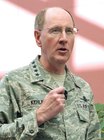
The four-star guest and evening banquet speaker at this year’s event was General William L. Shelton (USAF), the Commander of Air Force Space Command. As such General Shelton is officially responsible for organizing, equipping, training, and maintaining mission-ready space and cyberspace forces and capabilities for North American Aerospace Defense Command (NORAD), U.S. Strategic Command (USSTRATCOM), and other combatant commands around the globe. As the senior space warfighter, General Shelton oversees U.S. Air Force network operations; manages a global network of satellite command and control (C2), communications, missile warning, and space launch facilities; and is responsible for space system development and acquisition. He leads more than 46,000 space and cyber professionals, assigned to 88 locations worldwide and deployed to an additional 35 global locations. So you might say he possesses unparalleled qualifications to be the senior warfighter at this year’s warfare symposium.
You might even get the idea that General Shelton likes Colorado, since he began his Air Force career there in 1972 at the United States Air Force Academy (USAFA) and this is his forth assignment to Colorado since that time. But for our purposes in GPS World, one of his most telling Colorado assignments was from August 1990 to June 1992, when he served as the Commander of the 2nd Space Operations Squadron (the folks who fly and maintain the GPS constellation among other things) at Falcon (now Schriever) Air Force Base, Colorado. In fact when I have the opportunity to speak to the space operators at Schriever AFB these days, my old stomping grounds, I quickly remind them that where General Shelton is concerned, almost any topic you broach concerning space operations, especially GPS, he can truthfully say, “Been there…done that,” and he has not the T-shirt, but the stars to prove it.
General Shelton’s Vice Commander, Lt. General Michael Basla (USAF), a lifelong communicator, was also a speaker and attendee again this year. Indeed, Mike has been a regular at this seminal warfighter event since he arrived in Colorado Springs at Peterson AFB. General Basla really knows how to stir up a crowd and he did not disappoint. While both General’s Shelton and Basla had important things to say, it was more important for the warfighters to see them there in person. The presence of the nation’s two senior space warfighters at a symposium for warfighters meant a lot to these brave young men and women, and it showed. All week long I heard the warfighters talking about meeting and getting to hear General Shelton and General Basla speak. A few even hoped to be able to speak to them privately, and they were not disappointed.
General officers do not of course vie to win popularity contests, but if either General Shelton or General Basla were running for public office this year, and the warfighters had their say, the generals would win by a landslide after their presentations and their presence at Keystone.
General Jerome O’Malley Award
The General Jerome F. O’Malley Distinguished Space Leadership Award was awarded to Brigadier General David D. Thompson, the Director of Air, Space and Cyberspace Operations for Air Force Space Command. Mrs. Sharon O’Malley Berg was on hand to present the award and speak about her famous father who many credit for originating the idea of and laying the groundwork for Air Force Space Command.
Warfighter Panel
Nothing Earth-shattering came out of this year’s conference, and that’s probably a good thing, but the highlight had to be the warfighter panels. The young warfighters were exceptional this year; their stories were both heartwarming and heartrending. It is incredible the feats our young warfighters accomplish, whether they are in an F-16 Fighting Falcon or infiltrating Taliban positions as Special Operators on the ground, always in harm’s way. There are space and cyberspace warfighters supporting all the warfighter missions, as space operators in CONUS (Continental U.S.), in the
ater at command positions, and in theater with the Special Operators; heck, as many of us discovered many of them are the Special Operators. I could not have been prouder, and everyone else felt the same way, as was demonstrated by the thundering applause and standing ovation each panel received. If you have never been to one of these events you can justify it by the warfighting panels alone. It is something you will always remember — bravery has that effect.
Memorable
I attend a great many symposia and numerous conferences every year. Sometimes, unfortunately, the venues tend to blend together and you may not even know in what city you are located. However, few if any come close to the ambiance and connectedness of the warfighter symposium at Keystone. You will never mistake it for any other location. The facilities at the Keystone Hotel and Convention Center are first class, and the staff treat the warfighters with special care. More than one of the warfighter panel members, who had just arrived back home from theater, commented that he and his family (yes, the symposium sponsors paid for him to have his family with him) felt like they were in a five-star resort, and it was a much-needed vacation and time together with his family. Many of the warfighters also commented on the extraordinary level of service and the excellent cuisine. For that they have the fantastic magician Angela Andrews, the director of Conference Services and Catering, and her excellent staff at the Keystone Convention Center to thank. Angela and her staff oversee every detail and you do feel pampered. Another distinct advantage of a small but personal and service-oriented symposium in the Rocky Mountains. The cuisine is five-star quality and they have their own pastry chef, which is immediately evident the first morning you partake of the incredible breakfast pastries and treats. Don’t tell my wife, but I’m quite sure I had more than one every morning. It generates a genuine desire to have breakfast for lunch, and breakfast for dinner, if you catch my drift!
Now, I ask you, don’t our warfighters deserve this kind of treatment? From a dark, dank, dangerous, and stinking goat-infested cave in the mountains of Afghanistan, with enemies on every side, to the Keystone Hotel in the beautiful Rocky Mountains where everyone is your friend and supporter. Frankly, it doesn’t seem like too much to me; it just simply seems like the right thing to do. Join us next year won’t you? June 2012, and if you dare, bring your mountain bike.
Joint Navigation Conference (ION-JNC)
Actually, the real name of this conference is a mouthful: The Joint Services Data Exchange (JSDE) and The Institute of Navigation (ION) Annual Joint Navigation Conference (JNC) — or just JNC for short.
For our purposes, the difference between this conference or symposium and the previous warfighter symposium is that papers, presentations, and demonstrations are given by GPS, GIS, and GNSS experts from around the globe on our favorite topics, things to do with positioning, navigation, and timing (PNT).
There are numerous exhibits and an exhibit hall, which will suck you in and never let you go if you allow it to, but only because the exhibits are so interesting. There are of course plenary and general sessions, but basically everyone comes for the individual papers, the research, the camaraderie, the networking, the technical expertise, and the of course the warfighter panels. Indeed, the warfighter panels at this conference are held at the SECRET level each year in a secure location and are limited to citizens of the U.S., U.K., Australia, and Canada. This year the classified events were held in Colorado Springs at Fort Carson, Colorado, one of five military installations in the Colorado Springs area. More on the warfighter panels later.
JNC Venue
This year the JNC ran June 27-30 at the Crowne Plaza Hotel in the Springs, and as I said the classified sessions were held at a separate and secure location.
The accommodations at the Crowne Plaza were barely adequate this year because no one knew the conference would grow so much in popularity. But then when your conference is in demand, attendance will grow, and attendance at the classified sessions alone this year doubled from 300-600 attendees. So the normally unflappable Lisa Beaty that I know and respect at ION and her excellent staff were caught a bit off guard. People typically travel from all over the globe to attend JNC, and this year was no exception. As the numbers mounted, Lisa had a choice between restricting attendance and limiting papers or opening the gates and hoping for the best. The latter choice was the correct one, of course, and in the end it all worked out fine. Some sessions were standing room only and the hotel could not accommodate everyone, but there are numerous excellent hotels in the vicinity. There may have been room for a few more exhibits, but if it grows by as much next year the space may well be maxed out. Such is the price of popularity, and who knows? There may be some hidden space no one noticed. I am sure they will have it all sorted out by next year.
There were few senior officers present this year, although they have frequently been there in the past. But again this is more of a technical and warfighter exchange than it is a policy meeting. Frankly, the people that needed to be there were there, although a few more stars might increase the draw for some potential attendees. Sure, just what Lisa needs right now, a bigger draw! Stars or no stars, if you are a technical PNT geek, this is the conference/symposium for you.
While the presentations generally ran the gamut from good to great (we are generally speaking about engineers here after all), the information exchange and networking that went on were phenomenal to see. There are numerous subject-matter tracks to follow, and only you can decide where you need to be when, but fortunately there are plenty of readily identifiable JNC staff members around to help you find your way.
Presentations
As far as presentations go, the presenters have a stop-light system to help them stay within time limits and ION is ruthless about enforcing it. After all, why wait all day for your favorite presentations just to have them canceled because someone was long winded? This will never happen at JNC. Stars, bars, stripes, mister, or doctor — you have your allotted time for sound and fury on stage and then the hook. It is all very politely accomplished of course, and no one gets the bum rush, but that red light blinking in your face lets you know your allotted time has come to an end. I sincerely wish more conferences ran with this much precision and efficiency. Lisa and her staff are to be congratulated for their Teutonic punctiliousness.
FOUO
I wish I could relate more concerning the excellent FOUO papers; however, ever since 9/11, many JNC presentations have been conducted at the FOUO or For Official Use Only level. Frankly that means that, since this is an international magazine, I cannot relate details of the various presentations. I know some publications blithely ignore that restriction, at their own peril, but you won’t catch me making that mistake. For ION members the papers will be published online at the ION site, and of course you are always free to attend and hear them in person, which is what I hope you will do next year. The presentations are well worthwhile, take my word for it. You can of course peruse the agenda and paper topics at the ION website. When they are posted you should be able to download a cleared version of some of the papers. The papers cover the gamut from an excellent GPS constellation update by Lt. Col. Jennifer Grant (USAF), the current Commander of the 2nd Space Operations Squadron, to something as esoteric as Al
ternative Navigation Technologies (Natural Occurring Phenomena) chaired by my good friend and colleague James Doherty (Capt., USCG Retired) at the Institute for Defense Analysis. Jim is a former President of ION and former Commander of the United States Coast Guard (USCG) NAVCEN (Navigation Center), and for Jim the more esoteric the presentation the better. Jim was also the moderator and organizer of the excellent warfighter panel. He shared the panel duty this year with the immediate past ION President Mickel Miller.
JNC Warfighter Panel
While there is indeed something for everyone at JNC, again the highlight of the event was the final classified day, which included the warfighter panel. And since it was held at the SECRET level I can say almost nothing except that you should have been there. However, Jim Doherty did ask a question of the panel that relates directly to GPS — the question we have been asking of warfighters in this column for the last five years, “If you could have the perfect handheld GPS/communications device, what features would it have?” Not surprisingly, the answers have not changed. The consolidated answer was basically an iPhone-sized device with iPhone weight and battery life with embedded military (SAASM-enabled) PNT and communications capabilities with an Apple- or Garmin-like friendly operating system, and a color screen with maps and multiple grid coordinate systems displaying blue force tracked assets and networking capabilities. In other words, everything the current MUE (like the DAGR) does not do in an iPhone-sized device with an operating system someone could actually enjoy using. There were other specifics, of course, that I cannot go into in this venue. But there were no surprises. The warfighters’ needs have not changed and the DoD continues to not meet them. I thank Jim for asking the question.
In the end the warfighters were simply phenomenal, and there was again thunderous applause, and the only standing ovation of the day, and possibly for the whole conference. If you are reading this in GPS World magazine, then this is not a conference you can afford to miss. I hope to see you in Colorado Springs next June at JNC 2012.
The first time I ever heard of the Magnavox Research Laboratory in Torrance, California, was in 1966, as a young engineer working at Hughes Aircraft. We were building large (46-foot diameter) ground stations for the Defense Satellite Communications System (DSCS). Magnavox was supplying the secret anti-jam modems used in the terminals.
Because of this, I also learned a little about spread-spectrum pseudo-noise (PN), something quite esoteric at the time and not taught in engineering school. I noticed a widespread respect for Magnavox from my colleagues who referred to the company and its equipment as “Magicbox.”
Within a year I had transferred to the Hughes division responsible for developing satellites. We were working on a study known as 621B, for using satellites for positioning. Our teammate for the study was Magnavox. That team was responsible for the payload signal design, for which the team chose PN as the modulation to provide for multiple access, ranging, data transmission, and anti-jam.
Before long, my boss decided to leave Hughes and go work for Magnavox. He took two of his systems engineers with him. I was one of them.
In1968, the U.S. Air Force could not yet sell the 621B concept as an Advanced Development Program, so instead opted to experiment and prove that PN modulation could be used to accurately measure a half-mile of cable. Hughes bowed out since there wasn’t any satellite procurement in the offing. Magnavox and the other 621B contractor, TRW, each took on the challenge of measuring the cable.
Where Hughes had been 10-deep in Ph.D.s in every discipline, Magnavox was 10-deep in PN experts, which I believe at that time was the world’s majority. Thus it was natural for the Air Force to ask them to continue, and develop a receiver to be used in the next phase of 621B. An inverted range was set up with four PN transmitters, and an aircraft with the receiver and a bottom antenna flew over them. The aircraft’s position was determined using the PN range measurements and the known locations of the transmitters. The data from that receiver, called the MX450, was used to help justify the Department of Defense (DoD) decision to proceed into the Advanced Development Phase of GPS. Some of the people who contributed to this were named in Dr. Brad Parkinson’s recent articles on the origins of GPS. During that time I was working on the next generation of spread-spectrum modems for the DSCS.
Magnavox went on to develop these PN satcom modems for all three services, and thus was a natural choice to develop the first military GPS receivers (known as X and Y sets and the first Manpack), as well as the first C/A receiver, the Z set, and the very first spaceborne receiver called GPSPAC.
As soon as we completed the first Manpack, I approached Col. Paul Weber, the Joint Program Office Army Deputy Program Manger, and asked if he would pose with the Manpack on his back for a brochure we wanted to produce to show to potential Army and Marine Corps users. He agreed, dressed in his combat uniform, and went with our photographer into the wild woods of San Pedro (near the Port of Los Angeles) for the picture shown in the brochure.
Magnavox also developed the military GPS Engineering Models in competition with Rockwell Collins. Magnavox lost the production contract to Rockwell Collins a year after I left to join IEC, now known as L-3 Communications.
Magnavox also pioneered commercial GPS sets for use in the marine and survey markets. Today, you will still find many of the original GPS user equipment developers still at it as consultants and engineers at Raytheon, Navcom, Trimble, IEC, and others. Perhaps our most famous alumni is Dr. Min Kao, the “min” of Garmin.
Len Jaconbson
LEN JACOBSON is a consultant to the GPS industry and has served as an expert witness in many legal proceedings involving GPS. He is the author of the book GNSS Markets and Applications, published in 2007, and is a longstanding member of this magazine’s Editorial Advisory Board.
General C. Robert Kehler, Commander of the U.S. Air Force Space Command
Editor Don Jewell Talks with the Air Force General Heading Space Command: His Views, Use, and Plans for GPS
Defense editor Don Jewell is a retired Air Force officer who served for 30 years; many of his former peers and contemporaries are currently senior officers in today’s U.S. Air Force. Don sat down recently with General C. Robert Kehler, Commander of the U.S. Air Force Space Command, whom he has known and worked with for more than 20 years, to discuss GPS from the four-star point of view.
Don Jewell (DJ): General Kehler, thanks for taking the time to have this discussion today. I would like to keep this very informal, more of a conversation, like the days when you and I and Willie Shelton [now Lt. Gen. Shelton, USAF] sat around on your lanai, sharing a brew, telling war stories, and solving the world’s problems.
General Kehler (GK): Believe me, Don, there are days when I wish we were still doing that. I appreciate the opportunity to have a conversation with you.
DJ:Great. Sir, to get to the crux of the matter, as the senior warfighter for space, how do you see GPS in the future, and how does it contribute to the joint fight?
GK: Don, you know this, as may many of your readers at GPS World, but I don’t believe we can say it often enough: GPS is the primary source of position, navigation, and timing (PNT) information for the Department of Defense, and it will remain that way at least until the year 2030. This has been a remarkably successful program, supporting the joint warfighter in nearly every aspect of joint operations. How GPS supports joint operations, whether it’s the individual soldier, sailor, airman, Marine, or Coast Guardsman, who is on the ground or inflight or who happens to be in the dark in a mountainous region somewhere or in the flat expanse of the desert — it doesn’t much matter. GPS has been their constant companion now for many years. They have come to rely on GPS in ways that help them do their job better, and it allows them to perform missions that in the past they would not have been able to perform in this kind of a manner, with this kind of perfectness.
GPS is going to remain the foundation of the PNT strategy. And with the modernization effort that we have underway in GPS, we are going to make sure that it remains the world’s premier source of position, navigation, and timing information, and in particular that it remains woven through the fabric of the joint warfighting network.
DJ:This portends an excellent future for GPS, despite comments by the Air Force Chief of Staff and Gen. “Hoss” Cartwright, vice chairman of the Joint Chiefs of Staff, that we should move away from GPS. Do the Chief’s comments cause you any concern?
GK:They do not cause me any concern. We are committed to keeping GPS the gold standard. We have a commitment in that regard. I understand exactly what the Chief of Staff said and why. I will be happy to discuss that more.
DJ: We’ll table that for now, and get to it later if we have the time. I have often heard you say in your GPS update and status briefings that GPS is one of your good systems. Indeed, you have described it as one of the systems you don’t have to worry about too much, because it works. It would be interesting to ascertain how you know when you are doing a good job with GPS. How do you know it works? For example, do you receive comments, e-mails, or letters from warfighters?
GK: I think there are really two big ways that we know we are doing a good job with GPS. First of all, we measure our performance against the standard. What the users see, of course, is accuracy and satellite availability. Those have become our two primary standards. We make sure we are performing up to those standards. And in fact, as you know, we continually outperform those documented standards and the requirements that we have.
We also look, not only at the satellites, but at the ground command and control (C2) system and the ground support network. We make sure those elements are always up and running as well. From a numbers standpoint, from a “how well are we meeting the standards we have set for ourselves” standpoint, we exceed those standards. We exceed in terms of accuracy and availability, both the satellite system and the ground-supporting infrastructure as well.
But these days, I will tell you, I think the numbers are interesting, but what I think we look at just as hard is how the public talks about GPS.
And if you look today, GPS, at least in my opinion, is everywhere in the public conscience. I was saying earlier today, you really don’t have to go much farther than your television set. Almost any evening you turn the TV on you’ll hear something about GPS. You’ll either hear people who are equating their product to GPS, or you’ll hear in a television show someone mention GPS or their GPS device. And that is without it being a program about the satellites themselves, or the U.S. Air Force, or the things we do at Schriever Air Force Base to make it all work.
My view is that the fact that we get this informal public feedback constantly, and that it’s positive, says a lot about how good a job we are doing as well. When your program becomes a new word in the English language, I think that says something about success. Any more, if you say GPS to people they might not point to a satellite, they might point to the little device they are holding in their hand, but they understand somebody is providing that for them and that it is working well.
The final piece to that is also our civil partners. You know we have a GPS Executive Committee (PNT ExCom) inside the government that meets periodically to have conversations about the way ahead on GPS for the entire government, and by extension for the United States. The feedback that we get at those meetings, and unfortunately I can’t get to every one of them, but in those that I have attended, the feedback has been universally positive.
We just had a Civil Focus Day recently, and the feedback we got was universally positive. Are there things we can do better? Yes, of course there are, there are always things you can do better, but I can tell that we are doing a good job with GPS, not only because of the numbers that we look at but because of the feedback that we get, and the way GPS has been accepted and adopted, if you will, as part of the lexicon.
DJ: You’re absolutely right about the positive feedback. I attended Civil Focus Day, wearing a different hat, as you know, and I agree, everybody was onboard and positive about GPS.
The next topic revolves around how your scorecard is graded by the joint community, and do you have a way of actually getting feedback from the warfighter?
GK: Yes, as I said, we are graded or we grade ourselves primarily on accuracy and availability as they are documented for us in the performance standards. In watching those numbers, we know that we are exceeding the performance standards that we set for ourselves. But we also receive feedback directly from the warfighters. We receive feedback from the military users through the GPS Operations Center (GPSOC). You know, and I think most of your readers know, that there is a way that you can directly contact what we call the GPSOC 24 hours a day, seven days a week, and we find that both our military and civilian users do that.
Another way that we receive feedback is through the Coa
st Guard Navigation Center (NAVCEN), where they are specifically watching and helping us watch the performance of GPS. We get feedback directly from them as well. But much like the prior topic, there are also other ways that we get feedback.
For example, in each of our theaters of operations, for each of our combatant commanders, the joint or combined force air component commander is also designated as the space coordinating authority. And working for that space coordinating authority in the AOC (Air Operations Center) is someone called the director of space forces, an Air Force officer who is responsible for making sure that the space support is there when it needs to be and in the fashion that it needs to be. Those directors of space forces also have a small staff working with the combined force air component commanders.
They are getting direct feedback from the warfighters as well. They are either getting it as a normal course of business, on a day-in day-out basis, or they are asking for it specifically as well. We are also getting direct feedback from the units themselves. We have made contact through a number of our forward space people. We work with Army Space and Missile Defense Command and as a matter of fact we have talked with the Marines and others directly. We don’t wait for their feedback, we go out and solicit it also, and we actually help them solve some very difficult problems that we had early on in the conflict with some of our weapons systems that we have now fixed.
We are mindful, we know when certain operations are underway, we deconflict that with activities in the [GPS] constellation, making sure that we are providing the very best service all the time. We are embedded through the planning process in the theaters with military operations and with space professionals who are in the planning cells and Air Operations Centers. We are very comfortable. We are getting constant feedback from the warfighters in addition to the scoring we do ourselves and against the performance standards.
DJ: As you know, in many of my articles I frequently comment that where GPS is concerned, geometry and numbers matter. In that regard you recently approved a 24+3 GPS constellation change. Now we get a good many letters from warfighters at GPS World, and some letters are all about GPS accuracy as you spoke of earlier, but actually more letters mention GPS availability as being critical. Where do you stand on the debate of what is more critical, accuracy or availability, as far as the warfighters are concerned?
GK: We don’t separate the two children here, availability and accuracy. Obviously, it doesn’t mean a lot to us if you have high availability and not high accuracy, or if you have high accuracy and not high availability. They go together, and we work both of those issues. We try to make sure that we have the highest availability and accuracy. The accuracy numbers have been very good, as you know. We have been trying to improve availability, particularly for users in impeded environments. We are doing that by taking advantage of the largest constellation of operational GPS satellites we have ever had on orbit. We have begun to adjust the way we have configured the on-orbit constellation.
You called it 24+3, and we were all calling it 24+3 for a while. Now we are calling it Expandable 24, because those are the words that are actually in the Standard Positioning Service Performance Standard. We are expanding the available operational useful slots from 24 in the constellation to 27, and that movement is underway. This should result in improved availability for users in challenged areas like mountainous terrain, deep canyons, and in some cases urban terrain. It improves those kinds of availability numbers worldwide for everyone, for all users. This is not just for warfighters, it’s for all users.
We have begun the movement of the satellites (SVs), and because we are trying to balance on-orbit longevity with movement, it will take us a period of months to move the satellites to the new locations. That movement is underway, and the availability numbers should begin to improve as the movement begins; you don’t have to wait until they are all in their final locations.
By the way, as an aside, just last night, I was driving in Washington [D.C.] and I was using the navigation feature in my cell phone. One of the things it tells you is how many satellites are in view as you are driving along. Now, just to be clear, I was not driving, I was a passenger in the car, so I was not distracted by trying to drive. But I sat there with the thing in my lap, watching it while we were driving through the streets of Washington, D.C., and there were never less than nine satellites in view. At best I noticed that there were 12.
So I thought about that for a minute. Half of the constellation was occasionally in view as we were driving around the streets of Washington. This is pretty powerful, and we are talking about availability. I sat there thinking to myself, yo, if we can help somebody out there — turn that availability when they need it into the right number of satellites — this is a pretty powerful movement that we’ve got going.
DJ: It is, and what you just said about being in the back of the car reminds me about what General Chuck Horner (USAF, ret.) said after he retired as commander in chief, Space Command. He said you know you are truly retired as a four-star general when you go out and get in the back of the car in the morning, and nothing happens.
GK: You’re exactly right. I have a new officer aide who had never been stationed in Washington, and can’t survive in Washington without some kind of a GPS navigation device. He had one going in the front seat, and I had mine going in the backseat, and we were comparing notes as we drove along. It really is pretty remarkable.
DJ: Our readers will he happy to hear that you also have dueling GPSs. I have readers write and say they have up to three or four going at one time on long trips, comparing different GPS device accuracies and interfaces.
GPS has truly been a life-changing event for many of our users, especially the warfighters. I receive hundreds of letters and e-mails from warfighters and this move to Expandable 24 is meeting with unanimous approval.
GK: That’s good to know, and I must say that originated here. Actually, that originated with the IRT [GPS Independent Review Team], as you well know. We then took that to Strategic Command, and Strategic Command embraced it. General Chilton embraced it immediately, and I think that we have done the right thing here. The downside risk here did not outweigh the positive impact that we think we can have on people who need expanded availability.
DJ: Sir, as I said before, wearing a different hat, I attended your Civil Focus Day and I thought it was outstanding. Do you have any comments you would like to make concerning that event, and do you think you achieved your goals?
GK: We did achieve our goals, because our primary goal is improving communication and cooperation, as well as making sure we’ve got a stronger working relationship between the civil and military GPS communities. In that regard I think our goal was achieved. We addressed a lot of crucial concerns that impact both communities. We emphasized that the ongoing GPS modernization and enhancement efforts are going to be transparent to the civil users, and in fact will result in pretty dramatic improvements for civil users:more signals and other enhancements that I think are going to be useful as time goes by. In that regard I was very pleased.
We had a number of very senior people throughout the government who expressed their interest in GPS with their attendance. We had seen, as you know, additional commitment from some of the other [U.S.] government agencies to be supportive in helping to invest in GPS, which I think is very positive. I just think that in general terms we want to make ourselves more transparent in terms of how we are dealing with the constellation and the future of the constellation.
We recognize in Air Force Space Command the unique role that we have for this global utility that the United States of America provides free of charge for everyone else on planet Earth. We recognize that with the use of this and the increasing impact it has on all our lives, comes a unique responsibility for stewardship. We have embraced that responsibility, and that means we have to be transparent and we have to have a collaborative team that we work with, and that was a large part of the Civil Focus Day.
DJ: Many of the proposed systems that may or will one day compete with or complement the GPS are on hold, delayed, or still not at full operational capability. What is your viewpoint on where we stand in relationship to these systems, such as GLONASS, Galileo, and Beidou, for example?
GK: Our objective from an Air Force standpoint has been to support the U.S. government’s goal of wanting to engage in cooperative activities related to space-based PNT, and I think the focus of that cooperation has been to try and ensure that we have compatibility between GPS and other space-based PNT systems. There is a goal on our part to make sure we can be compatible and interoperable. There is a goal on our part to make sure we are protecting our national security interests and that we are maintaining a level playing field in the global market for space-based PNT goods and services.
Those are our objectives, those are the national objectives of the U.S., and the Air Force is supporting those objectives through our management and operation of the GPS constellation. That will continue to be our posture: to make sure, as best we can, to have fostered successful relationships on space-based PNT.
DJ: You certainly can’t ask for more than that. The objectives are laudable, but on the surface they don’t necessarily fit well with the recent comments by the chief of staff of the USAF, and I guess that brings us to the topic we briefly discussed earlier. Do you fully understand where the chief was going with his comments concerning GPS at Tufts University last month, and do you have any comments that might help our readers put the chief’s remarks in the proper perspective?
GK: I do. I was present when General Schwartz made his comments, and honestly I understood what he was saying and why. I think that he was misunderstood in implication. I think what he said was misapplied by some. In my view, General Schwartz fully supports GPS. What he was doing, though, is he was talking about GPS and its value for military operations.
What we know is that, like any other military capability that we rely on for important pieces of our warfighting force, GPS will be challenged by a determined enemy that is interested in trying to defeat U.S. forces on the field of battle somewhere. He was reminding us that we need to be mindful of that:adversaries could potentially exploit GPS as a vulnerability because of the way we have come to rely on our GPS for our own American way of warfare. And because it is such a critical system to the warfighter, it will be an attractive target to any would-be enemy.
Having said that, his point was, with which I fully agree, we have to be diligent in finding ways to operate with the same accuracy and precision in the event that GPS is degraded. That’s exactly what the GPS Modernization Program is designed to do. But this goes beyond GPS as well, it goes into other things, for example, missiles are guided to targets or munitions are guided to targets in some cases by GPS, in some cases by inertial systems, and in some cases by a combination of both. It would be foolish for us to not have provided for the eventuality where GPS will be jammed. But again he was talking about a military environment here; he was not talking about the global environment, he was talking about the military environment.
I recommend to people sometimes that they should go look at, well, pick your search engine of choice on your home computer, and type in “GPS jammers” and see what you get. There is a proliferation of GPS jammers around the world, everything from the sizes that will plug into the cigarette lighter in your car to large devices that are sold internationally for military purposes. We know that GPS will be contested when or if we are involved in any military conflict. The chief was warning us that we need to take that into account, and I believe he was exactly right to do it.
DJ: Thank you, sir, that helps clarify the Chief’s remarks considerably. I just wish he had said what you said versus what he said. Sometimes senior leaders are just too close to the problem and they erroneously assume their audience has information, knowledge, or insights that they in fact just do not possess, and it skews their perception of the senior leader’s remarks.
The last topic I would like to discuss concerns the infamous AEP 5.5C update that did not go quite as well as planned. Again in this instance, the public perception may be skewed by a lack of information and a lack of communication. I know you are fully up to speed on this issue; what are your thoughts?
GK: I would make a couple of points about upgrading the ground software. First, with this latest version of the ground software, AEP 5.5 and all of its iterations, we learned a lot about the complexity of the GPS system, how complex it has become. We learned a lot about standards, and what happens if you make receivers and you don’t follow the standards, because there was nothing wrong with the [AEP] 5.5 software in this case. The issue was in the receivers — a very small percentage of our military receivers — where the manufacturers did not comply with the standards. We hold ourselves to a set of standards, we publish those standards, as you well know, and it is important for people who are making GPS devices to follow those standards.
Now here’s what we learned, though. We learned that not only is it important to follow the standards, but we learned that we can do better in how extensively we test prior to installing software. By that I mean — not that we didn’t test extensively before — increase the population of receivers that we test against and the rigor with which we test them, would be a better way to say this.
The other thing we learned is that collaboration and cooperation needs to be more robust, such that we are doing these upgrades on an active basis, not a passive basis. What we had been doing before is we would publish a NANU and say that we were about to do an upgrade to the ground software. We would then do the upgrade. We would wait to find out what was happening. What we learned this time was, that is probably too passive as we go to the future. Not only will we test more extensively across a broader range of GPS devices, but we will also put [receivers] in place, in a series of predetermined locations, if you will, where we will contact them actively to find out as we are progressing whether they are encountering any difficulties. We did learn a lot here.
We also learned that these upgrades need to be done in a fashion that is repeatable, so that every time we do this we will have a process in place that allows us to treat them roughly the same, depending on the magnitude and risk associated with the change, if you will, in terms of how we intend to go forward. I think we learned a lot about vetting and we learned a lot about execution. We
reminded ourselves again why standards are so important, and we reminded ourselves why partnerships are so important and why rapid feedback is important: so that we can deal with problems as they emerge.
We also learned something for the longer term, Don. We learned that we probably need better simulation tools as we look to the future, because you know there is only one active system, and it is the active system. It has become so complicated that there are hundreds of millions of receivers out there, as you well know, and the likelihood that we can characterize all of them in advance of a software drop is pretty low. We are going to have to get better at following a simulation as we go forward.
The most significant piece of data, though, from all this was there was nothing wrong with AEP 5.5. It performed exactly the way it was designed. The issues that were encountered were anomalies in user equipment, and that user equipment was identified because it did not follow the standards.
DJ: General Kehler, do you have any closing remarks for our readers, a message you want to make sure gets heard?
GK: Don, we understand the unique position that we are in as stewards of GPS. This is unusual, I believe, throughout the U.S. military, that a military service would have this type of responsibility for a system that has this kind of global impact. And it has that global impact 24 hours a day, seven days a week, 365 days a year. We recognize that unique responsibility that we have.
We know that means we have to be transparent about the way we conduct our business. We think that we are doing much better at that, and we will get better at that even more as we look to the future.
Our bottom line is that we believe that GPS is the gold standard today for the world. We intend to keep it that way as we look to the future, and we will allow the performance of the GPS system to speak for itself. We are very, very proud of the job that we do regarding GPS.
The young — many very young — men and women who operate and fly that constellation everyday, the outstanding technical people we have who design and build the satellites, the phenomenal launch team that we have that gets them to the Cape and gets them successfully on orbit — all of these pieces that are taken together along with, by the way, a civil group of participants from across the government who work very hard at all of this, along with independent folks who are on our review teams and elsewhere as well as the industry, the broader industry —this is a remarkable success story that has now influenced virtually everything we do, everywhere on the face of the planet. I think we ought to be very proud of that, and I can tell you that this Command is extraordinarily proud of it and recognizes that this puts a unique burden on us to deliver. We are going to continue to do just that.
DJ: That’s a great message and a very important one. In closing, might I ask you about your future? Rumor has it that there are plans afoot for you to move onward and upward.
GK: Don, my wife keeps saying that we go to Myrna — she is the dry cleaner and tailor down the street here — to find out where we are going.
I don’t know. I have been here two and a half years, Don, and typically this assignment will last about three years. That will take us into late summer, early fall, and I honestly, honestly do not know what happens with us next. We are going to have to wait and see what the pleasure is of my superiors and how all the pieces sort of fit together.
I think you know, when you get to be a four-star, there are a lot of factors that come to bear. At this point we will just have to wait and see. The only thing that I am worried about right now is the job that I’ve got, and I will be very, very pleased to stay here. We could stay here for 10 more years, and I would be delighted to stay here because this is a magnificent command.
We are doing phenomenally important work, and I am very proud of the people in Air Force Space Command. This is a wonderful, wonderful group of people.
DJ: You should be proud of them, sir. We get a lot of mail about what a great job the Air Force is doing as the steward of GPS. Our mail is always very positive concerning Air Force Space Command. I want you to know, sir, in closing, that working with Colonel Ford and Colonel Buckman has been a real pleasure. Your folks have been just super.
GK: I think so, too, and I don’t tell them that enough, really. We’ve got a great team here at headquarters, and we’ve got a great team across this command. We are delighted to have cyber responsibilities now, and there is clearly a relationship between space and cyberspace, and we see it. Every time I get a chance to commend the people in the Command, I like to take the opportunity to do so.
DJ: Thank you for your time today, sir. I know how busy you are, and I think we should find the time soon to sit down and have another discussion, possibly on cyberspace.
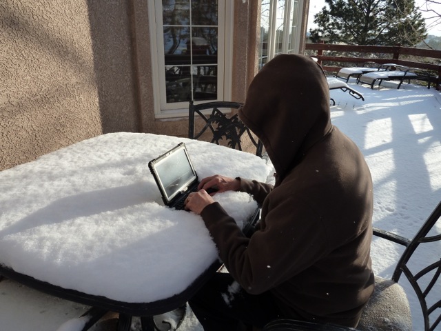
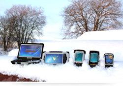
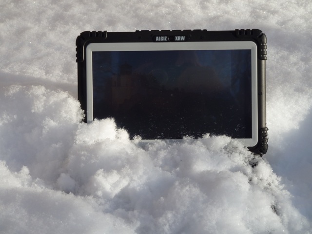
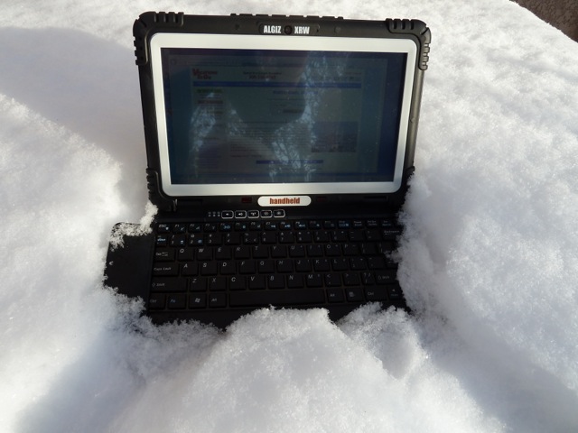
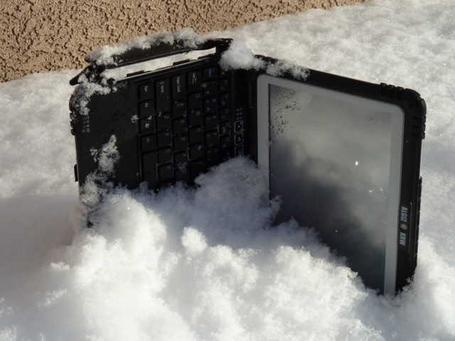


 Nation’s Senior Space Warfighters