General Dynamics Mission Systems has introduced its HOOK3 combat survival radio.
The HOOK3 radio is 30 percent smaller and 40 percent lighter than the HOOK2 radio, and has a smaller, longer lasting battery, the company said.
In addition, the embedded GPS module has 32 channels enabling a faster position acquisition time, more accurate position reporting and better performance under forested or densely vegetated areas or near structures.
The radio transmits encrypted GPS, user identification, situation reports and other critical information to rescue teams and aircraft in short bursts to reduce the risk of detection. The radio can also use multiple GNSS.
The new radio provides direct line-of-sight voice and encrypted two-way data communications to help combat search and rescue teams quickly and accurately locate and rescue downed pilots and isolated military personnel, the company added.
The HOOK3 was designed using feedback from military personnel who rely on a survival radio in emergency situations. The new radio automatically activates and securely transmits location data when specific G-Force or the presence of salt water is detected by the radio.
“General Dynamics has delivered more than 36,000 combat search and rescue radios to 36 countries over the past 30 years,” said Paul Parent, a vice president of General Dynamics Mission Systems. “These radios have helped save the lives of military personnel isolated or in harm’s way during a mission.”
“The HOOK3 provides military personnel in emergency situations a highly reliable, easy-to-use, secure radio critical to their successful recovery.”
The General Dynamics HOOK3 radio is interoperable with all HOOK2 family radios, Quickdraw2 and SATCOM base stations currently used by U.S. and international military personnel.
The HOOK3 is designed for coalition operations, and the user-friendly transceiver is software-defined, enabling new features, waveforms and software upgrades to be added as they become available.
I have mixed emotions as I write this column. Delighted, absolutely, to be given the opportunity to write for GPS World on topics that I am so passionate about; but also sad that we will not see any more articles from Don Jewell, whose excellent columns I followed so religiously over the years. I never had the opportunity to meet Don personally but, to me, he is irreplaceable. But let’s talk about the changing face of defense positioning, navigation and timing (PNT) — not in the editorial sense, but in the technology sense.
As we all know, PNT and GPS are no longer synonymous. With a host of innovative technologies on the horizon, PNT is about so much more than GPS these days, and the military knows it. Sure, GPS has been the workhorse of PNT for many years, and it’s not going anywhere anytime soon. I’ll be clear on that: GPS is not going anywhere. But it’s not a complete solution either.
Let me paraphrase what a friend in the infantry tells me, by saying GPS is a 60 percent solution to their navigation needs. What does that mean? Well, it goes something like this:
60 percent of the time: GPS is great, it does what we need.
20 percent of the time: We are indoors or underground, and GPS is simply not available.
15 percent of the time: We’re in an urban canyon. GPS availability is intermittent, and the accuracy is poor.
4 percent of the time: We’re in forests or dense vegetation, and GPS is sporadic.
1 percent of the time: GPS is jammed.
You can argue the numbers depending on the mission, but you get the idea. What, then, is the answer for the soldier? Well, first things first: We don’t want to reinvent the good 60 percent so, once again, GPS is here to stay. The question is how do we push past that 60 percent figure and get ourselves closer to 100 percent? Let’s go from the bottom up, and address GPS jamming.
Overcoming interference
The classic solution to jamming is an adaptive antenna, also known as a controlled radiation pattern antenna (CRPA). More on this another time but, for now, suffice it to say that CRPAs are a well-understood and mature technology, and can offer very high levels of jamming resistance.
The often-cited disadvantage of a CRPA antenna is its size, weight and power: As CRPAs employ multiple antenna elements, they are inherently larger and heavier. The electronics can pretty much be covered by a single chip these days, leaving the antennas themselves as the problematic aspect, but advances in antenna technology have also made big hurdles.
For airborne platforms, conformal antennas designed as part of the structure or fuselage can be used; whilst for the dismounted soldier, the trend is towards wearables, where the antennas may be an inherent part of the clothing or helmet design.
Aside from adaptive antennas there are a whole host of other techniques in your anti-jam kit bag, including receiver-based techniques.
It’s a numbers game
For forests and urban canyons, this is where multi-frequency multi-GNSS comes into its own. It really is a numbers game: The more constellations you use, the more satellites you can choose from, and the greater your chances of seeing enough satellites to derive a reasonable navigation solution. You also have more options for mitigating the effects of multipath and other errors.
Of course, this gives rise to a potentially difficult question for some governments: In defense applications, do you want to rely on foreign GNSS constellations as part of your PNT solution? The attitude here depends on your own country’s policy and a trade-off of perceived gains against perceived threats. The UK, for example, has chosen to embrace all available constellations and frequencies in future military navigation systems.
That’s probably about as far as GNSS gets you, because now we’re looking at the 20 percent of the time where the user is indoors or underground. In other words, environments where GNSS simply isn’t available. This 20 percent is perhaps more tricky to address, and is the realm of alternative and complementary PNT technologies.
Beyond GNSS
Fusing different sensor modalities to create a combined navigation solution is anything but a new idea. The benefits of combining GPS with an inertial sensor were recognized a long time ago, and this classic pairing continues to be the subject of research today.
The two technologies are highly complementary in various ways: GNSS offers absolute position, low short-term accuracy, and high long-term accuracy. On the other hand, an inertial sensor offers the opposite: relative position, high short-term accuracy, and low long-term accuracy. It’s a match made in heaven.
But whilst GNSS plus inertial may be a good choice for, say, airborne platforms, it doesn’t solve the in-building and underground problem. Without GNSS, you need something else.
Indoor navigation has been one of the hottest research topics of recent times, but there are really two types of indoor scenario: the first is when you’re in a shopping mall or airport. You can use an inertial sensor, Wi-Fi, mobile base stations, and various other bits of infrastructure to help you navigate.
The second scenario is the military one: You’re in an unfamiliar enemy compound or underground tunnel complex. In this case, there is no GNSS, no Wi-Fi, no mobile communications; and, for navigation, you can only really rely on the sensors you bring with you.
So what other sensor works underground, and complements inertial?
Visual/inertial integration
Visual odometry is an established, yet often overlooked, navigation technology that is undergoing a resurgence of interest, in both military and civilian applications. In simple terms, visual odometry uses sequential camera images to determine motion in a six degrees of freedom reference frame. Using either single or multiple cameras a platform can estimate both its 3D position and orientation, providing much the same information as an inertial sensor — but with a few added benefits.
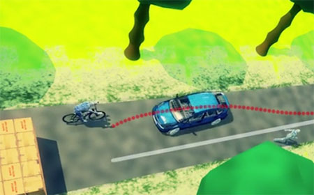
Visual/inertial sensing allows 3D reconstruction of a road incident. (Screenshot: Roke)
Because cameras and associated vision-processing algorithms are capable of detecting corners and features, a 3D model of the environment in which the soldier is operating can also be built up. In other words, we can perform simultaneous localization and mapping (SLAM).
But like any navigation technology, visual odometry has its limitations. It likes well-defined features in the environment, such as corners, but can get confused by moving objects like trees and clouds. Its performance also depends on factors such as the quality of the camera and lens, and how well the system is calibrated. Like an inertial sensor, it provides a relative positioning solution and is subject to accumulation of errors over time. It’s a great technique, but it really comes into its own when combined with another navigation sensor, such as an inertial unit.
And it’s not just the military guys who are taking advantage of visual/inertial integration. Just take a look at Google’s Tango project, or what Qualcomm is doing, or Roke’s black box for driverless cars, to name but a few examples.
Bringing it all together
Over the course of the last decade or two, the operational landscape for soldiers has changed significantly, with far greater focus on urban warfare. The military realized some years ago that the answer to robust navigation for dismounted soldiers was going to require a range of sensor modalities: no single navigation technology is ideal in all environments. That’s why this has been the focus of so many defense programs of recent years.
By way of example, the UK Ministry of Defence (MoD) initiated a research program in 2013 called Dismounted Close Combat Sensors (DCCS). The contract addressed a range of soldier capabilities, one of which was the ability to provide reliable soldier position and orientation in all environments.
The DCCS programme evaluated a whole bunch of technologies, but eventually converged to an integration of three primary sensors: multi-constellation GNSS, a low-cost inertial measurement unit (IMU) and a video camera. The single monocular video camera was used to strap down the IMU, in a very tightly-coupled system. It makes sense: when GNSS is available, use it. When GNSS isn’t available, the integrated visual/inertial navigation sensor continues to provide both location and orientation for the duration of the mission. As it should be for a tightly integrated navigation system, the performance of the combined system outperforms any individual sensor in isolation.
Whilst integrated sensor systems enable our soldiers to position, orientate and navigate themselves, the performance of individual sensors continues to be pushed to new limits. Inertial technology is advancing all the time, and defense is again pushing the boundaries. Take a look at what DARPA is up to, as an example.
The missing ‘T’
Haven’t we missed something? Ah yes, there’s a “T” in PNT. So whilst there would seem to be various options for achieving a robust positioning and navigation solution, we mustn’t forget precise timing for those applications that need it. Quantum technology is flavor of the month here and, once more, the defense agencies are furthering developments: DARPA with its ACES program, and MOD/DSTL via the Quantum Technology Program, to illustrate just a couple of examples.
So whilst GPS will continue to remain the workhorse, defense PNT is migrating from GPS-only to being a many-faced beast. And I haven’t even gotten started on pseudolites, signals of opportunity, eLoran, and cooperative navigation.
The future of defense PNT looks pretty good to me.
Two important new signals — or rather, one signal and one group of signals — became available for military users worldwide last week. Satelles made an exciting announcement of what amounts to a new dimension in satnav: a whole new constellation in low-Earth orbit, bringing global coverage and most critically, a signal strength hitherto unknown to GNSS users. The satellite time and location (STL) has primary application in the timing realm, which is vital in many applications.
Higher in the sky, Europe’s GNSS satellites constituting the Galileo system officially began offering their services, and the multiple frequencies available here mean robustness, greater availability in obstructed environments, and — some say, though this is controversial — greater positioning accuracy, largely through more precise timing onboard.
Meanwhile, GPS World seeks a new defense editor for this column, and adopting the concept of “promoting from within,” now turns to its readership for interested parties to volunteer.
A New SatNav That’s Not GNSS
A strategic alliance announced on Dec. 15 between companies Orolia and Satelles includes will provide positioning, navigation and timing (PNT) solutions provided by the Iridium satellite constellation, independent of GPS/GNSS signals. The companies intend to provide PNT solutions to military, defense, government and commercial customers worldwide. Their new satellite timing and location (STL) service can supply much-needed robustness to GPS-dependent operations.
Orolia, the parent of GNSS-active companies Spectracomm, McMurdo, and Spectratime, has extensive experience in the defense realm. The company says it is #1 worldwide in the manufacture of military beacons outside the U.S. with a 60% market share, and #2 within the U.S., and that it is the first-ranked provider of Medium-altitude Earth Orbit Search and Rescue system (MEOSAR) worldwide. In partnership with Satelles, it will provide the STL service independent from traditional GPS and other GNSS satellite signals. STL is reported to be less susceptible to vulnerabilities such as spoofing, interference and jamming that are associated with GPS/GNSS — and the stronger signal penetrates buildings where GPS/GNSS cannot reach.
Iridium satellite, courtesy Iridium.
Based on the low-Earth orbit (LEO) Iridium satellite constellation, STL signals are up to 1,000 times stronger than GPS/GNSS; this signal strength, due in part to the constellation’s closer proximity to users, helps to prevent jamming and enables signal reach into buildings and other difficult locations. STL’s additional cryptographic security also enhances performance, productivity and security.
Projected key applications and use cases include energy/utility grids, enterprise data networks including financial systems, maritime/aviation navigation, fleet/asset tracking management, search and rescue and data center management.
“The timing signal is very accurate and close enough to GPS for most timing applications, although the positioning accuracy is lower than what GPS users are used to,” said Orolia CTO Jean-Yves Courtois. “It is an augmentation for timing primarily, and secondarily for positioning.”
“In terms of timing accuracy, it provides on the order of tenths of microseconds in accuracy, and this covers a lot of timing applications, very familiar to us and to our customers. This is an ideal timing backup or augmentation of GPS. As number 2 worldwide in high-precision timing, we know this market and its applications very well.”
“In positioning it’s closer to fifty meters or more. Much better for fixed objects than for mobile objects. The more mobile, the faster the vehicle, then the lower the positioning accuracy. It’s not directly usable for GPS applications that require a few meters accuracy, but it can be associated with inertial navigation for much better results.”
“The signal is encrypted, so you have to subscribe to a service to receive a key, allowing access to the signal. Applications are developing based on equipment that will be STL-enabled. For the user it will be transparent. The user will have a different antenna.”
“We are also active in tracking and emergency location devices, where this is also of interest. It has some authentication capability, to guarantee that the person who accesses the signal is in the location that he pretends to be.”
Galileo, live at last!
Also on Dec. 15, the European Commission issued the Galileo Initial Services Declaration. The Declaration of Initial Services means that the Galileo satellites and ground infrastructure are now operationally ready. These signals will be highly accurate but not available all the time, since the constellation is not yet complete and users cannot always count on four satellites being visible at one time at all points on the Earth.
Galileo has a significant role to play in military operations. It adds multiple frequencies to the GNSS palette, important for resistance to jamming. It adds satellites, and will add more in the new future, very important for signal availability. And its Public Regulated Service (PRS) is specifically designed with special features for security, defense and military operations.
I attended a GNSS Symposium recently in Australia where an academic expert repeated the oft-made assertion that Galileo is the only GNSS that is civil-designed and civil-controlled. At which point an industry expert leaned over, grabbed the microphone and growled “Yeah, right.”
No matter how you look at it, Galileo add important benefits to GPS for the suitably equipped warfighter.
This Newsletter Enters a New Era
Beginning in January 2017, this Defense PNT newsletter will combine with our GeoIntelligence Insider e-newsletter to offer broad coverage of both hardware and software matters, driven by GPS/GNSS, and enhancing the capabilities of security, defense, military and other government forces. Readers of both newsletters will receive the new combined edition as a matter of course.
Many readers will know of the recent passing of Don Jewell, the longtime editor of Defense PNT. We must soldier on, and GPS World hereby extends an invitation to readers of this newsletter — many of whom, we know, are military experts in your own right — who may wish to volunteer to fill Don’s position. Please write to [email protected] to request details, and please provide a brief outline of your background and experience.
A networked radio from Thales is designed to meet soldiers’ need for assured positioning, navigation and timing (PNT) while on foot.
The MBITR2 is part of a broader defense effort to provide PNT solutions in case of GPS jamming or interference. The MBITR2 is one of a number of devices and technologies, many still in development, to address this need.
For instance, under a Small Business Innovation Research (SBIR) contract with the Air Force Research Laboratory, Navsys Corporation is testing a network-assisted PNT acquisition algorithm to run on tactical radios such as the MBITR2. The algorithm is designed to provide improved acquisition performance in a GPS jammed environment by leveraging an innovative assisted GPS (A-GPS) architecture where navigation and timing data are shared across the tactical radio network.
The AN/PRC-148B MBITR2 ground tactical handheld radio is small, light and power-efficient. It builds on the legacies of both the earlier narrowband AN/PRC-148 MBITR tactical handheld radio and the wideband AN/PRC-154 tactical handheld radio. It covers the 30–512 MHz frequency range.
When equipped with the MBITR2, dismounted warfighters can connect with the wideband tactical Internet protocol and the voice network via the Soldier Radio Waveform wideband channel, while maintaining contact via the legacy narrowband channel.
The MBITR2 is interoperable with MBITR radios already deployed. More than 200,000 are now in the field, and Thales said the earlier generation radios can be upgraded with a low-risk and cost-effective approach.
Further, the MBITR2 retains compatibility with the existing installed base of ancillaries.
MBITR2 features
Two radios in one
Simultaneous two-channel (narrowband and wideband) operations
Adds a second wideband channel to the AN/PRC-148 to provide networking, data, and video capability
Retains the existing AN/PRC-148 JEM Type-1 capabilities and waveforms
Insitu has been awarded a US$71 million follow-on contract to produce six RQ-21A Blackjack unmanned aerial systems (UAS), with options for two more, from U.S. Navy Naval Air Systems Command (NAVAIR).
The RQ-21A is recovered with the flight recovery apparatus cable aboard the San Antonio-class amphibious transport dock USS Mesa Verde after its first flight at sea. The tests were held in the Gulf of Mexico on Feb. 10, 2013.
The RQ-21A Blackjack has significantly larger payload mass, volume and power than other small UAS currently being used in theater, according to Insitu, a subsidiary of The Boeing Company. The system includes electro-optic and mid-wave infrared sensors with a laser rangefinder and infrared marker.
The Low Rate Initial Production (LRIP) Lot V contract also includes an option year for nine Full Rate Production (FRP) systems. The FRP decision review is expected this fall.
“This contract award paves the road for Blackjack’s continued and future fleet integration,” said Col. Eldon Metzger, program manager for the Navy and Marine Corps Small Tactical Unmanned Aircraft Systems Program Office. “It is at the tactical edge for Marine and Navy units and the foundation to support future system enhancements.”
“Blackjack delivers an organic intelligence, surveillance and reconnaissance UAS that is runway-independent and founded on an open architecture that allows for implementation of innovative payloads to meet critical operational demands,” said Ryan M. Hartman, Insitu’s president and CEO. “We are proud to provide the sailors and marines with reliable, capable systems that support their warfighting needs.”
NAVAIR awarded the STUAS Engineering Manufacturing Development contract to Insitu in 2010 to begin the development of RQ-21A Blackjack, a variant of the company’s Integrator unmanned system. The program achieved Milestone C in 2013, delivered the first LRIP system in 2014, and achieved initial operational capability in January.
Abstracts must be received by Feb. 15 and must be written for public release. For more information and instructions on submitting an abstract, visit the ION website.
The JNC is the largest U.S. military positioning, navigation and timing (PNT) conference of the year with joint service and government participation. For Official Use Only (FUOU) U.S. ONLY sessions will be held June 6-9 at the Dayton Convention Center in Dayton, Ohio. The U.S. ONLY CLASSIFIED sessions will be held June 9 at the Air Force Institute of Technology.
The ION Joint Navigation Conference, sponsored by the ION’s Military Division, will focus on technical advances in guidance, navigation and control (GN&C) with emphasis on joint development, test and support of affordable GN&C systems, logistics and integration.
From an operational perspective, the conference will also focus on advances in battlefield applications of GPS; critical strengths or weaknesses of fielded navigation devices; warfighter PNT requirements and solutions; and navigation warfare.
The ION JNC features more than 200 operational presentations on a diverse array of topics. It also features a technical exhibit and showcase of GNC technology products and services and operational product demonstrations.
Attendance Restricted. Conference attendance for both FOUO U.S. ONLY (June 6-8) and U.S. ONLY Secret Clearance (June 9) sessions will be screened by the Joint Navigation Warfare Center and will be restricted to U.S. ONLY.
AeroVironment has received an order valued at $13 million for RQ-20A Puma AE small unmanned aircraft systems (UAS) and initial spares packages for the United States Marine Corps.
The Marine Corps employs the Puma AE system as the long-range solution for its small unit remote scouting system (SURSS), complementing the AeroVironment RQ-11B Raven and RQ-12A Wasp AE UAS.
The Puma AE unmanned aircraft system delivers situational awareness directly to its operator in ground, to help provide information superiority on the battlefield.
AeroVironment received the order from ADS Inc. on behalf of the U.S. Marine Corps through the Defense Logistics Agency Tailored Logistics Support program. Delivery is scheduled within 12 months.
The Puma AE weighs 13.5 pounds, operates for more than 210 minutes at a range of up to 15 kilometers, and delivers live, streaming color and infrared video as well as laser illumination from its pan-tilt-zoom Mantis i23 AE gimbaled payload.
Launched by hand and capable of landing on the ground or in fresh or salt water, the Puma AE provides portability and flexibility for infantry, littoral or maritime reconnaissance operations.
Wearable fitness trackers such as FitBit could help military patients recover quicker, according to Col. Deydre Teyhen, an official with from the Defense Health Headquarter’s Office of the Surgeon General. The trackers could help patients with musculoskeletal conditions gauge how much physical activity they can handle without exacerbating their injuries, Teyhen told an audience at a conference hosted by tech association, AFCEA and reported by NextGov.
Device-agnostic software is needed to allow soldiers to use the devices they already own, she said. “The question becomes, is it a one-size-fits-all solution?”
For instance, some patients begin to feel better before their soft tissue heals fully, and start walking around more, which could inhibit their recovery process, she explained. An effective system might send that patient a notification on their fitness tracker to say, “‘You’ve done great, at 1,000 to 2,000 steps a day,’ and it gives you a warning … ‘You might actually be doing too much and you might cause a setback.’ If you give them that warning in real time, then they can change their behaviors.”
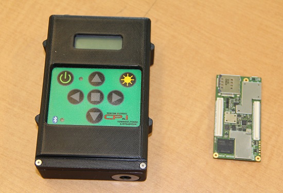
The current WINS form factor (left) sits beside a prototype for the future incarnation.
The Evolution of the Warfighter Integrated Navigation System
A new device is being developed to enable foot soldiers to find their exact location in GPS-denied situations. If satellite signals are blocked by heavy jungle canopy, or because of enemy interference, soldiers — and Headquarters — will still know where they are with the Warfighter Integrated Navigation System (WINS).
WINS will be a compact, wearable navigation device capable of operating either as a standalone system or networked to distribute position location information to other soldier platforms. WINS will extend positioning capability for soldiers in environments where GPS is not available, reducing the effect of GPS interference and enabling integrity monitoring for trusted position reporting.
The technology behind WINS is being developed at the U.S. Army’s Communications Electronics Research Development and Engineering Center (CERDEC) labs. “WINS will be not just one technology; it’s a soldier-worn multi-sensor source incorporating information from GPS, inertials, vision-aided navigation, RF ranging, etc.,” explained John DelColliano, chief for CERDEC’s PNT Branch, which falls under CERDEC’s Command, Power and Integration Directorate (CP&I).
“All these will tie in to making a more robust navigation system, so if you’re in a situation where GPS fails, you can have other things to back you up.” For instance, inertial sensors will calculate an offset from the last-known GPS location using footsteps taken, speed, acceleration and time.
“The bottom line is that the soldier, without having to do any extra work on his own, will have a navigation system on his person that will provide him with a solution that he can count on when he needs it,” DelColliano said.
WINS is expected to help eliminate dependence on vulnerable commercial receivers. It will improve positioning in GPS-degraded environments, enduring some jamming and providing positioning indoors and in urban areas. It will enable soldier-based cooperative engagements and provide trusted dismounted soldier position through integration with Selective Availability Anti-Spoofing Module (SAASM) GPS receivers and redundant navigation sensors.
“CP&I’s PNT branch has worked on these individual technologies for many years, but we’ve always had the vision of an integrated solution,” DelColliano said. “That’s where we are today. It makes the most sense for what the soldier is going to need in the battlefield.” With a WINS-equipped solder, DelColliano said, “We’ll be able to know where he is and at what time, and we’ll be able to track if something happened to him. This capability will also enable our forces to be more mobile and maneuverable. It allows the commander and HQ to see where each squad is.”
As part of a technology demonstration program at Fort Dix, N.J., WINS is being developed under an incremental build process as researchers consider what functionality should be incorporated. The engineering specifications for WINS are expected to be transferred to Program Executive Office, Intelligence and Electronic Warfare & Sensors by 2017, and from there eventually be made available to soldiers.
Future WINS capabilities
The final version of the WINS will have the following capabilities:
Military GPS for a protected signal and anti-jam capability on the soldier.
Inertial measurement unit for soldiers to track their location.
RF ranging using a radio or radio-like device to communicate between soldier-worn nodes and determine the range between soldiers, computing positions through triangulation relative to GPS.
Vision-aided navigation using the same kind of camera as in a cell phone, which is ideal for SWaP-C (size, weight and power compliance), to help navigate by tracking the soldier’s motion through an environment.
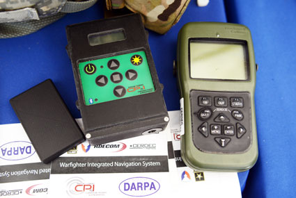
The Warfighter Integrated Navigation System, center, uses inertial systems to determine a Soldier’s location in the absence of a GPS signal. On the left, a smaller version of WINS. On the right, the Defense Advanced GPS Receiver, which soldiers use now for position, navigation, and timing. All three devices were on display at the DOD Lab Day, May 14, at the Pentagon. (Photo: U.S. Army/C. Todd Lopez)
When GPS satellites can’t be seen due to dense jungle canopy, or they are blocked due to enemy interference, soldiers will still be able to track their location digitally using the Warfighter Integrated Navigation System (WINS), a device now under development at the Communications Electronics Research Development and Engineering Center (CERDEC).
During the U.S. Department of Defense Lab Day held May 14 at the Pentagon, CERDEC researcher Osie A. David explained how the technology behind WINS will one day be transitioned to an Army program manager to bring assured navigational capability to soldiers.
The WINS is a device small enough to carry in a soldier’s cargo pocket, about half the size of a pack of cigarettes.
“It’s got a number of inertial sensors, such as a pedometer and an accelerometer, things you will find on your cell phone but of a higher quality,” he said. “Even if the enemy is denying you GPS or the terrain is, you can still get known location on here so it will show up on your Nett Warrior device or your command and control system.” The Nett Warrior is an integrated dismounted situational awareness and mission command system for use by leaders during combat operations, using advanced navigation and information sharing capabilities to allow for faster and more accurate decisions during the tactical fight.
The Nett Warrior
Those inertial sensors will calculate an offset from the last-known location using footsteps taken, speed, acceleration and time, for instance. The device even has way to measure altitude. “It’s got a pressure reader so it knows if you are on the third floor or first floor of a building,” David said.
The WINS isn’t perfect. As time goes by without a new GPS signal, its estimate of current location will degrade. But the device provides for the user an estimate of its own miscalculation. “After a time, it’ll show you a circle radius for the error range,” he said. “It’s still better than having no GPS at all.”
David said knowing location is everything in combat, and the WINS, or a follow-on system that uses technology from WINS, will make sure that soldiers have that no matter what happens to GPS.
“Say we go to Southeast Asia and I’m in the middle of the jungle. There are not a lot of good landmarks. I’m navigating around and I lose the GPS because with the triple-canopy jungle, the GPS can’t penetrate that. I don’t know where I am on the map, so I’m in a bad situation. If I want to know exactly where I am so I can call for reinforcements or resupply, WINS is going to give me my location on a map, no matter where I am.”
David said CERDEC is still working on issues like where soldiers should wear the device. He also said that he expects the engineering specifications for WINS to be transferred to Program Executive Office, Intelligence and Electronic Warfare & Sensors by 2017. It will be inside an Army program manager’s office, not an Army lab, that WINS or the technology it contains will be made available to soldiers.
The Soldier Power Manager sits on top of a conformal battery. Allowing multiple devices to be connected to a battery, it reports battery usage, power remaining, and power usage by connected devices. (Photo: U.S. Army/C. Todd Lopez)
David also had with him a device he called the Soldier Power Manager. The power manager was connected to a “conformal battery,” which was also developed at CERDEC in conjunction with industry. The conformal battery is flexible and slips easily into a soldier’s tactical vest without being uncomfortable due to stiffness. It wraps around a soldier’s torso.
The power manager allows multiple devices to connect to a battery, and provides a display saying how much power is left in the battery, what devices are connected to the battery, and how much power each device is using.
“It lets you know how much energy is left and what is plugged in,” David said. He said one advancement the lab has made on the system is to transfer the user interface to a Nett Warrior device, so soldiers can see it on that screen.
“It lets you see the total power left on the device and how much energy each device is pulling, so you can make a decision about what device to pull — when energy gets low — to make sure you have enough power to meet mission needs. We have sort of integrated the energy component with the information to make better choices in the battlefield in terms of operational energy.”
KVH Industries Inc. has received a $1.5 million contract for the delivery of tactical navigation systems for use by an international military customer in an armored vehicle application. A variant of KVH’s TACNAV TLS and TACNAV Light, the system is designed to help military vehicle crews maintain 100% situational awareness. The hardware shipments for this order are expected to be made in 2015. Program management and engineering services will be provided as part of this order.
“KVH’s TACNAV navigation solution is an important tool for U.S. and allied warfighters, providing precision navigation as well as coordination of vehicles in critical situations,” said Dan Conway, executive vice president of KVH’s guidance and stabilization group. “The system serves as a crucial resource for navigation and battle management, keeping soldiers safe and out of harm’s way wherever they travel. This new order reaffirms the value of KVH’s TACNAV products for international militaries, and adds to our backlog for the year.”
The TACNAV TLS by KVH Industries.
All of KVH’s TACNAV military vehicle navigation systems provide unjammable precision navigation, heading, and pointing data for vehicle drivers, crews and commanders, KVH Industries said. TACNAV can also serve as a heading and position source for situational awareness.
The TACNAV system ordered combines characteristics of TACNAV TLS and TACNAV Light, and features a compact design, continuous heading and pointing data output, and a flexible architecture that allows it to function as either a standalone navigation module or as the heart of an expanded, multifunctional TACNAV system. The system is designed to integrate with battle management systems and is a vital component for effective battlefield management, KVH Industries said.
TACNAV systems are in use by the U.S. Army and Marine Corps, as well as many allied customers including Canada, Sweden, Great Britain, France, Germany, Spain, Egypt, Botswana, Australia, New Zealand, Saudi Arabia, Taiwan, Romania, Poland, Turkey, Malaysia, Switzerland, South Korea, Singapore, Brazil and Italy.
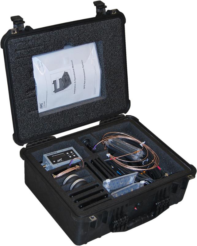
GPS Retransmission Kit by GPS Source. Photo: GPS Source
GPS Source has received a $7.5 million order for its GLI-COTTONMOUTH GPS retransmission kit from an international customer with an armored vehicle application. The kits will be used to provide armored vehicles with improved situational awareness. Shipments for the order are expected to be complete in the secondquarter of 2015.
“GPS Source is extremely pleased to be selected to provide the GPS retransmission solution for another one of our foreign military partners. Situational awareness, survivability and mission effectiveness are all improved by the use of GPS retransmission technology. Successful GPS Retransmission in the confined crew compartment of a military vehicle presents significant challenges, but one in which GPS Source has created the perfect solution,” said Robert Horton, CEO of GPS Source.
GLI-COTTONMOUTH is one of many GPS retransmission kits offered by GPS Source. The kits are available as permanent installs or man-portable. They provide GPS coverage within smaller military ground vehicle or aircraft. GPS receivers will experience no loss in signal coverage as they move out of a ground vehicle or exit an aircraft equipped with a tactical GPS retransmission kit from GPS Source.
GLI COTTONMOUTH and other GPS distribution solutions by GPS Source are in use by the U.S. Army and other military entities throughout the world. GPS retransmission technology developed by GPS Source is currently used by Net Warrior units aboard the Stryker, RG-33, and M1151. The technology is also used within the Canadian LAVIII and the French DGA SCORPION program.
Relevant GPS retransmission kits have received Safety of Flight Approval from the United States Air Force Mobility Command Systems Group and are used aboard the C17, C-130, CV/MV-22, CH-53 E/D/K, CH/MH-47, MH-60, HH60, and other host country aircraft.

 General Dynamics Mission Systems has introduced its HOOK3 combat survival radio.