The OGC CF-netCDF 3.0 encoding standard has emerged as a widely used and well supported data model and encoding for domains such as atmospheric science, oceanography, climatology, meteorology and hydrology. It supports multi-dimensional data representing space and time-varying phenomena.
The new extension to the OGC CF-netCDF standards suite specifies how CF-netCDF datasets are encoded to conform to “OGC Implementation Schema for Coverages.” Coverages are data such as the output of weather and climate forecast models, weather station and ocean buoy observations, balloon soundings, ground-base radar, satellite imagery, digital elevation models and lidar point clouds. This extension specifies how these complex multi-dimensional CF-netCDF data are encoded as OGC coverages for use in GIS or other geospatial systems.
The documents for the OGC netCDF-GMLCOV Standard are available online.
The OGC is an international consortium of more than 515 companies, government agencies, research organizations and universities participating in a consensus process to develop publicly available geospatial standards. OGC standards support interoperable solutions that “geo-enable” the Web, wireless and location-based services and mainstream IT. OGC Standards empower technology developers to make geospatial information and services accessible and useful with any application that needs to be geospatially enabled.
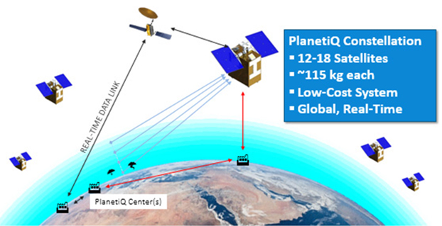
PlanetiQ has signed a contract with Antrix Corporation Limited, the commercial arm of the Indian Space Research Organization (ISRO), for the launch of PlanetiQ’s first two weather satellites on a Polar Satellite Launch Vehicle (PSLV) during the fourth quarter of 2016.
Ten more satellites are planned for launch in 2017 to complete an initial set of 12 satellites that will dramatically improve global weather forecasting, climate monitoring and space weather prediction, and enable advanced analytics for numerous industries worldwide.
The ISRO’s PSLV is among the world’s most reliable launch vehicles with 30 consecutive successful flights. It has launched 51 satellites for international customers from 20 countries, in addition to 33 Indian national satellites.
“The stellar track record of the PSLV combined with our seven-year satellite design life provides the reliability and data continuity not just desired, but required by the operational weather forecast community,” said Chris McCormick, Chairman and CEO of PlanetiQ. “Within days after launch, we will validate and start delivering high-quality data and services to our customers.”
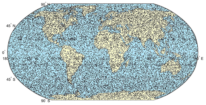
24 hours of data from 12 PlanetiQ satellites = ~34,000 occultations/day.
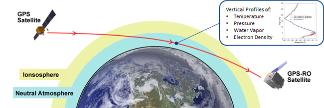
Each of PlanetiQ’s 10-kilogram microsatellites will fly PlanetiQ’s Pyxis-RO sensor, an advanced satellite weather sensor in a small package that can penetrate through clouds and storms down to the Earth’s surface. Pyxis-RO uses a technique called radio occultation to track the bending of GPS and other signals as they travel through Earth’s atmosphere, and then converts the bending angle into high-precision measurements of global temperature, pressure and water vapor in the atmosphere, and electron density in the ionosphere.
Pyxis-RO quadruples the data collection capability of radio occultation sensors on orbit today by tracking signals from all four major satellite navigation systems — GPS, Galileo, Beidou and GLONASS. With 12 satellites on orbit, PlanetiQ will collect 34,000 occultations per day, evenly distributed around the globe with high-density sampling over both land and water.
Each occultation is a vertical profile of atmospheric data with high vertical resolution, comprised of measurements less than every 200 meters from the Earth’s surface up into the ionosphere. The data is similar to that collected by weather balloons, but more accurate, more frequent and on a global scale.
“The world today lacks sufficient data to feed into weather models, especially the detailed vertical data that is critical to storm prediction. That’s why we see inaccurate or ambiguous forecasts for storms like Hurricane Joaquin, which can put numerous lives at risk and cost businesses millions of dollars due to inadequate preparation or risk management measures,” McCormick said. “Capturing the detailed vertical structure of the atmosphere from pole to pole, especially over the currently under-sampled oceans, is the missing link to improving forecasts of high-impact weather.”
The Federal Aviation Administration (FAA) has selected Harris Corporation for an eight-year, single-award indefinite delivery/indefinite quantity (IDIQ) contract with a potential value of $238 million to design and implement a system that will disseminate real-time, comprehensive weather pictures to all aviation users across the National Airspace System.
The Common Support Services–Weather (CSS-Wx) program will help minimize flight delays and cancellations by providing additional weather data with increased accuracy to more aviation consumers, supporting real-time operational planning and decision-making.
“About 70 percent of flight delays are caused by weather,” said Carl D’Alessandro, vice president and general manager, Civil Programs, Harris Government Communications Systems. “The enterprise-wide, data-sharing design of the CSS-Wx solution will reduce these delays, saving the FAA and flying public precious time and money.”
The Harris CSS-Wx system is scalable, with Open Geospatial Consortium standards for common weather formats, and highly advanced geospatial- and temporal-based filtering methods to process meteorological data. It applies expertise the company has gained from work on mission-critical weather programs for the FAA, the National Oceanic and Atmospheric Administration and the Department of Defense.
Harris has a long history of developing and integrating system solutions for the FAA in support of the National Airspace System (NAS). The company is the prime contractor for the FAA Telecommunications Infrastructure (FTI) program, which provides critical voice, data and video communications for NAS operations and mission support functions. FTI securely connects more than 4,500 national and international FAA and DOD facilities, manages over 26,000 services, and supports more than 50,000 users. Other FAA programs developed by Harris include:
The Weather and Radar Processor, which provides weather processing dissemination and display capabilities to air traffic controllers in the en-route air traffic control environment;
Datacomm, which provides air-to-ground digital data link networks to connect FAA air traffic control sites and data communications-equipped aircraft;
The NAS Voice System, which provides a secure, IP-based voice network for critical communications between air traffic controllers, pilots and ground personnel nationwide;
The Operational and Supportability Implementation System, which serves the General Aviation community in Alaska by providing weather briefing and flight planning services; and
The National Air Space Enterprise Messaging Service, which will provide the FAA with the network-centric, collaborative information-sharing capabilities afforded by System Wide Information Management.
The company PlanetiQ plans to use GNSS to make real-time weather forecasts. PlanetiQ plans to launch a commercial weather satellite constellation by 2017, composed of 12 to 18 small satellites that will capture data as GNSS satellites pass through Earth’s orbital horizon.
The satellites will use radio occultation to collect data that will supplement computer models on weather, producing more accurate and timely weather forecasts and assessments, PlanetiQ said. The satellites will measure how GPS, GLONASS, and BeiDou radio waves bend as they travel through the atmosphere, a technique that provides snapshots of temperature, pressure and water vapor, as well as insight into whether solar storms are active in the ionosphere, reports Discovery News.
Figure credit: PlanetiQ.
More than 30,000 occultation measurements can be collected each day.
PlanetiQ is one of five companies in the United States looking to commercialize weather forecasting. GeoOptics is working on a similar system and plans to launch its first satellite this year.
Explore further:
PlanetiQ President and CEO Anne Hale Miglarese discussed the project on The Weather Channel in August 2014.
Attila Komjathy, a NASA Jet Propulsion Laboratory principal investigator and adjunct professor in the University of New Brunswick’s Department of Geodesy and Geomatics Engineering, was named a Fellow of the Institute of Navigation in January for his work on remote sensing of the Earth’s ionosphere using signals from GNSS.
Esri’s interactive Severe Weather Public Information Map and U.S. Snowfall Forecast Map enable users to see winter storms, including the massive storm that’s about to hit the Northeastern United States. Here are the two maps.
Severe Weather Public Information Map
With the Severe Weather Public Information Map, users can view continuously updated weather reports and warnings from the National Oceanic and Atmospheric Administration (NOAA) and the National Weather Service, along with live weather data from AccuWeather.
Users can also explore geotagged social media from Twitter, Flickr, and YouTube related to the storms.
U.S. Snowfall Forecast Map
This map shows the projected accumulation of snowfall across the U.S. for the next 36 hours, using data from National Weather Service Digital Forecast Database. Users can step through projections in six-hour increments for a more accurate view of when and where snowfall is expected to be most severe.
GeoOptics, a satellite-based environmental data services company, in cooperation with Atmospheric and Environmental Research (AER), an environmental research and development company, has announced the initial results of an Observing System Simulation Experiment (OSSE) showing the reliability of radio occultation data in improving predictions of severe weather and flash flood events.
Using weather prediction models and data assimilation techniques, AER evaluated the potential benefit of observing Earth’s atmosphere with a vast future constellation of many hundreds of orbiting GNSS – Radio Occultation (GNSS-RO) receivers. As a case study, the model used the convective system that brought severe weather to Oklahoma in 2013, which included an Enhanced Fujita Scale-3 tornado and heavy rains.
“The improved characterization of moisture in the lowest 4-5 km of the atmosphere is very significant and, working with our colleagues at AER, we believe quite a rigorous scientific conclusion,” said Conrad Lautenbacher, GeoOptics CEO. “We see commercial provision of GNSS-RO as a valuable complement to public sector systems and a reliable, low-cost way to achieve the levels of scale tested. We are very excited by the results.”
Through collaboration begun in 2014, the two companies set out to assess the impact of vastly increased numbers of GNSS-RO profiles on regional weather forecasting within the context of a global weather satellite system. Oklahoma was the region of focus of the study, an area with a history of severe weather phenomena. Today’s total global GNSS-RO profiles number approximately 1,800 per day, of which 0.64 profiles per day are readings taken over Oklahoma.
In the study, AER and GeoOptics modeled from 50,000 to 2,000,000 global profiles per day through the deployment of the planned CICERO satellite constellation. Such large scale would correspondingly increase the profiles per day over Oklahoma to between 17 and 700.
“We see commercial remote sensing and particularly the GNSS-RO technology as a paradigm change in developing and maintaining a cost-effective, next-generation operational observational infrastructure for environmental prediction,” said AER President Ron Isaacs. “The superb GNSS-RO technology knowledge base at GeoOptics provides an ideal and exciting complement to AER’s decades-long experience in today’s operational remote sensing and weather prediction practices, which include the current use of GNSS-RO sensing.”
GNSS-RO profiles provide measurements of atmospheric temperature, moisture, and pressure with a precision unrivaled by other space-based techniques. The RO sensor gathers this information by precisely observing perturbations imposed on ubiquitous GPS radio signals as they pass through the atmosphere. Today, nearly 3,000 organizations in more than 80 countries use RO data in Numerical Weather Prediction (NWP) and research. NOAA’s own studies show that more accurate mid- to long-term forecasts can be made up to 15 hours sooner using the data collected from the current limited set of experimental GPS-RO sensors.
GeoOptics plans to launch an array of powerful GNSS-RO sensors on its CICERO constellation of low-Earth-orbiting satellites. The rollout of the constellation will begin in the third quarter of 2015 and will deliver more than 50,000 global profiles per day when fully deployed. As demand grows, the 24-satellite CICERO constellation will be expanded to carry additional and complementary instruments, such as scatterometry and gravity sensors.
“GeoOptics will advance a small satellite observing model that starts with GPS radio occultation,” Lautenbacher added. “We believe an integrated private company like ours can deploy such systems for a fraction of current costs to the government.”
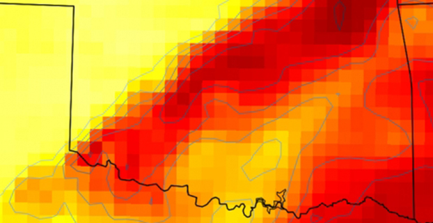
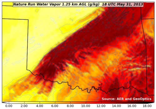
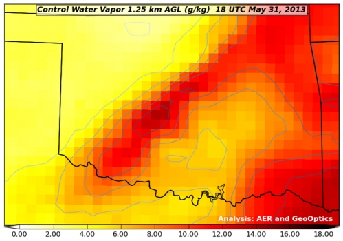
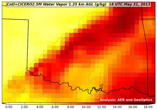
Figure 1. “Nature Run” (the truth reference) atmospheric water vapor at about 4,000 feet above the ground. The yellow-to-red color scale (bottom of figure) indicates how much water vapor is present, i.e., yellow is dry and red is moist. This realization of atmosphere moisture during an Oklahoma severe weather outbreak in May 2013 is the yardstick against which our assimilation experiments are compared for realism. It has a horizontal resolving power of about 1 1/4 mile (i.e., 2 km).Figure 2. Atmospheric water vapor analysis using conventional observing system. Valid time, vertical level and color scale are the same as in Figure 1. Note that the data fusion experiments use a bigger grid than the Nature Run (Figure 1) with a horizontal resolving power of about 11 miles (i.e., 18 km).Figure 3. Atmospheric water vapor analysis using conventional observing system + CICERO radio occultation observations. The distribution of water vapor in this analysis is much closer to the Nature Run (Fig. 1) in pattern and magnitude than the Control result (Fig. 2).
Esri is offering a Severe Weather Public Information Map that charts instances of severe weather throughout the United States and Canada. Weather events tracked include snowstorms, tornadoes, floods, hail storms, wind storms, and short-term weather warnings issued by the National Oceanic and Atmospheric Administration (NOAA).
The map features live feed layers. Users can click on reports and warnings to receive information about the specific location and read a short description about the issue. Radar is provided by AccuWeather and Environment Canada as part of the Esri Disaster Response Program.
Under the theme “Taking the Pulse of the Planet,” 275 members of the GEO community from more than 45 countries will chart the next steps in creating and implementing a Global Earth Observation System of Systems (GEOSS) during the Group on Earth Observations (GEO) Eleventh Plenary Session. The session will be held November 12-14 in Geneva, Switzerland.
A highlight of the conference will be announcement of the winners of the GEO Appathon, a global app development competition built on the 80-million-plus resources available through GEOSS. The Appathon attracted 250 competitors from 50 countries, and will generate easy-to-use decision tools for mobile devices and computers.
GEO’s mandate is to harness the power of Earth observations from sources across the globe to provide more and better information to leaders in government, industry, and civil society confronting fundamental decisions affecting people and societies worldwide. One key GEO initiative that will be highlighted during the meeting is developing a comprehensive system to monitor the availability and quality of fresh water, in partnership with the World Health Organization, the UN Environmental Programme and other UN agencies as part of the UN Sustainable Development agenda.
GEO is leading the creation of an Africa-wide technological and human infrastructure so decision makers have the capacity to access and use Earth observations in making key decisions. To strengthen agricultural activity and reduce market volatility, GEO is coordinating the assessment of growing conditions of the world’s major crops through a combination of regional expertise, ground observations and analysis of meteorological and satellite data.
GEO is a voluntary partnership of governments and organizations that envisions “a future wherein decisions and actions for the benefit of humankind are informed by coordinated, comprehensive and sustained Earth observations and information.” Members include 94 nations and the European Commission and 77 participating organizations comprised of international bodies with a mandate in Earth observations.
GEO’s agenda spans nine Societal Benefit Areas, including agriculture, biodiversity, climate, disasters, ecosystems, energy, health, water and weather.
A hail suppression project dubbed RO-BERTA by the University of Applied Sciences, Rosenheim (Germany), has been selected the winner of the European Satellite Navigation Competition’s (ESNC) University Challenge. Judged by an international expert jury, the University Challenge is a special prize to reward innovative ideas emerging from Europe’s universities.
The Hail Navigator system is designed to reduce damage caused by hail. Based on the premise of suppressing the formation of hail by injecting silver iodide into clouds, Hail Navigator combines navigation with a precipitation reporting system that can guide pilots to optimal locations for hail suppression missions.
The system is complemented by weather observations (including precise times and locations) reported by local citizens via a smartphone app, which aids the validation of weather prediction models. These models constitute an important factor in deciding whether a hail suppression flight is necessary.
The project team was awarded the prize on October 23 in Berlin at the ESNC Awards Ceremony. More than 300 guests attended, representing the top European players in the navigation sector. In addition to cash, the prize includes support through the GNSS Research & Applications Centre of Excellence (GRACE) and a free ticket to the Munich Satellite Navigation Summit 2015.
“Winning this prize once again demonstrates that interdisciplinary cooperation is feasible and successful,” said Project Manager Peter Zentgraf. “The positive feedback the competition provides helps drive our many students to continue their dedicated work, which made it possible to reach our project goals.”
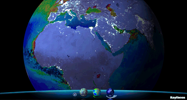
Available for iPhone, iPad and Android, VIIRS View provides mobile device users a look into the type of data meteorologists and climatologists use every day to track the weather and monitor Earth’s environment.
Based on data generated by the Visible Infrared Imaging Radiometer Suite aboard Suomi NPP, VIIRS View combines visible light imagery, low-light nighttime imagery and ocean chlorophyll concentration onto a full Earth globe, rotatable and zoomable on any location on the planet.
A desktop version of the VIIRS View app, launched in February, has been downloaded more than 90,000 times.
An original large format VIIRS View interactive tabletop display is being shown at Raytheon Booth #203 at the the 30th Space Symposium, being held this week in Colorado Springs, Colorado. GPS World Defense Editor Don Jewell is providing coverage from the symposium.
The app can be downloaded by searching VIIRS View at the Google Play and Android stores, or by clicking here:
The storm chasing and weather community is honoring three storm chasers killed in an Oklahoma tornado on Friday. Tim Samaras, his son Paul Samaras, and Samaras’s chase partner Carl Young are being honored via the Spotter Network, where their initials are being spelled out.
The Spotter Network is a website used by storm chasers to follow weather movements. Users have been adding position locations to spell out the initials TS, PS, and CY, shown here in an image at sfgate.com.
The Samarases were well known to TV viewers, having been prominent subjects of the Discovery Channel series “Storm Chasers” and frequent contributors to The Weather Channel. They weren’t working for either channel last week, both networks said.
The Weather Channel Companies announced they will partner with hyperlocal data company PlaceIQ to provide advertisers with new audience targeting that can deliver highly contextually relevant ads to consumers. With 30 million monthly mobile users, The Weather Channel can offer hyperlocal audience targeting at scale. This targeting is now available on The Weather Channel iPhone App and will be rolling out on The Weather Channel Android App in July and all mobile platforms later this year.
PlaceIQ extracts intelligence from large amounts of place, social, and mobile location-based data to create hyperlocal, targetable audience profiles informed by time of day as well as location, giving advertisers the power to connect with consumers. These anonymous audience profiles can provide powerful targeting opportunities for advertisers. For example, financial services clients can target ads to mobile phones in areas with a high propensity for business travelers, such as airports during peak commuting hours, or in areas with a high concentration of hotels in the morning or evening that score high for business travelers. An ad on The Weather Channel app can be served during lunch on mobile phones on certain blocks populated with office workers, or served targeting late-night diners in an area that has a high concentration of nightlife and social activity.
"Consumers expect to receive the most accurate local weather news and information when they use The Weather Channel mobile products, which gives us the opportunity — and our advertisers the advantage — to deliver messages highly targeted to their location that will feel completely organic to their user experience," said Patrick McCormack, vice president, mobile sales and strategy, The Weather Channel Companies. "We feel strongly that our premium content and ability to target a specific mobile audience provides an unparalleled ad solution to our advertising clients."
"The combination of PlaceIQ's hyperlocal audience targeting, with The Weather Channel's tremendous reach and ability to transform hyperlocal impressions into specific audiences, is an extremely powerful one. The combination of weather, location and audience creates a set of offerings we think represent true innovation in mobile advertising, and we're extremely excited to partner with The Weather Channel to deliver this to market," said Duncan McCall, CEO and co-founder, PlaceIQ.
The product is launching with a number of high profile advertisers, including Chevy Silverado,Frito-Lay, and the Ram Truck brand, among others.