On March 9, the Institute of Navigation (ION) is hosting a complimentary webinar on “Signal Quality Monitoring Based on Chip Domain Observables: Theory, Design, and Implementation.”
The webinar is presented by Xiaowei Cui and Mingquan Lu, professors at Tsinghua University, China.
Signal quality monitoring (SQM) is a technique utilized by satellite- and ground-based augmentation systems (SBAS/GBAS) to detect potential hazardous deformations in signals and better protect integrity for safety-critical users.
The next generation of SBASs will incorporate dual-frequency multi-constellation (DFMC) techniques, for which SQM is important since signal deformations might be the largest source of uncertainty in ranging error after first-order ionospheric delays are eliminated.
However, the performance bounds of the traditional multi-correlator-based SQM technique face some challenges because of the raised requirement on detection sensitivity by dual-frequency ionosphere-free measurements and multiple modulation modes of civilian signals from multi-constellation techniques.
To mitigate the challenges and improve overall performance, SQM based on chip domain observables (CDOs) is emerging but has not yet been systematically studied.
Presenters will propose a design methodology for CDO-based SQM, consisting of derivations and corresponding massive simulations. Correctness and effectiveness are assessed to confirm the methodology, and a simplification process by checking the sensitivity of CDOs is demonstrated in terms of implementation.
Space is limited; register at ion.org to secure a spot.
As drones are becoming a popular mode of delivery, surveillance, inspection, and mapping, they need to be resilient to spoofing. On Dec. 15, Septentrio hosted a webinar about detecting, mitigating, and protecting against spoofing on UAV autopilots.
Topics discussed included how GPS/GNSS technology fit into the autopilot ecosystem, signs of GPS spoofing and UAV vulnerabilities, realistic demonstrations of spoofing, how to mitigate spoofing, and autopilot compatibility with resilient GPS modules.
Wim De Wilde, R&D Team Leader at Septentrio, facilitated a presentation on vulnerabilities of UAVs. It included detecting signal anomalies and inconsistencies in GPS receivers to flag spoofing, technology used to spoof or hijack drones, and recommendations to prepare autopilots before take-off.
The next presentation, by Ramon Roche, General Manager at DroneCode Foundation and PX4 Autopilot, explained PX4 products that have built-in resilient GPS receivers. Greg Lopes, Hardware Design Engineer at Zipline, further elaborated about the importance of having robust, resilient GPS receivers to mitigate spoofing as it relates to Zipline’s delivery drones.
Figure 1
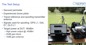
One of the final presentations was a case study of an in-field simulation and spoofing test by Jack Ackermann, Director of Product Line Management at Spirent. The case study preparation and test results that were discussed in the webinar can be seen in Figures 1 and 2.
Septentrio holds frequent webinars, with knowledgeable guest speakers, regarding topics related to GPS/GNSS technology. Find previous webinars and learn about upcoming ones here.
A Nov. 17 webinar will focus on ways to deter attacks on and interference with GPS satellites and signals. The webinar takes place 2:30-3:30 p.m. EST; register for free.
Rep. John Garamendi (D-CA) will provide opening remarks for the webinar, which is co- sponsored by Domestic Preparedness Journal and the Resilient Navigation and Timing Foundation. Garamendi is the chair of the House Armed Services Readiness Subcommittee and has long been concerned about the vulnerability of America’s GPS.
“America’s over-reliance on GPS makes it a high priority target for a wide range of bad actors,” said Dana A. Goward, president of the Resilient Navigation and Timing Foundation and one of the webinar moderators. “And, since other nations, such as China, Russia and Iran, have terrestrial systems they can use when space is not available, the U.S. is at a strategic disadvantage.”
This “technology resilience gap” is one of several dangers that could lead to armed conflict that webinar panelist George Beebe discusses in his book The Russia Trap. His concern is that having such a pronounced relative weakness can invite meddling and exploitation by adversaries. Even if done on a small scale, this could lead to a series of escalating responses ending in an unintended, much more serious conflict that neither party wants.
Beebe is vice president and director of studies at the Center for the National Interest. He spent more than two decades in government service as an intelligence analyst, diplomat and policy advisor, including service as director of the CIA’s Russia analysis and as special advisor to Vice President Dick Cheney for Russia/Eurasia and Intelligence Programs.
Eliminating the gap between the United States and its adversaries is key to protecting GPS and the nation, according to webinar panelist Greg Winfree, director of the Texas A&M Transportation Institute. Winfree previously served as an assistant secretary for the U.S. Department of Transportation. While acknowledging there is no single answer, he has asserted that providing at least one alternative system will go a long way toward “getting the bullseye off GPS.”
The third webinar panelist, Scott Pace, has supported Winfree’s approach. Pace is the director of George Washington University’s Space Policy Institute and former executive director of the National Space Council. He has commented that having an alternative to GPS will contribute to national security and improve global stability. It will “lower the pressure on us to escalate and respond” should GPS satellites be damaged or services disrupted.
Top-level current, former PNT leaders to discuss findings
A “Who’s Who” of positioning, navigation, and timing (PNT) leaders will gather virtually at 11 a.m. PDT/2 p.m. EDT on May 5 to discuss findings of the U.S. Department of Transportation’s (DOT) GPS Backup Technology Demonstration, which took place in 2020.
Included in the “What Technologies Can Secure GPS?” webinar will be DOT Research and Technology leaders from the Obama and Trump administrations, Greg Winfree and Diana Furchtgott-Roth, and currently serving career DOT officials Karen Van Dyke and Andrew Hansen.
Robert Hampshire, current DOT Acting Assistant Secretary for Research and Technology, will make his first public appearance discussing PNT issues.
The event is sponsored by George Washington University’s Space Policy Institute and moderated by Scott Pace. Pace served as the executive director for the Space Council in the last administration. In that capacity, he was responsible for a series of directives and policies impacting PNT in the United States.
Describing the plan for the event, the formal announcement states, “Three separate laws have required the U.S. Department of Transportation (DOT) to back up and complement the Global Positioning System, subject to congressional appropriations. To provide a roadmap, in January the department released its Complementary PNT and GPS Backup Technologies Demonstration Report.”
The program will open with remarks from Scott Pace, director of the Space Policy Institute, who will also moderate the discussion. Hampshire will offer introductory remarks. Van Dyke and Hansen will follow up with a presentation of the report. George Washington University Adjunct Professor Diana Furchtgott-Roth and the Texas Transportation Institute’s Greg Winfree will provide comments.”
A question-and-answer session will follow the addresses and discussion.
The event is free and open to the public, though advance registration is required. Registrants will receive a Zoom link. The webinar will also be recorded.
The Institute of Navigation (ION) is hosting a webinar April 20 on “GNSS interference mitigation: A measurement and position domain assessment.”
The webinar takes place at 11 a.m. EDT and is presented by Daniele Borio and Ciro Gioia, authors of a paper on the topic.
Summary
Modern GNSS receivers have to withstand significant levels of interference in order to operate under harsh conditions, such as in the presence of jamming and of other Radio Frequency (RF) threats. A possibility is to implement pre-correlation interference mitigation techniques that operate directly on the samples provided by the receiver front-end. The speakers’ paper provides an assessment of five interference mitigation techniques at the measurement and position level.
The analysis focuses on the adaptive notch filter (ANF) and on four robust interference mitigation (RIM) techniques. Several data collections were performed in the presence of jamming, and the data were used for the analysis that shows that RIM techniques do not introduce biases at both the measurement and position level. While the ANF delays pseudorange measurements, the biases introduced are predominantly common to all the observations with a negligible impact on a single point positioning (SPP) solution.
The webinar will be presented by Gerhard Kruizinga, navigation engineer, Mars 2020 Navigation Team chief, NASA’s Jet Propulsion Laboratory, and moderated by Frank van Diggelen, ION president.
“We are honored to have the Navigation team chief of this historic mission, Gerhard Kruizinga, present his first-hand account of getting NASA’s Mars 2020 Perseverance Rover from the launch pad to a safe landing on Mars,” van Diggelen said.
The precision landing required very high-precision interplanetary navigation and accommodation of entry guidance target requirements, planetary protection requirements and propellant allocation for trajectory correction maneuvers.
The main navigation objective was to predict the trajectory accuracy at atmospheric entry, such that the entry descent and landing system requirements were satisfied for a safe landing. This presentation discusses the planning to meet all navigation requirements and the actual navigation performance during cruise and landing.
The European Space Agency (ESA) has launched a call for proposals to demonstrate the capabilities of new 5G cellular networks to support positioning and timing applications to complement satellite navigation.
5G will bring higher speed, larger traffic capacity and ultra low-latency (or signal delay) communications. 5G will also usher in a range of new possibilities for positioning, navigation and timing (PNT).
ESA is inviting proposals to implement pilot projects to demonstrate the viability of 5G PNT solutions in a number of use cases:
Indoor PNT for Industry 4.0, as needed to support the operations of smart warehouses and factories or smart city applications requiring transition from indoor to outdoor environments.
Outdoor applications where a robust back-up to satellite navigation is essential to meet safety requirements, such as autonomous driving or drone navigation.
Applications where robust time and frequency synchronization is necessary, both in outdoor as well as indoor environments, like smart energy grids or the 5G networks themselves.
5G networks will allow new types of measurements made possible by advanced antennas and by new positioning signals at higher frequencies, at both base stations and the user receivers. 5G networks will also bring enhanced connectivity to improve cloud-based positioning applications and value-added services.
While satellite navigation works optimally in outdoor environments with a wide view of the sky, 5G PNT has the potential to bring PNT to deep urban canyons in high-rise city centers and indoor warehouses, wherever 5G networks are deployed.
The combination of satellite navigation and 5G brings the promise of high performance, secure and resilient PNT services, as well as a seamless application of PNT applications from outdoor to indoor environments and from rural to urban areas, ESA said.
This call for ideas is supported through ESA’s Navigation Innovation and Support Programme (NAVISP), working with European industry and academia to develop innovative navigation technology.
Webinar on PNT 5G
To support the call, an information webinar is being held on 21 October, in which the various PNT 5G use cases will be presented by key speakers from each sector. Details of the call and how to apply will also be presented by ESA.
A networking platform has also been established to allow webinar participants and general stakeholders interested in the call to get in touch and discuss possible cooperation. This platform will be kept open during the entire period of the call’s duration.
For more information on the call and the agenda of the webinar visit ESA’s NAVISP website.
To register for the webinar and the networking platform, click here.
GPS World, in conjunction with Spirent Federal Systems, will be hosting a webinar on Oct. 8 that will cover GPS program updates, as well as the program’s role in the Space and Missile Systems Center’s (SMC) space enterprise architecture.
The event will also discuss the effects of COVID-19 and any future plans for the GPS program.
Event speakers will include Col. Ryan Colburn, director of SMC’s Spectrum Warfare Division; Shawn Ryan, BAE Systems Navigation & Sensor Systems director of business development for SMC; Mike Shepherd, associate director of business development at Collins Aerospace Mission Systems; and Christopher Hogstrom, engineer at Spirent Federal Systems.
Col. Ryan Colburn leads a team charged with designing and integrating the United States Space Force’s current and future integrated satellite communications and position navigation and timing enterprise architectures. He works with military, commercial, allied and government partners to ensure SMC is able to design, acquire, integrate and field the space systems needed to support today’s warfighters.
Shawn Ryan provides local leadership for all SMC and Los Angeles Industrial NSS efforts and engagement. NSS, headquartered in Cedar Rapids, Iowa, develops, designs and manufactures the most advanced GPS receivers and anti-jam GPS antenna electronics for military applications.
Mike Shepherd leads integrated business development for A-PNT, FVL, TITAN and JADC2. Previously, he was the senior manager of the ground U.S. military GPS receiver business and managed major accounts for all branches of the U.S. military users of GPS and A-PNT systems.
Christopher Hogstrom joined Spirent Federal in 2020. He currently supports various engineering efforts as well as customer trainings and product demos. He has worked extensively with adaptive beamforming and its applications in GPS anti-jam technologies. Hogstrom received his Bachelor and Master of Science in Electrical engineering from Brigham Young University.
Recent GPS World webinars have focused on a variety of proven, resilient technologies to combat GNSS and positioning, navigation and timing (PNT) vulnerabilities in critical infrastructure.
Now a Sept. 17 GPS World webinar focuses on how PNT monitoring can further protect critical systems from these vulnerabilities through continuous monitoring and improvement.
The Orolia-sponsored webinar is free. It is scheduled for 1 p.m. EDT / 10 a.m. PDT / 7 p.m. (1900h) Central European Time. Register here.
Protecting critical infrastructure is now a national priority for the U.S. and allied countries. Similar to cybersecurity for network systems, effective GNSS and PNT protection involves identifying and monitoring weak entry points, knowing where and when an intrusion occurs, and providing data about new threats to help strengthen the system going forward. Its value applies across all critical infrastructure sectors such as telecom, power grids and data centers.
Webinar speakers include:
John Fischer Vice President, Advanced R&D, Orolia
For more than 15 years, Fischer has been part of Orolia where he works with global navigation satellite systems, wireless, positioning navigation and timing, as well as specialized systems for its customers. Prior to joining Orolia, he specialized in wireless telecom as a founding member of two startups: Aria Wireless in 1990 and Clearwire Technologies in 1997. At Clearwire, he served as chief technology officer in creating wireless broadband equipment for internet connectivity. Early in his career, Fischer worked as a systems engineer in radar, EW, and command and control systems at Sierra Research and Comptek Research. He holds master’s and bachelor’s degrees in electrical engineering and computing engineering from the State University of New York at Buffalo.
Tim Frost Strategic Technology Manager, Calnex Solutions
Tim Frost is a specialist in next-generation synchronisation techniques, having worked with Zarlink Semiconductor, Symmetricom and now Calnex Solutions on packet-based synchronisation technologies. He is an active contributor to the ITU-T, and has also contributed to the AVnu Alliance, Small Cell Forum, Metro Ethernet Forum and IETF. He has a BSc. in Electrical and Electronic Engineering from the University of Leeds, and a MSc. in Computer Systems Engineering from the University of Manchester.
Francisco Girela Americas Tech Responsible, Seven Solutions
Francisco Girela is the Americas Tech Responsible at Seven Solutions. He holds a Master’s degree in Telecommunications Engineering from the University of Granada. After some time in the private sector, Francisco joined the Timing Keepers group at the same university as a researcher. During his research, he specialized in ultra-accurate time transfer systems and he focused on the development of the White Rabbit technology. He combines his work for Seven Solutions with his studies for a Ph.D. in Telecommunications Engineering. This combination has provided Francisco with a strong technical background on high-accuracy time synchronization and deep knowledge on timing applications in industrial sectors.
The 1,174 page set of reports are comprehensive and document the first phase of what is intended as a multi-phase effort.
Graphic: RIN and RNTF
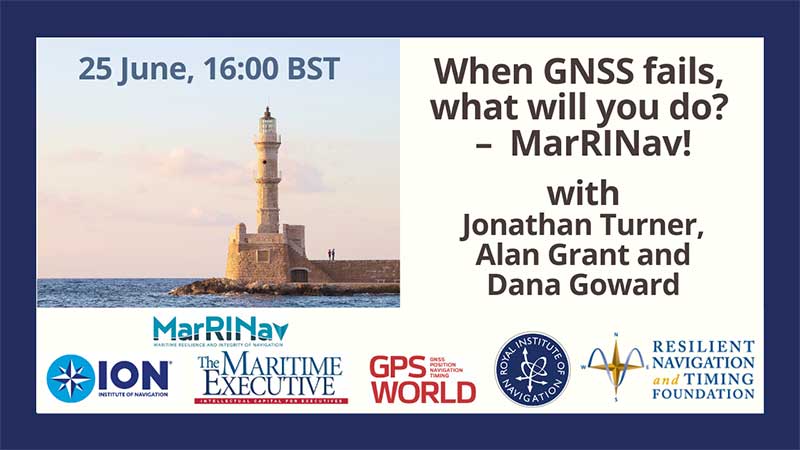
The webinar will present how maritime positioning requirements were systematically developed; an assessment of current and future positioning systems to deliver the required performance and integrity; rigorous gap analysis, showing where performance falls short, as well as options to solve these issues; and a roadmap of steps needed to take — and by whom — toward maritime resilient positioning.
Webinar speakers will include Jonathan Turner of the MarRINav project team, Alan Grant of the Royal Institute of Navigation and Dana Goward of the Resilient Navigation and Timing Foundation.
The Institute of Navigation (ION) will be hosting a complimentary webinar, “Impact of Sample Correlation on SISRE Overbound for ARAIM,” at 12 p.m. ET on May 28.
This topic was originally presented at ION GNSS+ 2018 and published in the Spring 2020 issue of Navigation, Journal of the Institute of Navigation, Volume 67, No. 1, pp 197-212, by Dr. Santiago Perea Diaz, Prof. Michael Meurer and Dr. Boris Pervan.
According to ION, this paper analyzes the effect of error correlation on the SISRE bounding for GPS and Galileo satellites. For a given period of data collection, it computes the effective number of independent samples contained in a dataset applying an estimation variance analyses. Results show that the time between effective independent samples is highly dependent on the constellation and onboard clock type. On one hand, GPS satellites equipped with Rubidium clocks exhibit significantly longer error correlation than those with onboard Cesium clocks. On the other hand, Galileo satellites show substantially shorter correlation time among samples with less variability on a monthly basis, ION added.
This paper also introduces a methodology to compute SISRE bounding accounting for the limited number of independent samples, ION said. Using a Bayesian approach, it computes the so-called uncertainty factor by which the Gaussian distribution needs to be inflated in order to account for the observation data independence.
According to AUVSI, the series will offer information, insights and insider knowledge covering a number of topics, including drone delivery, public safety, connectivity, and other aspects of the unmanned systems and robotics industry.
These webinars are being held because of the rescheduled Xponential 2020 conference. Xponential 2020 was originally scheduled to take place May 4-8 in Boston, but is now tentatively scheduled to take place Aug. 9-12.
AUVSI offered an overview of the webinars, which are all complimentary.
Digital Twins — The Future of Virtual and Mixed Reality Robotic Avatars Date: Monday, May 4, 3-4 p.m. EDT Speaker: Peter Haas, associate director, Humanity Centered Robotics Initiative, Brown University
Hass will describe how advances in mixed and virtual reality control will lead to a UX revolution for avatar-based robotic teleoperation, where the manipulation of digital twins will translate to manipulation of a robot — or robots — in the physical world. Register here.
Drone Delivery Supporting Public Health Date: Tuesday, May 5, 3-4 p.m. EDT Speakers: Eric Gardiner and Eric Lasker, federal business development, Zipline
Executives from Zipline will describe how drone delivery has evolved through the Federal Aviation Administration UAS Integration Pilot Program and is now being adapted to help community healthcare partners respond to COVID-19 in the United States. Register here.
NASA’s Vision and Role to Enable Urban Air Mobility Date: Wednesday, May 6, 3-4 p.m. EDT Speakers: Robert Pearce, associate administrator, NASA Aeronautics Research Mission Directorate, and Brian Wynne, president and CEO, AUVSI
Pearce will review initiatives to enable small UAS operating at low altitude through a UAS Traffic Management System and large UAS operating in higher altitude airspace with definitive flight experiments to validate key standards, such as detect-and-avoid technology. Wynne will host a discussion with Pearce about his full vision for future aviation, including what the next 50 years has in store for commercial airline travel and urban air mobility. Register here.
Advancing Autonomy Through DARPA Challenge to Benefit First Responders Date: Thursday, May 7, 3-4 p.m. EDT Speaker: Dr. Timothy Chung, program manager, DARPA Tactical Technology Office
DARPA’s Subterranean Challenge engages international teams to deploy autonomous systems — rolling, walking, flying and floating — to remotely map, identify and report on artifacts discovered along underground courses. Chung will discuss persisting challenges with robotics, how teams are succeeding in competition while advancing unmanned capabilities and how these lessons can benefit first responders. Register here.
Aerial Connectivity Joint Activity — Bridging the Gap Between Cellular and Aviation Date: Friday, May 8, 2-3 p.m. Speaker: Mark Davis, technical lead, ACJA
Davis will explore the latest roadmap for aviation and cellular communications, including how recent initiatives such as Aerial Connectivity Joint Activity (ACJA) are aimed at providing a standards framework to enable unmanned aerial cellular. ACJA is a joint activity between GSMA, which represents the interests of mobile operators worldwide, and the Global UTM Association, a non-profit consortium of worldwide Unmanned Aircraft Systems Traffic Management stakeholders. Register here.

 On March 9, the Institute of Navigation (ION) is hosting a complimentary webinar on “Signal Quality Monitoring Based on Chip Domain Observables: Theory, Design, and Implementation.”