The webinars, GeoBits, which are based on the organization’s GeoBytes webinar series, will be free and recorded.
The first webinar, titled “The First GeoBit: Career Opportunities in Land Surveying,” will take place at 2 p.m. Eastern time on April 30. This webinar, hosted by licensed land surveyor Ryan Swingley, will discuss career opportunities in land surveying. Swingley will explain what surveying is and how it affects the physical world around us. The webinar, designed for kids in the eighth to twelvth grades, will cover different career segments in land surveying and the future job outlook. Register for it here.
The second webinar, titled “The Second GeoBit: Studying Population Change using Interactive Mapping Tools,” will take place at 2 p.m. Eastern time on May 5. The webinar, hosted by geographer Joseph Kerski, will Explore how to examine patterns of population change, migration and demography with interactive web maps and web mapping applications. During the webinar, designed for middle school students, Kerski will investigate how 2D and 3D maps can be accessed, modified and turned into online presentations. Register for it here.
The third webinar, titled “The Third GeoBit: Product Management, 3D and maps,” will take place at 2 p.m. Eastern time on May 8. Hosted by Esri Group Product Manager Chris Andrews, the webinar will cover product management and how to guide the development of a product from concept to sale to use by a real-world person to accomplish work. Register for this webinar, targeted for middle school students, here.
Established in 1934, the American Society for Photogrammetry and Remote Sensing is a scientific association serving over 2,000 professional members around the world, providing its members professional development through education and networking experiences, professional certification, publications, scholarships, and other services.
New series of free webinars for construction, geopositioning and agriculture facilitate learning
Topcon Positioning Group is launching a free webinar program for the construction, geopositioning and agricultural sectors, exploring key topics affecting the industry and providing the latest updates and project management solutions.
The Topcon Talks series, consisting of numerous informative webinars, has been created in response to the ongoing COVID-19 pandemic and aims to provide those working from home with valuable educational resources, while maintaining steady communication with Topcon customers, dealers and the wider industry.
The webinars will focus on a range of topics such as improving productivity using digital construction workflows, overcoming barriers to technology adoption, and more practical how-to sessions for customers and dealers on specific Topcon solutions.
The webinars will be delivered by a range of Topcon experts, with input from several other industry specialists, and cover a multitude of topics including:
Always One Step Ahead – an overview of Topcon’s latest product developments, market focuses and acquisitions
State of the Industry series – looking at the barriers to technology adoption in construction, such as attracting talent and bridging the skills gap
Detailed technical sessions showcasing latest hardware, software and web services to get the most out of Topcon solutions
The content series is live on the site, with new sessions taking place regularly over the coming weeks. All sessions are free to attend, and those wanting to participate will first need to register on the Topcon website.
“Everyday life has changed very quickly, and businesses across the world are having to adapt. At Topcon, we are working tirelessly to help the industry weather this storm. We’re aware that at this time, the majority of people are working from home, and we want to continue to support our customers and colleagues as much as possible,” said Ron Oberlander, vice president of global professional services at Topcon Positioning Group. “That’s why we’ve developed this webinar series — to provide an opportunity for continued professional development so that professionals can remain as productive as possible during this challenging time and be in the best position possible to accelerate the industry’s recovery when we come out the other side.”
The webinars are also recorded and uploaded to the site once complete, so those who are unable to attend the session can access the content in their own time.
A free GPS World webinar on Nov. 21 tackles a new frontier, if not the final one, for GNSS. “Developments in Space GNSS Navigation,” sponsored by NovAtel, brings together experts from NASA, ESA, NovAtel and Spire (the CubeSat company) to discuss how they’re taking GNSS capabilities beyond Earth’s boundaries.
Navigating through space has long proven to be challenge for aerospace engineers and professionals because of the complex combination of technology and cost required for success.
However, with advancements in GNSS and receiver technology, organizations and nations around the world are increasingly interested in space exploration activities.
Today, the space industry is seeing GNSS technology used in low-Earth orbit (LEO) and highly elliptical orbit scenarios.
In this webinar, speakers from NASA, ESA (the European Space Agency), NovAtel and Spire will examine emerging trends regarding the usage of GNSS technology in the space industry, including an increasing need for situational awareness while navigating through space and the ability to service satellites while in orbit.
These experts will also provide a look into their own experiences with a variety of ambitious space projects and applications.
Speakers include:
Werner Enderle, Head of Navigation Support Office, ESA European Space Operations Center
Benjamin Ashman, Aerospace Engineer, NASA
Erin Kahr, Critical Safety Systems, NovAtel
Dallas Masters, GNSS Program Manager, Spire
Date: Thursday, November 21, 2019 Time: 1 p.m. EST / 10 a.m. PST / 7 p.m. (1900h) Central European Time
Dean Kemp, defense segment manager for NovAtel, has joined the speakers’ panel for the June 27 complimentary webinar, Advanced Simulation Test Systems for Controlled Reception Pattern Antennas. He will present unique content alongside Lisa Perdue, simulation product manager for Orolia, and Stéphane Hamel, director of testing at Orolia.
Kemp has over 20 years of academic, industrial and business experience in engineering products and services. He spent a significant part of his career involved in antenna design and development, including controlled reception pattern antennas (CRPAs) for GPS anti-jam systems. As Defense Segment Manager, he is committed to precise, assured positioning and timing to address the needs of Navigation Warfare (NAVWAR) professionals and is dedicated to delivering high-quality products into the defense markets.
He holds a Ph.D. in antennas, radiowave propagation and computational electromagnetics from the University of Liverpool and an MBA from the University of Warwick. Prior to joining NovAtel, he worked at API Technologies, Cobham and Cobham Technical Services. His key technical skills include antenna/RF/microwave engineering, software development (Matlab, Fortran, VBA, Python), data analysis and processing, and test and measurement.
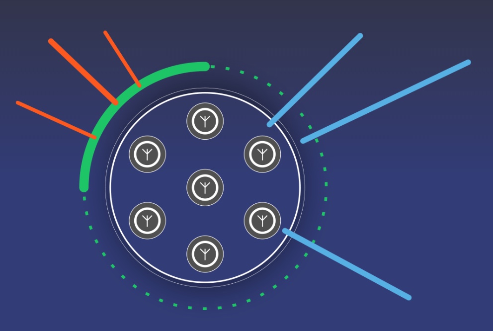
CRPAs are advanced, multi-element antenna solutions designed to protect a GNSS/GPS receiver from jamming sources. When combined with antenna electronics, they form an anti-jam antenna system (AJAS). These systems utilize several available technologies and vary in the number of elements.
This webinar will cover the basics of AJAS and CRPA, and the methods used to test them. Details on simulation system configurations, calibration techniques, and use case examples will also be presented. The webinar is sponsored by Orolia, a global provider of GPS/GNSS and resilient PNT solutions to support military and commercial applications.
Protection from jamming has emerged as the key concern of of both national and organizational/corporate infrastructures. The world abounds in bad actors, and systems based on GNSS signals are uniquely vulnerable. A basic component of any anti-jamming (AJ) strategy is a shielded antenna. An upcoming webinar, June 27, gives a primer and several advanced looks at developing such an antenna-based AJ campaign. Register here for the complimentary webinar.
Anti-jam antennas use techniques, such as nulling or beam-forming, to mitigate the effects of interfering signals. (Image: Orolia)
Controlled reception-pattern antennas (CRPAs) are advanced, multi-element antenna solutions that protect a GNSS/GPS receiver from jamming sources. When combined with antenna electronics, they form an anti-jam antenna system (AJAS). These systems utilize several available technologies and vary in the number of elements.
CRPAs will play an increasing role in the GPS/GNSS landscape. Initially developed in the military domain, they are now entering the civilian market and are poised to bring their benefits to the fields of aerospace, ground transportation, autonomous driving and others. Engineers working with GNSS systems that employ CRPAs and multi-element antennas need special test systems since they need to replicate very specific test conditions that are impossible with live signals.
These complex antenna systems require advanced GNSS simulation equipment in order to be designed and validated, as well as to test their performance. These test systems come in two forms — an anechoic chamber system used to test the CRPA antenna over the air, and a wavefront simulator used to test the antenna electronics with a direct cable connection.
Webinar speakers:
Perdue
Lisa Perdue, Product Manager, Orolia. Perdue is an expert in testing critical GPS and GNSS systems. She has trained hundreds of engineers and technicians who are responsible for high-reliability positioning, navigation and timing applications. She took a lead role in the development of the first GNSS Vulnerability Test System and speaks widely on the topic at many industry conferences.
Hamel
Stéphane Hamel, Director, Testing, Orolia. With a career spanning more than 20 years in engineering test and RF, Hamel has developed many innovative and large-scale products to test semiconductor devices, radios and GNSS receivers. In 2014, he founded Skydel, now part of Orolia. Hamel is one of the architects behind the Skydel SDX GNSS simulator.
Septentrio, Kespry share UAV advances; Game of Thrones, Mission Impossible also highlighted in GPS World webinar.
The UAV inspection industry continues to grow, as evidenced by these case studies of end-user application, presented in a free webinar available to readers of GPS World. As unmanned systems follow precise flight paths to gather data needed for missions in — to cite just a few examples — insurance, mining, construction and the pulp paper industry, they drastically reduce project time, workload and costs.
Narratives of how these tasks and other inspections are performed, and the requirements and challenges for positioning technology they pose, made up the October webinar, “Development Trends and Challenges for UAV Inspection Applications.”
Four expert speakers covered commercial applications in urban and remote areas, including issues generated by obstruction, interference and spoofing. The full webinar audio and slides are available for download.
Septentrio. Gustavo Lopez, product manager for Septentrio, introduced the webinar and covered the main technical challenges and requirements for UAS inspection applications: reliable and accurate relative positioning and orientation; power efficient, vibration-robust technology; fail-safe systems; all-weather flying capability; long-duration precision flying; small data compression; sense and avoid mechanisms; and network centric infrastructure.
Lopez specified the capabilities an onboard GNSS receiver must have: interference monitoring and mitigation, and anti-spoofing — and briefly displayed the company’s products tailored for UAS inspection.
These include: AsteRx-m2, a single-antenna RTK/PPK base and rover; AsteRx-m2a, a dual-antenna RTK chip with 2D orientation; AsteRx-m2(a) UAS, an auto-pilot ready device for easy UAS integration; and AsteRx-i, a GNSS/inertial solution with RTK and 3D orientation.
Multi-Drone Mapping. Todd Humphreys from the University of Texas presented recent research developing the concept of collaborative mapping with multiple drones, creating a 3D display with decimeter accuracy. Ultimately the products from this prototype will serve in autonomous driving applications.
Humphreys displayed the Sensorium, an automobile equipped with stereo cameras, dual-antenna triple-frequency software-defined GNSS, an industrial-grade IMU, automotive radar, LTE connectivity — and a companion deployable UAV for reconnaissance.
Representing “eyes in the sky” for difficult or dangerous intersections. This little fellow carries a dual-antenna GNSS-IMU system developed in-house based on a software receiver delivering centimeter-accurate 2-degree UAV pose estimates.
The webinar then progressed to several Septentrio clients who are out on the leading edge of UAS inspections.
Kespry provides a complete solution for construction and engineering companies to better manage proposed and active earthwork operations. Without using multiple, cumbersome ground control points, survey-grade field data can be collected for an entire site in as little as 30 minutes. (Photo: Nathan Stump/Kespry)
Kespry. UAV manufacturer Kespry provides a complete solution for construction and engineering companies to manage proposed and active earthwork operations. Without using multiple, cumbersome ground-control points, survey-grade field data can be collected for an entire site in as little as 30 minutes.
Attendees learned how drone technology is being used to:
Validate proposed earthwork – reduce rework and extra earthmoving costs before the job begins
Safely measure earthwork activity – ensure subcontractor work and delivered material are constantly measured
Applied to insurance claims for inspections of roof damage, Kespry’s autonomous system improves safety, reduces loss adjustment expenses, and delivers more accurate assessments, while reducing overall costs.
For commercial property, the UAV solution helps prevent losses and informs underwriting decisions with high-resolution aerial and thermal imagery to identify exposures. Mobile tools are provided to review inspection imagery within minutes of flight; artificial intelligence technology generates fully dimensioned wireframes and 3D roof models.
Flying Cam. The webinar links to a YouTube video presentation by Flying-Cam CEO Emanuel Previnaire, showing exciting film footage from popular entertainment. Flying-Cam was closely involved in Game of Thrones, season 7, filming in Los Barruecos Natural Park in Spain; and Mission Impossible 6, filming in the heart of Paris.
The footage, delivered by the company’s UAVs flying very exact, high-speed pre-programmed flightpaths, was used to cinematically recreate flying dragons and exciting helicopter stunt work has been recognized over the years with two Oscars and one Emmy.
The Flying-Cam SARAH E unmanned helicopter, with a payload capability of 10 kg, is open to many sensor integrations. Recent projects have included several high-end sensors: magnetometer, hyperspectral camera system, lidar and more.
Flying-Cam introduced the specific use case of their customer Altametris, in a solution for rail inspection applications. Flying-Cam’s SARAH E successfully performed a lidar aerial survey in a populated area, the train station of Marseille Saint-Charles.
Altametris. A subsidiary of the French National Railway (SNCF), one of the densest and most complex networks in Europe, Altametris participates in monitoring and inspecting a system encompassing 58,000 kilometers of track, 1,700 tunnels, 27,000 bridges and 3,000 stations by using non-intrusive measurement methods (UAVs, robots and more).
Challenges for beyond-visual-line-of-sight (BVLOS) inspections of this vast network include countless obstructions, safety and regulations governing flights over populated areas, and the need to avoid interference with railway operations.
A typical rural scenario of long-range inspection involves a fixed-wing UAV with camera, lidar, multispectral camera and other sensors, flying at 150-meter altitude over a 50- to 100-kilometer stretch. Urban inspection uses rotary-wing UAVs with camera and lidar at even lower altitude (50 meters), along a 5-kilometer corridor.
Employing GNSS/INS solution for positioning and georeferencing combined with lidar leads to precise and valuable data (high-density point cloud, up to 1000 points/square meter). A highly accurate and robust GNSS system is also mandatory for safety and security as it could help to monitor and avoid drone fly-away.
Robust GNSS systems are therefore a key technology for the UAV industry and could open new business opportunities, through safe deployment in inhabited areas, high quality data for metrology,and more.
When a Pennsylvania county’s 911 system suddenly went down without warning, garbled messages across the network impacted fire and police agencies’ ability to respond to emergency messages. The issue was traced to a firmware malfunction on communications equipment, related to provision of GPS timing. The firmware had not been updated for 19-1/2 years. Why should it have been? Everything was working fine — until it didn’t.
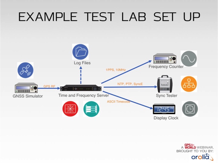
Test lab set-up. Photo: Orolia
In addition to increased jamming and spoofing threats, GPS has a “week rollover event” set to happen in April 2019. If the GPS receivers found at the heart of many critical systems do not handle this properly, any number of failures can occur.
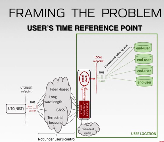
Without GPS timing, everything slows down, has less capacity and becomes more dangerous.
This Thursday, a complimentary webinar outlines test plans for GNSS equipment used in critical timing applications, discusses the need for assured access to accurate timing across financial institutions, industrial automation, telecommunications, transportation, the power grid and elsewhere — and defines just what “assured” access means and how crucial the “assured” part is — and finally reviews some recent mishaps and near-disasters caused by interrupted or inaccurate timing.
Speaking on the 1-hour webinar are Lisa Perdue, product manager and applications engineer, Orolia; Stefania Römisch, leader, the Atomic Standards Group at the National Institute of Standards and Technology; and Dana Goward, president, Resilient Navigation and Timing Foundation.
Following each speaker’s 12- to 15-minute slide presentation, a live Q&A period with the audience will explore particular issues and concerns.
A free lesson for those in charge of critical infrastructure systems such as the power grid, communications, financial markets, emergency services, and industrial control.
Many of these systems have functioned smoothly and efficiently for years, thanks to the precise timing provided by GPS receivers. That could change, suddenly and without warning, if predictive and preventative steps are not taken.
The GPS receivers somewhere near the hearts of these critical systems, if not thoroughly vetted, tested and checked for up-to-dateness, could constitute a vulnerability — a vulnerability that would be catastrophically exposed on April 6, 2019. In 6 months’ time.
Image: Orolia
The GPS constellation transmits the proper date and time to all receivers, worldwide, by supplying the current week and the current number of seconds into the week. This enables the receiver to translate the date and time into a more typical format: day, month, year, and time of day. Infrastructure systems use the precise timing to synchronize many complex operations across their respective networks. Critically, the field that contains the week number is a 10-bit binary number. This limits the range of the week number to 0 – 1023, or 1024 total weeks.
GPS week zero started January 6, 1980. The 1,024 weeks counter ran out and rolled over on August 21, 1999. The week counter then reset to zero, and it has been recounting ever since. The next time the counter will reach week 1,023 and roll over to zero is on April 6, 2019.
If the GPS receiver is new or has received firmware updates, it can accommodate and adjust for this change. But do you know for sure? Only if you test. Otherwise, your critical systems may go into a time warp, 19.7 years out of date. Visualize that discrepancy rippling outward from the core component of a critical timing system throughout your infrastructure. Or, simply not working at all.
It is incumbent upon all managers to verify that such an issue will not occur — well before its possibility arises. At a minimum, experts recommend consulting your receiver manufacturer to confirm that the issue has been fully tested and will not occur. Many manufacturers have already issued compliance statements, and are expected to continue doing so over the next year, up until the event occurs.
To be sure that your system will not experience any failures related to this issue, it is possible to test for this event using a GPS/GNSS simulator. The requirements for the simulator are straightforward. The basic yet key information necessary to undertake such testing will be communicated in a free webinar on Thursday, November 15.
The panel of expert speakers includes Lisa Perdue, product manager and applications engineer, Orolia; Stefania Römisch, leader, the Atomic Standards Group at the National Institute of Standards and Technology; and Dana Goward, president, Resilient Navigation and Timing Foundation.
You may register for this free webinar here, to attend it live or download it for later viewing at your convenience.
Here is a useful reference from the last time the rollover occurred, with a mention of the next one.
Photo: Technical University of Eindhoven
Eindhoven, the Netherlands, is home to the Eindhoven University of Technology, an incubator for technology startups where many scientists active in GPS research and in the direction of the Galileo satellite navigation program have trained.
Tectonics is the study of plates in the Earth’s crust that move in different directions and speeds. To study plate motion, GPS instruments are anchored firmly in bedrock to measure how it moves, infinitesimally yet measurably, thanks to the nanosecond timing provided by the GPS constellation and interpreted by properly calibrated and updated instruments.
A link to the live event will be sent to you two hours before the event. Your personalized event URL will be automatically generated by the ON24 system. To ensure receipt of the email, please whitelist this email address by adding it to your contacts: [email protected].
This presentation will begin on at 1 p.m. EST / 10 a.m. PST on Thursday, Nov. 15.
Audience members may arrive 15 minutes prior to live time. If you have any questions, please contact event producer Allison Barwacz at [email protected].
The UAV inspection industry continues to grow, as evidenced by these photos of actual end-user application. Unmanned systems follow precise flight paths to gather the data needed for inspection missions in the fields of insurance (home roof inspection), mining, construction and the pulp paper industry.
A free webinar on Thursday, Oct. 25 will show more of these applications and cover the requirements and challenges for positioning technology in commercial applications in urban and remote areas, including those generated by concerns about interference and spoofing.
Latest trends and challenges for drone-based aerial intelligence platforms for insurance and roofing applications
GNSS technology requirements for safe UAV BVLOS operations and a view of the regulatory frameworks
Importance of UAS traffic management systems (UTM)
Use cases in linear infrastructure inspection (railways, roads, power lines and others)
Challenges for GNSS systems in autonomous aerial vehicles and growing concerns about safety
Robustness of multi-GNSS receivers to jamming and spoofing
Latest innovation in GNSS technology concerning inspection applications and real-time accuracy/reliability
Earthworks contractors use this drone technology to perform detailed topographic surveys of project sites throughout all phases of construction. The new survey tool is reducing costs and time, allowing earthworks contractors to increase their profitability and ensure project success. (Photo: Paul Ross/Kespry)
In addition to a tailored application for roof inspections, targeted at insurance companies, UAV manufacturer Kespry provides a complete solution for construction and engineering companies to manage proposed and active earthwork operations. Without using multiple, cumbersome ground control points, survey-grade field data can be collected for an entire site in as little as 30 minutes.
In the webinar, attendees will learn how drone technology is being used to:
Validate proposed earthwork – reduce rework and extra earthmoving costs before the job begins
Safely measure earthwork activity – ensure subcontractor work and delivered material are constantly measured
Further application examples in construction projects will show how drones are providing construction companies with a new method for accurate survey work throughout their entire worksite that can:
Reduce up to 20 percent of total project costs by eliminating rework through regular cut and fill analysis of drone data
Eliminate up to 10 percent of earth moving costs through more accurate volumetric analysis
Perform more frequent surveys in-house with drones, reducing traditional survey equipment and service costs.
Kespry provides a complete solution for construction and engineering companies to better manage proposed and active earthwork operations. Without using multiple, cumbersome ground control points, survey-grade field data can be collected for an entire site in as little as 30 minutes. (Photo: Nathan Stump/Kespry)
In the first example show above, insurance claims for roof damage, the fully-autonomous system improves safety, reduces loss adjustment expenses, and delivers more accurate risk assessments, while reducing overall costs. For commercial property, the UAV solution helps prevent losses and informs underwriting decisions with high-resolution aerial and thermal imagery to identify exposures. Accurate, unbiased reports are easily prepared and shared with all parties. Mobile tools are provided to review inspection quality imagery within minutes of flight; artificial intelligence (AI) technology generates fully-dimensioned wireframes and 3D roof models
Drones for the pulp and paper industry
The drone and analytics platform enables companies to improve profitability through quick, cost-effective, and accurate surveying of chip and roundwood sites.
UAV applications in pulp and paper industry will be demo’d in the Oct 25 webinar (Photo: Jason Nichols/Kespry)
Kespry enables production plant and production managers to analyze stockpile inventories, better manage supply chain activity, and improve site operations — maximizing profitability across production and supply chain operations.
The company also supplies a drone-based AI platform for the aggregates and mining industry supplies accurate inventory management and mine planning. It will be demonstrated in the free October 25 webinar.
Galileo, BeiDou, QZSS, IRNSS, and more join GPS and GLONASS to bring you wider, broader, greater, more accessible and above all more accurate PNT. How to get all that’s coming at you?
Multi-GNSS paves the way for complete exploitation of new signals and constellations in navigation, surveying, geodesy and remote sensing.
The free 1-hour webinar, which will take place at 1 p.m. Eastern [10 a.m. Pacific, 7 p.m. (1900h) Central European Time] on Thursday, Sept. 20, will review advantages of using multi-GNSS for the end-user and challenges in obtaining maximum efficiency when combining multiple constellations and signals. It will also discuss different approaches of testing GNSS receivers against jamming and spoofing attacks.
You will learn:
Advantages of using multi-GNSS
Challenges when combining multiple constellations
Robustness of multi-GNSS receivers to jamming and spoofing
Test solutions for GNSS receivers.
The webinar presents sponsored content by Skydel and Talen-X. Register for it here.
The next generation of mobile network architectures promises increasing speeds and lower latency for the ever-expanding base of users and the constantly growing data volumes transmitted.
In order to deploy this next generation (5G), the network must be densified. Densification implies more cell sites in more locations and getting the signal closer to the users. This in turn places more stringent requirements on network synchronization to achieve these goals.
Network time and phase synchronization below 100 ns accuracy is critical for the low-latency requirements of 5G networks. As wireless carriers gear up for deployment, new digital GPS repeaters can ensure wireless networks are 5G-ready.
A free webinar this Thursday, Sept. 6, will review different methods of achieving frequency, phase and time synchronization in advanced communication networks, including 5G commercial wireless applications. Join two technical experts as they discuss the requirements for 4G and 5G network synchronization, the role of GPS/GNSS signals in synchronization and the different types of synch architectures.