Tag: Wi-Fi

  • Expert Advice: Exploring the Technologies Behind Location-Gate

    Feuerstein-200
    Marty Feuerstein

    By Marty Feuerstein

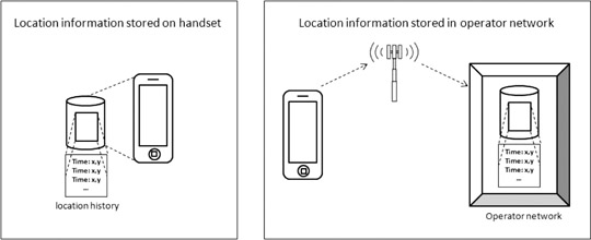
    For the past several months, controversy has raged over the revelation that Apple and Google tracked mobile subscriber location movements and stored that information in an unencrypted file on the handset, where it was potentially vulnerable to hacking and other inappropriate usage. The resulting Location-gate scandal highlights the sometimes tenuous control of mobile subscriber information versus the business objectives of dominant platform and applications providers. These business objectives may include immediate revenue opportunities from the subscriber being tracked or broader self-interest initiatives, such as collecting marketing data that may be valuable to third parties like advertisers, or building subscriber-reported Wi-Fi access point databases.

    Furthermore, while much has been written about the privacy impacts of the collection and use of consumer location information, few articles have clearly outlined the technologies behind Apple and Google’s tracking activities. It is important to fully explore and understand these technology methods, and how they differ from other location technologies in use, in order to properly evaluate the threat posed by Location-gate and to develop responses that maintain privacy while enabling the benefits of location-based services.

    Location, Tracking, and Storage

    iPhone and iPad subscribers had previously been aware that Apple tracked their location via GPS, because the company notified subscribers when an app required the use of GPS to identify location, and asked them to opt-in. However, soon after Location-gate erupted, Apple’s vice president of software technology, Bud Tribble, testified to Congress in May 2011 that Apple also had been tracking device locations over time using triangulation between nearby Wi-Fi access points and wireless base stations. Triangulation is the moderately accurate method in which the mobile device measures the nearby cell site or access point identifications and possibly signal strengths, typically pinpointing device location to within a few hundred meters.

    Following this revelation, Apple’s initial response was that “users are confused” and that it was simply “maintaining a database of Wi-Fi access points and cell towers around your current location…to help your iPhone rapidly and accurately calculate its location when requested.” Soon after Apple location tracking activity was revealed, it became known that Google was doing essentially the same thing, although to a slightly lesser degree (Android phones stored only the 50 most recent coordinate fixes and up to 200 Wi-Fi access-spot locations), and using a similar triangulation method without the subscriber’s explicit knowledge. Google Android devices also have GPS capability.

    Why, if both OS providers embedded or leveraged GPS in their phones, would they resort to a less accurate location method, triangulation?

    Neither company has provided an answer. We know that the triangulation method uses less battery power than GPS, conserving battery life for other uses while filling in performance holes for GPS in urban and indoor environments. Also, unlike with GPS, mobile subscribers are either not able to disable triangulation or must disable it separately. More relevant is the fact that triangulation allowed the OS providers to identify location automatically and track it over time in the background without the subscriber’s knowledge, for purposes such as building and maintaining a subscriber-reported database of Wi-Fi access points.

    From a privacy perspective, there is a dramatic difference between tracking someone’s location over time (the bread crumb trail that Apple and Google used), versus locating one’s position for a specific purpose and handling the location information only within the confines of a secure wireless network. Useful applications that are universally accepted, such as E911 for safety-of-life situations, employ the latter method.

    Other players in the mobile ecosystem, such as wireless network operators, have collected subscriber location information as well, but not by storing it in the device as historical files in the same way that Apple and Google did. Some information exists on the network side in association with billing records for calls (call detail records or CDRs), but this is not bread-crumb tracking of cell-IDs. E911 calls have records stored for use by public safety agencies, but most users never make an E911 call. Other messages containing coarse location may exist on a transitory basis (for example, location area updates), but these are not typically aggregated or stored for later processing.

    feurstein_figure-W
    Depictions of location information stored on handset and in operator network.

    Alternative Geo-Location Methods

    There exist location methods that provide far greater privacy and security than the location tracking and handset storage that Apple and Google have utilized. Standard methods exist for performing location using the wireless service provider’s network elements. These are called control-plane methods, which follow standards developed by 3rd Generation Partnership Project (3GPP) and 3GPP2. Other standard methods exist using IP transport from the client phone to a location server. These are called user-plane methods, such as the Secure User Plane Location (SUPL) standard from the Open Mobile Alliance (OMA). Both control- and user-plane location standards incorporate mechanisms for data security and user privacy. These standard control- and user-plane methods differ from the proprietary methods used by many client applications and OSs, which are inherently user-plane in nature but with non-standard implementations.

    Methods using a client application with handset-based location on the mobile device, also called user-plane methods, bypass the carrier’s wireless network elements and instead rely on an IP connection to transmit information from the client application to a server on the Internet. These user-plane location methods, such as client applications for handset-based A-GPS, as discussed, are already widely in use for location-based services. Handset applications are inherently vulnerable to hacking and privacy intrusions, as the recent spate of mobile viruses on Android has highlighted.

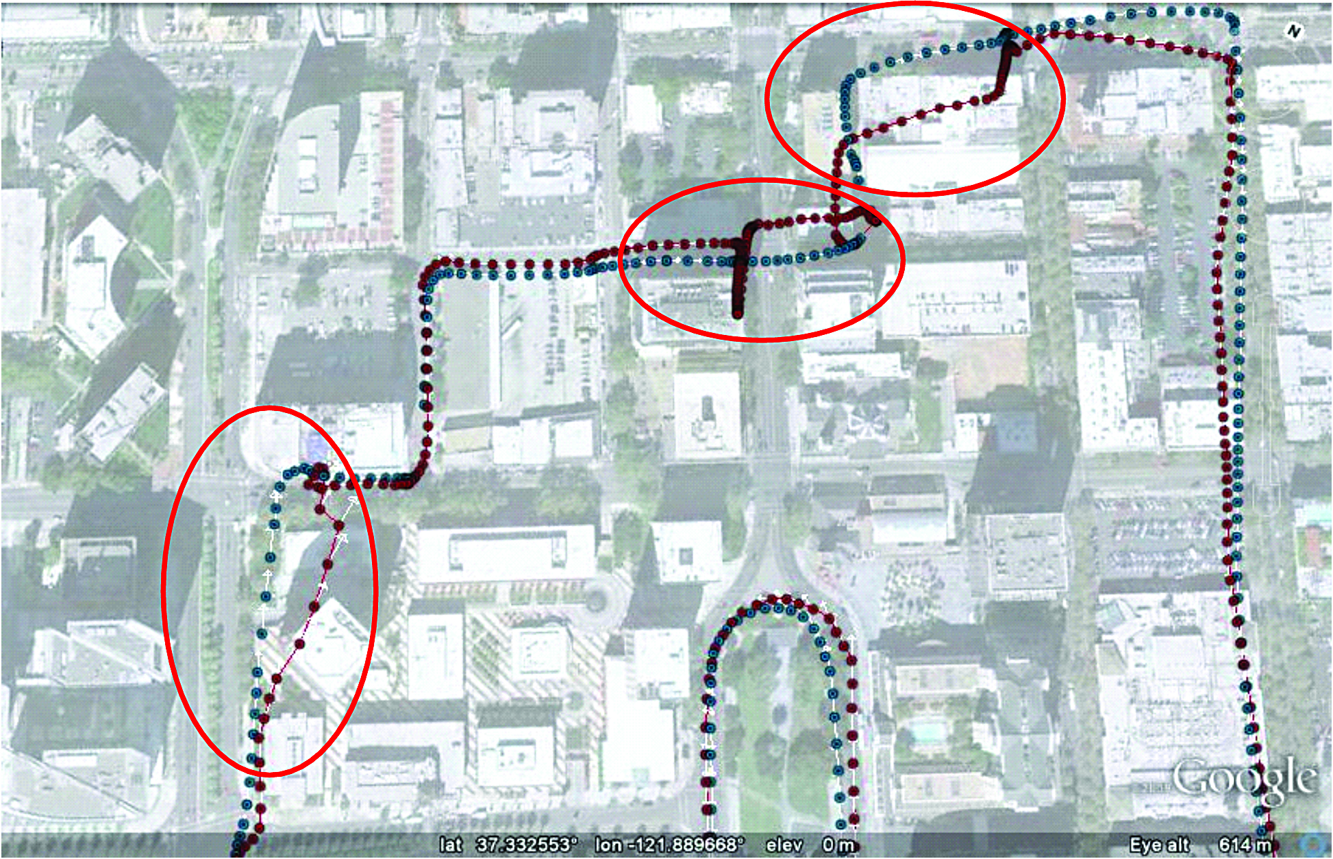
    A-GPS is highly accurate at identifying location in direct line-of-sight conditions with the satellites (open sky conditions), as found in suburban and rural areas, but performs less well in challenging dense urban and indoor environments. GPS in the phone can be easily disabled by the end user, and the receiver chip in the handset can cause significant battery consumption when used in demanding applications, such as navigation and monitoring geo-fences. A-GPS, as used by wireless network operators for navigation and other location-based services, does not usually store unencrypted files of historical location information in the handset, as Apple and Google did.

    Alternative, network-based, or control-plane, methods make use of the wireless services provider’s network elements to keep location information wholly behind the security of the operator’s firewall, employing highly standard protocols for security and privacy. Control plane location methods are used for today’s safety-of-life applications, like E911, where security and privacy are prime considerations.

    One example of a network-based location technology that can work in control-plane is RF pattern-matching (RFPM), which is the only high accuracy, software-based, scalable location solution that requires no additional hardware changes/additions to the mobile device or at the base stations. It compares mobile measurements (signal strengths, signal-to-interference ratios, time delays, and so on) against a geo-referenced database of the mobile operator’s radio environment. RFPM boasts a 100 percent security record for subscriber mobile location information it produces, for critical applications such as E911 emergency call and law enforcement location applications.

    Location information for growing consumer uses deserves the same privacy and security protections that other standards-compliant control-plane solutions provide for today’s mission-critical and safety-of-life location applications. RFPM works extremely well in non line-of-sight conditions such as dense urban and indoor environments, where GPS-based solutions face challenges. RFPM also offers low battery consumption and geo-fencing capabilities, which makes it ideal for providing location for the growing opportunity in location-based advertising and other location-based services (widely believed to be the true driver behind Apple and Google’s location tracking activities).

    As Location-gate clearly illustrates, there is no shortage of methods to identify and track one’s location via mobile device. Now that the issue has been raised, it is imperative that the entire mobile ecosystem — network operators, OS providers, regulators, and subscribers — clearly understand what methods are used, when one’s location is being identified and tracked, and what is being done with that data. Breadcrumb trails are useful if you’re trying to find your way out of the forest, but not if Big Brother is tracking you.


    Marty Feuerstein is chief technology officer of Polaris Wireless, where he leads research into new products, algorithms, system performance, and regulatory activities. He has a Ph.D. in electrical engineering from Virginia Tech.

  • Down and Deep

    More Satellites, More Sensors Take Urban Navigation Downtown and Deep Indoors

    By Frank van Diggelen

    As we all know, GPS is practically perfect in every way — as long as it’s outside and unobstructed. Even cell phones can now produce meter-level accuracy under open sky. There are still many deficiencies in state-of-the-art location, particularly in deep urban canyons and inside large buildings. Which technologies will lead personal navigation into the future?

    As we all know, GPS is practically perfect in every way . . . so long as it’s outside and unobstructed. Even cell phones can now produce meter-level accuracy under open sky. And, with Assisted GPS (A-GPS), those cell phones have mitigated the two great deficiencies of the original GPS: slow time to first fix (TTFF), and outdoor-only operation. A-GPS receivers can produce TTFF as fast as one second after a cold start, and (sometimes) work indoors.

    However, there are still many deficiencies in the state of the art of location, particularly in deep urban can yons and inside large buildings. In the latter you will soon notice that even if your A-GPS operates in your house, it does not operate everywhere. The term “indoor GPS” is rather like “off-road vehicle”: your four-wheel drive may let you cruise down the beach, but you certainly cannot use it to climb every mountain nor ford every stream. Similarly “indoor GPS” denotes the presence of a capability — not the absence of all limitations.

    And so what is the future of urban and indoor navigation, and which technologies will prevail? The short answer is: more satellites and more sensors. In this article we’ll look at the technologies that will move us from the era of GPS-only into the future of GPS-plus.

    Source: Frank van Diggelen
    This is Manhattan.
    Source: Frank van Diggelen
    This is Manhattan on Wi-Fi.

    Other GNSS

    The most likely addition to GPS will be the other global navigation satellite systems, and all GPS receivers will be replaced by true, multi-system, GNSS over the next two to three years. Not because this will ever fully solve indoor location, but because of the outdoor problem in deep urban canyons.

    When asked why he wanted to climb Everest, George Mallory famously said “because it is there.” Of the various GNSS systems, those with the most influence in the next few years will be GLONASS, because it is there, and QZSS because (as Mallory might have added) it is high. The first QZSS satellite recently began functional transmission. So let’s use QZSS as an example of why extra satellites are so important in the deep urban canyon.

    Figure 1 shows Shinjuku, Japan, a typical deep urban canyon and a terrible place for GPS. The blue dots show the positions of a GPS receiver. The white and orange lines show the actual line-of-sight vectors to the GPS satellites. The white lines are to GPS satellites in direct view. The orange lines are to satellites behind buildings. However, the high-sensitivity A-GPS receiver tracks all these satellites, by acquiring and tracking reflected signals. Thus the whole concept of GPS — of measuring distance by time-of-flight — breaks down. The reflected measurements are inaccurate because of the extra path length. And even if the receiver could somehow tell orange lines from white, the horizontal dilution of precision (HDOP) of the white-only lines is 58 in this real-life example. Now add two high-elevation satellites, shown by green lines, and things are much better. The green lines show the location of two QZSS satellites, and the HDOP of the five green + white satellites is 3.

    Figure 1 shows the problem of the deep urban canyon, and the value of extra satellites. The problem is that there are not enough satellites in direct view. This puts receiver designers in an insoluble dilemma: Track only strong satellites, and you will not have enough; or track weak satellites, and you will measure reflections with large measurement errors because of the extra path length of the reflection. Moreover, the reflected signals can be indistinguishable from direct signals in their characteristics, especially in mobile phones where the antennas are poor, and directional — so that signal strength is not a reliable indicator of whether a signal is direct or not.

    This example should put to rest the false notion that extra high satellites will not improve HDOP. In this case the HDOP improves by about 20 times, from 58 to 3. It is easy to find many similar examples using GPS + GLONASS or any other GNSS combination. More often than not, extra satellites improve the situation significantly.

    The QZSS system uses inclined geostationary orbits to provide high elevation coverage above Japan (and, as a by-product, neighboring regions.) In this respect it is unique amongst the major GNSS: it is exclusively designed to provide good urban coverage of its home region. Compass has a similar component, but ultimately it, like GPS, GLONASS, and Galileo, has global ambitions.

    Some other satellite systems, such as satellite radio, use inclined geostationary orbits like QZSS. With QZSS providing an alternative example of a new GNSS, European taxpayers might well ask why Galileo should provide medium-Earth orbit satellites that spend more time over America and Asia than over Europe. As a U.S. taxpayer, I’m all in favor of the current Galileo plan — after all, the United States has been sending GPS satellites over Europe for the last 30 years, so a little reciprocation seems only fair.

    Figures 2 and 3 show how the three satellites of QZSS provide better high-elevation coverage over Tokyo (and neighboring regions), than all of the 30 GPS satellites combined.

    QZSS-capable chips are already found in mobile phones and tablets available in the Asian market. As this article was being written, a Broadcom BCM4751 chip in Tokyo was computing the first-ever GPS+QZSS position.

    Source: Frank van Diggelen
    Figure 2. Elevation above horizon of the QZSS satellites, as seen from Tokyo. Note that the inclined-geostationary orbits of the QZSS system have been designed so that there is always one satellite above 70°.
    Source: Frank van Diggelen
    Figure 3. Elevation of GPS satellites as seen from Tokyo. About half the time none of the 30 GPS satellites is above 70° elevation, a quarter of the time one GPS satellite is above 70°, a quarter of the time two GPS satellites are, and for half an hour three GPS satellite are. The three satellites of the QZSS constellation provide better high-elevation coverage in Tokyo than the 30 GPS satellites.

    Wi-Fi

    After GNSS, the second-leading location technology is wireless local area networks, commonly known as Wi-Fi. Wi-Fi location works by using a database of media access control (MAC) addresses and locations. When a mobile device senses a Wi-Fi access point, the MAC address and database give the location of the access point (AP). A simple average of many APs gives position accurate to tens of meters.

    Wi-Fi location is already tightly integrated with GPS in many smartphones. Wi-Fi location accuracy is good enough that it is often mistaken for GPS, especially in cities where the density of APs is large. In Manhattan, for example, there are more than 25,000 APs per square kilometer (see opening figure.)

    Several major companies, including Apple, Broadcom, and Google, have worldwide databases of Wi-Fi AP

    locations that are used in mobile devices, especially smartphones and tablets.

    MEMS, Accelerometers, and Gyros

    The micro-electromechanical systems (MEMS) technique etches the silicon on a chip to exploit its mechanical and electrical properties. A MEMS chip, such as a chip-level accelerometer or rate gyro, thus has tiny moving parts that can sense acceleration or rate of turn, respectively. Both sensors are already common in smartphones, where they are used to set the correct screen orientation (portrait or landscape), and for gaming. Because they are already there, they are a natural addition to location technologies, and many companies are moving rapidly to integrate motion sensors with GPS for improved accuracy indoors and in urban canyons.

    As an example of the benefits of MEMS motion sensors, Figure 4 shows a test case where GPS was deliberately degraded by denying it the high direct-view satellites discussed earlier, and then adding nothing but low-cost MEMS sensors.

    Source: Frank van Diggelen
    Figure 4. GPS-only positions and GPS + MEMS. The red circles show where poor GPS-only performance was dramatically improved by the addition of low-cost MEMS accelerometers and rate-gyros such as those already found in certain smartphones and PNDs.

    Magnetic Compasses

    Like accelerometers and gyros, magnetic compasses are already found in many smartphones. The technology is rapidly evolving, and different techniques are used by different suppliers to determine magnetic north, including Hall effect sensors, fluxgate compasses, and MEMS. Performance is dramatically affected by nearby metal and severely affected by magnets. You may not think that you are surrounded by magnets, but you are — especially in your car where every speaker of your sound system is a magnet — and the better the speaker, the larger the magnet. Thus magnetic sensors alone are not a reliable location technology, but integrated with other sensors, such gyros or accelerometers, they can be and are very useful, especially for pedestrian applications.

    Altimeters

    Altimeters are another MEMS technology. Typically a hermetically sealed cavity on the chip is used to measure change in atmospheric pressure — the surface of the cavity is deformed as the outside pressure changes, and the deformation can be measured using piezoelectric strain gauges. The integration of altimeters with GPS is already well established for such applications as hiking receivers. Similar integration is likely in other consumer devices, especially smartphones.

    AFLT, MRL, and Cell-ID

    The three cellular-wireless technologies of AFLT, MRL, and Cell-ID are all components of A-GPS.

    AFLT (Advanced Forward Link Trilateration) is a technique used in CDMA phone systems, where the cell towers are precisely synced to GPS time. Because of this precise time synchronization, one can use the cellular signal to measure range from the cell tower, using time-delay just like GPS. CDMA phones with GPS are usually using AFLT when providing position indoors.

    MRL (Measured Results List), is the UMTS analogy of AFLT for non-synchronized systems. The MRL provides a list of neighboring cell towers and received power. Received power is used to estimate range, and from this, position. Accuracy is not nearly as good as AFLT, but can be decent, especially in cities where accuracy may be better than 100 meters, good enough for emergency location applications such as E-911.

    Cell-ID is simply the technique of looking up location in a cell ID database. This is analogous to Wi-Fi location, but not nearly as accurate since cell tower ranges are much greater than Wi-Fi. However, although perhaps the least exciting, this technique is the foundation of many important technologies. The AFLT and MRL techniques require Cell-ID as a necessary component. A-GPS usually uses Cell-ID for providing the assistance position, a necessary component of the high sensitivity that A-GPS provides. And Cell-ID alone is necessary for E-911 location, when A-GPS fails.

    Digital TV and Radio

    Location from digital TV works by measuring ranges from DTV towers, analogous to GPS and AFLT. However, DTV towers are not precisely synchronized to each other, and so DTV location requires the build out of fixed site infrastructure to deal with individual tower clock offsets.

    DTV location is in a way the opposite of Cell-ID. While Cell-ID is intellectually boring, the technique is practically very important and widely used. DTV, by contrast, is an exciting idea, because it can be accurate like GPS but with much more powerful signals. However, it has been a commercial failure.

    DTV location, or related technologies, may enjoy a resurgence in the future once mobile TV or digital radio (HD Radio and DAB — digital audio broadcasting) become more widely adopted.

    Pseudolites

    Well known to precison-location cognoscenti, pseudolites provide GPS-like signals from ground-based transmitters. They typically use a transmit frequency that is offset from GPS, but otherwise their signals are like GPS so that they can be used with a receiver with the same baseband as GPS.

    Pseudolites can be very accurate, as good as five centimeters when using carrier-phase measurements. They require local, fixed transmitters which are fairly sophisticated (since they must maintain time and phase coherency to work properly.) This makes them prohibitively expensive for widespread applications. However, pseudolites are highly valued and widely used in niche markets, and will probably remain so.

    IMES and Local Beacons

    IMES stands for indoor measurement system, and it, or something like it, could be the most interesting new location technology of all. IMES is a local-beacon system — it works by providing a very weak signal that is exactly like GPS, but is meant for data-transmission only, not ranging. Thus it is fundamentally different from pseudolites, which are designed for ranging. The power of each IMES transmitter is so low (0.1 to 0.4 nanowatts) that it can only be acquired within about 10 meters of the transmitter. The signal is modulated with a PRN code (PRN numbers 173 to 182) and data: the data contains the location of the transmitter. The system technology may be summarized as “if you can hear me, here you are.” And the accuracy is inherently about 10 meters.

    A fascinating detail of the IMES data message is that it contains (in message type 000): latitude, longitude and floor number.

    IMES is designed to work with any GPS receiver that can decode PRNs 173 through 182. And, because they are not intended for ranging, the transmitters do not have to be precisely synchronized with GPS or with each other. This makes them cheap to build and install. However, they do still need to be deployed in large numbers (at least one every 10 meters), and will require a government-sized effort to become reality. Interestingly, they might just get it: The IMES system is defined in an annex to the QZSS interface specification from JAXA, the Japan Aerospace Exploration Agency. But it is not clear how much funding is available for IMES, or if there is any mass deployment schedule.

    Even if IMES is never deployed, other, similar local-beacon systems may emerge. They will require a government-level (or similar) effort for the mass deployment required to make a system a reality for consumers.

    Thus IMES or similar local-beacon technology may amount to nothing, or it may be a complete game-changer, depending on how the game is played and how the cards fall.

    Summary

    We have seen that GPS is practically perfect, when outdoors. And because A-GPS has worked so well over the last decade, it has become the predominant location technology in consumer platforms such as smartphones and tablets. But, precisely because of this success, GPS is more challenged than ever as consumers expect it to work where it was never meant to: indoors, in deep urban canyons, and with very small, cheap, antennas.

    These challenges have led us to other technologies, in particular more satellites, sensors, and other wireless location techniques. The most prevalent and valuable additions to GPS in the next few years will be GLONASS and QZSS, as well as MEMS technologies, magnetic sensors, Wi-Fi, and cellular wireless technologies.

    Roughly speaking, the 1960s and ’70s were the decades of GPS conception, the 1980s the decade of development and delivery, and the 1990s the introduction to the world. Since 2000 we have had the decade of mass-market adoption, and the 2010s will be the decade of GPS-plus: other GNSS and other sensors.


    FRANK VAN DIGGELEN is senior technical director for GNSS, and chief navigation officer of Broadcom Corporation. He is the author of the bestselling textbook A-GPS: Assisted GPS, GNSS and SBAS, and holds more than 50 U.S. patents on A-GPS. He received his Ph.D. in electrical engineering from Cambridge University and is a consulting assistant professor at Stanford University.


  • AeroScout Debuts GPS/Wi-Fi Tracking at U.S. Air Base

    AeroScout Inc. has unveiled a combination GPS and Wi-Fi asset management system that has been selected by the U.S. Air Force 309th Aerospace Maintenance and Regeneration Group (AMARG) for its 110 million-square-foot outdoor facility at the Davis-Monthan Air Force Base in Arizona.

    The system includes battery-powered tags that use both GPS to determine location outdoors and Wi-Fi to transport asset location and other information over a customer’s network, according to AeroScout.

    The large-scale deployment will initially include 1,000 AeroScout GPS Wi-Fi tags for essential support equipment. The 309th AMARG stores thousands of aircraft and aircraft parts at the outdoor facility at Davis-Monthan outside Tucson, Arizona. In addition to tracking the precise location of essential support equipment, the AerosScout system will provide automated inventory reports, the company said.

    The system will leverage the facility’s existing Wi-Fi network and 42 access points with high-gain antennas, which are also used for data communication. Using AeroScout’s MobileView 4.0 software, staff will be able to search for, locate, and manage essential equipment, according to the company.