Tag: Wi-Fi

  • Broadcom Enables Pinpoint Indoor Location Technology with 5G Wi-Fi SoC

    Broadcom Corporation has announced the industry’s first 5G Wi-Fi (802.11ac) system-on-chip (SoC) to deliver pinpoint indoor positioning technology. The BCM43462 SoC, featuring Broadcom’s new AccuLocate technology, provides sub-meter accuracy on physical locations enabling retailers and public venue operators to deliver more personalized experiences to consumers.


    Broadcom will demonstrate its AccuLocate technology at Interop, Las Vegas, April 1 – 3, 2014, booth #1239.

    Analysts predict the indoor location market to reach $4 billion in 2018, fueled by increasing demand for location-based services in public venues such as shopping malls, department stores, airports and stadiums. By leveraging location-based services, retailers and venue operators can offer discounts, promotions and personalized services to consumers based on exact locations while enterprise network IT staff can use the technology to track and manage assets, Broadcom said.

    Broadcom’s latest 5G Wi-Fi SoC with on-chip AccuLocate technology operates using fine timing measurement (FTM) technology, resulting in highly accurate positioning regardless of environmental factors, Broadcom said. Previous versions of indoor positioning relied on received signal strength indicator (RSSI) technology, where signal strength and performance can vary depending on environmental factors such as crowd density or temperature.

    “Broadcom’s latest 5G Wi-Fi innovation with integrated AccuLocate technology delivers highly accurate sub-meter pinpoint technology that rivals the capabilities of outdoor location based technology,” said Ed Redmond, Broadcom vice president and general manager, Compute and Connectivity. “In addition to providing a more customized user experience, this technology has the added benefit of allowing venue operators to monetize their investment in existing Wi-Fi infrastructure.”

    “Location-based technology installations will break the 25,000 mark in 2014, while mobile devices capable of supporting indoor location will reach hundreds of millions within two years,” said Patrick Connolly, ABI Research senior analyst. “Rising demand for these services by the world’s leading venue operators and retailers is generating an immense opportunity for leading component suppliers, such as Broadcom, who are early to market with innovative solutions.”

    About 5G Wi-Fi

    Increased reliance on wireless networks, the explosion of video consumption and growing number of wireless devices are all putting tremendous stress on legacy 802.11a/b/g/n networks. With new innovations that allow for more reliable coverage, 5G Wi-Fi technology addresses these challenges, allowing mobile device users to stream digital content between devices faster, and simultaneously connect more wireless devices to home and enterprise networks, while conserving battery power.

    Key Features of the Broadcom BCM43462 SoC

    • Dual-band (2.4 GHz and 5 GHz) complete 5G WiFi (11ac) SoC with integrated MAC, PHY and radio
    • Three-stream spatial multiplexing up to 1.3 Gbps
    • State-of-the-art security provided by industry standardized system support
    • Embedded hardware acceleration enables increased system performance
    • Full IEEE 802.11a/b/g/n legacy compatibility with enhanced performance
    • Support for FASTPATH® UAP, Broadcom’s enterprise class access point software

    Availability

    Broadcom’s BCM43462 SoC with integrated AccuLocate technology is now sampling. AccuLocate technology is also available on Broadcom’s BCM43520 5G Wi-Fi 2X2 SoC, BCM43460 5G Wi-Fi 3X3 SoC and BCM4354 5G Wi-Fi 2×2 MIMO Combo Chip.

  • 2013: A Positive Year for Location Industry


    2013 was an up-and-down roller coaster of a year for the location industry…and 2014 appears to be more of the same. What was the big story? Google buying Waze? While it is easy to predict what will happen, the harder thing to do is to predict when it will happen. With that in mind, LBS Insider reached out to industry veterans to discuss the big buzz in 2013 in the industry — and what the future holds, next year and beyond.

    It’s that time of year — to assess the big deals and trends — good, bad and ugly — in the worldwide location industry. Some of the stories seem obvious, such as the Google acquisition of Waze for more than $1 billion.

    “The valuation remains a mystery to many in the mapping community, but it is always nice to see a truly great exit in this business.  There haven’t been enough for an industry that is both foundational in mobile and online, and really hard to do well,” said Marc Prioleau, president of Prioleau Advisors.

    Prioleau says one of the big stories of 2013 was the reemergence of Apple Maps.  “For all the flak they took, they’ve worked hard to make them better.  Their default position in iOS has given them traffic, as has the extension to OSX in the Maverick’s release,” he said.  “Last year you saw Apple start to buy companies that could extend the features (like HopStop), a sign that they think they’ve fixed the major problems and are working on moving forward. They are also hiring aggressively and have brought in some very good people.”

    Last year, Prioleau predicted that the combination of data with location to derive better location-based context would be a big thing.  “I think a lot has happened in that area with much more to come.  It’s happening in apps (see Foursquare recommendations), advertising (PlaceIQ and others), CRM (SAP Precision retailing as an example),” he said. “There is a lot more to come here, and we should expect many new applications, most of which will do things badly, but some — likely the ones with the most targeted data — will do things that really change the model.”

    Prioleau says MapBox is making mapping cool again (and Prioleau is a director at the company).  “Just when all was going to be subsumed by the Google Maps juggernaut, MapBox is doing new interesting data visualization work,” he said.

    Crowdsourcing being embraced by the wider mapping community is another big trend Prioleau has identified.  “Everyone knows about OSm, but then you add Waze for crowdsourcing real-time traffic plus map corrections. Google is in deep with MapMaker, and even Nokia is pushing crowdsourced input,” he said.  “It’s no longer the battle between crowdsourced maps and professional maps. It’s how to make the two work together.”

    Prioleau sees the location industry having a few benchmarks in 2014.  “I’ll stick with the same prediction as last year:  Data + location for better location context. Google Now is a great benchmark,” he said. “Break out in location-based ad targeting. The technology is better, and the providers really understand the advertising market now. Complementary ad technologies like Real Time Bidding are maturing, and these will fit in to a model that really works. And if for no other reason, if we keep predicting it, it will be right one year, right?”

    Prioleau believes Google Map domination will begin to show cracks. “Google has a great platform, but as they monetize it more aggressively, more companies will look for alternatives,” he said. “Apple maps will be one. HERE will be another. But solutions from MapBox and others will grow as well.”

    In terms of connected car and other automotive technology, Prioleau says new and interesting applications will come from local search, driver services, and diagnostics — rather than just basic navigation.

    Another industry insider, Mike Dobson, president of TeleMapis, said 2013 was a quiet year for location-based services.  “Even the biggest deal, Google’s acquisition of Waze, does not look as if it will have much impact, other than as a defensive strategy. Perhaps the most interesting aspect of the year was the stream of patents covering LBS and GIS-like applications from both Apple and Google, not to mention those of several start-ups,” he said.

    From his perspective, Dobson said 2013 was yet another year in waiting, but 2014 looks like it might actually be exciting. “It appears that Google will finally make its move into the in-car navigation market. Apple is beginning to play with the idea of allowing its users access to a more GIS-like parsing of its map database,” he said. “Perhaps the biggest change will be a new focus on thematic maps that aim not to be navigation aids, but to perform the function of information devices for travelers and others using directed search technology. I suspect that 2014 will be another slow year for indoor positioning, but maybe it will flourish as a subset of BIM.”

    Indoor Mapping Still Considered Trend for Location Industry

    While many in the location industry have seen new companies and products coming to the indoor positioning market, at least one analyst says that Wi-Fi positioning has been weak.

    “The biggest trend in 2013 was indoor mapping, the beginning of the hockey stick adoption curve in my opinion. Major retailers like Home Depot, Lowes, etc., launched indoor maps with product search/locator,” said industry veteran Kris Kolodziej. “What was overblown was indoor Wi-Fi positioning. The latency and accuracy is not good enough for micro location. It’s good enough to know what store/venue you’re in, but that’s about it.”

    Kolodziej said that the big deal in 2014 will be ibeacons or Bluetooth low energy (BLE) for micro location and proximity services. “BLE solves the many shortcomings Wi-Fi has,” he said.

    Prioleau says that in-door location will be big, but it is where outdoor location was in the early 1990s:  many technologies and technology providers all pushing different solutions — and most will not succeed.

    “Beyond the location technology, the market needs to figure out how the money will flow from beneficiaries of the market (retailers, brands) to the providers of indoor location technology (mostly semiconductor companies and tech companies).  There is no natural connection,” he said.

  • NextNav and Broadcom Partner for Indoor Accuracy

    NextNav and Broadcom Partner for Indoor Accuracy

    A NextNav beacon.
    A NextNav beacon.

    On October 2, NextNav announced that Broadcom Corporation acquired a commercial license to NextNav’s Metropolitan Beacon System (MBS) technology, a so-called terrestrial constellation that brings GNSS-like performance to indoor and urban environments where satellite-based positioning is either unavailable or significantly degraded.

    The agreement enables Broadcom to integrate NextNav’s location technology into its mass-market GNSS connectivity and mobility platforms, used primarily in cell phones and tablets.

    NextNav President and Founder Ganesh Pattabiraman characterized the deal in a conversation with GPS World:  “This is a commercial license to a Tier 1 chipset provider, whose products are in a vast number of smart and feature phones in the country. The partnership enables our technology in a low-cost, high-volume form factor. This is important for us since we don’t make chips. We rely on partners such as Broadcom.  This is the first of many such agreements; we’ll have more through the year.”

    Most wireless companies have a mobility group addressing cellular modems, the central clearinghouse for so-called connectivity: the combination of Wi-Fi, Bluetooth, GNSS, and other technologies. Standard assisted GNSS (A-GNSS) packages to date in such cases generally consist of  ephemeris from all GNSS satellite constellations supported by the wireless company’s chips, cell ID and Wi-Fi ID from base-station databases, and additional proprietary assistance mechanisms.

    The NextNav MBS concept shares many operating principles with GNSS satellite constellations, but because the NextNav beacons are installed terrestrially instead of in space, they transmit sufficient signal strength for reliable reception indoors and in urban canyons where a clear view of the sky is unavailable. MBS is deployed much like a cellular network, to provide consistent indoor positioning to every building within a covered metropolitan area. MBS offers both accurate horizontal positioning and highly accurate altitude information, a particularly important capability for emergency responders in urban and indoor areas where GNSS systems tend to be most challenged.

    NextNav built its MBS network across forty large U.S. markets (see list at end of story) with its own Federal Communications Commission (FCC) licensed spectrum. “We bring more a managed network providing consistency and reliability of position information,” continued Pattabiraman. “Also the vertical component that other systems do not provide.” He characterized Wi-Fi, for example, as “an unmanaged network,” subject to frequent changes without a centralized and continually updated source of certified data.

    NextNav location performance was recently highlighted in side-by-side technology tests conducted by the Communications Security, Reliability, and Interoperability Council (CSRIC) of the FCC, and published in March of this year; see reportage and analysis of these tests at The Inner Edge: Who Holds the Key to Indoor Nav?

    The trial compared the performance of location systems across urban, suburban, and rural areas in the San Francisco Bay Area for determining the location of callers during emergency calls (E911), a critical case for mobile-phone users. NextNav was the only technology capable of reporting a valid height or altitude estimate, enabling floor-level positioning. NextNav’s horizontal accuracy results also reduced first-responder “search rings” by 90 percent over its nearest competitor.

    Don Fuchs, director of business development at Broadcom, added “Nextnav is a metropolitan area location system, which is typically a wider area than that covered by Wi-Fi. Wireless emergency assistance calling (E911) needs a wider venue covered. And across 40 metro areas. Nextnav is wide area, while Wi-Fi is essentially local area.”

    Pattabiraman said that in a typical metro area, NextNav’s terrestrial constellation of beacons is deployed for maximum coverage and minimum GDOP, and is not constrained by capacity like a cellular network. He stated that the San Francisco Bay area covered by NextNav extends to 900 square miles, from South San Jose into Marin County and East Bay. “With a fraction of the beacons required for cellular coverage in the same area, which would be in the neighborhood of a few thousand antenna installations, our deploy and operating costs are much less. Less than 20 percent of that for a cellular network.”

    In comparison with Locata, another recently rolled out terrestrial constellation designed to fill GNSS gaps, Pattabiraman said,Locata and NextNav are two entirely different systems serving different needs.  We are in the mass-market commercial cell phone wide area use case, filing that gap, providing 5–10 meter accuracy, with vertical as a critical component, and full market coverage. Locata covers centimeter-level precision application in localized environments. The two companies could both eventually get to the other side [of the market-sector spectrum], but currently each of us is focused on the particular requirements of our designated market areas. Also, we operate with licensed spectrum versus the Locata operation in 2.4 GHz unlicensed.”

    “At the highest level, they are both multi-lateration systems.  Time of arrival, time difference of arrival.  We arrive at our core synchronization via GPS, which has its own synchronization, but we’ve got our IP  on top of that to improve it.  Each beacon is autonomous.  You can drop it anywhere with a clear view of the sky, and it is synchronized to the rest of the network, it has its own self-synchronizing mechanisms.  Locata is a synchronized network.

    “Another way of looking at it, they have a replacement for GPS. We do more complementing for GPS, we count on GPS being there.”

    Broadcom’s Fuchs added, “From the perspective of a company designing GPS and GNSS client-side semiconductors, we view NextNav as a terrestrial constellation, no more difficult or challenging than adding support for any new or legacy constellation like BeiDou or GLONASS.  We see this integration as being very straightforward, we have lots of IP in the area of signal processing, these sort of signals, this sort of positioning algorithm. We add NextNav as a secondary technology for challenging urban conditions. We view this as a piece of location technology to develop and integrate as the market demands.

    “In six years at Broadcom and seven before that at Global Locate (acquired by Broadcom in 2007), we have a history of turning support like this, we’ve been able to do this very quickly.  Depending on market demand, in less than a year.  I can’t lay out a roadmap at this point.  We expect to see market demand for this, certainly expect regulatory demand.  We wanted to get to the point where we can react to that in less than a year. That was the motivation to get this agreement into place, and we are now positioned.”

    “We all operate under standard operating environments as specified by the FCC. We’re metro-wide just like paging towers or broadcast TV,” continued Pattabiraman. “We’re not necessarily doing anything different as regards the indoor environment.  We’re not adding anything additional to the noise spectrum or floors. Our maximum transmission is 30 watts, very small compared to cell transmission in kilowatts. It is bits per second by the time it hits the receiver.  Because it’s calibration for navigation, the network design is optimized for location. We take into account GDOP and coverage, maximizing the latter, minimize the former. There is a very low throughput. It’s a tradeoff between power and coding.  We code the heck out of this thing.  We just new a few bits to get our information through, not like cellular that needs to get megabits through.”

    As to any data or issues about the human health impacts of an RF-rich indoor environment, Pattabiraman concluded, “There’s none of this concern about power into your head. We transmit only at the tower, receive only at the user. It is very, very heavily coded, like GPS, and very low-powered.  It’s not even close [to cell transmission power].  We’re a feather, they’re a hammer.”

    List of NextNav Covered Metro Areas

    NextNav characterizes San Francisco as built to “commercial grade” and the other markets as “Initial Builds.”

    • Boston-Worcester-Lawrence, ME
    • Syracuse, NY-PA
    • New York-North New Jersey, NY-NJ
    • Philadelphia-Wilmington-Atlantic City, PA-NJ-DE-MD
    • Washington-Baltimore, DC-MD
    • Greensboro-Winston-Salem-High Point, NC-VA
    • Raleigh-Durham-Chapel Hill, NC
    • Jacksonville, FL-GA
    • Charlotte-Gastonia-Rock Hill, SC
    • Orlando, FL
    • Miami-Fort Lauderdale, FL
    • Tampa-St. Petersburg-Clearwater, FL
    • Atlanta, GA-AL-NC
    • Cincinnati-Hamilton, OH-KY-IN
    • Columbus, OH
    • Pittsburgh, PA-WV
    • Cleveland-Akron, OH-PA
    • Detroit-Ann Arbor-Flint, MI
    • Grand Rapids-Muskegon-Holland, MI
    • Milwaukee-Racine, WI
    • Chicago-Gary-Kenosha, IL-IN-WI
    • Indianapolis, IN-IL
    • Nashville, TN-KY
    • Memphis, TN-AR-MS-KY
    • New Orleans, LA-MS
    • St. Louis, MO-IL
    • Kansas City, MO-KS
    • Oklahoma City, OK
    • Dallas-Fort Worth, TX-AR-OK
    • Houston-Galveston-Brazoria, TX
    • San Antonio, TX
    • Denver-Boulder-Greeley, CO-KS-NE
    • Salt Lake City-Ogden, UT-ID
    • Las Vegas, NV-AZ-UT
    • Phoenix-Mesa, AZ-NM
    • Los Angeles-Riverside-Orange County, CA-AZ
    • San Diego, CA
    • San Francisco-Oakland-San Jose, CA
    • Portland-Salem, OR-WA
    • Seattle-Tacoma-Bremerton, WA


  • eTrak Launches GPS+ Line with Verizon-Powered Tracking System

    eTrak Launches GPS+ Line with Verizon-Powered Tracking System

    eTrak-opener
    eTrak

    eTrak has released its GPS+ line of consumer and commercial tracking products. GPS+ is eTrak’s patent-pending technology that integrates Wi-Fi, cellular triangulation and GPS to achieve the most accurate positioning possible, both indoors and out, eTrak said.

    GPS+ delivers accurate location in real time directly to a smartphone, tablet or computer. eTrak products also contain geofencing capability, which triggers notifications if the device goes beyond preset boundaries. Additionally, the notifications provide a map and address with the location of the device.

    “Small and large businesses will benefit from tracking their assets with loss prevention and cost savings,” said eTrak CEO, John Harris. “They will also be able to keep their employees safe and know if they are in danger or need assistance.”
    ETRAK CORP. GPS

    Set-up and the use of eTrak products is simple, the company said. Users can go to eTrak.com and start tracking from any smartphone, tablet or computer and instantly see the location of the eTrak device. The eTrak consumer device is also equipped with an emergency panic button that sends help requests to predetermined recipients in the event of an emergency.

    “eTrak is the size of a domino and weighs less than an ounce,” Harris said. “eTrak provides the longest battery life available, and is a low cost personal emergency-response product. And with Verizon’s industry-leading coverage map, it works almost anywhere.”

    The eTrak product line encompasses commercial applications, as well as consumer segments including health-impaired, special needs, teens and pets. eTrak also supplies custom design and development services.

  • Apple Buys Indoor Location Company WiFiSLAM

    The Wall Street Journal is reporting that Apple has acquired indoor-location company WiFiSLAM. Apple reportedly paid about $20 million for the Silicon Valley-based company. Apple has confirmed the purchase to MacRumors, but offered no details on its plans for the acquisition.

    Analysts say this is a sign that the war over indoor mobile location services is heating up.

    Apple’s acquisition of WiFiSLAM illustrates how 2013 will be a breakout year for indoor location as initial trials shift to technology deployments, application development, and revenues, according to ABI Research.

    Two-year-old start-up WiFiSLAM has developed ways for mobile apps to detect a phone user’s location in a building using Wi-Fi signals, according to the Wall Street Journal. It has been offering the technology to application developers for indoor mapping and new types of retail and social networking apps. The company has only a few employees. Co-founders include former Google software engineering intern Joseph Huang.

    “The move comes as Apple continues to build its arsenal against Google in mapping,” according to Wall Street Journal blogger Jessica E. Lessin. “It debuted its own mapping service last year to poor reviews and user complaints about inaccurate data. Apple chief executive Tim Cook apologized for the quality of the product, and Apple has continued to improve it.

    “Google already offers indoor mapping in certain locations like airports, shopping centers and sports venues,” Lessin said.

    ABI Research’s latest report “Indoor Location in Retail: Where Is the Money?” provides an overview of all major technologies, revenue opportunities and competitive environment. “Analyzing across 10 retail sectors, we are seeing a lot of cross pollination as companies combine handset and infrastructure based Wi-Fi, Bluetooth, and sensor location technologies. The emergence of public venue small cells and carrier Wi-Fi will also create a new wave of opportunity,” commented Patrick Connolly, senior analyst. “As a result, we expect to see a flurry of acquisitions and partnerships in 2013, as major players start to make their moves.”

    In support of these technologies, ABI Research is also forecasting smartphone retail apps to break 1 billion downloads, while indoor maps will break 1 million buildings, over the forecast period.

  • Cambridge Consultants Unveils Indoor Locator System

    Cambridge Consultants Unveils Indoor Locator System

    Tracking_O

    New technology from product development firm Cambridge Consultants can accurately detect someone’s location indoors when GPS drops out. A number of sensors and a custom algorithm determine the location, with an accuracy of within approximately 1 percent of the distance traveled.

    Close_up-WThe technology uses low-power, low-cost sensors and the device concept is small enough to clip on a belt. It also doesn’t need any existing internal infrastructure.

    “We are excited about the many possibilities this cutting-edge technology opens up and the impact it can have in many different situations,” said Geoff Smithson, technology director, sensing systems, at Cambridge Consultants. “It could be used to help locate firefighters in smoke-filled buildings, for example, or to pinpoint the closest doctor in a hospital during an emergency — or to track offenders during home curfews. We are just starting to see the potential of this approach and the diverse demand for this type of low-energy, highly accurate system.”

    Indoor tracking systems, which process data from one or more sources of location information to estimate where a person or object is located, are not new. But they often rely on RF signals from Wi-Fi access points or custom infrastructure, poor-quality GPS signals or expensive, high-quality sensors. The availability of low-cost smartphone components — including accelerometers, gyroscopes, magnetometers and pressure sensors — has enabled a new generation of location devices and applications, when combined with a tailored Bayesian algorithm to fuse the information.

    Handset-WThe new technology platform can be embedded in an existing design or operate as a stand-alone unit, with options to compute the location locally or transmit the information to a remote system that can process the data before visualizing it on a smartphone app.

    “Our biggest challenges were developing an algorithm which optimally combines the data from GPS and the other sensors, and overcoming the issues of using such low-cost sensors in a system without any absolute location reference,” said Smithson.

    Cambridge Consultants specializes in developing low-cost, low-power connected devices for clients with a team of experts with sensing, wireless and software  engineering expertise. The latest technology builds on the company’s tracking and location systems experience in a variety of market sectors ranging from defense and security to consumer, industrial, and oil and gas.

  • Ruckus Wireless Offers Wi-Fi Solutions for Rising Data Demands

    Ruckus Wireless, Inc. today outlined its SmartCell architecture for creating carrier class Wi-Fi networks to deal with the densification challenge sweeping the industry. Built on its SmartCell Architecture, Ruckus unveiled a wide range of new carrier-class Smart Wi-Fi products, including the Ruckus ZoneFlex 7782 family, which integrates a GPS receiver. The announcement came at the Mobile World Congress being held in Barcelona, Spain, this week.

    The rapid growth of mobile data services, driven by smartphones, laptops, and tablets has accelerated data-traffic growth to the point where macro cellular networks are no longer sufficient to meet subscriber demand in many high-density indoor and outdoor settings. While new macro cellular technology, such as long-term evolution (LTE), is being introduced to address this capacity crunch, it will provide only partial relief, as traffic volumes continue to grow faster than operators can economically add capacity, Ruckus said.

    Consequently, mobile operators are rapidly adopting Wi-Fi as an additional radio access network (RAN) option to augment mobile capacity. At the same time, fixed line carriers and multiple system operators (MSOs) are also deploying Wi-Fi for public access to enhance their service offerings, reduce subscriber churn and enter new markets such as managed enterprise wireless LAN (WLAN) services.

    For high-capacity outdoor environments, such as stadiums and other public venues, the Ruckus ZoneFlex 7782 outdoor AP Series is a family of four new, high-capacity Wi-Fi access points designed to give service providers unprecedented capacity and performance. With models supporting omni-directional antennas, 120º sectorized, and 30×30º narrow-beam coverage through integrated internal antennas as well as external antenna options, ZoneFlex 7782 APs offer a combination of high performance and flexibility in a sleek, low profile, light form factor essential for meeting the tight mechanical and aesthetic constraints of deployment outdoors, Ruckus said.

    Each Ruckus ZoneFlex 7982 AP is a dual-band, three stream (3×3:3) 802.11n access point enabled for high throughput approaching 900 Mbps. ZoneFlex 7782 APs with integrated antennas support Ruckus-patented BeamFlex adaptive antenna technology for greater signal gain and interference mitigation. Additionally, the Ruckus ZoneFlex 7782 family integrates a GPS receiver, allowing service providers to begin providing location-based services as well as continuous spectrum monitoring features.

  • Will Fragmentation Hurt Location Business?

    Get out of the way, GPS. Wi-Fi is elbowing in on the location game. Wi-Fi operators are tracking people and offering retailers and marketers access to customers’ behavior and location. Traffic patterns emitted by smartphone Wi-Fi signals let network operators keep tabs on what shoppers are doing. Heat maps are being created with data from Wi-Fi points to map out aggregated customer behavior. Nearbuy Systems offers stores software that will let them track the website that a shopper is viewing, overlaid by where the shopper is within the store. However, beware of companies’ hyped up claims on indoor location. Another worry is the deployment of proprietary location systems which reduce overall usefulness. And some offerings are simply PowerPoint aspirations. In other news, Apple and Google are kings of the hill; in-vehicle mapping belongs to Nokia; and location privacy of a different sort.

    Fragmented Indoor Location. If proprietary indoor location systems are developed, the market will be hampered. Ben Rodilitz of Level8 noted that, while attending GPS Wireless last March, he was bemused by the excitement regarding indoor location as manifested in a number of one-off, proprietary systems. If Home Depot used its own system, an airport used another, and a shopping mall implemented a third, ubiquitous indoor location would be problematic. “I know companies like Qualcomm, Broadcom, and SiRF/CSR were building competing platforms; one would hope this is a vehicle for best-of-breed choices for service providers,” says Rodilitz. I am glad to see the formation of the In-Location Alliance and the players who are supporting it.”

    Other Complications. The nuts and bolts of indoor location aren’t easy peasy. “For detailed location pinpointing in places like malls, a high density of Wi-Fi radios need to be deployed and it isn’t super cheap to do so,” says Joseph DeStasio of Boingo Wireless. Stores may want to deploy a denser Wi-Fi system than in the outer mall. But it can be a clunky transition between two different Wi-Fi systems. DeStasio estimates that true mobile retail location-based advertising/couponing at malls is still 18 months away.

    Mapping in Vehicles. Nokia may be battered, but the mapping it acquired years ago from its acquisition of Navteq is shining bright. Companies have long fought over “ownership” of the in-dash navigation market, and Navteq lords over the market, powering four out of five systems. Nokia has deals with many car makers, including BMW, Hyundai, Mercedes, and Volkswagen, as well as with Pioneer and Garmin.

    Wireless Data Privacy and Mooching. There is always an interesting mobile location privacy case. In Pennsylvania, police obtained a warrant to search the house where child pornography was being downloaded. Police determined that the offender was a neighbor who had been free-loading on the house’s wireless Internet. The suspect was found with Moocherhunter, an app to identify wireless moochers. The suspect argued that police needed a warrant to use the app to locate him. The court ruled that he “could have no reasonable expectation of privacy in the signal he was sending to or receiving” from the wireless router.

    More on Wi-Fi. Towerstream is building wholesale Wi-Fi access points across some urban regions, including Manhattan, with 1,000 access spots arranged in a giant dense honeycomb across the Big Apple. Before you equate this with previous municipal wireless disasters, know that these networks are several times fasters and don’t involve local government.

    Towerstream is granting users four hours use with no charge if the user will interact with a location specific advertisement. These deals may be targeted to within dozens of feet of the user. Since service over Wi-Fi doesn’t count against U.S. mobile data limits, usage is particularly appealing to 18-34 year olds, who may be wallet constrained and open to viewing location-based ads in exchange for streaming video at high speeds.

    Oligopoly! Google’s Android and Apple’s iOS continue to wipe the floor with their competition. Together they controlled 87.9 percent of the U.S. smartphone market in October, according to comScore. Android ended October with 53.6 percent nationwide smartphone share, increasing 1.4 percentage points over July. iOS grew its U.S. market share from 33.4 percent in July to 34.3 percent in October, a 0.9 percent improvement.

    Tweet This. Use of social media and social networking is growing rapidly. Consumers continue to spend more time on social networks than on any other category of site—roughly 30 percent of total time online via mobile, reports Nielsen and NM Incite. Facebook remains the top social network, followed by Twitter and Blogger, but new social media sites continue to emerge.

    Foursquare Wants Money. The tepid, if not poor, performances of social media IPOs has made investors skittish. The fates of Facebook, Zynga and GroupOn stocks have weighed heavily on this category. Foursquare, which pioneered location check-ins and is now succeeding with target location couponing, is having difficulty attracting added investment, reports the Wall Street Journal. Foursquare counts more than 25 million registered users, with only about 8 million accessing the app monthly. Some investors believe the company is moving too slowly to monetize.

  • A Look at Small Indoor Location Competitors

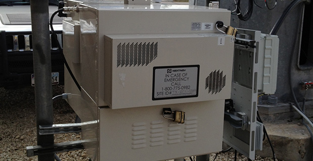
    Everyone wants a piece of the pie, the upcoming indoor location pie. Big companies and start-ups are engaged, some in research, others having launched solutions. While Wi-Fi is the most common technology, many companies are pursuing alternate methods, including GPS, audio, Bluetooth, small cell/cellular, distributed antenna systems (DAS), near field communication (NFC), white band, sensors, movement tracking, beacons, and more. Of the large players who are making a play for the indoor market, Cisco, Google, Microsoft, Motorola, Nokia, Qualcomm, RIM, and TCS are the furthest along, reports Grizzly Analytics.

    At a minimum, indoor technology will do what we do outside and enable GPS-style mapping, navigation, local search, check-ins, location-sharing, and other location-based services. An explosion of other uses will evolve, enabling search for items on store shelves, sending deals, and contextual advertising.  This newsletter issue is devoted to looking at smaller companies, those not listed above, many start-ups competing for their piece of the pie.

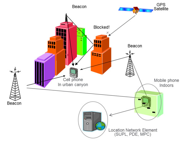
    A pool of smaller indoor companies is focused on creating positioning technology, many ripe for acquisition. Navizon, sensewhere, and SkyHook are betting on unique approaches to determining indoor location position. No longer solely focused on driving the streets to map Wi-Fi signals, Skyhook has adopted a comprehensive approach to indoor location, integrating multiple technologies (GPS, Wi-Fi, cell, and sensor-based) to ascertain location, a solution that offers the advantage of flexibility. Navizon is focused on Wi-Fi signals, currently the most popular solution for indoor location. There are sometimes existing Wi-Fi nodes, but added nodes can usually be fairly easy to install. From a business standpoint, the downside of Wi-Fi positioning is the large number of competitors focused on solutions. sensewhere is pursuing an entirely crowd-based software offering  that locates and cross-references publically broadcast information, including MAC addresses, from consumer devices. It is the easiest solution. No infrastructure is required, but it requires a certain density of devices.

    I’ve asked Navizon, sensewhere, and Skyhook to write, in their words, about their company, technology and perspective on the industry:

    Navizon In Their Own Words. “Navizon Indoor Triangulation System (I.T.S.) uses Wi-Fi signals to provide indoor location throughout a building or campus. Navizon designed this system to locate users of smartphones, tablets and laptops, all of whom rely heavily on Wi-Fi.  This real-time locating system’s infrastructure uses small, easily deployable nodes connected through a mesh network.  No wiring or software installation, and only minimal configuration, are required. The administration dashboard is an online interface to Navizon’s cloud.  Integration is through a web services API.  This design delivers an affordable indoor location platform, with room and floor-level accuracy, up and running in a single day.” Cyril Houri, Navizon

    sensewhere In Their Own Words. “sensewhere technology automatically locates and cross-references RF access points via user devices to create an almost limitless proprietary, reliable, live, global RF location database. The solution does not require additional infrastructure installation nor calibration or re-calibration when the venue’s RF infrastructure changes. sensewhere technology is powered by patented algorithms that dynamically adapt to indoor environments to optimize the use of mobile device resources. Commercial benefits have been demonstrated in the largest shopping malls around the world where more than half of RF infrastructure can change within a few months.” Rob Palfreyman, sensewhere

    SkyHook In Their Own Words. “Location technology company Skyhook, provides seamless operation of indoor and outdoor mobile device positioning using integrated GPS, Wi-Fi, cell, and sensor-based positioning technologies. Venues have been hesitant to get involved with indoor location due to concerns over control of their data, cost of initial deployment, cost of maintenance, accuracy and consistency of the technology, and availability to deploy on a large variety of devices.  Skyhook is involved in industry efforts to provide venue owners the ability to manage their infrastructure data in a consistent, standardized way that addresses both the technical and business needs.” Ronda Billings, Skyhook

    Positioning technology is of limited use without indoor venue maps, which might include shopping malls, arenas, convention centers, and hospitals. Retail is very interested in being able to direct people into their stores, to a particular aisle, or even shelf location. Meridian, Micello, and Point Inside have distinct approaches. Micello creates indoor maps by using data found in public domain; their customers are not the venues, but the developer community. Meridian creates indoor maps based on maps drawn  by customers and adds navigation and points of interest. At its start, Point Inside had a similar focus, indoor map creation, but has since integrated positioning data and added an ad network to its solution. Point Inside is targeted to retailers.

    I’ve asked Meridian, Micello, and Point Inside to write, in their words, about their companies, technology, and perspective on the industry:
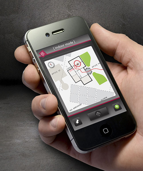
    Meridian In Their Own Words. “Meridian is focusing on providing software to allow employees of a location-based business to create an indoor way-finding app for visitors. The system enables a customer to upload maps (CAD, etc.) that are then converted into vector files.  Points of interest and turn-by-turn directions can be generated. The turn-by-turn directions can work with any wireless connectivity, from basic 3G to more sophisticated Wi-Fi systems. Indoor venues can achieve a GPS-like experience — that ‘glowing blue dot on the map’ — some are seeking. Meridian is seeing adoption from retailers, hotels and hospitals.” Jeff Hardison, Meridian

    Micello In Their Own Words. “Micello is a provider of indoor venue maps, including shopping malls, airports, college campus buildings, hospitals, retail stores, casinos, and stadiums in over half-a-dozen countries throughout the world. Micello uses proprietary, in-house mapping and navigation tools combined with map-manufacturing tools and dashboards. The technology ingests various sources of data and information about a given venue to create a well-defined, structured set of indoor map data. In the next 36 months, every building will have an app and mapping technology, integrated with positioning technology. Information will be automatically sorted and organized for users based on where they are located inside.” Ankit Agarwel, Micello

    Point  Inside In Their Own Words. “Point Inside provides retailers with detailed indoor maps, exact product location, and dynamic shoppers locations to help stores engage with in-store customers. The user’s shopping list, which is entered into the application, enables high-converting, hyper-targeted advertising.  With indoor location technologies advancing too quickly to pick a single winner, Point Inside uses proprietary algorithms to combine results from multiple location technologies to determine the most accurate fix. Primary technologies include: proprietary Wi-Fi fingerprinting, motion sensing to determine movement from known locations (such as product locations); partnership with other location providers; and correlation with indoor maps to determine valid locations.” Todd Sherman, Point Inside

    How does this shake out? It is too early to tell. In the coming year, I expect the indoor location market will be better formed. Consolidation will occur. Some companies will drop out and others will be purchased. Grizzly Analytics suggests eBay, Local.com, Amazon, Microsoft, Apple, GroupOn, TI, Qualcomm, CSR, Google, foursquare, and Google are all shopping or looking for strategic alliances to develop indoor location offerings. Time will tell who eats pie.

  • Indoor Positioning May Need Several Solutions, Says IMS Research

    A range of solutions are vying to replicate what GPS does outdoors in an indoor environment, from Wi-Fi to Bluetooth to “terrestrial” GPS, plus many others. Which one is likely to be successful? IMS Research (recently acquired by IHS Inc.) said the answer will not simply be just “one.” Locating a smartphone in an outdoors environment is straightforward, with more than 90 percent of smartphones providing GPS functionality. However, GPS becomes less useful in built-up areas and can be useless indoors, reports IMS Research.

    Indoor location enables a number of exciting applications that may previously have been considered impossible, for both the consumer and the venue owner, said IMS Research. Not only can it provide analytics, tracking footfall and understanding consumer behavior, but also improve the shopping experience, helping the consumer to find a particular store or product. Whilst these examples are useful, the real benefit and revenue generation is likely to arrive in the shape of advertising.

    Bluetooth in Nokia’s HAIP variety can provide accuracies claimed to be less than one meter, making it suitable for “aisle level” positioning. NextNav is beginning to roll out a technology described as “terrestrial GPS” in the United States, using transmitters based on the ground, and the existing GPS chipsets found in many smartphones. Other solutions include the IMES system in Japan and cellular-based solutions from companies such as Path Intelligence.

    While the roll out of commercial solutions has only recently begun, Wi-Fi has, to date, been the primary technology used. “Its high penetration in smartphones, combined with an existing infrastructure of access points, in venues such as shopping malls and airports etc., means minimal additional investment is required to support some level of positioning solution,” noted Alex West, Connectivity and Location research director at IMS Research. “For this reason, a range of different companies from Google, to Qualcomm and CSR, to Qubulus, all have solutions incorporating Wi-Fi.” Current location accuracies through Wi-Fi make it suitable for “store-level” positioning but less so for product or aisle-level, although IMS Research forecasts that consumers’ exposure to store-level accuracy will drive demand for aisle/product-level accuracy.

    In reality, it is unlikely that one solution will meet all requirements, and among recent announcements is CSR’s SiRFusion platform, which uses not only Wi-Fi, but also cellular and MEMS sensors such as accelerometers and gyroscopes, to provide a hybrid solution. MEMS sensors, which are becoming increasingly common in smartphones, are expected to play a bigger part in positioning, not only improving accuracy levels but also aiding in cutting down power consumption.

    Other leading IC suppliers, including Broadcom and Qualcomm, have announced solutions incorporating these technologies, and Bluetooth in some cases, with the necessary software. As such, a more accurate indoor positioning service is expected to be included on smartphones over the next 12 months, and is expected to provide the platform for the many apps and services that are being developed utilizing indoor location, according to IMS Research.

  • Expert Advice: Getting to Accurate Everywhere Location

    Brock Butler
    Brock Butler

    By Brock Butler

    In the next two to four years, mobile device location platforms will be able to provide positioning performance that enables emergency call (E911) and location-based services (LBS) with excellent accuracy (5–10 meters) in all locations. We call this accurate everywhere location, and it will be a significant enabler of indoor navigation applications and for even wider adoption of consumer LBS.

    In fact, we may eventually forget how we ever lived without it. This technology can enhance our lives by enabling our mobile devices to know precisely where we are at all times. Armed with this information, our devices can behave in a way that suits our specific situation, and they can do this without us having to do anything other than keep the phone with us.

    Text and images will get significantly bigger while driving or walking. Facebook notifications can be automatically disabled while at work. Shopping lists can be automatically displayed when approaching a store that has an item on the list. The potential benefits are endless — provided that the privacy issues associated with location are handled appropriately.

    GNSS is the superior technology when a mostly unobstructed sky is available, but it can’t deliver accurate position fixes in all environments — at least not at a cost and in a form factor that works for consumer mobile devices. Accurate everywhere location requires some form of advanced hybrid location technology. Because its definition is constantly evolving, the term hybrid can mean different things to different people. This article aims to clear that up.

    Here is an overview of the hybrid positioning technology currently used in mobile devices, as well as what is coming in the next two to four years that will enable accurate everywhere location:

    GPS + GLONASS. Multiple GNSS technologies are starting to be more common in new chipsets aimed at mobile devices, and assisted-GPS (A-GPS) + A-GLONASS is right around the corner. The benefit from this hybrid GNSS approach is that with more satellites in the sky, devices are likely to receive more line-of-sight signals in challenging environments where a significant portion of the sky is obstructed (like urban canyons). While this might improve performance on a street in downtown Manhattan, it does not help when you are in the middle of a building or in the subway.

    Cellular Multilateration + A-GNSS. Mobile devices with CDMA cellular radios have supported hybrid A-GPS + advanced forward-link trilateration (AFLT) for more than a decade. This concept is now being applied to long-term evolution (LTE) devices, with support for A-GNSS + observed time difference of arrival (OTDOA) being written into the 3GPP standards. Both AFLT and OTDOA are forms of cellular multilateration, which means that devices can make measurements of relative timing offsets between multiple downlink cellular signals, and those measurements can be used in a hyperbolic multilateration formula to compute a position (one signal acts as reference and hyperbolic intersection of 2+ signals are used for position).

    Does this sound familiar? It happens to be very similar to GNSS location computation, so it is possible to combine measurements from cellular signals and measurements from GNSS satellites to compute a hybrid position. For example, 2 satellites + 2 cellular measurements can be combined to compute a position, which makes this technique very attractive. Although it is used for both E911 positioning in North America and LBS worldwide, this technology will become even more widespread as LTE adoption increases.

    A-GNSS + Wi-Fi Positioning + eCID. Many popular smartphones today support Wi-Fi positioning and enhanced cell ID (eCID) in addition to A-GNSS. This hybrid solution allows coarse positioning in indoor environments where A-GNSS does not work. Solutions for Wi-Fi and eCID positioning are currently very fragmented and proprietary. However, this is the reason you are able to get a semi-accurate position fix on your Android or iOS mobile device when GNSS satellites are impossible to measure (many other devices support this as well). These technologies are going to provide more accurate information as time goes on, but we don’t believe they will achieve accurate everywhere location on their own.

    A-GNSS + Wi-Fi Positioning + Cellular Positioning + Sensors. You might have guessed it, but we think accurate everywhere location will be enabled by a combination of all the above hybrid techniques plus one more important technology: sensors. Integrated sensors like accelerometers, magnetometers, and barometers enable devices to sense changes in direction, orientation, and elevation. Given an accurate starting location (for example, GNSS position fix), sensors can track location accurately for several minutes (and this will continue to get better). Location error will accumulate over time, but this can be minimized when Wi-Fi, cellular, and GNSS positioning are used in conjunction to constrain the error. Furthermore, barometers can be used to track elevation changes, thereby allowing devices to know exactly what floor of a building a user is on. Other technologies, or signals of opportunity, may be used in the future to further improve performance, but we think this mix of A-GNSS, Wi-Fi, cellular, and sensor positioning is the key to accurate everywhere location in mobile devices.

    With substantial R&D dollars being spent now, and standardized testing for hybrid positioning emerging this year, our best estimate is that the accurate everywhere technology will become commercially widespread by 2015.


    Brock Butler is director of Spirent’s Wireless Location Technologies, part of a team that has made major contributions to development of the LBS standards in the 3GPP: Spirent filled the editor and rapporteur roles for the TS 51.010 and TS 34.171 A-GPS Terminal Conformance Specifications, as well as the editor role for the Enabler Test Specification for SUPL in the OMA. Butler holds a BSc in electrical engineering from Villanova University.