Yesterday we posted news of an 11-hour downtime for the full GLONASS constellation, due to an upload of bad ephemerides. Coincidentally, during that 11-hour period, the mass-market chip company Broadcom was conducting multi-constellation receiver tests in Asia. Frank van Diggelen, Broadcom’s chief GNSS scientist and vice president says, “We have definitive data to show how a multi-constellation receiver survives such an outage.”
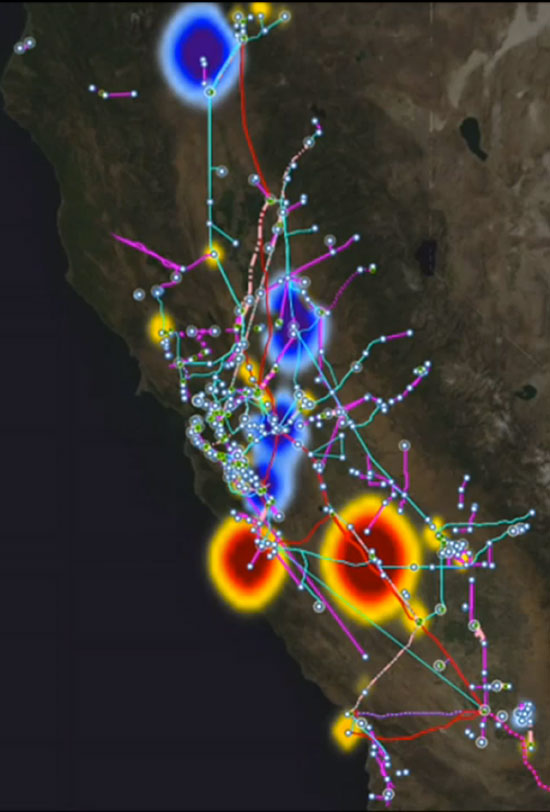
Here are the pictures, and the story they tell.
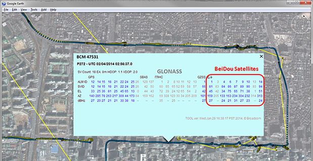
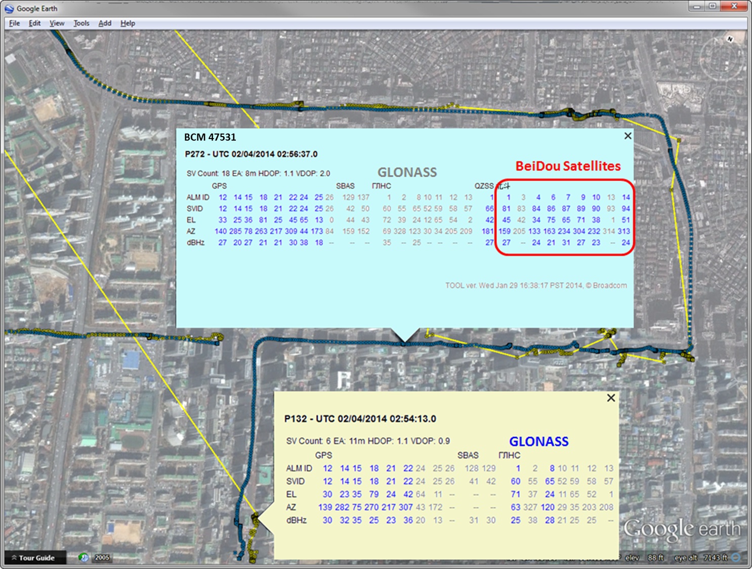
Test data coincident with the GLONASS ephemeris disruption of April 1 and 2 showing conclusively how a GPS/GLONASS/QZSS/BEIDOU receiver survives the complete disruption of one of the constellations.
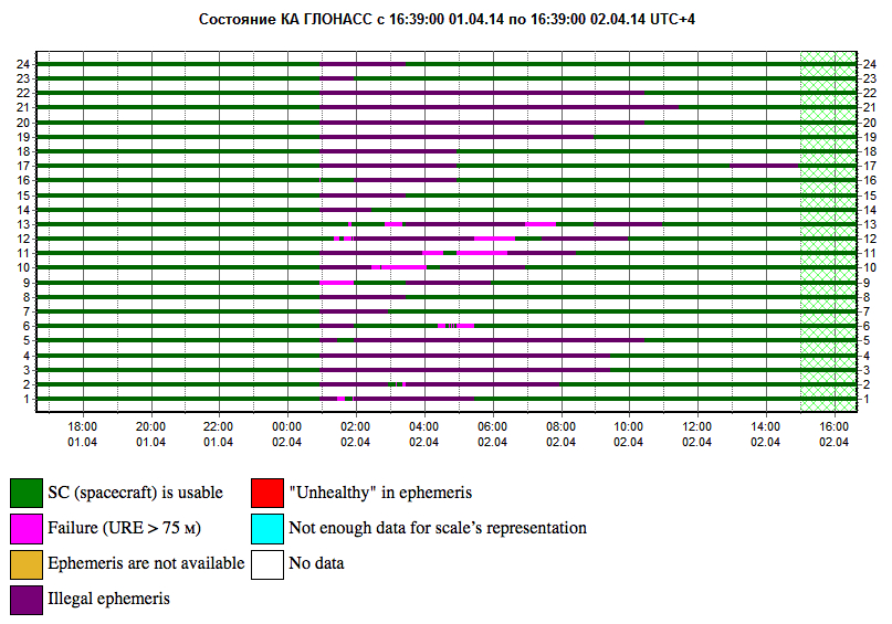
On April 2 at 1:00 a.m. Moscow time, bad ephemeris was uploaded to all satellites (see chart at the bottom of this story).
There are two receivers shown here, from two different manufacturers, both in smartphones. The yellow dots are for a GPS/GLONASS receiver; the blue dots are from the Broadcom 47531 receiver which tracks GPS/GLONASS/QZSS/BeiDou signals simultaneously. The 47531 receiver includes logic to use redundant measurements to check the validity of all measurements. It successfully identified and removed the bad GLONASS ephemeris 100 percent of the time, as can be seen by the continuity and accuracy of the positions.
Here is the satellite outage chart from yesterday’s story. All GLONASS satellites were restored to healthy state after the 11-hour interruption.
Current plot from the Roscosmos GLONASS Information-Analytical Centre. Things are almost back to normal this morning.
When one talks about the worldwide location industry, mobile resource management — fleets and trucks, for instance — aren’t sexy at all, but they make money. What is supposed to be sexy is location-based advertising. According to many analysts, location-based advertising has been hampered by a few things: education for both consumers and mobile advertisers, privacy issues, and relevant proximity information so folks can use it to make purchases. Another concern could be the expense of rolling out indoor beacons.
BARCELONA—Major consumer privacy concerns aside, companies are starting to see growth in location-based advertising, with new markets emerging in Europe. While the numbers of mobile advertising companies has decreased at the Mobile World Congress, held here in February, from just two years ago, the remaining players are seeing a more mature market.
Mobile advertisers are beginning to realize that location is the Holy Grail for growth, said Cameron Peeples, Airpush vice president of marketing. “People going into New York from Newark during rush hour can receive a different call to action because of a created geo-fence. Advertisers can determine whether the traveler is there on business or looking for a hotel and other travel deals,” he said.
Before Mobile World Congress, Los Angeles-based Airpush partnered with AirX, a large mobile ad exchange company. The majority of the AirX inventory, about 120,000 Android applications, includes highly-sought-after GPS location data, the company said.
There are large differences between the North American and European markets for mobile advertising, Peeples said. “The mobile advertising market [in Europe] is definitely evolving. The European market is key for us, dramatically higher than other markets,” he said. “[The European] market seems to have people connected to a lot of things — they are more mobile, use public transportation more, and always have a phone that is more centric to who they are.”
Making location-based advertising relevant to the consumer is still a major challenge. “Our focus next year is on native advertising. Native advertising combines not only the right message, but the right delivery vehicle,” Peeples said. “No one bicycling enthusiast wants ads tailored for someone who wants flowers.”
Peeples said the privacy issues are a big deal, but his company’s services are opt-in. “A lot of it is loyalty advertising. It’s all opt-in,” he said.
xAd Partners with Waze, Sees UK Growth
Another mobile advertising company, New York-based xAd, is also making inroads in Europe. “We are in the UK right now, which is really WiFi-focused. A lot of our early [location-based] advertising efforts are in education — to educate consumers and the advertising agencies about the power of location and mobile,” said Monica Ho, xAd vice president of marketing. “Not all location is created equal. The real value of [location-based advertising] is the proximity target to market to.”
Right before Mobile World Congress, Waze selected xAd as its third-party provider of search and display mobile ads in the United States. Waze, which was bought by Google in a deal worth more than $1 billion, is a top three map and navigation app in the iTunes store — a ranking that was probably helped by the Apple Maps debacle in 2012.
The companies say the deal will place xAd’s mobile ad targeting technologies into Waze’s location-based advertising platform.
Ho said there are still two areas of concern for location-based advertising: relevancy to the consumer and privacy issues. “There was privacy backlash from Nordstrom collecting consumer information from their Wi-Fi system,” she said, referring to the controversy last year when the retailer was accused of capturing consumer information during an indoor positioning test.
Apple to Roll out Upgraded Maps on iPhone 6
Speaking about Apple Maps, many industry analysts says the company has come a long way since the very public embarrassment nearly two years ago over map inaccuracies and flaws. The company recently released iOS 7.1, but is expected to rollout iOS 8 when the iPhone 6 debuts later this year.
With the debut of the iPhone 6, an updated version of Apple Maps will also be released, according to published reports.
Last year, Apple bought two companies, HopStop and Locationary, to allow the company to entrench itself once more in the location business. How firmly those roots prove to be, and how well they serve the company against archrival Google, remain to be seen.
Apple has been stockpiling companies and mapping software since its introduction of Apple Maps on iOS devices, which had a rough start. GPS World’s LBS Insiderreported extensively on the problems Apple encountered with its mapping software. Some of these problems included sending drivers to a wrong location and direction.
After the mapping software problems were made public, Apple CEO Tim Cook apologized for the mapping software’s problems and even suggested that users go to such competitors as Waze, MapQuest, and Microsoft’s Bing.
In other location news:
A Wall Street Journal reporter basically said there was nothing much new at Mobile World Congress — and that the excitement and action was at the outlying conferences at Fira Montjuic. One of these more interesting conferences, Four Years From Now, or 4YFN, featured start-up companies making pitches and displaying their new products, some of which included location capability.
The Mobile World Congress final stats. Organizers said MWC had more than 85,000 attendees from 200 countries — an increase of 13,000 from the previous year. It’s now being touted as the biggest and best wireless show.
In February, GPS World reported that TruePosition had purchased Skyhook for an undisclosed price. Skyhook provided location services to a number of companies including Apple and Samsung. The interesting issue is Skyhook’s lawsuit with Google, which alleged that the Internet giant influenced smartphone manufacturers to abandon the Boston-based company. According to published reports, the legal action still is going forward.
AT&T Mobility is shuttering its location-based Alerts marketing program. The company said it would release an updated version later this year. AT&T Mobility launched Alerts in late 2012. It featured free opt-in, location-based text message alert service. Participating retailers included Stapes, Gap, Zales, Neiman Marcus, and others.
I didn’t go to South by Southwest. Is my cool-guy card revoked? One of the reasons I didn’t is because, outside of meetings that were not part of the conference, there was not one location industry announcement made there. Maybe something will change my mind next year, but call me an old fogey — I just didn’t see the need to go to Austin this year.
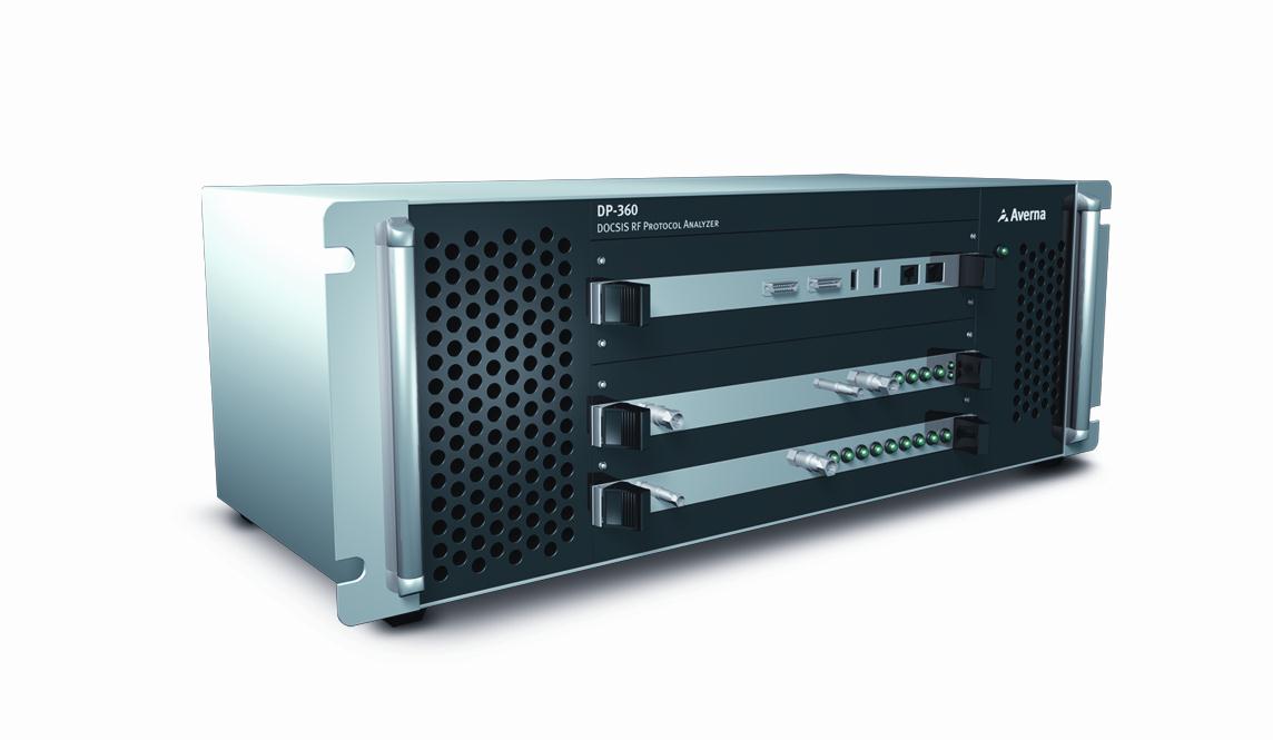
Averna has issued a new software release for the DP-360 DOCSIS Protocol Analyzer, featuring support for 16×4 channel bonding for broadband testing.
Averna’s DP-360 provides functional DOCSIS and EuroDOCSIS network analysis, allowing for exceptional visibility into all layers of the network, the company said. Multiple system operators (MSOs), chipset manufacturers, product developers and certification bodies use the DP-360 to quickly find and correct trouble spots.
New DP-360 release highlights:
Supports up to 16 single or bonded downstream channels for testing 16×4 configuration.
Upstream gain control, MER reading and power reading available in the remote API for automated power adjustment.
Automatic detection of modulation type (64-QAM or 256-QAM) and DOCSIS on downstream channels and lock on 4 upstream frequencies for faster setup and analysis.
Support for DOCSIS 3.0 Energy Management messages (EM-REQ & EM-RSP).
DP-360 clients also have access to Averna’s new DOCSIS 3.1 Early Adopter Program, which offers MSOs and equipment vendors a smooth and cost-effective transition to Averna’s next-generation solution for testing their cable equipment based on the new DOCSIS 3.1 standard. Contact us for more details.
“Our DOCSIS 3.1 Early Adopter Program covers current D3.0 as well as upcoming D3.1 testing needs and is specifically designed to make the technology switch as easy and cost effective as possible for our clients and partners,” commented Alex Pelland, Director of Broadband Test Strategy for Averna. “The DP-360 is the most advanced DOCSIS protocol analyzer available today and, with our forward-looking transition program, it will provide a substantial return on investment for years to come.”
The new DP-360 software release is available at no cost to customers with a valid DP-360 maintenance and support agreement.
SyncWorld will enable power utilities to react in real time to outages and alert users to contingency plans.
Symmetricom has introduced a new category to its SyncWorld Ecosystem Program dedicated to the power utility industry. Developed to support integration and interoperability among power utility and Symmetricom solutions, the SyncWorld Power Ecosystem aims to facilitate unified deployments of timing and synchronization in substation modernization and synchrophasor applications.
As power utilities shift to the Smart Grid, they gain the ability to monitor in real time, allowing for proactive operations control. Advanced synchronization and timing enable power equipment to operate more efficiently and closer to its operational limits.
For example, one microsecond accuracy is required by the phasor measurement unit (PMU) for real-time network situational awareness and overall operational efficiency. Without accurate time stamps, PMU data has limited value. For power utility companies, that translates into enhanced network utilization rates as well as smarter management and mixing of renewable and traditional power sources.
The introduction of the SyncWorld power segment is expected to drive collaboration and innovation among the industry’s leading power utility vendors. To participate in the program, vendors work with Symmetricom to develop a joint solution, complete successful solution testing, and commit to ongoing technical and business activities to ensure joint success.
Interoperability is a key requirement to join the program. Using various test cases with a defined standard for testing, Symmetricom focuses its assessment on the performance of a product’s IEEE 1588 power profile. During testing, Symmetricom clocks act as the master clocks, switches act as transparent clocks, and IED/PMU products act as slave clocks.
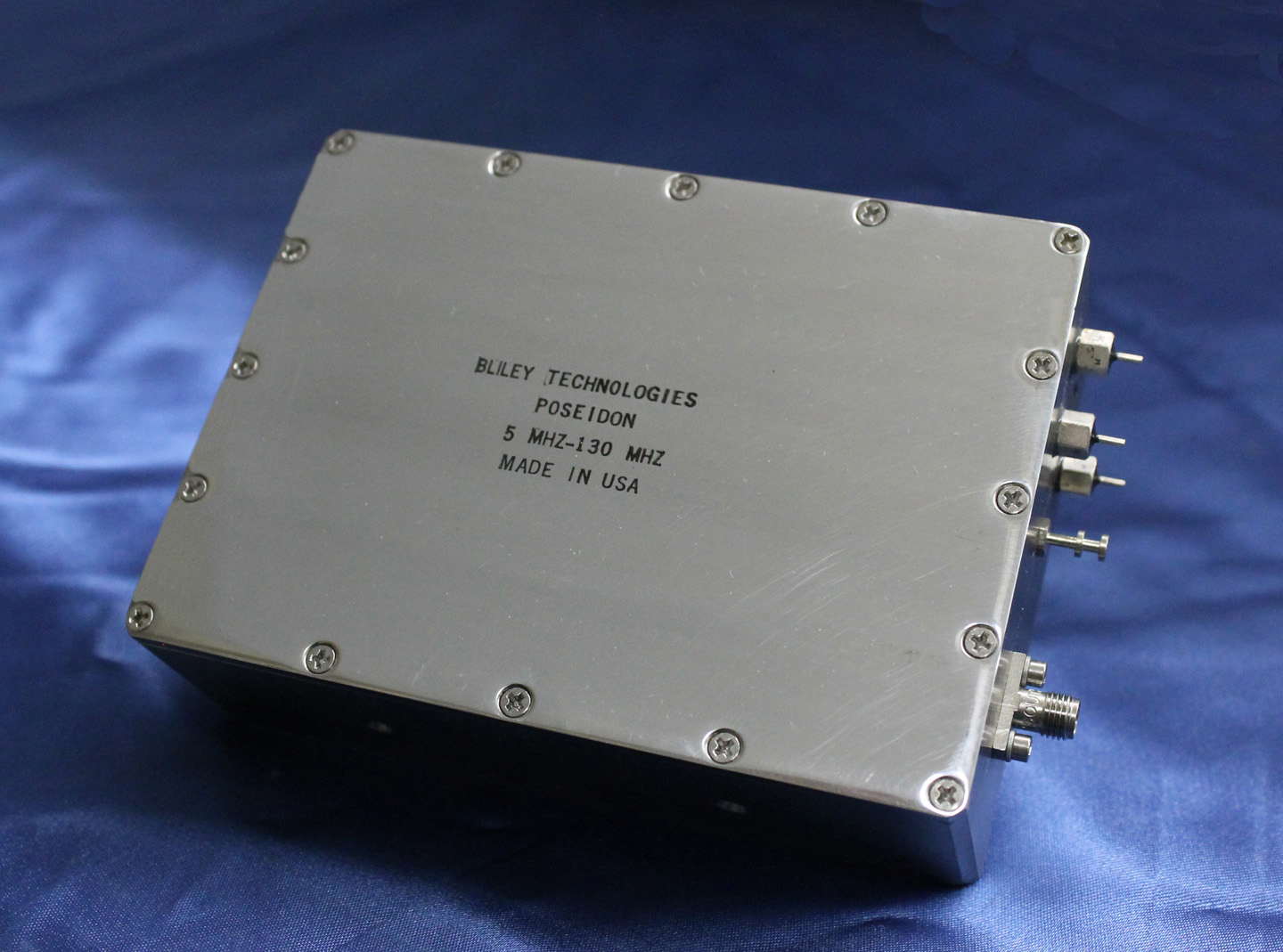
The rugged Poseidon Series of OCXOs by Bliley features unparalleled phase noise performance in a modular type sealed package. It is a customizable frequency range product specifically designed for vibration-prone environments where dynamic phase noise performance is paramount. Applications include ground mobile, airborne, and shipboard environments.
Features include typical acceleration sensitivity of <2e-11/g, excellent FvT performance, frequency range of 5 MHz to 130 MHz, ultra-low static and dynamic phase noise, and excellent long-term aging.
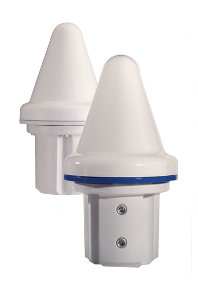
The VIC100 Series antenna by Panasonic is an active L1 GPS antenna designed for timing and synchronization. It offers immunity to noise and interference, and secure performance by attenuating noise and interference near the GPS L1 frequency through triple-filtering design.
The VIC100 Series is housed in a waterproof enclosure designed for excellent performance under severe environmental conditions. Its shape prevents accumulation of snow and ice, eliminating problems with bird perching and enhanced immunity to lightning surge.
Microsemi Corporation, provider of semiconductor solutions differentiated by power, security, reliability and performance, today announced the highest density family of single-chip timing card devices with support for both Synchronous Ethernet (SyncE) and IEEE 1588-2008 packet networks including 4G and LTE applications. The highly integrated ZL30361, ZL30362 and ZL30363 provide all of the key elements required for wireless network synchronization including support for phase and frequency. The devices are available today and are currently being designed into wireless backhaul products where phase synchronization performance is crucial.
Microsemi’s new timing devices provide the high flexibility, small footprint (13mm x 13mm) and low cost compared to alternative solutions. Key features include the availability of up to four independent timing channels; each channel can be configured to support any electrical or packet mode of operation. This allows for the simultaneous support for GPS, SyncE and IEEE1588-2008 timing. As a result, these devices can be used to enhance or to replace GPS timing in wireless infrastructure at a lower cost.
“Our new SyncE/IEEE1588 solutions provide customers with a highly compelling value proposition and very flexible architecture as evidenced by several product design-ins already in development by leading telecom companies,” said Maamoun Seido, vice president of Microsemi’s Timing Products group. “These offerings are indicative of the innovative products that have made us the No. 1 provider of network timing semiconductor solutions globally, and the new products in our pipeline will help solidify our leadership position.”
SyncE and IEEE 1588-2008 technologies allow carriers to improve synchronization and performance in packet-switching networks including the fast-growing 4G and LTE segment, which, according to a report from market research firm Infonetics, is rising from $8 billion in 2012 to a forecasted $17 billion in 2016.
Telit Wireless Solutions has been selected among various applicant members of the Italian Technology Industry as one of the nation’s key representatives in the global roll-out of Europe’s Galileo satellite positioning system. The selection reflects the high degree of credibility demonstrated by the Italian government in the strategic plan proposed by Telit to accelerate global adoption of the Galileo technology, Telit said.
Telit is a global enabler of machine-to-machine (M2M) communications providing cellular, short range and positioning module products. Telit’s positioning technology R&D center is an integral part of the company’s R&D function headquartered in Trieste, Italy.
Telit also received a grant to execute its proposed strategic plan. The grant offers Telit the opportunity to accelerate its activities in development of projects for the positioning technology market. It bolsters human and financial resources required to enable Telit to quickly advance in this market area and achieve leadership in product performance with services to match. This achievement is likely not only to enhance the company’s competitiveness but is also provide measurable boost for the Italian economy, concretely contributing tangible progress in the strategic and very high growth segment of m2m.
The inclusion of positioning expertise stems from the company’s mergers and acquisitions over the past few years, which have made it a leading designer and manufacturer of innovative GNSS solutions for OEM applications, from personal and asset tracking to automotive solutions. Telit has sold millions of high-performance GPS modules sold worldwide.
Galileo is Europe’s global navigation satellite system, designed to provide a highly accurate, guaranteed global positioning service under civilian control. It is inter-operable with GPS and GLONASS, the U.S. and Russian global satellite navigation systems. By offering dual frequencies as standard, Galileo delivers real-time positioning accuracy down to the meter range. It ensures availability of the service under all but the most extreme circumstances and informs users within seconds of any satellite failure, making it suitable for safety-critical applications such as guiding cars, running trains and landing aircraft. A range of services will be extended as the system is built up from initial operational capacity (IOC) to reach the Full Operational Capability (FOC) by this decade’s end. The fully deployed Galileo system consists of 30 satellites (27 operational + 3 active spares), positioned in three circular Medium Earth Orbit (MEO) planes at 23 222 km altitude above the Earth, and at an inclination of the orbital planes of 56 degrees to the equator.
“Achievement of a leading position in now in Galileo technology not only boosts Telit’s global stance and strength, and consequently that of the Italian technology industry but also extends the reach of our leadership in positioning which already includes two decades of pioneering work in GPS in the United States,” said Dominikus Hierl, chief marketing officer at Telit Wireless Solutions. “The planned work-force expansions in support of this new effort will create extraordinary value-add, not only in terms of project acceleration but also in innovation, vision and new relationships for Telit.”
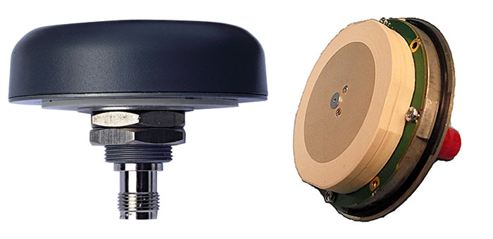
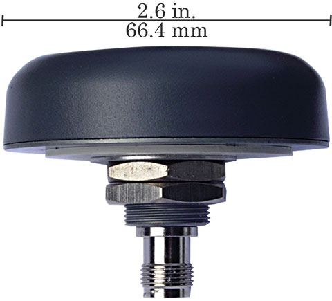
TW3802 Shown with flat radome. Conical radome also available.
Tallysman Wireless Inc. has added the dual-frequency TW3800 series to its high-quality precision line of antenna products.
The TW3800 series antennas feature a circular stacked patch antenna for improved axial ratio, yet are small and light, and have the extended bandwidth required for L1/L2 GPS & G1/G2 GLONASS, the company said. The operating voltage range is from +2.5 to 16 VDC. The antennas have a temperature compensated LNAs and operate from -40 to +85o C to provide reliable performance in most any environment. The TW3800 is packaged in a through hole mount making it suitable for mobile applications.
The TW380x is suited for many applications, including:
Anti-jamming GPS
Mission-critical GPS timing
Military and security
Network timing and synchronization
Precise tracking
High signal availability
The TW3805 is the OEM version of the TW3802, and can be custom tuned to provide optimal performance inside virtually any housing, Tallysman said.
“The circular patch design of the TW380X antennas permits precision custom tuning with excellent axial ratios.” said Gyles Panther, president of Tallysman Wireless. “This flexibility, combined with the very wide operating voltage enables this antenna to work with virtually any receiver on the market.”
Three-fifths of all smartphones, tablets, and notebooks shipped worldwide during the first quarter of 2013 run Google’s Android mobile operating system, independent analyst firm Canalys reports.
Manufacturers shipped 308.7 million smart mobile devices between January and March, Canalys states. Android powers 59.5 percent of all shipments. Apple’s iOS ranks a distant second at 19.3 percent, fueled by its strength in the smartphone and tablet markets, followed by Microsoft at 18.1 percent, buoyed by its relative strength in the notebook segment. Rival platforms including BlackBerry account for the remaining 3.1 percent.
Among the three device categories under the microscope, the tablet market continues to experience the fastest growth: Worldwide tablet shipments grew 106.1 percent year-over-year to 41.9 million units. Apple continues to lead tablet shipments with a 46.4 percent share, but Android-based rivals narrowed the iPad’s lead for the third consecutive quarter.
“Spearheaded by Google and Amazon, the commoditization of the tablet market has happened far quicker than that of the wider PC market,” said Tim Coulling of Canalys. “Profit margins are being squeezed and vendors without a low cost structure will find it hard to compete. A solid range of must-have accessories and a software and services strategy are vital as vendors will increasingly need to make revenue around their devices.”
Smartphone shipments eclipsed 216.3 million during the first quarter, up 47.9 percent over year-ago totals. Android accounted for 75.6 percent of all smartphone shipments, led by Samsung Electronics, which increased its volume 64.3 percent year-over-year to capture 32 percent market share. Apple’s iPhone shipment volume grew just 6.7 percent over the first quarter of 2012, the smallest increase since the launch of the original iPhone back in mid-2007.
The GPS Fiber Optic Distribution system from Optical Zonu connects up to 32 remote locations, transporting GPS signals from a single antenna to as many as 32 GPS receivers (or multiple antennas to multiple receivers). A common example of this application is a campus scenario where installing multiple GPS antennas is impractical. This particular system consists of the OZC J‐Series 5‐Slot modular 1U chassis. The Master Unit is located within close proximity of the GPS antenna and it contains modular and hot‐swappable fiber optic transmitter, AC power supply and J Optical Splitter cards. The remote unit is a stand‐alone (wall mountable) unit. It comes in a low profile semirugged package. A single 1U chassis at the master site is capable of supporting up to 32 remote locations.
The optical transmitter module has built‐in LNA for high sensitivity detection of low level GPS signals. The Master Unit also has a Bias‐T to provide DC power to the GPS Antenna. Local monitoring is also integrated into the Master Unit, which is accessible via a single computer interface terminal. The maximum RF input signal into the transmitter is ‐25 dBm and the RF interface is via a 50 Ohms SMA connector. The standard optical connector is SC/APC (FC/APC is also available upon request) for low back reflection applications. The system is designed to operate on single mode fiber but may be custom configured to work on multimode fiber. The system is configured for complete dual redundancy, including additional fiber optic Tx module for a second GPS antenna.
TeleCommunication Systems (TCS), a provider of mobile communication technology, announced that its TCS VoLTE9-1-1 service is first into production with Tier-1 wireless carriers, including two of the largest North American operators. The fully customizable solution enables 4G/LTE carriers to provide both 911 call routing and originating coarse/precise location information, including the 10-digit callback number, to public safety access points (PSAPs).
Initially, wireless carriers deployed 4G/LTE solely for data use. Without VoLTE9-1-1 capabilities, carriers must process emergency calls over 3G networks (circuit-switched fallback), even in areas where LTE is deployed. However, with TCS’ VoLTE9-1-1 service, they can now process 911 calls in an all-LTE environment, enabling them to reclaim or reuse 3G spectrum.
“As carriers increasingly move toward LTE networks, the ability to handle 911 emergency communications is critical,” said Thomas Ginter of TCS. “By leveraging VoLTE9-1-1, network operators are helping to ensure subscribers receive the responsiveness they need in an emergency situation, while expanding coverage to areas where 3G coverage is lacking.”
TCS VoLTE9-1-1 features:
Call routing to the PSAP: The TCS VoLTE9-1-1 service routes a 4G/LTE-originated 911 call using coarse location via the route determination function component.
PSAP telecommunicators can call back if disconnected: The TCS VoLTE9-1-1 service remains fully backwards compatible, supporting necessary functions such as providing PSAPs with full 10-digit subscriber callback numbers.
Re-bid by a PSAP for precise location after call routing: The location retrieval function allows a wireless carrier complete flexibility in choosing its underlying high-accuracy location technology and supports updated/precise position requests.
Emergency voice call continuity for location service: Location continuity and location delivery to the PSAPs are supported in usage scenarios where the 911 call switches from 4G/LTE to 3G/2G networks.
Expansion beyond voice: As wireless networks advance, multimedia objects such as text, audio and video can be transferred to a compatible termination point with LTE IP networks, for example, an NG ESINet and i3 PSAP. Leveraging an all-IP network makes it easier and more cost effective to interconnect services.
Small cell support: The TCS VoLTE9-1-1 solution supports small cells, including femtocells, microcells, and picocells, which are now commonly used in dense urban, indoor areas and enterprise networks.
TCS supports half of all U.S. wireless E911 calls, serving more than 140 million wireless and IP-enabled devices. The company holds more than 280 patents, 43 of which relate to public safety, and more than 360 pending worldwide.