FlytBase debuted its FlytGCS, a cloud-based remote drone operations solution, at AUVSI Xponential 2019, which took place April 29-May 2 in Chicago.
Tag: Xponential 2019
-
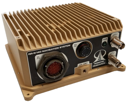
Robotic Research provides navigation system for GPS-denied areas
Photo: Robotic Research Robotic Research will showcase its RR-N-140 navigation system at Booth #407 at AUVSI Xponential 2019, which takes place April 29-May 2 in Chicago.
The system provides accurate, absolute and relative 3D (six-degrees-of-freedom, or 6 DOF) localization information for ground vehicles of all sizes.
The device delivers exceptional localization performance in GPS‐denied or compromised areas. It is designed specifically for use on unmanned ground vehicles and is heavily customizable to incorporate a wide variety of sensor inputs into the navigation solution.
Robotic Research develops and deploys autonomous vehicle innovations for both commercial and government customers.
Features of the RR-N-140 include:
- Accurate, real-time navigation/localization solution for wheeled or tracked ground vehicles
- Adaptable for use on surface vessels
- Exceptional localization performance in GPS-denied or compromised areas
- Dual antenna GNSS for zero-speed heading detection and redundancy
- Rugged IP67 Construction designed to meet shock and vibration environments typical of military vehicles
- Up to 4X configurable vehicle speed / encoder inputs
- Configurable GNSS and IMU options allow tailored solutions for all levels of performance
- Customizable to directly interface with and process a variety of sensor inputs (e.g. LADAR, Stereo and Monocular Cameras, Ultra-Wideband Ranging Radios)
- Easy integration with the Robotic Research Warfighter Localization family of systems (WarLoc)
- Web interface for user-level diagnostics and configuration
- Ethernet, CANbus, and RS-232 Serial Data Interfaces
- Independent Ethernet ports for separation of navigation solution and sensor processing data
- Robust Built-in-test (BIT) error reporting during runtime
- Redundant IMU and GNSS options available for fault-tolerance
- NTP Server and GPS PPS signals for time synchronization
- Low SWAP
- 7.2”L x 6.4” W x 2.9” H
- 4.0 lbs
- 22W at 9.5-36 VDC
-

GE Aviation and Auterion team on commercial drone platform

Photo: iStock.com/valio 84sl, via FAA Team to provide all-in-one hardware and software platform for commercial drones.
GE Aviation and Auterion are integrating the Auterion Enterprise PX4 operating system on GE Aviation’s Unmanned Aircraft System avionics platform.
The companies signed a teaming agreement to provide a comprehensive hardware and software solution for drone manufacturers and operators seeking to enable commercial drone operations at scale.
The hardware and software platform is designed with commercial vehicle original equipment manufacturers (OEMs) and service providers in mind. It is being displayed at Auterion’s booth (#2009) at AUVSI Xponential, taking place this week in Chicago.
The teaming enables a full-stack solution with airborne autopilot and application computing hardware, flight management, safety management and integration. GE Aviation is providing the avionics hardware, application computing, flight management and integration into airframes. Auterion is providing Enterprise PX4, the operating system that runs on the vehicle, in the cloud and the ground station.
The core architecture of the hardware and software platform has been implemented with the objective of supporting developers through global open software standards while maintaining an independent and authoritative safety controller.
The combination of the two supports long-term flexibility and a high level of design assurance to enable commercial drone operations beyond visual line of sight (BVLOS) and within complex airspace and obstacle environments.
Flight testing of the hardware and software platform took place over the last three weeks at Reno-Stead airport in Reno, Nevada.
“In demonstrating a seamless integration of ground, cloud and airborne components, we’ve reached another milestone in helping to unlock the value in autonomous and UAS advanced operations,” said Alan Caslavka, president of Avionics Systems for GE Aviation. “Auterion’s open standards leadership and cooperative legacy with the developer community is the foundation to scale a sustainable solution critical for commercial drones.”
“We are excited about the collaboration with GE Aviation that allows us to offer our operating system on high reliability hardware to meet future regulations,” said Kevin Sartori, Co-Founder of Auterion. “With this collaboration, the combined solution will significantly reduce barriers commercial cargo drones face flying in manned airspace or inspection drones to flying in urban areas.”
-
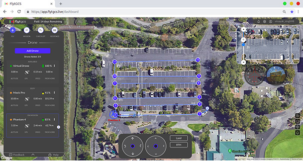
FlytBase launches FlytGCS for BVLOS drone operations
FlytBase Inc., an enterprise drone automation company, has launched of FlytGCS, a cloud-based remote drone operations solution, at AUVSI Xponential 2019.
FlytGCS is built for subject matter experts, drone operations managers and UAV operators who wish to automate, simplify and scale their missions. At its core is beyond-visual-line-of-sight (BVLOS) operations.
Photo: FlytBase To support the execution of automated BVLOS missions, FlytGCS offers a wide range of features including connectivity and control over 4G/LTE/5G, live high-definition video feed, fleet management, unlimited missions and unlimited drone addition, remote gimbal control, pre-flight checklist and geofence, mission planner and cockpit view from a web dashboard.
FlytGCS is a hardware-agnostic solution that helps securely deploy industry-standard drones over the cloud, for BVLOS operations, using a mobile app (for DJI drones) or onboard SBCs (for Ardupilot and PX4 drones).
Add-ons such as precision landing, fleet management, pilot team management and drone-in-a-box make FlytGCS a powerful, affordable and scalable alternative to traditional, expensive, desktop-based GCS products, the company said.
According to FlytBase, UAVs will create significant business value as soon as drone fleets can fly BVLOS. Technologists, regulators, business executives and drone operators all expect the industry to progress towards remote, autonomous, cloud-based drone operations across geographies, sectors and use-cases.

Photo: FlytBase “With FlytGCS, the power of autonomy is made available to drone operators, subject matter experts and service providers who can now seamlessly manage drones over 4G/5G networks, with best-in-class latency and live video quality,” said Nitin Gupta, FlytBase CEO. “As a SaaS product, this FlytBase offering helps our customers get started immediately, for free, and upgrade to the feature set that is best suited for their business needs. Operators have used FlytGCS in applications ranging from construction management and security/surveillance operations to emergency response and utility/asset inspections.”
-
Deseret UAS to showcase technologies at AUVSI Xponential
Deseret UAS unveils premier test facilities and technologies from Utah-based companies.
Deseret UAS will be exhibiting at AUVSI Xponential, offering commercial unmanned aerial systems (UAS)/urban air mobility (UAM) flight test facilities.

Deseret UAS headquarters is located at the Xperience Center in Tooele City. (Photo: Deseret UAS) Deseret UAS offers access to wide-open land and airspace, as well as the necessary Federal Aviation Administration (FAA) authorizations for large commercial UAVs and UAM aircraft.
The organization’s commercial flight test amenities include a 4,500-foot paved runway with a covered airplane hangar, mobile test units, certified Part 107 pilots, data analytics, beyond visual line of sight (BVLOS) test capabilities and state-of-the-art training facilities.
“We encourage all Xponential attendees to visit our booth and see firsthand the cutting-edge technologies being developed right here in Utah,” said Deseret UAS Board Chair Shawn Milne. “The unique assets we offer at an affordable cost have been a game-changer for companies seeking to operationalize their technologies.”
The Utah Pavilion will also have Utah-based companies exhibiting their prototypes that have the potential to revolutionize mobility, safety, and security.
Founded in 2017, ElectraFly is an aviation company building a hybrid-electric personal flying vehicle. It aims to increase lift capacity and flight times for vertical take-off and landing aircraft and is positioned between a personal jetpack and a large, helicopter-like air taxi.
The ElectraFly prototype is being built to carry a rider — something ideal for first responders or military special forces. Other versions will be scaled for air taxi or search and rescue, and smaller versions will be ideal for shipping and package delivery.
“There is an undeniable change happening in air transportation but there are problems in efficiency,” said John Manning, ElectraFly co-founder and director of development. “So many people, especially as children, dream about flying. We’re developing innovations to make the dream of personal flight a reality and to shape the future of urban air mobility.”
Fortem Technologies is an innovator in airspace safety and security. Fortem’s AI-enabled SkyDome software and TrueView radar digitize airspace, making it possible to ensure safe urban corridors and to protect infrastructure, venues, borders and cities against rogue drones. This digitization can make drone package delivery and the safe transport of people a reality.
“Safe air mobility of unmanned drones flying beyond visual line of sight is achievable,” said Fortem CEO Timothy Bean. “Fortem Technologies makes this possible by digitizing the airspace so that cooperative and non-cooperative air traffic can be differentiated, assessed for threats, and managed for safety of our airways.”
Also exhibiting at the Utah Pavilion will be officials from the Governor’s Office of Economic Development (GOED) and the Economic Development Corporation of Utah (EDCU). GOED and EDCU will be available to answer questions about economic development opportunities in the state.
“Utah has always been at the forefront of technological innovations that improve lives and the state’s investment in Deseret UAS is evidence of that,” said Ginger Chinn, managing director of Urban and Rural Business Services for the Utah’s Governor’s Office of Economic Development. “We whole-heartedly embrace unmanned aircraft technologies and are proactively developing a plan to build the aerial infrastructure needed for these innovations to flourish.”
-

Teledyne Imaging showcases mapping, object recognition and tracking tech at AUVSI
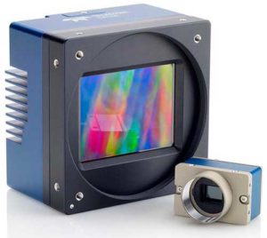
The Falcon 4 UAV camera. (Photo: Teledyne) Teledyne Optech, Teledyne DALSA and Teledyne Scientific & Imaging, all part of the Teledyne Imaging group, will share a combined presence at Booth #2520 at the AUVSI Xponential 2019 show in Chicago April 29-May 2.
The three companies will showcase their new and advanced sensor and imaging solutions.
Teledyne Optech presents a new compact lidar family, the CL-90. Attendees can preview the lightweight, compact lidar platform for UAV deployment. The CL-90 features exceptional canopy penetration, offering the low-noise, high-quality survey-grade data to deliver extraordinary performance in data accuracy and point precision.
The CL-90 empowers full lidar performance across the entire operating altitude range of the UAV, and offers an exclusive variable field-of-view capability eliminating the need for multiple passes over a target.
Teledyne DALSA will showcases its advanced thermal and visible cameras. The Genie Nano family of low-cost area cameras for UAVs are lightweight, power-efficient and compact.
The Falcon 4 86-megapixel ultra-high resolution and high-speed CMOS camera offers capabilities for large-area, high-resolution, high-speed imaging.
The Calibir series of long wave infrared (LWIR) cameras deliver compact, low-profile thermal solutions, designed for UAV applications such as agriculture, construction, defense and surveying. Calibir is customizable with smart embedded algorithms and capability for real-time VIS-LWIR image fusion.
Teledyne Scientific & Imaging features a new artificial intelligence (AI) software stack capable of real-time performance on board UAVs. The AI stack enables automatic sensor processing for applications such as sensor fusion, asset recognition and tracking, and adaptive dynamic range for deployment in daytime and variable light operations.
-
Attollo Engineering introduces WASP-200 laser rangefinder

According to Attollo Engineering, its WASP series of rangefinders are designed to measure ranges at a rate of up to 10,000 points per second. (Photo: Attollo Engineering) Attollo Engineering, a privately-held company focused on the design and manufacturing of laser sensing and infrared imaging devices, launched the WASP-200 LRF, a laser rangefinder with varied configurations. According to the company, its WASP series of rangefinders are designed to measure ranges at a rate of up to 10,000 points per second with remarkable accuracy and precision in a tiny package.
The WASP-200 LRF can be used for precision agriculture applications and as a proximity-to-ground sensor onboard small or large unmanned aerial vehicles. It has 1-centimeter resolution and 10-centimeter accuracy, the company added. In addition, the laser rangefinder is compatible with the Collins Aerospace Piccolo (CAN Bus and RS-232) and Pixhawk drivers.
The WASP series of rangefinders also feature single-shot laser ranging for fast scanning and moving platforms; programmable burst mode averaging; an IP 67 option; connector options, including pigtails; durable molded ABS plastic housing; and integrated back or front mounting.
According to Attollo Engineering, the rangefinders are suitable for a number of applications, including robotics and drone, sense and avoid, industrial automation, height and distance measurements, and maritime operations.
Attollo Engineering will be showcasing the WASP-200 LRF at booth 2604 at AUVSI’s Xponential 2019 in Chicago.
-
Self-driving work zone vehicles enhance safety

Screenshot: Kratos Defense & Security Solutions/Royal Truck & Equipment ATMA brochure Kratos Defense & Security Solutions, a developer of advanced unmanned system technologies, has teamed with Royal Truck & Equipment, which builds Truck Mounted Attenuator (TMA) vehicles and highway safety systems, to deploy the Autonomous Truck Mounted Attenuator (ATMA), a self-driving work zone vehicle. The ATMA is an autonomous vehicle that uses driverless technology.
According to the company, highway workers are routinely placed in high-risk situations, but are at especially high risk when assigned to drive a TMA vehicle. The TMA vehicle, also known as an Impact Protection Vehicle, is a truck that follows behind slow moving highway maintenance vehicles as a human-driven mobile crash barrier absorbing the impact of traffic accidentally entering the work zone.
“Driving a TMA is extremely dangerous and drivers are at serious risk of lifelong injury, painful rehabilitation and even death,” said Maynard Factor, business development director at Kratos Defense. “To eliminate this dangerous assignment, Kratos Defense developed the Autonomous TMA (ATMA) by retrofitting standard TMA vehicles with driverless technology to enable unmanned operation.”
The first ATMA systems were deployed in 2017 and have since then been deployed across the United States and Europe. The unmanned ATMA operates in a multi-vehicle leader/follower configuration with a human driven highway maintenance vehicle, the companies said. In the leader/follower configuration, the system enables the maintenance vehicle (leader) to transmit navigation data via encrypted V2V communications to the ATMA (follower). From there, the ATMA uses the data to follow the leader, unmanned, as it travels along the route.
The ATMA systems features component redundancy, an active safety system, high accuracy GPS/GPS-denied navigation, encrypted V2V communications, and multi-modal front and side-view obstacle detection, the companies added. It also includes a user interface that provides system feedback, situational awareness, multi-camera views and operator controls.
“Highways are becoming increasingly dangerous due to distracted drivers texting, following too closely, falling asleep, etc., and work zone fatalities from traffic-related crashes average in the hundreds per year,” Factor said. “Our main goal in developing the ATMA was to increase worker safety by removing them from behind the wheel of a vehicle deployed for the sole purpose of operating as a crash barrier.”
Kratos Defense & Security Solutions will be exhibiting at AUVSI’s Xponential 2019 at booth #226.
-
Mobilicom to present smart drone solutions at Xponential 2019
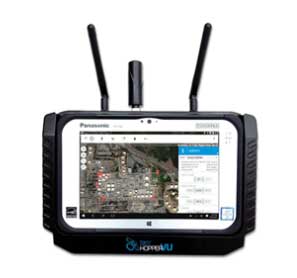
Mobilicom’s SkyHopper VU remote viewing terminal is specifically designed for commercial and industrial drones and robotics. (Photo: Mobilicom) Mobilicom Ltd., a global mission-critical-communications solution provider, will present its SkyHopper end-to-end solutions for smart drones and robotics at the Association for Unmanned Vehicle Systems International’s Xponential 2019 trade show.
According to the company, SkyHopper brings all the key components that turn a drone into a smart drone. The SkyHopper product suite includes communication data links, cybersecurity and encryption that has been validated by the Israel Ministry of Defense and other government organizations; video processing; controllers and viewers.
The product line includes the SkyHopper PRO bi-directional data link, SkyHopper PRO V integrated video processing, SkyHopper ControlAir ruggedized controller and the SkyHopper VU remote viewing terminal.
According to the company, the SkyHopper PRO bi-directional data link delivers long range and non-line of sight communication that supports multiple transmission modes. The SkyHopper PRO V includes a dual-camera input, three camera interfaces, dual built-in video encoders and decoders, and local recording ability. The SkyHopper ControlAir allows users to control a drone or robot, as well as transmit or view a video and data while operating in air and ground missions. Finally, the SkyHopper VU offers a mobile HD video and telemetry receiver terminal for multiple viewers, specifically designed for commercial and industrial drones and robotics.
“We have done our homework in understanding what our customers need in order for their drones to successfully execute their missions,” said Oren Elkayam, CEO of Mobilicom. “As a result, while others focus on offerings for today, we offer solutions also essential for the future survival and scalability of commercial drones of robotics. With proprietary drone cybersecurity and radio technology and a highly experienced customer success team, SkyHopper has maintained a strong base of over 50 customers and counting.”
According to Mobilicom, its goal is to enable commercial drone and robotics manufacturers to increase their chances for success by focusing on their own business objectives, reducing time to market and minimizing resource expenditures.
-
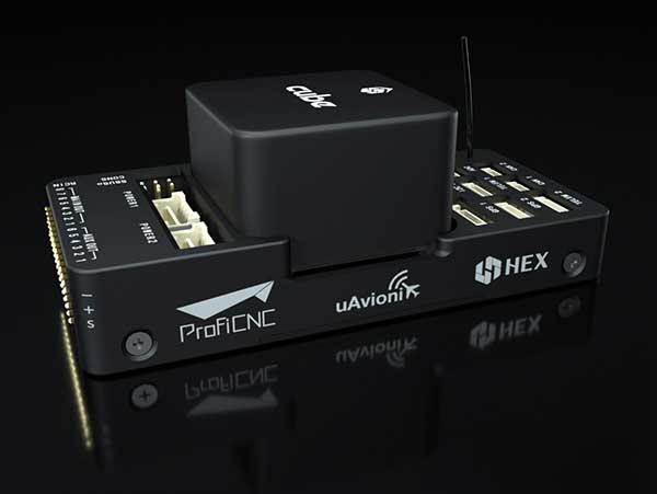
UAvionix partners with CubePilot on ADS-B IN for carrier board
Photo: uAvionix uAvionix has announced a partnership with autopilot maker CubePilot to integrate ADS-B IN receive capability into its carrier board.
uAvionix is the designer and manufacturer of communications, navigation and surveillance (CNS) equipment for unmanned and manned aircraft.
CubePilot is the designer and manufacturer of the “The Cube” autopilot (formerly known as Pixhawk) for unmanned aircraft systems (UAS).
The new carrier board, available in July, integrates uAvionix’s custom ADS-B silicon for 1090-MHz ADS-B reception for worldwide detect and avoid (DAA) functionality.
With this integration, UAS operators will be able to see nearby ADS-B OUT enabled aircraft on ARDUPILOT’s Mission Planner, providing the remote pilot in command (RPIC) with timely notification to take the necessary actions to remain well clear.
CubePilot, which uses the open-source ARDUPILOT platform, previously provided plug-and-play functionality for several uAvionix ADS-B IN and OUT products, including PingRX, Ping2020i and Ping1090i. Support for these products is retained in the new design, allowing for 978MHz ADS-B reception or integration of ADS-B OUT functionality.
“With this partnership, uAvionix furthers our goal of ensuring safety and common situational awareness between airspace users,” states Christian Ramsey, uAvionix president. “We believe that ADS-B IN functionality should be a requirement for every DAA system for UAS operations over people or beyond visual line of sight, and meeting that requirement should not be cost prohibitive.”
“The safe integration of UAS into the National airspace of any country needs to take a safety-first approach from all players,” said Philip Rowse, Hex/ProfiCNC (CubePilot) CTO. “By partnering with uAvionix and including the ADSB-in at practically no cost to the customer, we remove the cost barrier, adding safety to our customers’ UAS solutions.. We envisage this added situational awareness, and optional auto avoidance behavior will be an important step towards safely shared skies.”
Visit uAvionix at AUVSI Xponential in Chicago April 30-May 2 at Booth 4421 and CubePilot at Booth 1816.
-
What’s coming to AUVSI Xponential + UAV misHAPS
AUVSI Xponential 2019 — the huge exhibition and conference built around unmanned everything — will run at the West Building, McCormick Place Convention Center, April 29 to May 2 in Chicago.
This is the premier show for the Association for Unmanned Vehicle Systems International (AUVSI) group and its many members and supporters who have interest in unmanned technology — 8,500 attendees with connection to unmanned and autonomous capability are expected to walk the exhibit hall to see the latest products, hear numerous related presentations, participate in educational courses, and mingle with other like-minded people in the industry.
I was looking for a way to provide a brief overview of the companies exhibiting; a sample cross-section to provide an insight on what to expect. But with more than 700 exhibitors, it’s a difficult thing to do. Then I realized that the company show preview emails in my inbox were from organizations that were actually quite representative of the industry, and I had my overview selection.
Flyability’s drones are adapted for inspection tasks, both indoors and out, with an exterior protective cage. Routine inspection jobs indoors, underground and around complex pipework become quicker, safer and are fully documented by high-resolution video and stills.
This all enables the reduction of costs and process-interruption downtime of industrial inspections, while also reducing to a large degree the risks for inspection professionals. Industries using these inspection drones include power generation, oil and gas, chemicals, maritime, infrastructures and utilities, and public safety.
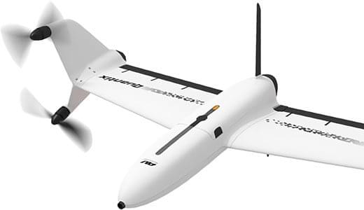
AeroVironment’s drones are used extensively by the military for surveillance and reconnaissance, and in the commercial sector they focus on tools for agriculture.
Quantix drone. (Photo: AeroVironment) The VTOL (vertical take-off and landing) Quantix drone system is fully automated for takeoff, flight and landing, enabling mapping of farm acreage to monitor crop health to identify anomalies due to water, insect, weed and disease so their impact on yield can be minimized.
Valqari has developed a drone mailbox that is interoperable with a large number of delivery drones and enables drop-off of packages in residential neighborhoods.
The Valqari drone mailbox automatically accepts packages and safely stores them until the recipient opens the box later to retrieve them.
Cepton Technologies makes lidar systems more commonly used for automotive obstacle detection, but now customized for UAV integration and use. Its UAV lidar system provides long-range, high-resolution and low-cost mapping capabilities in a lightweight package. With a scanning range of 200 meters, high-density map-data acquisition becomes possible.
Deseret UAS is a non-profit working to bring UAS business to Utah — the organization offers information, promotes UAS companies and offers test-range access in Utah. In collaboration with Utah State University AggieAir, FAA authority for flight testing in wide open; low-risk operational areas of Utah can be accessed.
And, of course, General Atomics Aeronautical Systems (GA-ASI), manufacturer of the well-known Predator military drone, will exhibit. At Xponential 2018, GA-ASI unveiled its MQ-9B SkyGuardian certifiable drone system. Through the year, the company has progressed towards certification of the system for flight within the U.S. civilian National Airspace System and the civil airspace of other countries around the world.
GA-ASI’s latest media release recounted how an MQ-9B was flown by the company’s Certifiable Ground Control Station (CGCS) on March 9, including both take-off and landing. The CGCS architecture separates flight and mission-critical functions. Off-the-shelf avionics and flight computers are used for flight-critical functions, and mission-critical functions run alongside GA-ASI’s Advanced Cockpit payload and weapons equipment.
Meanwhile, High Altitude Pseudo-Satellite (HAPS) unmanned aircraft are back in the news with what appears to be a crash during the sensitive take-off/climb-out regime. The Airbus Zephyr aircraft — with an 82-foot wingspan, but weighing less than 75 pounds — was engaged in a test campaign in Western Australia when the ground abruptly intervened on March 15.
Airbus is working with the UK Ministry of Defence to demonstrate the operational capabilities of the UAV and its anticipated payload options. Once airborne, Zephyr is intended to climb out to upwards of 65,000 feet into the stratosphere — previously achieving a maximum altitude of 74,000 feet — and has so far been able to remain airborne for almost 26 days. The object is to create a commercial, reusable, reconfigurable satellite-like capability for communications and surveillance applications.
Airbus and MoD are undertaking a crash investigation to determine what exactly happened and how to prevent future recurrence. The incident occurred about four hours into a demonstration flight, and (reading between the lines) may have been related to rapid weather changes that destabilized the UAV while in the take-off and climb-out phase. An automated launch system is in the works — currently Zephyr is man-handled for take-off.
Other HAPS programs include AeroVironment and Japan’s Softbank, Astigan and the UK Ordnance Survey, BAE Systems and Prismatic, and Boeing’s Aurora Flight Sciences. Thales, meanwhile, is apparently focusing on an approach using an autonomous airship.
So some good news, some not so good. Lots of attendees are expected in Chicago for the AUVSI Xponential show, with new developments in unmanned aircraft, robotics, and unmanned ground and water systems anticipated in the exhibition hall. There will be lots of people in the industry with whom to exchange ideas and conduct business to conduct, hopefully just as spring arrives in the windy city.
Meanwhile, over the coming months Airbus will no doubt continue to work out how to overcome the latest problems in HAPS technology and operations.
-
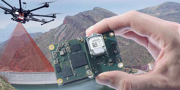
Quanta UAV INS/GNSS improves UAV-based surveying
SBG Systems will present its Quanta UAV series at AUVSI’s Xponential show, which takes place April 30-May 2 in Chicago. The Quanta UAV series is a line of inertial navigation systems (INS) dedicated to UAV-based surveying integrators.
Because SBG Systems wants UAV surveyors to save autonomy for additional survey lines, the company has designed a small, lightweight, and low-power INS offered on two levels of accuracy. Quanta UAV and Quanta UAV Extra have been developed for compact lidar to high-end BVLOS mapping solutions. They provide precise orientation and centimeter-level position data delivered both in real time and post processing. This direct geo-referencing solution eliminates the need for ground control points and greatly reduces the need of overlapping.
Qinertia, SBG’s post-processing software completes the Quanta UAV offer. It gives access to offline real-time kinematic (RTK) corrections from more than 7,000 base stations in 164 countries, the company said. Trajectory and orientation are greatly improved by processing inertial data and raw GNSS observables in forward and backward directions. This advanced software also computes the base station position to quickly provide centimeter accuracy. Qinertia comes free for one year with the Quanta UAV sensor.
Robotics and surveying. Quanta UAV is the result of SBG’s expertise in both miniaturized technology for drone navigation and high-end sensors for mobile mapping. Designed as a geo-referencing solution, it can also be used as a high-end navigation solution to feed the UAV autopilot.
Quanta UAV benefits from a tight integration with in-house IMUs, advanced calibration techniques and algorithms that ensure consistent behavior in all weather conditions, as well as robust position even if the UAV gets close to buildings, electrical lines or trees.
Quanta UAV embeds a web interface for an easy configuration with a 3D view showing all parameters. The calibration tool automatically aligns the lever arm between the two antennas and the sensor, and re-estimates it in flight for more precision.
The ITAR-free Quanta UAV INS are available for order.
Featured photo: SBG Systems