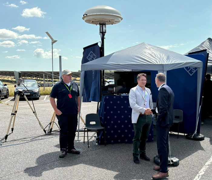
Rohde & Schwarz has demonstrated its latest advancements in counter-drone technology at CUAS Expo 2025 at Thorney Island. The display featured an integrated system that included the ARDRONIS Wi-Fi detection solution and ARDRONIS Locate Advanced localization solution, along with the newly released ARDRONIS Effect configured as a multiband jammer.
At the event, Rohde & Schwarz showcased how its comprehensive counter-drone system detects, identifies and neutralizes rogue drones regardless of their operating frequency. The demonstration showed the system’s ability to manage non-cooperative and non-compliant devices operating outside established regulations.
ARDRONIS Effect in the Multiband Jammer configuration was a key highlight, demonstrating its unique wideband architecture which enables it to simultaneously jam multiple frequency bands, providing unparalleled protection against a diverse range of drone threats. Unlike traditional jamming solutions, ARDRONIS Effect in the Multiband Jammer configuration doesn’t rely on pre-defined frequencies, making it highly effective against drones operating on unconventional or rapidly changing frequencies.
ARDRONIS Locate Advanced complemented the jammer by providing precise drone detection and localization, allowing attendees to witness the system’s ability to quickly identify the location of drones and enable informed response decisions. The integrated system delivered a comprehensive view of situational awareness and robust protection capabilities.
Rohde & Schwarz said it received interest from attendees at CUAS Expo 2025 and had conversations about customer requirements. The company is following up with agencies and CUAS system integrators to discuss potential deployments of the ARDRONIS system.
“Discussions with attendees underscored the growing concern surrounding non-compliant drone activity and the need for adaptable, wideband solutions like ours,” said Christopher Mantle, business development manager for UK Land EW and Communications at Rohde & Schwarz.
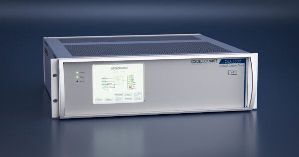
Australia’s Defence Science and Technology Group (DSTG), part of the Australian government’s Department of Defence, has selected Adtran’s Oscilloquartz high-performance optically pumped cesium clock to support research at its Adelaide facility.
The OSA 3300 HP will serve as a time and frequency reference for positioning, navigation and timing (PNT) research. Delivered in collaboration with local partner CoverTel, the deployment marks the first integration of optical cesium technology within Australian defense research.
“DSTG’s selection of our optical cesium reflects a broader shift toward autonomous, long-term synchronization solutions,” said Stuart Broome, GM of EMEA and APAC sales at Adtran. “Defense organizations around the world are reassessing how they ensure timing resilience, particularly as reliance on GNSS becomes more of a risk.”
The OSA 3300 HP will give national infrastructure precision and adaptability, supporting DSTG’s research into new strategies for assured PNT. DSTG selected the OSA 3300 HP to support advanced PNT research within its Sensors and Effectors division.
Using optical pumping technology that measures 100 times more atoms than traditional magnetic cesium clocks, the device delivers outstanding frequency stability and precision, Adtran said. Its all-digital design ensures consistent performance, while its 10-year operational lifespan offers long-term value.
With its compact form factor, robust construction and advanced atomic technology, the OSA 3300 HP provides the reliability needed to support Australia’s evolving synchronization requirements and critical scientific initiatives.
The clock will help DSTG explore new approaches to synchronization and build greater resilience into the Australian Defence Force’s long-term PNT capabilities, especially in contested environments where GNSS jamming and spoofing are prevalent. It will lay the groundwork for systems that rely on precise, dependable timing — from secure defense communications to advanced sensing and navigation.
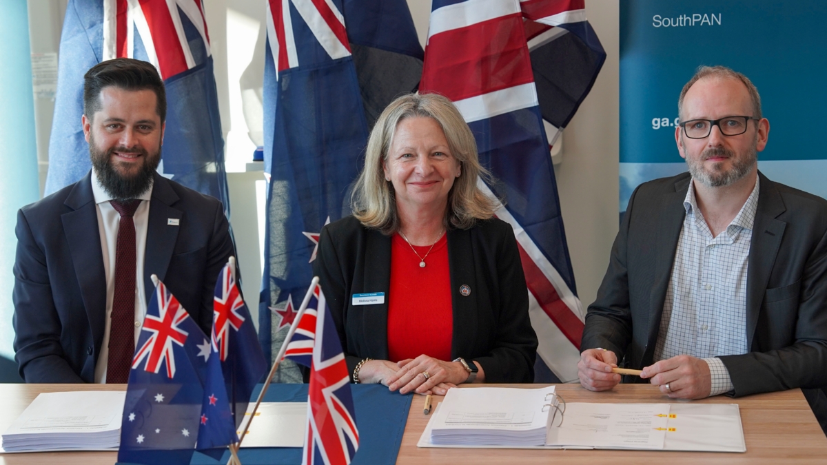
Viasat Inc. has received $252 million AUD from Geoscience Australia and Toitū Te Whenua Land Information New Zealand (LINZ) to deliver additional satellite services for the region’sSouthern Positioning Augmentation Network (SouthPAN).
SouthPAN is a collaborative satellite-based augmentation system developed jointly by Australia and New Zealand. It provides precise positioning and navigation services to support aviation, maritime, agriculture, surveying and emergency response.
This is the second contract award for Viasat, after Inmarsat — which has since combined with Viasat — was awarded a contract in May 2023 to deliver a satellite payload for SouthPAN. The new agreement, which amends the previous award and comes under Viasat’s Communication Services segment, covers the continuation of services from Viasat’s existing in-orbit satellites as well as a new payload, marking a significant extension of Viasat’s partnership with both governments.
The agreement secures satellite service and ground infrastructure to deliver precise positioning across Australia, New Zealand and the region’s maritime zones.
SouthPAN is delivered by Geoscience Australia in partnership with Toitū Te Whenua Land Information New Zealand, with early services available to both countries since 2022.
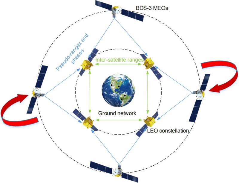
The rotation-corrected integrated POD method holds significant promise for global navigation augmentation, autonomous LEO-based navigation systems, and real-time positioning services.
Modern satellite constellations such as OneWeb, Starlink and CENTISPACE promise global communications and navigation capabilities using low-Earth orbit (LEO) constellations. However, their precise orbit determination (POD) requires dense ground station networks — costly and often limited by geopolitical or geographical constraints.
Inter-satellite links (ISLs) help reduce ground dependence but suffer from “rotational unobservability,” where the entire constellation drifts in orientation due to the lack of an absolute spatial reference. Existing fixes often require additional infrastructure or high-quality GNSS products, which increase latency and operational complexity.
Because of these challenges, a more autonomous, low-latency approach that leverages existing onboard capabilities is needed to ensure reliable, high-accuracy orbits for mega-constellations.
Wuhan University researchers have developed and validated a rotation-corrected integrated POD method that fuses ISL measurements with onboard BeiDou-3 (BDS-3) GNSS observations. Published (DOI: 10.1186/s43020-025-00175-8) in Satellite Navigationon Aug. 4, the study demonstrates how the technique simultaneously estimates the orbits of LEO and BDS-3 medium-Earth-orbit (MEO) satellites, corrects systematic rotation using BDS-3 broadcast ephemerides, and achieves centimeter-level precision.
The approach significantly reduces reliance on ground stations, making it well-suited for real-time applications in large-scale LEO constellations, the researchers said.
The team simulated a 66-satellite LEO constellation equipped with ISLs and onboard BDS-3 receivers, alongside 24 real BDS-3 MEO satellites. Two processing strategies were tested: using BDS-3 data from all LEOs, and from only a subset. In both cases, ISL and GNSS data were jointly processed to form a unified high–low constellation.
Due to internal-only measurements, the initial solutions exhibited significant systematic rotation — up to 40 cm cross-track error for LEOs and over 1 meter for MEOs.
This innovation could become a cornerstone technology for integrating LEO constellations with existing GNSS systems to enhance global navigation and timing performance.
The researchers derived rotation angles between the integrated POD coordinate frame and the BeiDou Coordinate System implied in broadcast ephemerides, then applied a Helmert transformation to correct the orbits. After correction, LEO along-track and cross-track errors dropped from 22.7 cm and 39.3 cm to 1.3 cm and 4.2 cm, respectively. MEO errors fell from over 1.2 m to about 13 cm.
Even when only 36 of 66 LEOs carried GNSS receivers, ISL connectivity propagated the correction across the constellation with minimal accuracy loss. Tests also examined the influence of predicted Earth rotation parameters and residual errors in broadcast ephemerides.
“This method tackles one of the most stubborn issues in autonomous constellation orbit determination — systematic rotation caused by the lack of absolute spatial reference,” said Kecai Jiang, corresponding author of the study. “By harnessing readily available BDS-3 broadcast ephemerides and inter-satellite measurements, we can deliver centimeter-level precision without waiting for post-processed GNSS products or building extensive ground networks. This approach is not only efficient but also scalable, paving the way for real-time, high-accuracy navigation services in future mega-constellations.”
The rotation-corrected integrated POD method holds significant promise for global navigation augmentation, autonomous LEO-based navigation systems, and real-time positioning services. By dramatically reducing reliance on ground infrastructure, it enables resilient operations in remote or geopolitically constrained regions. Its scalability makes it suitable for next-generation satellite constellations supporting broadband internet, disaster response, and precision agriculture, the researchers said.
Moreover, the ability to achieve near-uniform accuracy across all satellites — even when only part of the constellation carries GNSS receivers — lowers hardware requirements and operational costs. This innovation could become a cornerstone technology for integrating LEO constellations with existing GNSS systems to enhance global navigation and timing performance.
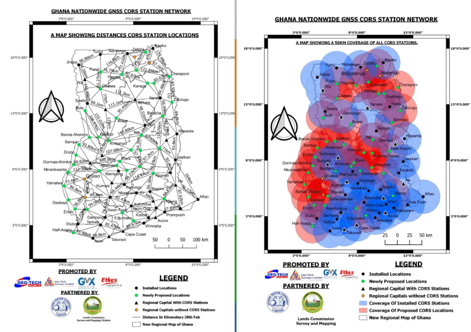
Ghana Lands Commission, through its Survey and Mapping Division (SMD), in collaboration with the Licensed Surveyors Association of Ghana (LiSAG) and GMX Systems Ghana Limited, has launched a nationwide observation exercise for Ghana’s GNSS Continuously Operating Reference Station (CORS) Network.
This initiative is a major milestone in modernizing the country’s geospatial infrastructure and improving land administration.
The exercise aims to integrate more than 60 newly established CORS stations into the national geodetic framework, consolidating Ghana’s Grid Coordinate System. The partners plan to expand the network to 100 stations before the end of the year.
With a modern CORS network, surveyors and spatial data users will have 24/7 access to high-precision data, improved efficiency and cost savings, while aligning Ghana with international geospatial standards.
It will improve accuracy for land records, agriculture, disaster management, infrastructure development, and revenue generation for the Lands Commission. The observation will be rolled out in three phases — Southern, Middle, and Northern zones — to ensure systematic coverage and data management.
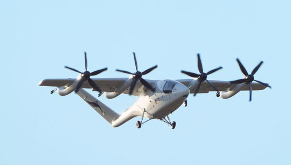
As we are always looking for news on electric vertical take-off and landing vehicle (eVTOL) progress, the United Kingdom has recently stepped up with Gloucestershire-based Vertical Aerospace in the Cotswolds area, a beautiful part of Southwestern England.
The company flew its new VX4 prototype from Cotsword airport to RAF Fairford (a military airport) for the Royal International Air Tattoo (RAIT), one of the world’s largest military airshows. This demonstration marked the first flight between two public airports in the country. The VX4 was also the only eVOTL on display at RAIT.
RAF Fairford, which also serves as a base for the U.S. Air Force in Europe, has hosted aircraft including the U.S. B-52, B-1, B-2 bombers and U-2 reconnaissance aircraft. This year, RAIT featured several hundred aircraft from 30 countries, with around 200,000 attendees.
The VX4 is equipped with eight tilt-and-lift propellers that provide redundancy for takeoff, landing and horizontal flight. The aircraft is designed to carry four passengers and one pilot.
The avionics include proven Honeywell flight controls, and the lightweight airframe is constructed from carbon composite materials. Vertical Aeropspace said the eVTOL is designed to meet the same UK and European certification requirements as existing conventional passenger aircraft.
The VX4 is designed with extremely low noise characteristics in both hover and horizontal flight at up to 150 mph. The company plans to use a hybrid-electric power unit in its production models.
VX4 in flight.(Credit: Vertical Aerospace)
With a range of 100 miles and a max speed of 150mph, VX4 is being touted for short hops to overcome crowded city roads, or in London, avoiding changes on the underground while toting cumbersome luggage, and flying between downtown and one of London’s busiest airports.
The VX4 can be reconfigured to carry cargo and is powered by specially designed batteries built for high output and rapid recharging, enabling quick turnaround for trans-city passenger transport.
While aiming to replace helicopters for short hops over the city, Vertical Aerospace claims the VX4 offers far quieter, less maintenance-intensive and lower operating costs. There has been no mention of autonomous operations at this stage, but with all the necessary capabilities in hand, it’s possible that pilotless, automated flight could be possible at some future stage.
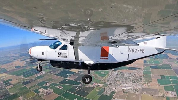
Reliable Robotics (Reliable) has been around since being founded in 2017 – they have the objective of automating flight for General Aviation (GA), passenger airlines and cargo aircraft. Reliable reports that roughly 400 people are killed each year in GA through loss of flight and controlled flight into terrain accidents. Reliable believes that about 70% of issues could be prevented by their automation systems. For airlines, 1397 people died in 75 fatal accidents between 2017 and 2021.
Working with the US Air Force (UASAF), FAA and NASA, Reliable first equipped and flew an unmanned Cessna 172 and later did the same with a Cessna 208B Caravan, similar to those operated by Federal Express (FedEx). In the process, they developed their own detect and avoid (DAA) system and qualified their own actuators to FAA standards. With the intention of developing a certifiable autopilot which would manage taxi, take-off, en-route flight, and landing, Reliable implemented a multiple flight management system which is supervised by a remote pilot.
Unmanned Cessna 208B Caravan (Credit: Reliable)
With the extensive use of simulations, around 140 landings were first accomplished and the third landing of the actual equipped aircraft was fully automated. It may have seemed a little unnerving at first to see the aircraft taxi out to the runway with no pilot in the cockpit!
Nevertheless, it was clear that the system worked extremely well, with a remote voice interface, ground control, data link control, and monitoring of the aircraft system. With over 5000 airports available around the US, only 130 actually experience commercial operations, so the scope of enabling automated cargo transport activity more extensively across the nation appears to have room for expansion.
Reliable has just begun more simulation work with NASA — automated aircraft human-in-the-loop detect and avoid (DAA); loss of the command and control (C2) link and the necessary reversionary recovery systems, and management of the automated aircraft alongside manned aircraft as they both enter and leave airports. Work is intended to figure out the level and type of automated systems required for safe integration of large volumes of cargo-carrying unmanned aircraft systems (UAS) into the National Airspace System (NAS).
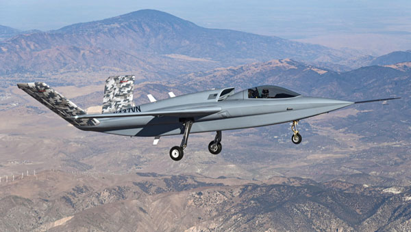
Northrop Grumman had Scaled Composites (SC) build a prototype (Model 437) manned UAV, which, according to the company, is now destined to become a testbed for autonomous systems development.
Now called Beacon, the testbed originally flew in August 2024, possibly as a contender for the Loyal Wingman Collaborative Combat Aircraft opportunity, with a Pratt & Whitney 3400 lb thrust jet engine and an internal weapons bay capable of carrying 2000 lb of weapons. SC originally built the M437 as a platform to demonstrate Northrop’s digitally engineered wings.
Model 437 in flight. (Photo: Scaled Composites)
Now, Northrop is providing the airframe to enable collaborative partners to further develop autonomy capability to be used in future Northrop programs.
Nice to see some VTOL air taxi development in the UK, an outfit focusing on the insides of UAV autonomy and even an aircraft platform for developers to use — all together interesting times for autonomous UAV growth.
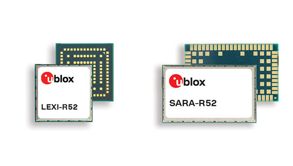
U-blox has entered into a binding transaction agreement with ZI Zenith, a subsidiary of Advent International, for $1.3 billion. Under the agreement, ZI Zenith will launch a public tender offer to acquire all publicly held registered shares of u-blox at a price of CHF 135.00 per share in cash.
Founded in 1997 as a spin-off from the Swiss Federal Institute of Technology in Zurich, u-blox is best known for its affordable and accessible modules that combine microcontrollers, wireless connectivity, and multi-constellation GNSS receivers. Its communications products have also ensured it a slice of the Internet of Things (IoT) market — the company recorded a net profit of SFr101.8 million (around $126 million) in 2021.
“U-blox is a recognized leader in high-performance positioning and short-range communication technology solutions. We are excited about the opportunity to partner with the u-blox management team and co-founders, and support this innovative technology champion through its next chapter of growth,” said Ronald Ayles, managing partner at Advent. “We are deeply committed to invest in the long-term success of u-blox, using our extensive experience and resources in automotive and industrial end-markets to accelerate innovation and expand its global reach. Advent has a long and successful track record of partnering with founders and management teams to deliver sustainable value creation.”
The offer represents a 53% premium to the undisturbed volume-weighted average share price of the last 6 months until August 14, 2025, and a 32% premium to the undisturbed volume-weighted average share price of the last 60 trading days of u-blox shares until August 14, 2025, before the media first reported on a potential transaction.
U-blox’s board of directors has unanimously concluded that the transaction is in the best interests of the company, its shareholders and other stakeholders. It therefore recommends that shareholders accept the offer and has committed, along with the management team, to tender all their shares.
The board’s recommendation is supported by an independent fairness opinion stating that the offer price is fair from a financial point of view. In addition, u-blox’s largest individual shareholder, SEO Master Fund LP, holding approximately 9% of the outstanding shares, has committed to tender all of its shares.
The tender offer is subject to terms and conditions as well as regulatory approvals customary for this type of transaction and is expected to be settled within the next six months. The intention is to then delist u-blox shares from the SIX Swiss Exchange.
The pre-announcement of the offer, which has been published today, is available at www.takeover.ch and www.zenith-offer.com and includes the material terms and conditions of the public tender offer.
Swift Navigation has partnered with Taiwan Mobile, a major telecommunications company in Taiwan, to introduce the Skylark Precise Positioning Service to the Taiwanese market. This collaboration aims to meet the increasing demand for high-accuracy positioning solutions across various industries.
Skylark is a real-time GNSS correction service that enhances positioning precision to the centimeter level by correcting signal errors from GNSS. It is the first cloud-based precise positioning service developed specifically for large-scale applications, designed to deliver accuracy, reliability, and safety worldwide. The service utilizes advanced atmospheric modeling to reduce errors from ionospheric disturbances, clock drift and satellite orbit inaccuracies, improving location accuracy from several meters to just a few centimeters.
The service is supported by a carrier-grade network consisting of modern ground reference stations, which have been designed and operated collaboratively by Taiwan Mobile and other mobile network operators globally. Skylark’s highly reliable and precise positioning capabilities are expected to support emerging applications in automotive, robotics, and fleet management sectors. In automotive applications, it is the first and only automotive safety integrity level (ASIL) certified, real-time cloud-based positioning service compliant with ISO 26262:2018, enabling safe operation of advanced driver-assistance systems (ADAS) and autonomous vehicles.
For robotics, Skylark’s proprietary atmospheric modeling offers centimeter-level accuracy with extended baselines and automatic failover, ensuring reliable performance for devices such as robotic lawnmowers and surveying drones. In fleet management, the service provides a cost-effective, dependable positioning solution optimized for battery-powered devices, facilitating efficient last-mile and final-inch logistics, and integrating with a broad range of compatible GNSS hardware.
GNSS spoofing has become a regular occurrence with the potential for severe consequences when precise and reliable positioning is critical. Legacy GNSS signals are the primary target for bad actors, as most precise positioning relies on these signals, and it’s constantly getting easier and cheaper for people to fake the message. To combat this, Trimble has introduced Trimble RTX-NMA (Navigation Message Authentication), the first solution on the market to mitigate spoofing attacks on the GPS and BeiDou satellite constellations. Trimble RTX-NMA leverages the Trimble RTX correction service and enhances the security and integrity of GNSS navigation messages for all Trimble ProPoint receivers. Used in conjunction with Galileo OSNMA, users now have three constellations protected from spoofing attacks.
Trimble RTX-NMA seeks to detect both fake GNSS signals and faulty ephemeris data through real-time authentication that ensures navigation messages from multiple RTX reference station receivers are genuine and trustworthy. It also encompasses faulty ephemeris detection, preventing unreliable data from being included in the correction stream. Enhanced security through advanced cryptographic techniques like AES encryption, and stream authentication, take it a step further. Trimble RTX-NMA is also compatible with various Trimble GNSS receivers using firmware version 6.40 or greater, making it a versatile solution for a wide range of applications without a subscription. With these features, Trimble RTX-NMA offers increased reliability, enhanced security, and improved integrity — an added layer of defense against potential threats such as spoofing.
As reliance on GNSS continues to grow, ensuring the security and integrity of navigation data becomes paramount. Trimble RTX-NMA represents a significant step forward in addressing these challenges, offering a robust and effective solution for enhancing GNSS security.
JAVAD GNSS, a global provider of high-precision GNSS solutions, and Inertial Labs, a VIAVI Solutions Company, have entered a strategic partnership to integrate Inertial Labs’ IMU-P modules with JAVAD’s advanced OEM GNSS receivers. This collaboration introduces a new GNSS+INS platform designed to deliver accuracy, stability and resilience, even in environments where GNSS signals are weak or unavailable.
Central to this advancement is the JAVAD TR-3Si receiver, engineered for compatibility with professional IMU modules. Combined with the advanced IMU-P units, the system is positioned to offer high levels of precision and reliability, supporting mission-critical requirements in aerospace, defense, autonomous vehicles, UAVs, robotics, precision agriculture and other demanding sectors.
Inertial Labs’ IMU-P modules can perform in dynamic settings, providing continuous orientation and acceleration data for sensor fusion. The integration of this inertial technology with JAVAD’s established GNSS systems enhances navigation accuracy and efficiency in both GNSS-accessible and GNSS-denied environments.
JAVAD GNSS is expanding its support for IMU modules and is expected to release further updates on this initiative.
The Department of the Air Force (DAF) has successfully launched the Navigation Technology Satellite-3 (NTS-3) Vanguard aboard the United Launch Alliance (ULA) Vulcan rocket on the USSF-106 mission from Cape Canaveral Space Force Station, Florida, on August 12, 2025. This mission marks the first U.S. national security payload launched on the Vulcan Centaur rocket, which represents a new era of launch vehicle capability for national defense.
“We have a strategic imperative to deliver science and technology that enables and accelerates a resilient hybrid space architecture for the space capabilities that the joint force depends on,” said Air Force Research Laboratory (AFRL) Commander and DAF Technology Executive Officer (TEO), Brig. Gen. Jason E. Bartolomei.
NTS-3’s Advanced Architecture
NTS-3 is an experimental integrated navigation satellite designed by the AFRL to enhance the robustness, resilience and responsiveness of space-based positioning, navigation and timing (PNT) services, crucial to both military and civilian applications. The satellite aims to advance the capabilities of existing global navigation satellite systems, such as GPS, through innovative technology that includes an advanced atomic clock timekeeping system, a reprogrammable receiver compatible with both legacy and advanced signals (the Global Navigation Satellite System Test Architecture), and Chips Message Robust Authentication, which defends against GPS spoofing.
NTS-3 features a fully reprogrammable software architecture that spans the space-based satellite, ground-based control system, and agile user receivers. This enables rapid software updates either on orbit or in the field, a significant departure from previous GPS satellites that required hardware changes for upgrades. This approach delivers not only military advantages in contested environments but also substantial benefits for civilian users who rely heavily on GPS for banking, agriculture, telecommunications and air traffic control.
“We rely on GPS so much, in ways that we don’t always think about,” said Rachel Gleichmann, NTS-3 deputy program manager, AFRL Space Vehicles Directorate. So, to make sure that it is resilient and that it’s always available and always accurate — or, as the military likes to say, ‘assured’ is extremely important to your average American.”
Industry partner L3Harris Technologies serves as the prime contractor, working alongside AFRL on the design, development, integration, testing, launch vehicle interface, and on-orbit operations of the satellite. The collaboration embodies a comprehensive ecosystem approach that leverages resources from government, industry, academia, and venture capital to foster innovation in national security space.
Anduril Industries is expanding into South Korea, opening a new office in Seoul. The company has also appointed a new local country leader and is forming partnerships with Korean companies to develop defense technologies for the region.
The move coincides with a two-day visit to the Republic of Korea by company founder Palmer Luckey, who is meeting with government officials and industry leaders.
The Seoul office is Anduril’s first in South Korea. John Kim has been appointed vice president and head of Anduril Korea. Kim previously led Boeing Korea’s defense business and served as the company’s interim president. He brings extensive experience working with the U.S. military and South Korea’s defense sector. The company plans to expand its local team and expects to double its headcount within 12 months.
South Korea’s Ministry of Defense has prioritized artificial intelligence, autonomous systems, and networked weapons as part of a modernization effort coordinated by the Joint Chiefs of Staff. Military planners say current defense systems are insufficient to deter or prevail in future conflicts.
As part of the expansion, Anduril will sign a contract with Korean Air’s Aerospace Business Division to co-develop unmanned aerial systems, license production of additional Anduril products for the Indo-Pacific market and explore the possibility of building a manufacturing and production facility in South Korea. The agreement is expected to establish a cooperative defense technology framework in the region.
“Anduril is committed to helping the Republic of Korea in its mission to develop a technologically advanced, highly networked armed force with fewer but more precise platforms,” Kim said. “Our new office and team expansion is further demonstration of this ongoing commitment.”
Founded in 2017, Anduril employs more than 6,000 people and is valued at over $30 billion. The company has delivered advanced defense capabilities to the U.S. Department of Defense, the Australian Defence Force and the U.K. Ministry of Defence. The new Seoul office will expand Anduril’s growing footprint in the Indo-Pacific.