Boundless, provider of open source geospatial software and services, is offering support and interoperability of QGIS 2.8.2 with OpenGeo Suite 4.6, the most recent version of its enterprise geospatial software platform.
Boundless will be discussing QGIS and OpenGeo Suite at GEOINT 2015 at Booth 2094, June 22-25.
QGIS 2.8.2 is the newest version of the open source GIS desktop application. Boundless commercially supports and packages QGIS as part of OpenGeo Suite 4.6, the latest version of Boundless’ leading open source geospatial software stack, powering web, mobile, and desktop maps and applications across organizations large and small. With this release, Boundless certifies interoperability between QGIS 2.8.2 and OpenGeo Suite 4.6 and extends commercial support for the interoperability to all OpenGeo Suite Enterprise customers.
In addition, Boundless announced the availability of several new custom QGIS plugins for Enterprise customers, designed to enhance the usability and functionality of QGIS. This release includes:
MGRS-Tools, which adds support for using Military Grid Reference System (MGRS) coordinates when working with a QGIS map
WebApp Builder, which enables QGIS users to easily build web-based applications
QGIS and OpenGeo Suite Enterprise from Boundless provide open source geospatial software designed for cost-sensitive users who still have advanced mapping and deployment requirements. Organizations with complex Enterprise needs should no longer feel locked in to proprietary software with significant license costs in order to accomplish sophisticated projects, Boundless said.
“Boundless is pleased to extend our support of QGIS as part of our commitment to making geospatial software available and easy to use for all,” noted Ann Johnson, Boundless CEO. “Every day we see more and more evidence of QGIS’s growing footprint, so we remain focused on meeting the demands of our customer base.”
Boundless offers service packages and training to help customers and free users get the most from QGIS and their OpenGeo Suite deployment. Boundless also supports a variety of deployment options, including on-premise and cloud environments such as AWS and Microsoft Azure.,
Remote GeoSystems, Inc., an Esri Emerging Business Partner, has released two new Esri-based Geospatial Full Motion Video (FMV) Inspection & Reporting Solutions: LineVision Esri ArcGIS and LineVision Esri ArcMap Add-In.
LineVision Esri ArcGIS and LineVision Esri ArcMap Add-In are open and versatile geospatial video analysis and inspection data reporting tools for the Esri platform. Both LineVision Esri versions will accept properly formatted video from a variety of consumer GPS video cameras, UAV/UAS platforms, gyro-stabilized camera systems and specialized geospatial DVRs; including the Remote GeoSystems geoDVR.
LineVision Esri ArcGIS and LineVision Esri ArcMap Add-In enables users to geospatially “navigate” a video recording by simply clicking a location along a GPS track positioned over an Esri-based map. As the video plays, a cursor moves along the GPS track, constantly indicating where the current video view was captured. If something of interest is detected in the video, users may pause and capture a geo-tagged still photo from the video.
The software can play up to four geospatially-synchronized videos at once, enhancing the capabilities of modern airborne multi-sensor HD/IR/UV gimbal cameras and terrestrial mobile mapping systems.
In addition to geo-tagged video, LineVision Esri ArcGIS and LineVision Esri ArcMap Add-in also support geospatial positioning of still photos, audio, annotations and any other digital documents. Along with the video, all these media files can be saved as a .geoProject™ file for the ultimate in data portability and simple delivery to clients.
LineVision Esri ArcGIS. LineVision Esri ArcGIS is a “stand-alone” desktop software that leverages the Esri ArcGIS platform to map, analyze and package geospatial full motion video (FMV), photos, annotations, documents, SHP files and raster imagery. It is designed for rapid adoption and ease-of-use so now anyone without GIS experience can easily view this valuable asset location-based multimedia using enterprise maps and imagery provided by ArcGIS for Server, ArcGIS for Desktop or ArcGIS Online. Users do not need to have other Esri software installed.
LineVision Esri ArcMap Add-in. LineVision Esri ArcMap Add-In offers all the same capabilities as LineVision Esri ArcGIS but as a “traditional ArcMap Add-In,” leveraging Esri’s powerful desktop GIS environment. Users will need to have Esri ArcMap software installed.
“Esri customers have been asking for a solution that simplifies post-mission geospatial video analysis and project reporting while leveraging the enterprise GIS capabilities and data available from ArcGIS Online, ArcGIS for Server and ArcGIS for Desktop. We’re excited to see that utilizing the resources available from Esri’s Startup Program, Remote Geo was able to quickly migrate their LineVision software to the ArcGIS platform,” said Kurt Daradics, EsriEmerging Business Group Manager.
“LineVision Esri ArcGIS and ArcMap Add-In are the first of many solutions to align our geoDVR, LineVision and geoProject capabilities with Esri’s technology stack,” said Jeff Dahlke, Remote GeoSystems Managing Director. “Geospatially-intelligent video is now being recognized as a corporate asset that reduces real risks and costs. Offering solutions that leverage Esri is critical as we roll out our enterprise geospatial video management offerings.”
Key features include:
Multi-channel Geo-referenced HD Video Playback
Snap Geo-tagged Still Photos from Video
Use Waypoint Navigator to Quickly Jump to POIs Identified In-mission
Mark Locations with Annotations and Attach Any Document or File
Add Local Shapefiles & Raster Data
Connect to ArcGIS Online & ArcGIS for Server
Add & Edit Documents and Files Right on the Map
Create Portable .geoProject File Packages
Pro & Viewer Editions Available
Both LineVision Esri ArcGIS and LineVision Esri ArcMap Add-In are available in Pro (Professional) and Viewer editions. The primary difference between the two versions is Pro will allow you to create and save information-rich, immersive geoProject reports with all related files, whereas Viewer is primarily designed for viewing and interacting with previously-saved geoProjects.
The world’s clocks will be adjusted by one second on June 30, when a leap second will be inserted into Coordinated Universal Time (UTC), the standard international time scale.
In theory, all UTC clocks should insert a second labeled 23h 59m 60s (the leap second) following one labeled 23h 59m 59s UTC. This is equivalent to having all of the clocks in the world stop for one second at that time, as explained in May’s Expert Advice column.
The financial market has prepared for potential disruptions. The adjustment could present technical difficulties for traders and exchanges, as some computers might not be programmed to account for the adjustment.
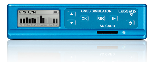
One company preparing is Racelogic, who makes the LabSat simulator. Racelogic will be recording the leap second as it happens and will then have the scenarios available for customers to replay. A variety of recordings will be taken: GPS, GLONASS, and BeiDou constellations will each be captured as a single channel, and also as a simultaneous triple-constellation recording. These will then be available to use with the LabSat.
Jackson Labs has released new firmware versions for various products that address any potential issues for the pending and future leap second events, and that add a number of additional commands to query and handle leap second events.
Precise Time and Frequency, Inc., has published a paper, “Phase Error Correction — Precision versus Speed,” which describes atechnique for rapidly eliminating very large phase offsets (up to 0.5 seconds) between two 1 pulse per second pulses. The change is achieved without a sudden step change (which can be unwelcome in numerous applications) while retaining the ability to tune the phase with high precision (resolution of 0.006 pico seconds) once the large error is eliminated.
“Like many novel ideas, the simplicity of this technique belies its effectiveness,” according to the paper. “With hindsight it seems like an obvious solution; however, the engineering mind is trained to know that to generate a one-second pulse from a reference frequency (in this case 10 MHz), it must be divided by the frequency itself, and the concept of an ‘incorrect’ divisor is not necessarily so obvious. In this case, however, the technique provides an ideal solution that reduces the phase-lock capture time from something that would be intolerable to a very acceptable time period.”
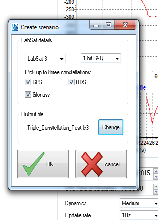
SatGen v3 software is now available for the LabSat GNSS simulator by Racelogic. Version 3 includes BeiDou (BDS) in addition to GPS and GLONASS.
SatGen is billed as a powerful and intuitive software package that gives users the ability to create scenarios for replay through any LabSat simulator. The software creates either user-generated or imported trajectory files for use with a LabSat simulator.
The addition of the BeiDou B1 signals means that users can now test a device’s effectiveness as if it were being used within the operating area of the Chinese constellation, which at present only provides full coverage in Asia.
The BeiDou constellation is set to become globally operational by 2020. With the new SatGen v3, users can create scenarios that include signals from satellites yet to be launched, so new products can be developed in readiness for the full constellation.
SatGen v3 can produce scenarios with one, two or three sets of signals being simultaneously output: GPS, GLONASS and now BeiDou. The software now matches the record and replay abilities of the LabSat 3 simulator.
A trial of SatGen is available here. To purchase a full copy contact a LabSat distributor.
A little more than a year ago, I became a part of a team of surveyors from across the country to offer testing and input on new technology and programing coming out of JAVAD GNSS. It has been a great honor to work along with Dr. Javad Ashjaee, the other surveyors and Javad’s staff at JAVAD GNSS. Why Javad chose me, I doubt that I will ever know. While I am proud to be a part of what Javad has dubbed “J-Team,” I have realized very quickly how little I know about GNSS. In this series of articles that I plan on putting together, I will chronicle my advances in GNSS and testing of JAVAD GNSS equipment.
As part of my testing, I have been using a JAVAD Triumph 2 base (with 4-watt external radio) and a TRIUMPH-LS rover. I had seen advertisements for this system for many months prior to becoming a member of the J-team. I was apprehensive at first with the difference in the appearance and learning the new software. However, it did not take long to realize how advanced this system, namely the TRIUMPH-LS, was.
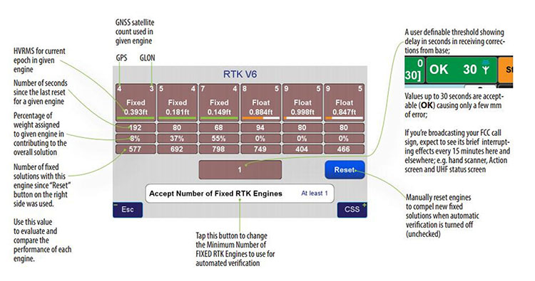
One key feature that I use to determine the quality of my shots is the V6 engines. The V6 engines that it uses to fix the ambiguities is unlike anything I have seen in any other software or receiver. The V6 engines are six separate RTK engines running simultaneously. Basically, this is like having six separate receivers in one.
When in heavy multipath area, I tend to stay fixated on this screen. Each engine can fix at different times. When another engine gets fixed, the resulting epochs are averaged between the two fixed engines and so on with any of the other engines. (See above image.)
This is only one of many technological advancements that Javad has included in his newest receivers. Please continue to follow my articles on other advancements and general surveying practice topics.
For more information on Javad’s J-Field software, the TRIUMPH-LS or other JAVAD GNSS solutions, please feel free to visit www.javad.com, email [email protected], or call 1-888-550-5301 or 1-408-770-1770.
Matthew D. Sibole is a Professional Land Surveyor (PLS) and a member of the JAVAD GNSS J-Team.
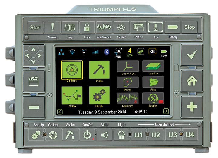
The TRIUMPH-LS and its field software, J-Field, have many revolutionary and innovative features compared to current GNSS systems. Here is a quick overview of its most salient features, making it an ideal unit for surveyors in the field and managing from the office.
The TRIUMPH-LS contains everything needed to function as a complete RTK rover in one small, compact, ergonomic and very portable unit:
an 864-channel GNSS receiver
a UHF or spread spectrum radio, a GSM modem
a Wi-Fi adapter
two internal cameras
a flashlight
a bright 800 x 480 pixel display.
Also included with the system is a collapsible monopod rover pole which allows the unit to be quickly folded up to fit in a very small space, perfect for carrying the system in the field or quickly stowing inside a vehicle. The lack of a data collector bracketed to the rover pole further increases its portability; the user can carry the system through the woods without having to worry about an extruding data collector getting caught in brush.
This system was ergonomically engineered; the head-height vertical display allows the user to operate the TRIUMPH-LS while standing in an upright position and looking forward. Users do not need to bend their neck to look down to view the display, as is traditionally done with a system having a data collector attached to a rover pole. This Triumph feature allows the system to be used without the neck soreness that can plague a user after working for extended periods of time.
The TRIUMPH-LS contains a built-in compass and tilt sensors. The compass enables quick and efficient stake-out of points. Forward/back and left/right offset readings relative to the face of the display show precisely where the stake-out point is located. This stakeout method reduces the time required for this task, compared to using traditional north/south and east/west offsets. The built-in tilt sensors can be used in lieu of having to plumb the rover pole. Taking advantage of the tilt sensors is also a “Lift & Tilt” mode that means topo points can be collected without pressing any buttons. In this mode, when the TRIUMPH-LS is plumbed, a point will automatically start collecting and can be programmed to collect a set number of epochs or to stop collection when the unit is tilted. After the point is collected, the user tilts the TRIUMPH-LS and walks to the next point, which will be collected when the unit is plumbed again.
Software. The field software, J-Field, is included at no extra charge with the system. There is no need for an external data collector or software. J-Field is constantly being improved, and updates will always be available free of charge with the system. The updates can be downloaded through Wi-Fi and are very simple to install, requiring only a couple of button presses to update the system.
J-Field features six separate, parallel RTK engines that all run simultaneously with separate assumptions. This allows for fixes to be obtained quicker than if only a single RTK engine were used. It has an advanced RTK verification system that can be used in difficult RTK environments where there is high multipath and/or tree canopy cover. This process will automatically reset the RTK engines and eliminate points from being collected with bad RTK fixes that often plague other systems in difficult locations.
With the built-in GSM modem, it is very easy to connect to real-time networks (RTNs). Alternately, it can also be connected through Wi-Fi using a mobile hotspot.
Full CAD features are in the process of being developed for use with the map screen. The ability to draw lines, polylines, circles and arcs will be supported. Using the planned move, copy, offset and rotate commands, much of the same CAD work that is traditionally done in the office will now be able to be completed in the field. This very beneficial feature can reduce the number of return visits to a project site.
J-Field has many customization features that can be used to increase productivity as your knowledge of the system grows. The stake and collect screens have eight white boxes that are easily customized to display a number of fields that the user may desire.
Drone experts will join with those from the medical field in a demonstration July 17 in Wise, Va. The event, “Let’s Fly Wisely,” aims to show how unmanned aerial systems (UAS) can alleviate the problem of health care access while creating economic opportunity for communities.
Many people in Virginia and across rural America are beyond reach of essential health services and basic supplies, ranging from bandages to medicine, according to event organizers. The drones will deliver essential medical supplies to an annual medical clinic held at the Wise County Fairgrounds every summer, organized by Remote Area Medical (RAM) USA and the Health Wagon.
At the clinic, thousands of medical specialists provide free eye, dental and health care services to people in urgent need, in what event organizers say is the largest free health care outreach in the nation.
The UAS used for the demonstration will be a completely autonomous rotorcraft, designed by Flirtey, capable of delivering small payloads of drugs and medical equipment to isolated areas, and a larger, fixed-wing aircraft operated by NASA Langley Research Center, capable of carrying up to 600 pounds of cargo.
The most urgent prescriptions will be provided from pharmacies located out of town, reports Startup Daily. To get the medicine to the community as soon as possible, the pharmacies will deliver them to their local airport, where they will be collected by NASA’s fixed-winged aircraft and flown to Lonesome Pine Airport. When the prescriptions arrive there, they will be loaded onto Flirtey drones and delivered to the Wise County Fairground. Flirtey drones are expected to deliver around 24 packages of prescription medication.
The FAA-approved research flights will put UAS technology to work for medical relief, to show how unmanned aircraft can help health professionals provide care more easily and efficiently, closing the gap between those who can offer medical help and those who need it most.
“In doing so, we will demonstrate the promise of a technology that offers a bright future for our youth — right here in Virginia, where Wise County is rapidly becoming a center for technology manufacturing and testing. We believe Let’s Fly Wisely is much more than a novel use of technology in healthcare. It is an example of the self-reliance, ingenuity and wherewithal of the American people and Virginians in particular,” organizers said.
The collaboration includes nonprofits, universities, corporations and government organizations, including Virginia Tech Institute of Critical Technology and Applied Sciences. The Federal Aviation Administration selected Virginia Tech in December 2013 as one of six national test programs to conduct research on integrating unmanned aircraft into the nation’s airspace.
Other partners include:
The Appalachian College of Pharmacy
Flirtey, Inc.
Health Wagon
The Mid-Atlantic Aviation Partnership
NASA Langley Research Center (pending approval of the Space Act agreement between NASA Langley Research Center and Virginia Tech)
Remote Area Medical
Rx Partnership
SEESPAN, Inc.
Wise County Economic Development
The video below shows how Australian start-up Flirtey delivers packages with its drones.
The narrow streets of the historic city of Prague. (Photo by Eric Gakstatter)
I’ve spent the past couple of weeks running around in Europe working on some GIS and GNSS projects. I usually travel outside of the USA two or three times a year to Europe or other destinations. For me, probably the single greatest challenge while traveling outside the U.S .is mobile phone connectivity. I don’t think I travel enough to justify an international plan. I’m probably a bit too cheap and could justify it, but I also sort of like the challenge. When I was in Prague, Czech Republic, last week, I sent the following tweet:
“If u want a reminder of what a great productivity tool ur smartphone is, go 2 where it doesn’t work n see how much time u spend on logistics”
Please excuse the abbreviations and general butchering of the English language, but staying within 140 characters can be challenging when trying to make a point. The point was clear in the tweet. Your smartphone is a tremendous productivity tool. If your life is anything like mine, you’re trying to get from one place to another as efficiently as possible, coordinate with colleagues, and generally optimize your time. Texting, emailing and navigating (directions) are three key components in keeping my life running smoothly, especially when I’m in an unfamiliar city. Further complicating things is when I’m in a city where English is not the primary language and where street signs and other directional help is little or no help.
Primarily through periodic moments of desperation, I’ve discovered some tools and methods that have helped me in some tight spots when I had to be somewhere and my smartphone wasn’t connected to its familiar Sprint towers (BTW, Sprint doesn’t operate in any country other than the USA).
When I find myself outside of the U.S. and want to light up my Sprint Samsung Galaxy 5, the first order of business is finding a Wi-Fi hotspot. In the U.S., it’s pretty easy. In other countries, it’s not so easy and most of the time they want to charge you for Wi-Fi access. Whenever I book a hotel room, I always make sure offers Wi-Fi service.
Skype for iOS, Android, Windows.
If your smartphone isn’t connected to a wireless network (sans Wi-Fi), you can’t send text messages. The best way (and most universal) to solve this is by installing Skype on your smartphone. Skype is free universal messaging software for your smartphone that allows you to call any other Skype user in the world for free, as long as you have an Internet connection (Wi-Fi). Of course, Apple has its own messaging software, but Skype is cross-platform. It runs the same on iOS, Android and Windows phones, as well as desktops. You can also run conference calls and video calls. I use it every day, more so on my notebook computer than smartphone, except when I’m traveling somewhere without wireless coverage (such as Prague). Then I use Skype a lot on my phone, mostly the messaging function. It’s just like text messaging.
With Wi-Fi + Skype, I can call any other Skype member in the world for free, and the app is free. Now, I pay Skype ~$130/year to be able to call any landline in North America from anywhere in the world, so I make free calls home from anywhere. It’s a powerful combination.
Triposo Main Screen
My second favorite smartphone tool for international traveling is not Google Maps, but a rather unknown app called Triposo.
Triposo is designed to be an app for the leisure traveler, but it’s a powerful app for the business traveler. There are Triposo apps for countries and even for individual cities. The apps are huge in size (100+ MB) for each city or country, so it’s not practical to download every city and country app. When I arrive at an unfamiliar city outside of the U.S., one of the first things I’ll do is download the Triposo app for that city using the hotel Wi-Fi.
From a business perspective, there are two things I love about Triposo. First, the download includes a map of the city that you can access offline. This is very similar to how the navigation system works in your car. The app uses the GPS receiver in your phone and plots your location on the map. Sometimes, knowing precisely where you are is half the battle. While it doesn’t have turn-by-turn navigation functionality like your car navigation system, it will provide you navigating instructions in text form and show you where you are on the map and where you need to go. As you move, your location is updated on the map in real-time. Crude, yet very effective.
Triposo Map screen. The purple icon is the GPS position.
Secondly, Triposo is a great tool for finding nearby restaurants and other places of interest. Sure, you can use Google for this too, but Triposo serves up this information a lot quicker and with less fumbling than Google Maps does. Since Triposo is built for the leisure traveler, it also provides interesting information about local landmarks, bus and subway routes, as well as plenty of other useful information for efficiently moving around the city.
My third travel tool is Google Maps. While it groans and chokes when the wireless connection is slow, and it doesn’t do well with the lack of connectivity, it has saved my behind at least once. I was on a project in the boonies in another country, about an hour from a large city where I was going to drop the rental car and board an airplane to come home. When I’d picked up the rental car, I had a local person with me who provided me directions to the project site. However, on the return trip, no one was available to ride with me. I thought I’d “wing it” and figure it out myself. I looked briefly at Google Maps in the office to estimate about the time I would need to exit as well as the exit name. I knew I wasn’t fully prepared with detailed directions, but I thought I had enough information to complete the journey even though Google Maps said something about the maps in the area possibly not being accurate.
I began my journey towards the city (pop. ~5 million). As expected, it was uneventful for the first half hour of the journey, since I was only following the main freeway. Then it became complicated. Lots of Y intersections, lots of speeding traffic, lots of exits, and lots of signage I couldn’t interpret quickly enough while moving along with the traffic. At some point, I figured out that I missed my exit and was heading for the city center. Not good, and approaching rush hour. If you’ve ever been to a large city in a developing country during rush hour, you can get hung up for a while.
I found an exit and was able to switch directions, now heading the opposite direction, southbound. I figured I would go south of the exit I was supposed to take then head northbound again and pay more attention to catch the exit. Nothing. I didn’t see the exit name I was looking for and was again heading towards the city center. At this point, I was becoming concerned. While I’d left myself a bit of a time buffer, by the time I found myself heading towards city center again, my time buffer was nearly exhausted. So here’s where I’m at:
No GPS navigation system in the car.
No mobile phone service so I could call the office for help.
No Internet connectivity to take a fresh look at the directions.
Can’t speak the local language.
For some reason I don’t recall, I booted up Google Maps on my mobile phone to see if I could derive any valuable information from it. Viola!
I learned about a valuable feature (the hard way) in Google Maps. It saves a cached map of your previous actions (not sure how far back). It just so happens that I had been looking at Google Maps on my phone at the airport when I rented the car about a week earlier. I also saw that if I turned on Location Services on my phone, my GPS location was displayed on the map. Granted, without connectivity I couldn’t zoom in on the map and it wouldn’t give me turn-by-turn directions, but I could see my position move on the map as I drove along the highway so I knew where I should be exiting (which, by the way, wasn’t named anything close to what I had read on the map during my preparation at the office).
Now, maybe I’m a slow learner, because when I mentioned this to some colleagues, they exclaimed “Oh, yeah, I knew that.” And, since my experience (I think), Google has provided a method of downloading maps for offline use. Or, it’s possible it was already there but I didn’t understand how to use it. :-(
So, those are my foreign country road-warrior tools. They may not be pretty, but they are free and effective. By the way, Google Navigator really isn’t that good for navigating in cities. Even with GPS and GLONASS satellites being tracked by my Samsung Galaxy 5, urban canyon drives it nuts. Although Triposo didn’t have as fancy of a navigation interface or street-level resolution, it is much less flaky in urban canyon environments than Google Navigator is.
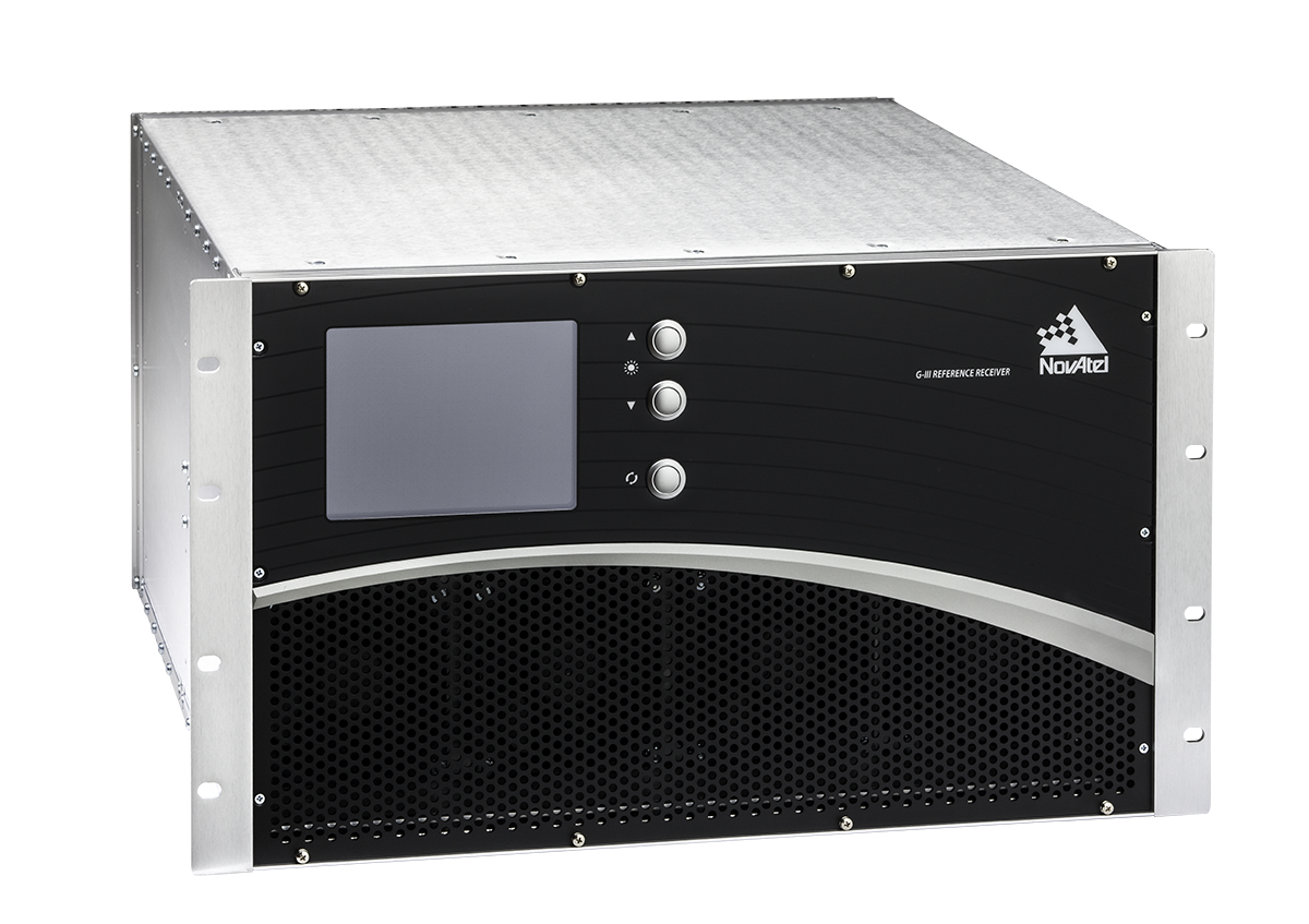
NovAtel Inc. has entered an agreement with NEC Corporation to supply reference receiver products for use in the Quazi-Zenith Satellite System (QZSS). QZSS is Japan’s regional satellite-based augmentation system.
The NovAtel receivers to be used by QZSS are based on the company’s third-generation (G-III) family of reference receivers. Designed for integrity monitoring and reference measurement applications, the receivers track signals independently to provide precise code- and carrier-phase reference measurements as well as signal quality measurements and other integrity monitoring metrics. Housed in a 19-inch rack-mount enclosure with AC power supply and integral cooling fans, the G-III reference receivers provide continuous, reliable operation in a reference station environment, NovAtel said.
The G-III receiver platform has been customized to meet the needs of individual satellite networks. In addition to the QZSS G-III product, NovAtel supplies WAAS G-III reference receivers to the U.S. Federal Aviation Administration’s (FAA’s) modernized Wide Area Augmentation System (WAAS) network and IRNSS G-III reference receivers for the ground control segment of the Indian Regional Navigation Satellite System (IRNSS).
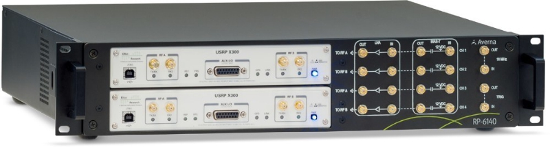
Averna has launched an RF tool offering high-performance record-and-playback and real-time simulation in one platform.
The Averna RP-6100 series is a self-contained, record-and-playback solution for RF application validation. It can capture all GNSS bands, as well as HD Radio, Wi-Fi, LTE, radar, and cognitive radio — plus impairments — to significantly advance RF projects and harden product designs. The RP-6100 series features up to four channels, 160 MHz of recording bandwidth, tight channel synchronization, an extended frequency range of 10 MHz to 6 GHz, and 14-bit resolution.
The RP-6100 can also be equipped with Skydel Solutions’ software-defined, real-time GNSS simulator, which delivers easy setups, integrated maps, dynamic scenario creation, high precision and tight parameter controls to enable highly repeatable simulations of current and future GNSS conditions, as well as corner cases.
Features include:
Frequency range of 10–6000 MHz, covering all GNSS bands, plus HD Radio, WiFi, LTE, and more
Multi-channel (1-4): Up to 160 MHz of bandwidth at 14-bit resolution (< 1 Hz)
3.8 TB SSD storage or 16 TB HDD storage (for up to 22 hours of recordings)
Preloaded with RF Studio software for quick setups and in-depth analysis
Four models: RP-6120 (2 ch.), RP-6120P (2 ch. portable), RP-6120D (2 ch. desktop) and RP-6140 (4 ch.)
Optional real-time Skydel GNSS Simulator for complete GNSS corner-case/testing scenarios
“We are very excited to partner with Skydel Solutions as a way to continue to provide our customers with the latest technologies and products,” said Benoit Richard, VP of Innovation & Strategy at Averna. “Their technology maps perfectly with our portfolio of RF instrumentation solutions, which empower device manufacturers to efficiently generate, record, simulate, analyze, and play back all common radio, video, and navigation signals, ensuring complete test coverage and the highest quality for their RF products.”
“Today, Skydel is proud to introduce its software-defined GNSS Simulator, running in real-time Ettus and NI USRP hardware,” said Stéphane Hamel, co-founder and CEO of Skydel Solutions. “We are also very pleased to announce that our GNSS Simulator can be combined with Averna’s RP-6100 Series. These technologies complement each other perfectly, making the combined solution the ideal platform for high-performance design validation of RF and GNSS devices.”
When the new Extell luxury high-rise building goes up at 217 West 57th Street in Manhattan, the vertical alignment of the core-wall structure will be crucial to success. This internal core structure will rise almost 1,500 feet above the ground and will be the reference for all other building construction, making its construction one of the most mission-critical aspects of the entire project, according to Leica Geosystems.
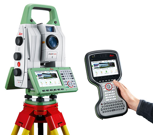
Pinnacle Industries, the concrete contractor responsible for building the structure, has invested in an innovative core-wall alignment system. Consisting of advanced GNSS and robotic total station solutions, the Vertical Alignment System from Leica Geosystems will be used as each floor is constructed to ensure the overall vertical geometry of the structure. High-end training from Leica Geosystems will provide the support and knowledge transfer needed to achieve successful adoption of this innovative approach.
The project is noteworthy for a number of reasons. With an overall roof height of 1,479 feet (1,775 feet to top of spire), the new building will dominate the Midtown skyline and will be the tallest residential building in the world. It will also mark the introduction of Nordstrom Inc. to New York City. The architect of record, Adrian Smith + Gordon Gill Architecture, is the firm behind Dubai’s Burj Khalifa, the tallest commerical building in the world.
According to David Rutledge, director of structural monitoring for Leica Geosystems’ Monitoring Solutions business in North America, Pinnacle Industries chose the Leica Geosystems Vertical Alignment System for its ability to reliably and quickly make alignment adjustments to the forming traveler that will be used to construct each floor. The Leica GM10 GNSS instruments in particular were chosen for their ability to produce highly accurate 3D position coordinates.
“It’s very exciting to be involved with the soon-to-be tallest residential building in the world,” Rutledge said. “Pinnacle is an industry leader in this type of construction, and we feel honored to have been selected by the team. Leica Geosystems’ solutions provide exceptionally high accuracy and outstanding performance, making them ideally suited for the high productivity demanded on projects like this. We’re thrilled to be able to play a supporting role in this significant and historic project.”
GeoLearn, a company focused on serving the geospatial industry with video-based online learning and continuing education credits, has added nine courses on geodesy topics by retired NGS Chief Geodetic Surveyor and GPS World contributor David Doyle.
Doyle is a contributing editor for survey to GPS World’s monthly Survey Scene newsletter. His first column appeared in May.
GeoLearn’s new introductory geodesy courses carry approval for professional development hours (PDHs) from the ABET-accredited geospatial program at Texas A&M University-Corpus Christi.
“I’ve been addressing groups of surveyors and other professionals who use NGS data. In these courses, I take those decades of interaction and try to anticipate and address the most common problems they’ve encountered and most of the questions they would ask,” Doyle said.
Doyle’s first eight courses are offered as a series, though students can pick and choose. The first is an introductory stage-setting course on geodetic fundamentals for those who have been hesitant to delve into any geodesy-related topic. It is an excellent primer for a broad spectrum of geospatial professionals and technicians in fields such as land surveying, engineering and technical GIS applications. The rest of the series includes two on classical horizontal datums and contemporary horizontal datums and two on vertical datums. He includes an additional course on future datums and another on coordinate systems.
Doyle’s ninth course uncovers the “secret sauce” to understanding and using NGS data sheets. It helps novices and experienced alike to understand all the clues and guideposts embedded in such sheets. He includes a discussion of how to understand the accuracy (horizontal and vertical) of various marks based on the metadata provided right in the data sheet. Also included is information on how to access photographs of the marks and how you can update the information using a simple program that you can download from the NGS website.
“Dave was of phenomenal service to geospatial professionals when he was with NGS,” said Joe Paiva, CEO of GeoLearn. “We are proud to be the only 24/7 education source that delivers Dave’s quality, video-based education on these needed topics.”