Blog

  • Use of GIS and Social Networks Help Fight Colorado Wildfires

    Predicting where a dangerous wildfire is going to start can be very difficult, but geographic information systems (GIS) can quickly analyze geographic data about fire-contributing conditions to aid in effective wildfire planning and prevention.

    “GIS is an ideal technology to predict the characteristics of a wildfire because it excels at analyzing multiple data layers,” said Gabe Schmidbauer, GIS professor at American Sentinel University. “The complex nature of wildfire dynamics requires the analysis of multiple disparate datasets such as housing, vegetation and weather for wildfire planning and prevention and can help predict when the current conditions are right for a wildfire.”

    That’s been the situation recently in Colorado as more than a dozen large fires burn in four national forests and eight other areas.

    GIS Impacts Communities

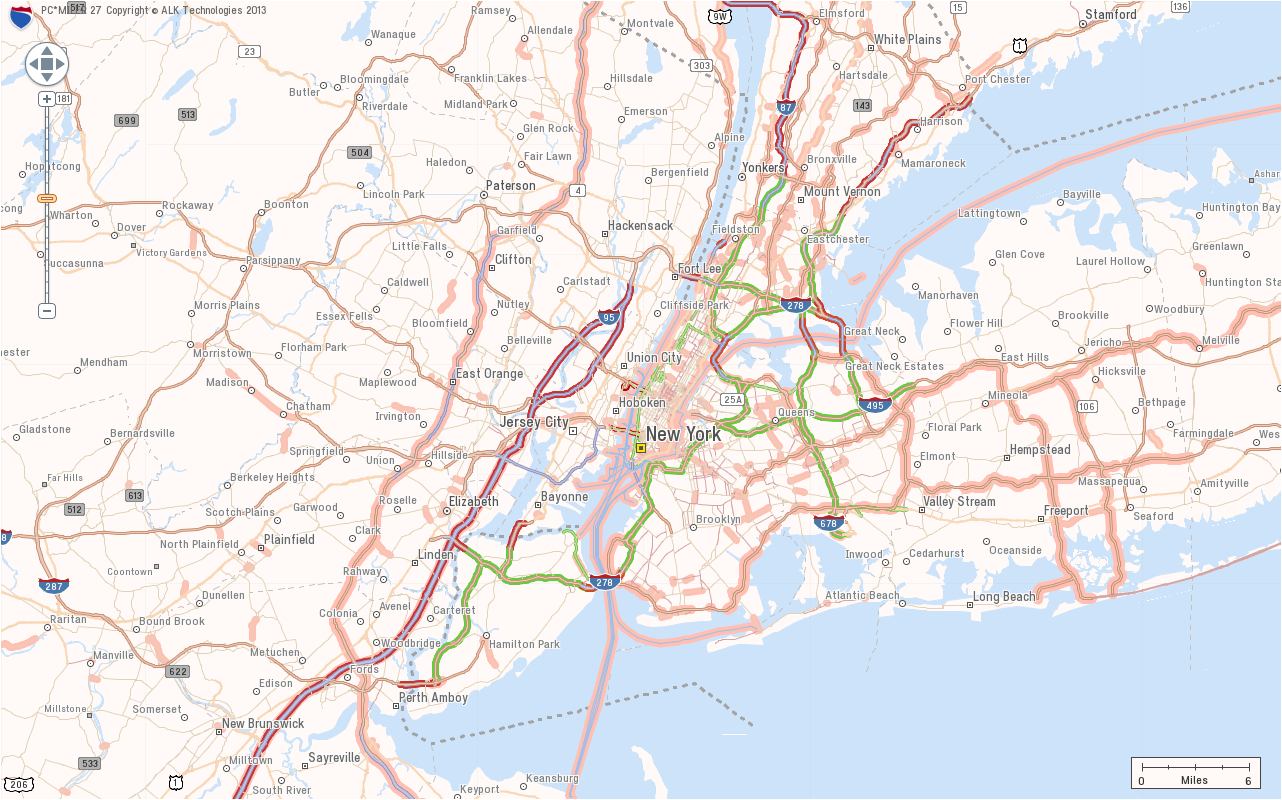
    Recently, a major online GIS mapping system was created to show the precise extent of the burning by GIS software vendor Esri to help residents, firefighters, emergency response workers, officials and others interested in the situation on the ground. It demonstrates how GIS experts can have a major impact on their communities.

    “As GIS analysts model their prediction of wildfire behavior, they simulate changes in fire direction, intensity and geographical extent of a burned area over time to help predict where a potential fire will occur, as well as where a current fire will spread. This gives officials a leg up in fire prevention prediction analysis,” said Schmidbauer.

    Esri’s map system scrolls in or out to cover the area the user wants to see. Pull back and you notice that not only are there the well-publicized problems in Colorado, but large fires in California, New Mexico, Arizona, Utah and Idaho.

    Social network hotspots are also included on the map. Click and you can see relevant data pulled in, including a list of items needed in a particular area.

    There are also other helpful annotations. For example, the map shows current wind patterns, color-coded to show strength. Wind is an important factor in how fires develop. The information can help predict how they might spread, which will affect firefighting efforts and the decisions made by officials and residents of the potentially affected areas.

    Schmidbauer says this analysis is important to help let people answer important questions, such as: Should you head for safer ground? Is it too soon to pull out and possibly leave property, pets and belongings without supervision?

    Users can choose to see which layers of information appear on the map, including U.S. Geological Survey wildfire activity, topographic maps and National Oceanographic and Atmospheric Administration red flag warnings.

    There is also a choice of base maps, over which other data is displayed. They include street, topographic, and terrain maps. In addition, users can separately display sources of images from Flickr or YouTube videos as well as messages from Twitter to develop the real time development of the wildfire.

    “All this information can be invaluable when you’re trying to save someone else’s life or your own,” said Schmidbauer. “And it is all made possible through the power of knowing how to apply GIS to problems in society, non-profits, or business.”

  • ALK Releases PC*MILER 27 with Redesigned User Interface

    ALK Releases PC*MILER 27 with Redesigned User Interface

    New York Map in Smooth Map Style

    ALK Technologies today released the latest version of its PC*MILER truck routing, mileage and mapping software. PC*MILER 27 features and enhancements include a completely redesigned graphical user interface for maximum efficiency and hours-of-service compliance tools for more precise arrival and delivery time estimates.

    “PC*MILER 27 is a milestone for ALK. We’re thrilled to unveil this robust yet easy to use interface with an all new look and feel,” said Mike Bodden, Senior Vice President of Technology, ALK Technologies. “The new UI provides an improved user experience with easier product navigation, resulting in increased productivity.”

    The new PC*MILER 27 graphical user interface reflects recent trends in software design that result in more intuitive navigation of the product’s vast feature set. The user interface features a ribbon-style design with newly crafted descriptive icons, a more accessible layout for smoother transition between tasks, and windows that can be floated outside the PC*MILER application to better accommodate workspace needs.

    PC*MILER 27 features new hours-of-service compliance tools to help ensure that routes and ETAs will accurately reflect drivers’ available hours. The HOS compliance tools increase the precision of arrival and delivery time estimates and help dispatchers and drivers comply with HOS government regulations. Based on remaining hours, PC*MILER calculates when a driver needs to break, and indicates the designated breaks in the detailed driving directions report, automatically updating on-duty hours. Through the PC*MILER|Connect interface tool, fleets are able to import or export the drivers’ remaining hours associated with specific routes. With the pending new regulations, this is crucial to managing driver compliance and CSA safety scores.

    RouteSync is a powerful capability that ensures operational consistency between dispatched routes and actual routes, delivering the guidance to drive the miles that are being billed. With RouteSync, routes and preferences are sent from PC*MILER in the back office directly to the latest version of ALK’s CoPilot Truck navigation software in the cab. In addition to maintaining route compliance, RouteSync reduces non-revenue mileage, improves load profitability and increases driver satisfaction.

    Enhanced routing, map data and address matching are a major part of each annual PC*MILER release, ALK Technologies said. As part of ALK’s ongoing effort to track nationwide toll costs in the U.S. and Canada, PC*MILER|Tolls 27 includes four new toll discount programs.

    The comprehensive suite of PC*MILER 27 integration tools has also been updated and enhanced. PC*MILER interfaces with all leading transportation, logistics and fleet management systems. These products include PC*MILER|Connect, PC*MILER|TCP/IP, PC*MILER|Mapping, PC*MILER|Spreadsheets, PC*MILER|BatchPro and Multi-Version Switch.

    PC*MILER runs on Microsoft Windows, UNIX, and Linux platforms, as well as IBM AS/400 (iSeries) and mainframe computers. PC*MILER is also available as a web-based application.

  • Google’s $1.1 Billion Purchase of Waze Under FTC Scrutiny

    Google’s $1.1 Billion Purchase of Waze Under FTC Scrutiny

    Kevin Dennehy
    Kevin Dennehy

    In a year of ho-hum location deals, or the lack of any, the recent Google purchase of Waze for more than $1 billion is a big one. In fact, readers of GPS World magazine’s LBS Insider would have to go back to the summer of 2007, when TomTom purchased Tele Atlas and Nokia bought Navteq, to find an industry acquisition as big as this one.

    The Federal Trade Commission is reviewing Google’s $1.1 billion acquisition of Israel-based mapping startup Waze, according to published reports.  The big issue is that while Waze’s revenue was too low to trigger automatic review by the FTC, it may have hundreds of millions of users worldwide.

    The fact that Google’s acquisition of Waze has caught the FTC’s attention is not unusual, said Mike Dobson, TeleMapics president, who authors a location industry blog at www.telemapics.com. “Google, in an attempt to speed the acquisition, declared that the assets of Waze based in the United States are worth less than the $70.9 million that requires an antitrust review. Google maintains, and I agree, that the majority of the [intellectual property] for which they were willing to pay $1 billion was created in Israel, where it is currently located, and in that location it continues to be revised and enhanced,” he said.

    One of the supposed reasons, which were publicized in media reports, is that the deal with Facebook fell through because the social media giant wanted to relocate the Waze development activities to the U.S. and the Israel-based company declined.

    Google’s purchase of Waze ends months of rumors and stops other suitors, including Facebook, Apple and Microsoft, from moving in on the mapping startup. Google has said that its mapping technology will be incorporated into Waze.

    The Waze deal may strengthen Google, but won’t be the deciding factor on whether it has an unfair advantage in the [location] market, said Marc Prioleau, president of Prioleau Advisors. “They will have that regardless of Waze. I am not sure the criteria for the FTC, but I think Waze is just a spark to trigger a look at Google’s mapping position overall,” he said. “The FTC will have a hard time making the case that Google dominates the industry when Google can point to market share for Apple Maps, Nokia/Here [through its own sites as well as Bing, Amazon, Facebook and others] and even MapQuest, which stubbornly hangs on to a high market share with the over-50 demographic.”

    When it comes down to it, it is all about money. “It appears that the FTC’s preliminary interest in the Google acquisition of Waze is in determining if the U.S.-based assets are worth more than $70.9 million, and whether or not Google’s position regarding the Waze IP being located in Israel is justified,” Dobson said. “Many would argue that a considerable portion of the value of the Waze IP affects consumers in the United States, resides on cell phones of users in the United States, and has a functional impact in the United States beyond the $70.9 million that Google is claiming. Functional impact is a difficult issue, but since Waze generates little income, Google is probably in a good position here.”

    Dobson said that other pundits are commenting that the problem here is that Noam Bardin, Waze CEO, described Google as its only competition during a recent press conference. “Oh, how unusual, someone selling their company trying to increase the value of the company,” he said. “Has everyone forgotten about Nokia and TomTom? Does anyone really think they are incapable of competing with Google, Waze or the combination of both companies?”

    Google Made Strategic Decision Not to Buy Tele Atlas and Navteq                          

    Dobson said that, more troubling for the FTC and other antitrust interests, is this:  If Google wanted to monopolize the mapping world, why did it not choose to bid (or counterbid) when Navteq and Tele Atlas were sold in 2007?

    “I think the answer to this question is quite plain. Google did not participate in either acquisition because it had tried both companies’ data and found that the content quality and spatial coverage was not quite what Google had set as goals when developing its strategy for mapping. Instead, Google built its own ‘map machine’ and has managed to out-innovate either of these companies over the last several years,” Dobson said. “In addition, both Nokia and TomTom have fallen on hard times, not because of Google’s success, but because both companies overpaid for the assets they acquired, just before a worldwide economic downturn. Reduced budgets (for research and compilation) at TomTom and Nokia have had a lot to do with Google’s success in the mapping world.”

    The big deal in Google’s interest in Waze lies in the success that the mapping startup has had in capturing traffic information, as well as how it has attracted a large user community willing to contribute traffic data, Dobson said.

    “I doubt that Google will find that the map coverage provided by Waze has data they have not already mapped and mapped more exhaustively than Waze. However, it is somewhat camp to be an ‘anybody but Google’ fan boy and I suspect conspiracy theories about the acquisition will abound,” Dobson said. “I doubt that the FTC will find anything actionable. If Google were to announce next week that it was acquiring Inrix, I suspect that the FTC might have a real case with real antitrust issues.”

    While Waze hasn’t generated much revenue, its real-time maps and traffic information are valuable. This value was magnified last year when Apple tried to replace Google Maps on the iPhone with a not-so-good alternative.

    Analysts are looking around at what other companies are out there as potential acquisition targets — particularly as the smartphone industry becomes even more competitive. The apps on the smartphones will need to be distinguishable, particularly the mapping systems and capability, say several analysts.

    One company that stands out as a potential acquisition target is TomTom, which is the last independent provider of digital maps, now that Navteq was gobbled up by Nokia.

    Send all of your LBS stories to [email protected].

  • Visual Intelligence Offers iOne Infrastructure Mapping System

    Visual Intelligence unveiled its new geoimaging solution, iOne Infrastructure Metric Mapping System (iOne IMS), which it calls a major technological milestone for infrastructure metric mapping and surveying. iOne IMS allows aerial imaging companies to capture more imagery and data at a fraction of the up-front investment and operating cost of competing products, allowing them to do much more for less, the company said.

    POWERPole12
    Oblique Imagery of Transmission Tower Insulators from iOne IMS Sensor.
    Courtesy: Visual Intelligence

    According to the announcement, when installed on aircraft, the iOne IMS collects ortho, stereo, forward and backward oblique, multispectral 4-band and point cloud product generation—all in a single pass. Visual Intelligence is launching the iOne IMS today at RIEGL LIDAR 2013 during the International Airborne, Mobile, Terrestrial and Industrial User Conference in Vienna, Austria. Visual Intelligence President and CEO Dr. Armando Guevara is a featured speaker at the event where he will present “The Making of the iOne IMS + Riegl: From Design to Delivery.”

    “Sensor solutions for infrastructure metric mapping and surveying have traditionally been expensive, single-purpose devices that are not scalable, not flexible, hard to work with, and difficult to service and maintain,” said Guevara. “But iOne IMS represents a new generation of standards-based, multi-purpose sensor solutions that delivers the performance, quality and precision that mapping and surveying professional need to grow their businesses.”

    The company reports that iOne IMS is based on Visual Intelligence’s award-winning iOne Sensor Tool Kit Architecture (STKA), which is a next-generation software/hardware foundation for high-performing, multi-purpose 2D-3D geo-imaging sensors for aerial, terrestrial and mobile applications. iOne IMS is highly scalable both in terms of collection and functionality. Customers can easily expand from a medium-format iOne system to a large-format system. Customers can also buy only the functionality they need in the short term and then add more functionality as needed later on. Traditional solutions force customers to buy more functionality than they need, which increases capital equipment purchase and maintenance cost.

    iOne IMS can be mounted on airplanes, helicopters and UAVs to support a wide range of projects:

    •           Cadastral inventory
    •           Roads and rails surveys
    •           Construction surveys and monitoring
    •           Oil and gas pipeline corridor mapping
    •           Coastal surveys and environmental monitoring
    •           River and body of water surveys and water quality control
    •           Vegetation inventory and classification
    •           Forest and agricultural monitoring
    •           Disaster rapid response
    •           And many others

    Finally, the company reported that the iOne IMS will be optimized for UAV, UAS and Mobile applications. Miniaturized versions will be usable in interior mapping, Building Information Management (BIM) and other mobile close range photogrammetry (3D) applications that leverage cell phone technology.

  • Motion J3600 by Motion Computing

    Motion J3600 by Motion Computing

    The Motion J3600 by Motion Computing is a rugged and powerful tablet PC for field professionals who need a tough device for working in harsh mobile conditions such as construction, field services, and healthcare. With third-generation Intel Core processors, the Motion J3600 offers high processing power while reducing power draw to deliver uninterrupted performance throughout the workday.

    Running Microsoft Windows, the J3600 can be operated with touch navigation or a stylus. It has integrated Wi-Fi 802.11 a/b/g/n, Bluetooth, and enhanced Gobi connectivity with integrated GPS. Geotagging and date stamping with the integrated digital camera can document work in seconds.

  • GPS Insight Named American Technology Award Winner

    GPS Insight, a technology provider of GPS fleet tracking software, has been named the winner in the Software category for the American Technology Awards for the second time. GPS Insight was named the winner for the same award in 2011 as well. The American Technology Awards recognize the best products and services from across the technology industry.

    GPS Insight has always specialized in software development and continually advancing the highly customizable and user-friendly platform based on customer requests and the latest technology developments. The dashboard interface, in-depth reports/alerts, and third-party integration capabilities make GPS Insight the most technologically advanced GPS fleet tracking solution on the market today, the company said in a press release.

    “We are proud to be a two time recipient of this award and appreciate the recognition TechAmerica Foundation has given us. We work very hard to be the best at what we do and we are honored to accept the award for Best Software,” said Ryan Driscoll, marketing manager at GPS Insight.

    “The software category was filled with wonderful entries and we congratulate GPS Insight on their tremendous win,” said Shawn Osborne, Chairman of the TechAmerica Foundation. “This award is a well- deserved honor for the GPS Insight team.”

    The awards are given on the basis of a thorough evaluation by industry experts and technology leaders.
    The winners were announced at the Technology and Government gala dinner, the premier Washington, D.C. technology networking event, in front of hundreds of industry and government leaders. The Technology and Government Dinner was held at the Ronald Reagan Building in Washington, D.C., June 20, 2013.

  • Garmin Goes Android with Monterra GPS

    The Garmin Monterra.
    The Garmin Monterra. Photo: Garmin

    Garmin International Inc., a unit of Garmin Ltd., maker of popular GPS devices such as the nuvi, has announced its first Wi-Fi-enabled outdoor handheld GPS running the Android operating system, Monterra.

    Monterra has a vivid, sunlight-readable touchscreen, and users can easily access the Google Play Store and download apps through an available Wi-Fi connection on the device. Developers can create new apps that are  suited for the rugged, waterproof, and sensor-loaded handheld device.

    “Monterra provides outdoor professionals and enthusiasts with the ultimate ability to customize their GPS device to perfectly suit their personal and professional needs,” said Dan Bartel, Garmin’s vice president of worldwide sales. “With a four-inch, color, multi-touch display, unique 3D MapMerge, and the ability to create new apps, Monterra takes the outdoor GPS to a whole new level, and users are able to take advantage of the features no matter how adverse the terrain may be.”

    With the Android operating system, users are able to access popular  outdoor-related Android apps, such as Peak Finder, as well as professional apps like construction estimators and ArcGIS to extend some office functions to the field. Monterra also has a built-in FM radio and NOAA weather radio with SAME alerts, so users can receive watches and warnings related to their location. Users can either listen with headphones or through the built-in speaker.

    Monterra has a built-in 3-axis compass with accelerometer and gyro, which indicates the user’s direction even when standing still or not holding the device level. Its barometric altimeter has the ability to track changes in pressure to pinpoint precise altitude, and it can also plot barometric pressure over time to monitor weather conditions. It also has a built-in UV sensor so users can monitor the intensity of the sun, and reduce exposure if necessary. With its high-sensitivity, dual-band GPS and GLONASS receiver, Monterra finds its location quickly and maintains signal lock even in heavy cover and deep canyons.

    New to the Monterra is a unique mapping feature: 3D MapMerge. With this feature, users can combine two maps — like TOPO, basemap, or BirdsEye Satellite Imagery — then view the new unique map in three dimensions. Hills, valleys, lakes, roads, and points of interest combine to give Monterra’s maps unequaled detail and richness. Combine BirdsEye with TOPO US 24K, or a GIS-based water table map with a shaded relief basemap, then zoom in, pan out, and rotate the 3D map using multi-touch.

    Monterra has a built-in 8-megapixel autofocus digital camera that takes geotagged photos, plus a 1080p HD video camera with LED flash. Users can download photos and videos to their computer for either work or sharing using Garmin Adventures. Monterra has 8 GB of internal memory built-in plus a microSD slot for even more extra storage.

    Monterra features a vivid and highly durable mineral glass display that uses sunlight in combination with the unit’s LED backlight to increase brightness and view-ability. It has an IPX7 waterproof rating and also uses a dual-battery system, which allows users the option of using the rechargeable Li-ion pack (included) or traditional AA batteries. It is also compatible with the same mounts as the Garmin Montana, so users can take Monterra anywhere.

    Wireless sharing is easy with Monterra. It has WiFi, ANT+, Bluetooth 3.0 and NFC capabilities, which allows users to share data, maps, waypoints, tracks, routes, and geocaches with other wireless compatible devices. Additionally, Monterra is compatible with BaseCamp, a free software download that lets you view and organize maps, waypoints, routes and tracks.

    The new Garmin Monterra will be available third quarter 2013 at a suggested retail price of $649.99 (Worldwide with preloaded worldwide basemap), and $699.99 (U.S. with preloaded TOPO U.S. 100K with Navteq roads).

  • ESA Unveils ‘New Breed’ of Galileo Satellite

    ESA Unveils ‘New Breed’ of Galileo Satellite

    The European Space Agency (ESA) has released a series of photos providing the first detailed views of the next batch of Galileo satellites, the first of which has already been delivered to ESA for rigorous testing in simulated space conditions. Scroll down to see the photos.

    The first Galileo Full Operational Capability (FOC) satellite was delivered to ESA’s ESTEC technical centre in Noordwijk, the Netherlands, on May 15. It is being prepared for testing in the ESTEC Test Centre, a unique facility for Europe with all the facilities needed to validate a satellite for launch under one roof.

    This initial FOC satellite is functionally identical to the first four Galileo In-Orbit Validation satellites already in orbit, the operational nucleus of the full Galileo constellation, but has been built by a separate industrial team.

    Like all the other 21 FOC satellites so far procured by ESA, the satellite’s prime contractor is OHB in Bremen, Germany, and the navigation payload was produced by Surrey Satellite Technology Ltd. in Guildford, UK. The photos shown here were taken at OHB.

    The satellite is approximately the size and shape of an old-fashioned telephone booth, dominated by its circular L-band antenna that will continuously broadcast navigation messages down to Earth.

    The smaller, hexagonal antenna beside it will perform a no less vital task — picking up emergency messages from vessels in distress to relay to search and rescue authorities, contributing to the international Cospas–Sarsat system.

    A second Galileo FOC satellite is due to join its predecessor at ESTEC later this summer, preparing for a launch scheduled for later this year.

  • Intermap Technologies Announces Orion Platform, A Software-Driven Spatial Data Platform

    Intermap Technologies announces the launch of its Orion Platform, a Software-Driven Spatial Data Platform. The Orion Platform is designed to allow governmental entities to manage a country’s entire spatial data infrastructure program from one unified control point. Around the world, governments are increasingly using geospatial data to manage infrastructure, weather related risks, agriculture, excavation, national security, and much more.

    During 2013, Intermap has announced initial phase contracts involving Orion Platform installations in two countries, totaling approximately $16 million . The Intermap Orion Platform becomes officially available today.

    According to the announcement, Intermap’s Orion Platform addresses the geospatial data management cost and complexity challenge by enabling customers to choose the products and services that are right for them based on their scope, budget, and timeline. Intermap manages and delivers a multitude of fused geospatial datasets and their associated analytics in a simplified standard format.

    OrionSolutionsArchitecture

    Two years in the making, Intermap’s Orion Platform is unique in several ways:

    • Immediate delivery of 3D business Intelligence (3DBI) applications using NEXTMap World 30 data anywhere in the world
    • Converts and presents all types of geospatial data in a common format for a consistent and easy management
    • Provides a common programming interface so that software applications have a standard approach to access and manipulate the geospatial data to quickly derive answers

    “Intermap’s Orion Platform is now the fastest “on-ramp” to the geospatial superhighway for governments around the world,” said Todd Oseth, Intermap president and CEO. “Orion has been two years in the making and represents the sum of Intermap’s strategic plans driven by the convergence of our proprietary data fusion techniques, web-based applications, and rising government mandates for on-demand analytics.”

    Intermap’s Orion Platform has five integrated layers:

    1. Geospatial Services: Auditing and custom data collection
    2. Foundation Data: Seamless, off-the-shelf, high-resolution elevation data
    3. Data Fusion: Robust integration of multiple datasets into one homogeneous data specification
    4. 3DBI: Web-based applications for both GIS and non-GIS professionals
    5. Platform Delivery Services: Array of SaaS-based and LAN-based delivery methods

    Oseth continued, “For instance, some customers need immediate access to terrain data for their area of interest, and for that we offer NEXTMap World 30. Other customers require a custom data collection of their country’s water drainage basins including rivers, lakes, and coastlines for weather related risk management and for that we offer our custom geospatial services. And still other customers require the integration of multiple elevation datasets with high-resolution imagery and weather data, and for that we offer a combination of geospatial auditing, data fusion, web-based applications, and cloud-based or LAN-based hosting. The Orion Platform does it all quickly and at the industry’s best price points.”

  • Septentrio, Esri BeLux Bring Centimeter Accuracy to Mobile GIS Apps

    Septentrio, Esri BeLux Bring Centimeter Accuracy to Mobile GIS Apps

    Septentrio-geopod-W
    Photo: Septentrio

    Septentrio NV, the Belgian manufacturer of high-end GNSS receivers, and Esri BeLux, the regional distributor of Esri software, have joined forces to offer a user-friendly mobile solution that is accurate up to 1 centimeter. The combination of Esri software and the AsteRx-m GeoPod operates seamlessly using standard, open interfaces on any professional tablet. Used today by a major utility company, the new bundled solution allows anyone in the organization to accurately locate field assets and record geo-referenced data on the spot, Septentrio said.

    The AsteRx-m GeoPod upgrades professional tablet PCs with a high accuracy GNSS receiver, giving the user access to sub-meter, or even centimeter, accurate positions without needing specialized equipment. Using a standard USB connection, the AsteRx-m GeoPod can be connected to any professional tablet, giving the user free choice to select a device.

    The receiver uses satellites from the GPS and GLONASS constellations to increase the availability of a high-quality position solution, even in areas with bad satellite visibility. In addition, the receiver offers innovative tracking and positioning algorithms designed for demanding professional environments.

    The included RxAssitant software takes care of configuring the receiver and connecting to NTRIP-capable RTK or DGNSS networks, allowing a seamless integration with existing software applications like esri ArcGIS for mobile.

    Applications for the AsteRx-m GeoPod include construction, field service, utility mapping, highway maintenance, government mapping and emergency services.

  • Nightmare on GIS Street: GNSS Accuracy, Datums and Geospatial Data

    Sponsored by: Hemisphere
    Broadcast Date: Thursday, June 20, 2013
    Moderator: Eric Gakstatter, Survey Scene Newsletter Editor
    Speakers: Kevin Kelly, Geodesist, ESRI, Inc.; Craig Greenwald, Technical Director, GeoMobile Innovations; Michael L. Dennis, RLS, PE, Geodesist, NOAA

    A look at the challenge of dealing with horizontal datums in your GIS. We are moving into a new era in dealing with datum transformations. Geodata 2.0 is coming, and it can create big headaches when attempting to combine disparate geospatial databases. Sensors such as GPS receivers, remote sensing imagery, and 3D scanning provide much more accurate data, setting up a collision with outdated and mismatched legacy horizontal datums.

  • Effigis Offers New Version of EZSurv Post-Processing Software

    Effigis today announced the worldwide availability of a new version of its OnPOZ EZSurv GNSS post-processing software (V2.92). Improvements include automatic access to data from more than 8,000 base stations around the world and availability of more than 750 mapping systems, as well as enhanced compatibility with 22 native GNSS formats.

    EZSurv, Effigis’ GNSS post-processing software, provides a reliable, efficient RTK offline solution to improve survey or GIS data accuracy, the company said. EZSurv is fully compatible with most industry-standard field survey and GIS data collection software.

    The latest version of EZSurv offers easy, automatic access to base station providers worldwide: data from more than 8,000 stations around the world can be automatically accessed directly through the EZSurv interface, without any extra user intervention, the company said.

    Effigis constantly works on bringing data from more base stations to EZSurv users to improve worldwide connectivity to regional reference frames. “We regularly implement compatibility with additional base station providers as we get the necessary technical information,” said Denis Parrot, president of Effigis. Once compatibility is established, all necessary information to access new base stations is automatically updated through the Internet, without any software release or update.

    This latest release also integrates compatibility with new GNSS binary formats, which brings EZSurv compatibility to 22 native formats.

    Finally, EZSurv now offers more than 750 predefined “Map Projections/Datums” to help users quickly translate GNSS positions into regional mapping systems. This predefined map projection set is continuously updated on users’ desktops by a simple Internet download.

    “EZSurv V2.92 brings GNSS post-processing to an unprecedented level of ease of use,” added Denis Parrot. “EZSurv is a real gateway to many GNSS networks worldwide and provides post-processed results in the proper reference frames. Our commitment to streamline GNSS post-processing makes EZSurv the ideal tool to complement RTK systems.”