Alberding GmbH, a developer and distributor of professional GNSS system solutions, has recently announced the Alberding A07 personal navigator, featuring NVS Technologies AG’s NV08C-CSM high-performance multi-GNSS constellation receiver. The Alberding A07 is a low-cost single frequency GNSS receiver designed for personal navigation and other sub-meter accuracy positioning applications in an urban environment.
The device integrates NVS Technologies’ NV08C-CSM multi-constellation (GPS, GLONASS, Galileo, COMPASS and SBAS) L1 receiver with GPRS and Bluetooth communication modules, an RFID reader, and a processor. The Alberding A07 comes with an integrated GNSS antenna, but for monitoring and tracking applications, it is also available with an external antenna.
Applications include:
Pedestrian navigation and tracking
Navigation for the visually impaired
RFID based indoor positioning
Transportation
GIS data collection
Displacement monitoring and alarming
The Alberding DGNSS processing algorithm and Kalman filter take raw GNSS observation data to compute a highly accurate position solution in real time. Position information can then be transmitted via Bluetooth to custom specific applications running on devices such as smartphones. As an example, the Alberding A07 can assist blind or visually impaired people with orientation and navigation on the streets.
According to RIA Novosti, the launch of Russia’s second GLONASS-K satellite has been delayed until 2013 from its end-of-year launch date, Defense Ministry spokesman Col. Alexey Zolotukhin said on Monday.
“The launch has been postponed due to technical flaws in the Fregat booster made by the Lavochkin space company,” Zolotukhin said. The new date for the launch will be set at a state commission meeting on spacecraft testing after all the flaws have been fixed, Zolotukhin said.
A Soyuz-2.1b launch vehicle had previously been scheduled to lift off from the Plesetsk space center in northern Russia by the end of 2012.
The satellite will be tested in orbit through 2015 before it becomes operational.
A new China Navigation Map Industry Report, 2012-2014, released by Sino Market Insight, predicts that the revenue of Chinese navigation electronic map industry will reach RMB 2.1 billion in 2014.
Started in 2002, the navigation industry in China is still in the initial stage of development compared with the international market, the report says. China’s car navigation market, PND navigation market and mobile phone navigation market are in the stage of rapid development, while the markets of LBS service, real-time traffic information service and value-added electronic map application services based on mobile communication technology are still in the initial stage of development.
From 2006 to 2011, the sales volume of car navigation in China maintained high-speed growth, with CAGR hitting 47.5%. However, the penetration rate of car navigation is still low, so China’s car navigation market still embraces huge space. Meanwhile, the growth speed of GPS mobile phone market in China is amazing, the report says. The sales volume of GPS mobile phone in China approximated 100 thousand sets in 2006, and skyrocketed to more than 50 million sets in 2011. Mobile Internet is an important development direction for the navigation map industry in future.
According to the report, the global electronic navigation map market presents distinct regional and local characteristics. Major navigation application markets around the world, such as USA, Europe, Japan and South Korea, all have many regional electronic map suppliers which have competitive advantages in diversified segments and possess stable client groups.
The navigation map market in China is led by AutoNavi and NavInfo. In particular, NavInfo is the pioneer, for it got approved to do navigation map business in the early 21st century. Joining the competition after 2006, AutoNavi captured the high-end brand automobile market quickly by virtue of advanced technologies, and penetrated into the medium-end automobile market thereafter. After 2010, the two companies launched fierce competition in the emerging mobile phone navigation market. In future, the competition in China’s car navigation and mobile phone navigation market will be fiercer, and the collision among navigation map enterprises in different sectors will be more frequent.
China Navigation Map Industry Report, 2012-2014 covers the following contents:
Current status of China navigation map industry;
Development of China navigation map market;
Market status of navigation map in major regions worldwide;
Brief introduction, financial highlight, revenue structure by segment and by region, prospects and performance prediction, clients, etc. of 15 leading navigation map enterprises in China and around the globe.
Apple iPad owners now have the convenience of reading GPS World on their devices. GPS World has made available a free application that provides an interactive version of GPS World at your fingertips, access to digital back issues, and an RSS feed with the latest in GNSS industry news.
The Second Joint FIG/IAG/ISPRS Symposium on Deformation Monitoring will be held at the University of Nottingham, in Nottingham, England, September 9-11, 2013. The conference aims to bring together scientists, engineers, educators, representatives from public authorities, policy makers in surveying, geodesy, civil, structural, geotechnical and mining engineering, geology, geodynamics, geosciences, geohazard studies and hydrology, to showcase the latest trends and innovation in deformation measurement, analysis and interpretation.
Here is the accuracy and estimation game played by 208 guests at GPS World’s Leadership Dinner in Nashville, Tennessee, on Thursday evening, September 20. Take a gander at the rules that follow, and then try your skill at the nine questions.
To play fair, do not use Google or any other research, reference, or resource. Dinner guests were honor-bound not to employ their smartphones — just their smarts. You are, too.
The first six questions had known answers (at least to the gamesmasters) at the time of the dinner. The final three peered into the future, as of that evening. Two of them have since been determined. Once the Galileo question is settled, the What Do You Know Grand Winners — 10 individuals who sat and gamed together among the 21 competing tables — will be announced, and suitable tchotchkes distributed.
A special division for online contestants has been established; send your answers to [email protected]. Any entries that are too suspiciously close to the true answers will be disqualified for use of unauthorized resources.
The accounting and awarding — and all the answers — will appear on the Wide Awake Blog in the very near future. Do not touch that dial.
Game Rules
1. What Do You Know? What’s Your CEP? consists of nine quantitative questions. Answer each question as best you can — without the aid of outside sources! Then give your error range: an upper bound and a lower bound.
Answers will be graded on how close they are to the true answer, the size of the error range given, and whether that error range encompasses the true answer. The smaller your error range, the higher your potential score — but if the true answer falls outside your error range, you score zero for that question.
2. The second and third rules pertained to “play by tables” at the dinner, and are irrelevant and thus omitted here.
4. A final trifecta of three questions asks you to predict events in the future. After turning in your answers to these questions, game play concludes for the evening. A final Grand Prize to the winning table will be awarded after the last event.
A more detailed mathematical explanation of the scoring process is available at the scorer’s table, should you wish to see it.
And now, are you ready to play . . . .
What Do You Know??!!??!! What’s Your CEP??!!??
1. Estimate the distance in kilometers from Shanghai, China, to Nashville, Tennessee, along a Great Circle global route, and from that derive the number of Delta II booster rockets (used to launch GPS satellites) laid end-to-end that would cover that distance.
Upper bound ______________
Absolute answer _________
Lower bound ______________
2. Give the total area, in either square inches or square centimeters (specify which you are giving) of a rather substantial hat worn by Kate Middleton, Duchess of Cambridge, to a friend’s wedding in July of this year.
Kate Middleton
That hat!
Upper bound ______________
Absolute answer __________
Lower bound ______________
3. Peg the number of total orbiting and operating GNSS satellites, including SBAS, as of September 20, 2012.
Upper bound ______________
Absolute answer _____________
Lower bound ______________
4. Jack Daniel’s, a sour mash whiskey made in Lynchburg, Tennessee and the best-selling whiskey in the world, is known for its square bottles and black label. How many shots of whiskey does a white-oak barrel of Jack Daniel’s contain?
Jack Daniel’s barrel in the Hermitage Hotel, Nashville
Upper bound ______________
Absolute answer _____________
Lower bound ______________
5. How many of Richard Langley’s “Innovation” columns have appeared in GPS World magazine?
Upper bound ______________
Absolute answer _____________
Lower bound ______________
6. In his memoirs, Tony Blair mentions that, when he first met Queen Elizabeth II as Prime Minister of the UK, the Queen put him in his place by telling him, “You are my tenth prime minister. The first was Winston. That was before you were born.”
In a similar vein, how many individuals have served as Prime Minister (official, not acting or deputy) of Japan from the beginning of the Shōwa era under Emperor Hirohito in 1926 until today? (Note: This is the count of individual persons. A single person serving as Prime Minister several times, such as the postwar Prime Minister Shigeru Yoshida, counts only once.)
Upper bound ______________
Absolute answer _____________
Lower bound ______________
Final Trifecta
7. Predict the number of days that will elapse between the day of the combined launch of the Galileo IOV-3 and IOV-4 satellites and the day when the first satellite of that pair is declared operational. Dates are defined based on UTC. For example, if the launch should take place on the currently scheduled date of October 10, then October 11 would be 1 day, October 31 would be 21 days, and so on. If the launch occurs on a different date, we start counting from there.
Upper bound ______________
Absolute answer _____________
Lower bound ______________
8. Predict the number of U.S. states, out of 50, that go blue in the Presidential election on November 6, 2012 — that is, their electoral votes go to President Obama’s Democratic Party ticket.
Upper bound ______________
Absolute answer _____________
Lower bound ______________
9. Predict the total number of combined points scored in all three NFL football games to be played on Thanksgiving, November 22: Houston Texans vs. Detroit Lions, Dallas Cowboys vs. Washington Redskins, New England Patriots vs. New York Jets.
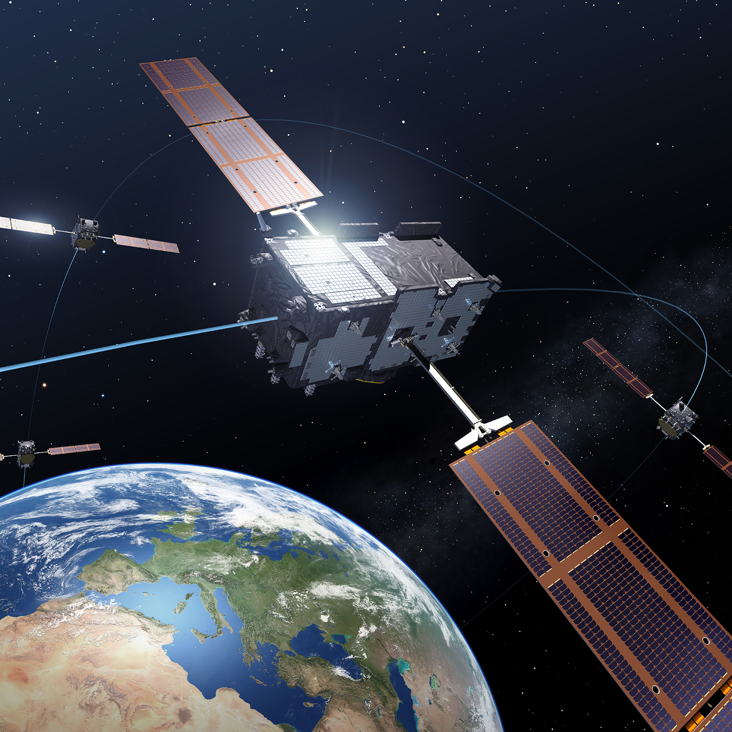
Four Galileo In-Orbit Validation satellites in medium-Earth orbit, the minimum number needed to perform a navigation fix. (Credits: ESA – P. Carril)
According to a report from the Technische Universitaet Muenchen, transmissions of the L1/E1 signal from the recently launched Galileo satellite IOV-3 (FM-3) started at about 13:55:20 GPS Time December 1. Transmissions from IOV-3 of the E5 signal began December 2. By December 4, all three Galileo bands, including E6, were being broadcast, according to the European Space Agency (ESA).
Several stations of the Cooperative Network for GNSS Observation as well as some stations participating in the International GNSS Service’s Multi-GNSS Experiment are tracking IOV-3. The satellite is using PRN code E19.
The Galileo In-orbit Validation (IOV) satellites were launched on October 12 (Flight Model 3 and 4). Now that FM3’s payload has been activated, FM4 is set to begin transmitting test navigation signals later this month. The first two satellites have already passed their in-orbit testing.
Galileo is designed to provide highly accurate timing and navigation services to users around the world, ESA said, so the testing is being carried out in addition to the standard satellite commissioning to confirm that the critical navigation payloads have not been degraded by the violence of launch.
While the satellites are run from Galileo’s Oberpfaffenhofen Control Centre near Munich in Germany and their navigation payloads are overseen from Galileo’s Mission Control Centre in Fucino, Italy, a separate site is used for the in-orbit testing. Located in the heart of Belgium’s Ardennes forest, Redu is specially equipped for Galileo testing, with a 15-m diameter S-band antenna to upload commands and receive telemetry from the satellite, and a 20-m diameter L-band dish to monitor the shape and quality of navigation signals at high resolution.
“This marked the very first time that a Galileo payload was activated directly from ESA’s Redu centre in Belgium,” explained Marco Falcone, overseeing the campaign effort as Galileo’s System Manager. “We have now established an end-to-end setup in Redu that allows us to upload commands generated from Fucino’s Galileo Control Centre to the satellite payload whenever the satellite passes over the station, while at the same time directly receiving the resulting navigation signal through its main L-band antenna.
“The result is our operations are much more effective, shortening the time needed for payload in orbit testing.”
Operating at an altitude of 23,222 km, the Galileo satellites take about 14 hours to orbit Earth, typically coming into view of Redu for between three to nine hours each day.
Raytheon UK has been awarded a significant contract by the UK Ministry of Defence for delivery of a new GPS anti-jam antenna land system. The contract is for an undisclosed number of advanced systems for deployment in operational theaters spanning multiple vehicle platforms. This UOR (Urgent Operational Requirement) contract is the first award for Raytheon’s GPS Anti-Jam (AJ) Land product family.
“Raytheon UK has a track record of on-time delivery for GPS AJ systems, having delivered over 7,000 units for air and naval capabilities in the UK and U.S., said Bob Delorge, chief executive, Raytheon UK. “Many of the military platforms used in operations are protected by the proven Raytheon GPS anti-jam technology, and the first order for our Land GPS AJ product family marks a significant success.”
The contract will see the deployment of the systems under a very short timescale, with final delivery of the capability expected to be completed six months from contract award.
Raytheon UK is a subsidiary of Raytheon Company. It is a prime contractor and major supplier to the UK Ministry of Defence. Raytheon UK also designs, develops and manufactures a range of high-technology electronic systems and software at facilities in Harlow, Glenrothes, Uxbridge, Waddington and Broughton.
Threat Development Parallels Information/Communication Technology
Headshot: Oscar Pozzobon
By Oscar Pozzobon
The GNSS interference session this year at the ION-GNSS conference in Nashville was one of the most crowded, confirming the need of all sectors of the community to understand the threats in GNSS and how they can be mitigated. In that context I received one of the most challenging questions of my career: “Can we predict the future of GNSS security?” What is the status of civil and commercial GNSS security today? Which are the threats and risks and how they are mitigated? Where are we going and what shall we expect from the future?
I decided to tackle this topic carefully, using as a basis and inspiration the history of information and communication technology (ICT) security: from the first threats and attacks of the 1980s to a glance at what technology offers today.
Secondly, to obtain different perspectives — and shift the blame to someone else if one day these predictions should prove to be wrong — I solicited the opinions of three other experts and colleagues in the domain of GNSS and security: Logan Scott, Todd Humphreys, and David Last.
Snapshots from History
The Internet was officially born in 1969 when the U.S. Defense Advanced Research Projects Agency (DARPA) crated the Advanced Research Projects Agency Network (ARPANET). A short 11 years later, the 414 Gang, a computer-hacking organization (the term hacking was coined at the Massachusetts Institute of Technology as early as the 1960s) performed one of the first attacks and frauds upon computer systems. In 1983 the first computer virus was discovered. In 1988 the Computer Emergency Response Team (CERT) was created to report and disseminate information on the threats, and AT&T Bell Labs created the first concept of firewalls. Some readers may recall the 1983 movie War Games, which found Hollywood hard at work on cyber-attacks, denial, and deception to computer systems at a time when we had only six GPS satellites in orbit. One year later, Steven M. Bellovin published a paper on the possibility of performing a transmission control protocol/internet protocol (TCP/IP) Spoofing attack.
Six years after that paper, in 1995, the Computer Incident Advisory Committee (CIAC) reported the first TCP/IP spoofing attack to a system. In another four years, the first denial of service (DoS) attack to computer networks was reported by the CERT. A DoS attack consists of several computer systems sending unsolicited requests to the target, causing a saturation of network and computer resources. In terms of objectives, it could be compared to what jamming causes in GNSS systems.
Between 1984 and 1986, Dorothy Denning and Peter Neumann researched and developed the first model of a real-time intrusion detection system (IDS). This prototype was initially a rule-based expert system trained to detect known malicious activity. I like to think that this could be compared to today’s jamming detection and localization systems.
In the 1990s, the need for guidelines to provide general outlines as well as specific techniques for implementing security became a pressing one for all organizations. The first standard, originally published by the British Standards Institution (BSI) in 1995 was the BS 7799, was later adopted by the International Organization for Standardization (ISO) as the ISO/International Electrotechnical Commission (IEC) 27000 series.
Information technology today can be security-evaluated via the Common Criteria (CC) standard (ISO/IEC 15408), which allows computer-systems certification. CC is a framework in which computer system users can specify their security functional and assurance requirements. The Federal Information Processing Standard (FIPS) 140 is an alternative standard for cryptographic modules, developed by the U.S. Federal Information Processing Standards.
The Nessus Project, started by Renaud Deraison in 1998, set as its objective the provision of an open-source vulnerability-assessment tool. Since 2000, Nessus has become one of most popular tools for computer-network security and vulnerability assessment, used by more than 75,000 organizations worldwide.
ICT security today is assured in a lifecycle composed by CERT managing the threats notifications, ISO/IEC 27000 managing the processes, and CC/FIPS 140 defining the security requirements for the system and vulnerability assessment tools to certify the robustness.
Now, Where Are We in GNSS?
Radio-frequency interferences (RFI) or jamming cases can hardly be tracked, as they are difficult to detect and have a long history in the military domain. Recent incidents such the one at Newark International Airport show that the threat is increasing and demonstrate the need for mitigation strategies. GNSS signal falsification frauds, or spoofing, seems to as yet have no evident cases in the civil domain.
The Volpe Report of September 10, 2001 is one of the first government public announcements of GNSS threats, including jamming and spoofing. More than 10 years, later the unmanned aerial vehicle (UAV) experiment coordinated by Todd Humphreys at the University of Texas proved that such attacks are feasible.
In GNSS, jamming detection (and sometime mitigation) are nowadays commercial options for some professional and mass-market GNSS receivers. Spoofing detection has been available in commercial prototype receivers since 2008 (among others, the Trusted GNSS Receiver (TIGER) funded by the European GNSS Agency. In 2012 we have seen the presentation of the first civil GNSS security testbed. For examples of the latter, see the University of Texas TEXBAT initiative, mentioned on page 37, and the GNSS Authentication and User Protection System Simulator (GAUPSS) project, which involved the development of software and algorithms that were integrated and tested in the radio navigation laboratory of the European Space Agency/ European Space Research and Technology Centre (ESA/ESTEC) in Noordwijk, the Netherlands.
I will make the assertion that compared to ICT security, civil GNSS security seems to be reliving the early days of the 1980s: first publication of attack concepts, first publicly known attacks, no standards, and only prototype mitigation strategies. With a gap of almost 30 years, at least four mid-Earth orbit GNSS systems becoming operational in the next few years, and an annual 10 percent growth rate of GNSS applications, the era of civil GNSS security begins now.
The Question Why
Logan Scott is a consultant specializing in radio-frequency signal processing and waveform design for communications, navigation, radar, and emitter location. His opinion on the future threat leaves no doubts:
“In assessing security threats, an important starting question is ‘Why would someone do that?’ If there is no motivation, chances are, there won’t be an attack. Over the last five years or so, the combination of ubiquitous, low-cost communications systems and satellite navigation has moved civil GNSS positioning and timing into use domains where there are stronger motivations for an attack. Specifically, widespread use in asset monitoring and tracking encourages jamming attacks and so, we are seeing more such attack. As GNSS becomes more deeply embedded into societal infrastructure, we can expect to see more attacks of increasing sophistication. Motivation will be there.”
David Last is a consultant engineer and expert witness specializing in radio-navigation and communications systems. He operates in the domain of covert tracking and law enforcement,, an area where interference can be tempting. As expert in the field, and to the best of his knowledge, he believes that “although there are some cases of jamming, we have seen no events of spoofing — so far. To date, all we have seen from criminals are crude jamming attacks. Attacks by technically sophisticated aggressors who understand GNSS vulnerability have yet to start. They will be much more serious.
“Furthermore, when the receiver stops receiving data in a court case, we can’t say it’s jamming: we can mention that is one of the things that stops the signal. Law enforcement is now beginning to use receivers that can perform jamming detection.”
David Last’s opinion on the issue of potential low-cost spoofers appearing in the near future was also provocative: “Criminals don’t buy things, they steal them.”
The Time is Right, Now
An ICT security standard arrived about 10 years after the first publication and case reports of attacks. Are we at the right time, now, to consider security certification of GNSS receivers?
Logan Scott’s opinion is that receivers should be certified in order to provide awareness of the attacks:
“Today, essentially all houses and buildings have smoke alarms. Smoke alarms don’t put out fires but they do alert the occupants to the probability that there is a problem. Similarly, GNSS receiver situation awareness regarding jamming and spoofing is a first step towards militating against attacks on GNSS components. As civil receivers stand today, many don’t discriminate between loss of lock due to signal attenuation and loss of lock due to jamming. This needs to change.
“Fairly simple algorithms can detect most types of jamming and spoofing. Jammers and simple spoofers almost invariably affect automatic gain control gain settings. They are easy to detect. More sophisticated spoofers have difficulty covering apparent direction of arrival and can be detected using some simple antenna techniques.
“The problem for the user community at large is in knowing whether or not a receiver maintains adequate situational awareness. This is where test-based receiver certification can play a role.”
Awareness is indeed needed to notify to the application the security and authentication state. GNSS authentication integrated in the system still lies far off.
Not only is implementing authentication without compromising user cost and simplicity challenging, but the impact on the ground and space segment in GNSS to maintain legacy signals compatibility is also considerable.
We believe that user-based authentication will be the Plan B for the next 5–10 years. This requires the development of receiver techniques and the use of security testbeds as the baseline for vulnerability assessment, in the same way the Nessus tool was used in the 1990s for computer network assessment.
On the test approach, Logan Scott stresses that “Using a series of canned scenarios, GNSS receivers can be tested to determine how well they maintain situational awareness. Do well enough, and the receiver can be stamped as certified, much like an Underwriters Laboratory (UL) label. The test process can be automated and conducted by an independent third party, similar to the way cellular equipment is certified.
“Additional certifications might include cyber security aspects such as accepting only digitally-signed software updates and maps, providing attestation capabilities, and use of authenticatable GNSS signals.
“The benefit for the non-expert user community is that they have a basis for selecting GNSS receivers, secure in the knowledge that they meet minimum performance standards.”
Testing, Testing
Ringing in my third fellow expert, I asked Todd Humphreys, assistant professor in the Department of Aerospace Engineering at the University of Texas at Austin, for his opinion regarding the future of GNSS security testing.
“A testbed capable of simulating realistic spoofing attacks is needed so that the efficacy of proposed civil GPS signal authentication techniques can be experimentally evaluated. A generic testbed capable of evaluating all known authentication techniques would be prohibitively expensive; for example, it would require a large anechoic chamber for evaluating receiver-autonomous antenna-oriented techniques. But if the scope of evaluation is limited to receiver-autonomous signal-processing-oriented techniques and networked techniques, then it is possible not only to develop an inexpensive testbed but to share the testbed’s data component so that the tests can be replicated in laboratories across the globe.
“In October, we released the Texas Spoofing Test Battery (TEXBAT), a set of six high-fidelity digital recordings of live static and dynamic GPS L1 C/A spoofing tests conducted by the Radionavigation Laboratory of the University of Texas at Austin. National Instruments is hosting TEXBAT on cloud servers so that anyone can download it.
“The battery can be considered the data component of an evolving standard meant to define the notion of spoof resistance for civil GPS receivers. According to this standard, successful detection of or imperviousness to all spoofing attacks in TEXBAT, or a future version thereof, could be considered sufficient to certify a civil GPS receiver as spoof-resistant.
“This is a spoofing-specific version of the ‘not stupid’ certification that Logan Scott has suggested for GNSS receivers. In my July congressional testimony, I advocated requiring a ‘spoof resistance’ certification for GNSS devices that are used in critical infrastructure.”
Looking into the Future
Now I turn and attempt to answer the final question: Can we predict the future of civil GNSS security?
I believe that we can predict that, unfortunately, attacks will increase, and new attacks will be discovered. For example, we have been talking about deception jammers (also known as intelligent, PRN, or gold code jammers) only in the last few years, as an emerging threat. We will see certification and standards for security in GNSS, and we expect them to come in the next five years. Tools for GNSS security testing are already available commercially, for example the Qascom GNSS Security testbed (GST). As ICT has CERT for notification of threat, we will also see the raising of a GNSS emergency response team — possibly called a GERT.
In conclusion, whether my predictions turn out to be correct or not, the good news is that GNSS security also has a history in Hollywood’s annals: the 1997 James Bond movie Tomorrow Never Dies narrates a spoofing attack on the GPS navigation system of a submarine, performed via a GPS encoder that modifies the time.
Again, 007 anticipated the future, and he did it 15 years before a handful of world renowned GNSS security experts.
I have not yet seen the 2012 James Bond film Skyfall. I wonder what it portends?
Oscar Pozzobon is the director and co-founder of Qascom S.r.l., based in Bassano del Grappa, Italy. He received a Masters degree in telecommunication engineering from the University of Queensland, Australia, and is the Italian contact for the Civil Global Positioning System Service Interface Committee (CGSIC).
Affordability, Capability, and Back-to-Basics Acquisition
Headshot: Keoki Jackson
By Keoki Jackson
The history of GNSS shows each year has always been more successful than the year prior, and in 2013 we expect the trend to continue. In the United States, the role of GPS will continue to expand, and the applications for our technology will reach sectors we never imagined. As our international partner countries continue to launch GNSS satellites, and user equipment develops further, our community will increase its globalization, and international cooperation will reach new heights.
At the same time, our industry will see its fair share of challenges. We anticipate several significant trends to be further defined next year.
First, in the satellite world, affordability will be the name of the game. There is no disputing that the U.S. government is in austere budget times, and the Air Force will be asked to do more in acquiring GPS space, ground, and military user equipment, with fewer resources. Industry will partner with the Air Force in this new reality, and on the satellite manufacturing side, industry and government will need to demonstrate reduced costs, while sustaining the constellation and posturing for future demands.
It is no secret that military operations depend on GPS, and adversaries are working aggressively to erode the GPS combat advantage with low-cost jamming devices, spoofing concepts, or cyber attacks. On the user demand side, we expect the need for anti-jamming capability to become even more critical for military users. We also expect users to demand better accuracy and integrity, both in the military and civil communities. In 2013, the United States must secure its critical modernization efforts to meet these demands and bolster the space, ground, and user architecture against potential threats.
For us at Lockheed Martin, the message is clear. The threats and demands for enhanced capability are real, but the budget to meet those demands is shrinking. This presents a challenge, but we believe 2013 is the year we meet the challenge and position for the future.
GPS III, the Air Force’s next generation GPS satellite system, is a central part of the modernized solutions for the challenges laid out above. GPS III is the most affordable way to meet the increasing demand from users, while also prudently posturing the enterprise for the future. In 2013, we intend to prove that.
Space acquisition has weathered painful challenges in the past — that is not news — but the Air Force laid out the GPS III acquisition plan to reverse the trend and regain acquisition confidence. Leveraging hard-won lessons, the Air Force instilled a “back-to-basics” acquisition approach to provide better mission assurance, cost confidence, and schedule predictability. The approach emphasizes early investments in rigorous systems engineering, industry-leading parts standards, and the development of a fully functional GPS III satellite pathfinder to retire risks early and lower overall program costs. These investments early in the GPS III program were designed to prevent the types of engineering issues discovered on other programs late in the flight vehicle manufacturing process or even on orbit.
Back to Basics
The question in 2013 will be, “Is back-to-basics working?” — and we intend to show continued evidence of success next year. We will complete work on the GPS III Non-Flight Satellite Testbed (GNST), our full-sized GPS III satellite prototype. We will ship it to Cape Canaveral Air Force Station, Florida, for pathfinding activities at the launch site as we complete integration of the first space vehicle in our highly efficient GPS Processing Facility. The GNST is used to identify and solve development issues prior to integration and test of the first space vehicle. This will be a major milestone, putting the GNSS community on the cusp of fielding a new generation of PNT capabilities through very efficient and affordable production for all GPS III satellites.
Further proving out the back-to-basics acquisition approach, in 2013 we will be converting our options to build the next eight GPS III satellites to a fixed price contract structure, rather than cost-plus. This transition will limit the government’s risk and significantly contribute to Air Force affordability goals. The back-to-basics acquisition strategy and the progress we have already made on our GPS III prototype give us high confidence in our ability to perform efficient and affordable fixed-price satellite production going forward.
As the austere budget environment is amplified in 2013, we will focus our attention on our GPS III program performance while aggressively pursuing affordability and efficiency initiatives to ensure we are providing great value to the end user while being the best possible stewards of the American public’s investment.
User Demands
Affordability is one challenge; the other is meeting user demands. While the first GPS III satellites will bring on significant new capabilities, including improved accuracy, better anti-jam power, and a new civil signal to be interoperable with international GNSS systems, we do need to continue planning for technology upgrades in the future.
The Air Force laid out the GPS III program from the very beginning with evolution in mind — and the GPS III satellites have pre-architected capacity to add new capabilities and technologies affordably and with low risk. The acquisition plan calls for technology insertion beginning on the ninth satellite. 2013 will be a critical year in finalizing the production schedule for the capability insertion program.
We look at technology insertion in two ways: technology to reduce costs and technology to increase capabilities. To that end, we are developing dual launch, higher anti-jam signal power for the military, a new search and rescue payload, a digital navigation payload with the capability to incorporate new signals after launch, real time command and control cross links to improve system accuracy and a host of other innovations.
The timing for when these new capabilities will be on ramped onto new satellites will be determined by user demands and technical maturity. In 2013, we will be working very closely with the Air Force to implement a low risk ongoing modernization program to ensure GPS III meets the needs of users for decades to come while maintaining or reducing the per unit cost of a GPS III satellite.
In the uncertain and challenging environment of 2013 and beyond, GNSS technology will certainly continue to improve. User demand will increase significantly, while the resources to meet those demands will remain stable or decline. It is a tough challenge, but the GNSS industry has not disappointed yet, and we do not expect anything different in 2013 and beyond.
Dana (Keoki) Jackson is vice president of Navigation Systems in Space Systems Company’s Military Space line of business for Lockheed Martin Corporation. He is responsible for leading all aspects of the next-generation GPS III navigation satellite program for the United States Air Force, as well as operations and sustainment of the GPS IIR and IIRM satellites. Prior to joining Lockheed Martin, he was a NASA research fellow at the Massachusetts Institute of Technology, conducting Space Shuttle flight experiments in the field of human adaptation to the space environment. He has a doctoral degree in Aeronautics and Astronautics fromthe Massachusetts Institute of Technology.
A Proactive Approach for More Efficient Spectrum Use
In my vision of the future of GNSS, I see a pressing need to manage radio-frequency spectrum more efficiently. This will drive the creation of official standards for GNSS receivers, and better design of those receivers with better filters at lower cost, to protect against out-of-band and near-band interference. This in turn will enable user to undertake widespread monitoring and reporting of in-band interference, and create the freedom for many technologies to explore wider and more productive use of all bands of the radio-frequency spectrum.
Spectrum Management
As a consequence of unprecedented technological development on all fronts and in many fields, the radio-frequency spectrum is very congested. All countries, and the United States in particular, must find ways to use this spectrum more efficiently. Licenses for spectrum bands are very expensive, and special interest groups do all they can to secure ownership of any part of the spectrum and to prevent others from competing with them. There is an intense struggle going on, both behind the scenes and in the public arena; it has been called “the spectrum wars.” These involve big companies, very high stakes, politicians, and special interest groups. The Federal Communications Commission (FCC) seems caught, powerless, in the crossfire between these powerhouses.
GNSS Interference
GNSS interference exists everywhere and comes from many different sources, identified and unidentified, intentional or unintentional. The 1-dB effect on GNSS of the proposed LightSquared signal is negligible compared to what already exists. The reason that the LightSquared plan encountered so much opposition was not because of its effect on GNSS. It was because of its effect on the competing business models of large companies and special interest groups.
With the tools that we have created and embedded in our receivers, everyone can easily see that widespread interference already exists in most places, especially in cities, and that interferences can easily be monitored and automatically reported. It seems no organization has ownership of regularly monitoring interferences on these bands and taking corrective actions. This is partly because the tools to easily monitor and report interferences did not exist earlier.
GNSS Receivers
Current GNSS receivers on the market and in use around the world rely on inadequate designs. The technology does in fact exist to overcome out-of-band interference problems such as LightSquared and many others commonly encountered in today’s congested radio-frequency environment. There is no reason to prohibit others from using bands near GNSS; this just makes spectrum use inefficient. Continued shipping of inadequate, inefficient receivers by current manufacturers only increases and compounds the problems encountered by users.
There are standards for manufacturing countless industrial goods — for example, something as ordinary as car tires or — but there is no standard for building GNSS receivers that will be used in critical applications.
So far, the FCC has been silent on this topic, and has not established guidelines for GNSS receivers that are used in critical applications. The civilian users of GNSS, such as the U.S. National Geodetic Survey, the U.S. Geological Survey, the Federal Aviation Administration, and so on, have criteria for all sorts of little equipment, but there is no criteria for GNSS receivers that they claim are so important for their job.
Instead of taking the proactive and productive approach of putting filters into the receivers that they use, these organizations advocate keeping spectrum bands adjacent to GNSS off-limits to other users. Manufacturers do not see any reason to make better receivers while such a powerful lobby protects them.
Interference monitoring and reporting is strongly desirable for places such as GNSS reference stations, or for users to see the interferences before they start a jog that they are tracking on their GPS-enabled personal training device — just as pilots check the weather before they take off.
Special Interest Groups, Politics, and Blind Followers
The problem that LightSquared encountered was that its proposal impacted the business models of special interest groups. Although we — that is, JAVAD GNSS in presentations before the FCC in Washington DC — showed that other interferences exist in cities, the FCC did not care, and GNSS magazine editors did not care. They just blindly followed what the special interest groups had planned for them.
Brad Parkinson, in his article “PNT for the Nation: Three Key Attributes and Nine Druthers” in the October issue of GPS World, did not even hint at guidelines for building GNSS receivers. This is similar to formulating guideline on how to build and clean the roads while having no guidelines on how to build tires that are going to ride on the roads.
In Parkinson’s long list of recommendations, there was no mention at all that we need to build better GNSS receivers and be able to monitor interferences. There are guidelines and standards for how build every little item, but none for GNSS receivers that are claimed to be so essential for our security and prosperity.
Military GPS receivers do not have protection against even one particular type of interference such as that posed by LightSquared — and the suggested approach was to bomb such interferences, which most admit that of course cannot be done. This is a bad attitude. The cost of a filter in a receiver is almost nothing. A precision bomb costs millions if you factor in development costs, and deployment and delivery puts the full cost even higher.
The case is similar for GNSS receivers used in commercial airplanes. Instead of pushing for a better GNSS receiver design, the FAA simply hopes that interference does not happen.
Conclusion
These are my predictions — and my strongest possible recommendations — for the future of GNSS.
The FCC will create standards for GNSS receivers.
GNSS manufacturers will be forced to build better receivers.
GNSS users will benefit from better receivers at a lower cost.
Interference monitoring and reporting will become a desirable feature of GNSS receivers.
Bands near the GNSS spectrum will be freed for more efficient use by all types of productive technology.
I am proud to be a part of the efforts to make these happen, against all odds.
Javad Ashjaee received his Ph.D. in electrical engineering from the University of Iowa. He was chairman of the Computer Engineering Department, Tehran University of Technology, 1976-1981. He began his GPS engineering career at Trimble Navigation, 1981–1986. Founder and president of Ashtech Inc., 1986–1995, the company that produced the first integrated GPS-GLONASS receivers; founder and CEO of Javad Positioning Systems, 1996–2000, which he sold to Topcon Corporation. He founded JAVAD GNSS in 2007, and is currently president and CEO. In 2010, the company introduced the integrated geodetic receiver TRIUMPH-VS, with a GNSS Interference Analyzer, capable of tracking current and next-generation signals of GPS, GLONASS, QZSS, and Galileo signals. In 2011, the company introduced a LightSquared-compatible GNSS receiver.
Our first mistake is to presume an environment of perfection and security. Nothing is foolproof and spoof-free. Every product or service is an envelope of packaging that can be opened, peeled back, reversed engineered, and replicated. I have seen “ultimate security” defeated repeatedly.
GPS is no exception, of course. We put our signatures and seals on these things; enterprising competitors, adversaries, and curious people find a way to steam open our envelopes, create seals indistinguishable from the original, or simply use products in ways unexpected.
We exist in a world headed pell-mell toward the product consumerization, as GPS World tells us, as if this is new. We BYOD [bring your own device, a business policy of employees bringing personally owned mobile devices to their place of work and using those devices to access privileged company resources such as email, file servers, and databases, as well as their personal applications and data. — Ed.] to work with its purchase by credit card and reimbursement by petty cash. This is nothing new than a newer terminology for mass-merchandizing.
Wars will be fought that way too, as if they always weren’t. Soldiers built their own grenades, brought their own weapons, horses, uniforms, and food to the contested game … always. Patton had his own pair of pearl-handled Colt sidearms.
The pressure for encrypted GPS and inconvenient milspec devices misses this reality. Our every weapon will fail unintentionally, get repurposed by knowledgeable adversaries, and be turned intentionally against us. We cannot engineer away these consequences. We can only be better readers. We must be flexible competitors. We have to be open to the reality that everything fails in ways we will not anticipate but should expect.
War is not fought in rows with toy soldiers equal and alike arrayed with fair rules. Fourth generation warfare is here. War is an expediency when diplomacy, economics, and reason fail with adversaries and friends alike. It is fought with a dangerous expediency.
 The device integrates NVS Technologies’ NV08C-CSM multi-constellation (GPS, GLONASS, Galileo, COMPASS and SBAS) L1 receiver with GPRS and Bluetooth communication modules, an RFID reader, and a processor. The Alberding A07 comes with an integrated GNSS antenna, but for monitoring and tracking applications, it is also available with an external antenna.