Blog

  • TerraGo Releases Publisher for ArcGIS v.6

    TerraGo announced the release of Publisher for ArcGIS v.6,  the latest version of TerraGo geospatial collaboration software allows the Esri community to produce TerraGo GeoPDF maps and imagery for users to collaborate without the need for sophisticated GIS tools or training.


    According to the announcement, TerraGo Publisher for ArcGIS provides unprecedented collaboration capabilities by enabling Esri users to extend, exchange and exploit their enterprise geospatial assets by producing highly portable, intelligent and interactive TerraGo GeoPDF maps and imagery. Mobile and field workers can use GeoPDF maps and imagery to easily access, update and share mission-critical geospatial intelligence whether in connected or offline environments.

    Version 6 Publisher for ArcGIS provides advanced GeoPDF map and imagery production and collaboration capabilities that empower users to:

    • Produce GeoPDF applications that are automatically enabled to allow anyone, anywhere using the no-cost v.6 TerraGo Toolbar with Adobe Reader to update and share maps and imagery with georeferenced audio, video, notes, geoforms, and Web services;
    • Support automated GeoPDF map production using Esri data-driven pages;
    • Export feature layers and attributes into TerraGo GeoPDF maps to allow markup and editing in TerraGo Toolbar and Adobe Reader.

    Detailed product information about TerraGo Publisher, Composer and Toolbar v.6 software is available at: http://www.terragotech.com/products/overview

  • TeleCommunication Systems Selects Locaid as Location-as-a-Service Partner

    Locaid, a location-as-a-service company, and TeleCommunication Systems, Inc., (TCS) mobile communication technology company, have announced that TCS’ portfolio of mobile location-based products and services (LBS) will now incorporate Locaid’s location-as-a-service capabilities. This partnership provides wireless operators with access to rapidly deployable location technology for additional financial yield from their location infrastructure, the companies said.

    The TCS-Locaid partnership provides a turn-key LBS solution that includes location network capabilities via TCS’ Xypoint Mobile Positioning Center (MPC) or Xypoint Gateway Mobile Location Center (GMLC) platforms and cross-carrier, multi-source, location aggregation enablement. Through this partnership, Locaid’s aggregation solution integrates with TCS’ network location platforms and enables wireless operators to rapidly enhance their monetization of a location technology investment. Further, TCS facilities enable hybrids of in-network, hosted or managed services location platforms and cloud-based location aggregation enablement, the companies said.

    Locaid President and CEO Rip Gerber said, “TCS is known for providing carriers with new revenue opportunities and delivering them in a rapidly deployable, hosted and turn-key way. This agreement is testimony to the importance of Location-as-a-Service among the biggest players in mobile, and it is an historic first step between our two companies.”

    “With the appropriate privacy protections, the location of an individual has proven to be a valuable asset that can enhance the value of a carrier or enterprise’s service,” said Lynne Seitz, vice president of location products, TCS. “One of our key goals is to help our carrier customers to monetize this asset by making it available on demand to third parties across a wide-variety of verticals. After an extensive study of the mobile location market and providers, we selected Locaid for their commitment to privacy and impressive portfolio of content providers, enterprises, application developers and merchants who will compensate operators for access to location.”

  • Soyuz Takes Shape in French Guiana for Dual Galileo Launch

    Assembly process for the Soyuz launcher began with integration of the four first-stage strap-on boosters to the Block A core second stage (photos at left and center).  At right, the Block I third stage is seen after its mating to the launcher’s core.

    The launcher for Arianespace’s next Soyuz mission from the Spaceport in French Guiana is completing its initial checkout for a flight in the second half of 2012, which will carry another two spacecraft for Europe’s Galileo satellite navigation constellation, according to Arianespace.

    During activity at the Spaceport’s Soyuz Launcher Integration Building — known by its Russian “MIK” designation — the vehicle’s four first-stage strap-on boosters have been mated with the Block A core second stage, followed by integration of the Block I third stage.

    With its initial build-up concluded, the Soyuz is undergoing regular maintenance checks that are standard for the Russian-built vehicles that have been in storage prior to their mission. Such verifications include testing of the launcher’s pneumatic and electrical systems, Arianespace said.

    This Soyuz will carry Europe’s next two Galileo In-Orbit Validation (IOV) satellites, joining the first pair of spacecraft lofted on Arianespace’s historic maiden flight of the Russian-built launcher from French Guiana in October 2011. Once the four IOV satellites are in orbit, they will provide the minimum information needed for space-based navigation: latitude, longitude and altitude data, along with ranging accuracy, enabling assessment of the Galileo system’s performance, while also allowing suppliers to realistically check their receivers and services against actual signals.

    Arianespace has been chosen to deploy the entire Galileo constellation of 30 satellites. This began with the launch of the first two experimental satellites, GIOVE-A and GIOVE-B, orbited by Arianespace’s Starsem affiliate on Soyuz launchers from Baikonur Cosmodrome in 2005 and 2007. Subsequently, Arianespace lofted the initial pair of In-Orbit Validation spacecraft on Soyuz’ October 2011 inaugural mission from the Spaceport.

    The remaining 24 Galileo constellation satellites will be orbited through 2015, using six additional Soyuz vehicles carrying two spacecraft each, along with three Ariane 5s configured with four per launch.

    Initial phases of the Galileo program were carried out by the European Space Agency (ESA) in activity co-funded with the European Commission. Galileo’s Full Operational Capability phase is being managed and funded by the European Commission, with ESA and the Commission having signed a delegation agreement by which the space agency acts as design and procurement agent.

    The upcoming Galileo mission is designated VS03 in the numbering system for Arianespace’s launcher family — which is composed of the medium-lift Soyuz, heavy-lift Ariane 5 and light-lift Vega – all operated at the Spaceport. The “V” represents the French word for “flight” (Vol), while “S” signifies the use of a Soyuz launch vehicle. Its “3” denotes the third Arianespace mission of Soyuz from French Guiana.

  • Thoughts on Mobile Devices, UAVs, and Cheap Data-Collection Software

    On the coattails of last week’s Geospatial Solutions newsletter outlining the United Nations’ five- to ten-year vision on geospatial information management, and my column on the mobile device operating system war, here are some more thoughts on those subjects.

    As the cost of GIS data collection devices (handheld, tablet) has plummeted in the past two years and smartphones have proliferated, the quest for inexpensive GIS data-collection software has intensified. It makes sense. When people were used to paying thousands of dollars for a GIS data-collection device, another US$800-$1,000 for GIS data collection software seemed reasonable. It might have added 15-25% to the total price of the system. With today’s inexpensive devices, sometimes data collection software ends up costing more than the device itself, thus pushing the demand for cheaper software. On top of that, as I discussed a couple of weeks ago, we are in the middle of a mobile device operating system war. Whereas it used to be a no-brainer that Windows Mobile (or some derivative of it) was going to be the dominant operating system and supported by software developers, that’s not the case any longer. Windows Embedded is going to be around, but it’s clearly not the dominant mobile device operating system it once was.

    Interestingly enough, GIS data collection software for iOS and Andoird have followed the iOS and Android price trends. The mobile devices running iOS and Android are inexpensive, sometimes free. You don’t see any iOS or Android GIS data collection software packages costing thousands of dollars. On the other hand, many Windows Mobile-based geospatial softwares cost upwards of US$2,000. Of course, you can make the argument that the Windows Mobile-based softwares are mature and feature rich. That’s true, as most of the iOS and Android-based softwares have a fraction of the capability, but I’d venture to say that most users don’t need many of the features they are paying for. I also agree with one of the trends outlined in the UN document in that I think open source might be where things are headed.

    • Free and open source software will continue to grow as viable alternatives both in terms of software, and potentially in analysis and processing.

    Ironically, open source GIS data collection software has been around for years. However, you probably don’t know about it because no organization is actively marketing it (if there’s no revenue, there’s no marketing budget). Software like gvSIG Mobile is a reasonably powerful GIS data collection product. A little quirky? Perhaps. But, if your budget is depleted and your requirements exceed the capabilities of the typical free or inexpensive software in the iTunes or Google Market, you might tolerate the quirkiness.

    gvSIG Mobile Open Source GIS Data Collection Software.
    gvSIG Mobile Open Source GIS Data Collection Software.

    The UN also predicts that geospatial data will trend toward open source.

    • Within five years the level of detail on transport systems within OpenStreetMap will exceed virtually all other data sources and will be respected and used by major organizations and governments across the globe.
    • Community-based mapping will continue to grow.
    • There is unlikely to be a market for datasets like those currently sold to power navigation and location-based services solutions in five years, as they will have been superseded by crowdsourced datasets from OpenStreetMaps or other comparable initiatives.|
    While I agree that the trend towards open source data is gaining traction, five years is a really aggressive timeline for phasing out the likes of TeleAtlas (owned by TomTom) and Navteq (owned by Nokia). These are the two major map database suppliers for virtually all GPS navigation devices used in vehicles around the world. I think there will be, for the forseeable future, a quanitifiable and valued difference between open source data and commercial geospatial data. Commercial users will pay for perceived quality and accountability, especially if the price differential is minimal. Consumer GPS users (vehicle navigation) might be a different story. A $30 difference in retail price can sway a consumer from one brand to another.
    More on UAVs for Mapping
    One of the first trends in the UN listed are:
    • There will be an increased demand for applications to be used with high-resolution imagery.
    • The use of Unmanned Aerial Vehicles (UAVs) as a tool for rapid geospatial data collection will increase.

    Trimble’s acquisition of Gatewing just last month supports this trend as well as the Obama administration’s accelerating the use of civilian UAVs back in February of this year via the National Defense Authorization Act of 2012.

    Cost-effective mapping UAVs are starting to emerge. In just this past week, Event 38 announced a small mapping UAV for under US$1,000.

    Low-cost E382 Mapping UAV from Event 38.
    Low-cost E382 Mapping UAV from Event 38.
    Augmented Reality

    As does the UN vision, I think augmented reality has a bright future for both commercial users and consumers.

    • Augmented reality applications will be pervasive, with the ability to view a whole range of data overlays on top of the real world.

    For professional geospatial users, the situational awareness possibilities are tremendous. Imagine the backhoe operator being able to “see” the underground infrastructure in order to avoid it. Imagine the park superintendent being able to “see” all of the underground irrigation and drainage lines by simply positioning a tablet computer towards the area of interest.


    Thanks, and see you next week.

    Follow me on Twitter at http://twitter.com/GPSGIS_Eric

  • CAST Navigation: Signal Diversity and the PHGPST

    As loyal readers are aware, I have long been an advocate of signal diversity as a solution to many of the ills that plague the GPS user, especially outdated user equipment. Signal diversity potentially provides users with more signals and signal origins. More signals improve availability, the number-one user criteria by a huge margin, and serve as a defense against jamming and spoofing. Signal diversity also provides security and integrity, resulting in accurate and reliable GPS-derived data.

    For users to take full advantage of signal diversity, they must have the best software-defined user equipment available. And the best equipment, if it were available today, would be the PHGPST or Perfect Handheld GPS Transceiver, which has so often been a popular topic of discussion over the last several years. I cannot count the thousands of letters and emails from warfighters, first responders, and civil users who immediately see the value of software-defined receivers and want to know where to purchase the PHGPST. For now, some early GPS software-defined user equipment does exist, but to reach the goal of the PHGPST, receiver manufacturers must first be able to accurately and reliably simulate/generate all the diverse PNT (position, navigation and timing) signals available, which include some signals not ordinarily categorized as PNT signals today. Certainly not an easy task; however, there is hope. Recently, I heard about a small GNSS/INS simulation company that may be paving the way to the PHGPST — CAST Navigation in Tewksbury, Massachusetts.

    CAST Navigation

    CAST Navigation, which qualifies under current federal acquisition guidelines as a small company, bills itself as, and my military contacts confirm that they are indeed, a leading provider of GPS signal simulators, as well as a company that supports navigation system research, development, integration and testing at commercial and military laboratories worldwide. CAST develops cutting-edge GNSS/INS simulation systems with an expert staff that provides their customers with the latest technology and knowledgeable, experience-driven support.

    Tough Industry

    Those of you who are real GPS techies should not have to think very hard to call up the names of at least three GPS–PNT signal simulation companies that have gone belly-up in the past five to ten years, and some of those memories are just plain painful for the U.S. military and industry alike. This can really be a tough business.

    According to Susan Gove, vice president of CAST Navigation, “…the signal simulation field is certainly not an easy business and it is extremely competitive, but we have been around for a long time and are doing well,” which is exactly why a company like CAST Navigation — which has survived and grown for the last 25+ years with an outstanding track record — is of such interest when it comes to PNT signal diversity and the PHGPST.

    Add the fact that recent Information Assurance (IA) and cyber security requirements have just made the GNSS business tougher for all concerned and a reliable, professional, flexible GNSS/INS signal simulation company becomes critically important to the industry as a whole. According to John Clark, VP for Engineering at CAST Navigation, “…our scenario-based software simulations, which include jamming, interference, multipath signals and spoofing allow for simultaneous and multiple scenarios — indeed, almost any battlefield signal perturbation the user needs to simulate is doable with our hardware and software. In fact, we routinely help our customers tailor scenarios for specific needs, and our customer feedback mechanism tells us our customers are extremely happy and productive with CAST Navigation’s scenario-driven software capabilities.”

    cast_1000-W . Credit: Cast
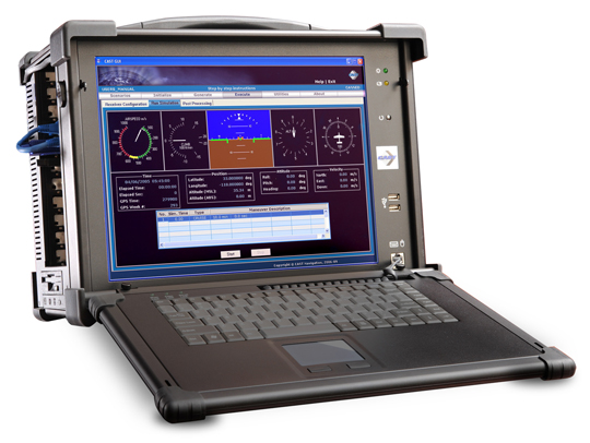
    The CAST-1000 GPS Simulation System.

    Signal Diversity

    A major requirement for signal diverse solutions to GNSS issues — to include jamming, unintentional interference and high masking angles — is the right antenna. Conventional wisdom says the right antenna is a Controlled Radiation Pattern Antenna or CRPA. Ideally, the right CRPA will eventually be capable of receiving all space-based PNT and SBAS signals (GPS, GLONASS, Galileo, Beidou, WAAS, EGNOS etc.) as well as ground-based cellular and LF (low frequency) and/or eLORAN signals. The CAST-5000 Wavefront simulator allows companies and the military to perform a full end-to-end test of a platform’s CRPA, the antenna electronics, and the GPS receiver before that receiver is ever deployed to the field. So it is a must-have capability for the truly signal diverse GPS receiver manufacturer. But to be honest, GPS signals are still key; they are still the gold standard for PNT. I am not aware of any GLONASS-only receivers on the market today, nor am I aware of any Galileo-only receivers being planned. GPS is the key component for available, reliable, and accurate PNT data.

    Recently at the Munich Satellite Summit, all the European receiver manufacturers were touting GPS receivers with the Galileo/GLONASS option. Even if the marketing brochures list Galileo or GLONASS first in the name, a little probing makes it obvious that the primary baseline PNT system is GPS with augmentations. So although signal diversity is the goal and more and more systems are, to some extent, signal diverse or signal-diverse capable today, the reality is that GPS is still the Gold Standard. If we are ever to truly enjoy signal diversity and all the associated benefits, PNT signal generators and simulators will be a key developmental tool. To that end and with affordability in mind, CAST Navigation has the capability or is in the process of developing simulations for many of the diverse signals mentioned to include SAASM signals for the U.S. military and our allies.

    Simulations and Predictions

    For the past several years the DoD and several government agencies have made good use of a very functional PDOP (positional dilution of precision) prediction algorithm and tool named GIANT. General Dynamics originally developed the GIANT program under contract to the U.S. government. Currently, GIANT is being enhanced primarily by LINDQUIST, with the help of select government agencies; with the recent integration of Google Maps, GIANT is proving to be a very useful tool for the warfighter and first responder. Amazingly CAST Navigation has a very similar product that is available for all users to include the U.S. military. The CAST product is called TOP or Terrain Obscuration Program. Like GIANT it provides a real-time determination of satellite visibility based upon the terrain (presented in a 3-D visualization) surrounding the actual position or predicted position of specific GPS receivers, fixed or mobile.
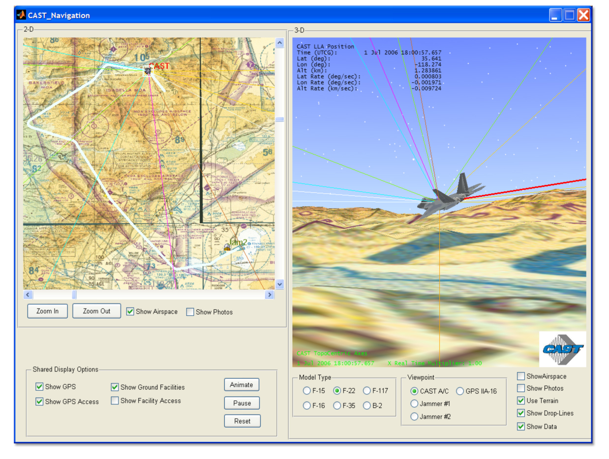
    TOP170map . Credit: Cast
    (Click to enlarge.)

    While this concept sounds a bit academic at first, when you see it in action and talk to warfighters and planners who have benefited from GIANT first hand, it is clearly a mission-success parameter as well as a life-saving capability. For years GIANT was purely a flat Earth planning tool, and while it was useful, the addition of real-time processing, Google Maps, and DTED data have made both GIANT and TOP incredibly useful programs. Both programs help ensure GPS user equipment, applications, and weapon systems are more accurate, since signal availability is now predictable. The first time I saw the new GIANT tool in action, it literally took my breath away, and now that capability is available for everyone with the TOP product from CAST Navigation. Knowing first-hand what both GIANT and TOP are capable of for warfighters and first responders, I cannot now imagine a government, commercial, or civil planner, who must utilize or install GPS equipment or systems that depend on GPS capabilities, that would not benefit from these groundbreaking programs. In a natural or urban canyon situation, with high masking angles, installing GPS receivers or antennas with the greatest visibility would be pure guesswork without a program like TOP that guides planners and installation engineers with real-time data extrapolating optimal PNT reception locations, both fixed and mobile, over time.

    sgx_high-W . Credit: Cast

    SGX

    Combine the capability of GIANT or TOP with a portable or handheld GPS signal generator/simulator, such as the new handheld CAST SGX, and users are able to accurately characterize and predict the effects of area terrain and masking angles on any GPS receiver prior to actually venturing into the field. Users are able to determine which receivers will function optimally and produce the most reliable results in any physically constrained or sky-challenged environment. For both government and civil users, the fidelity of TOP and GIANT are a direct function of and only constrained by the Digital Terrain Element Data (DTED) access authorized for specific users.

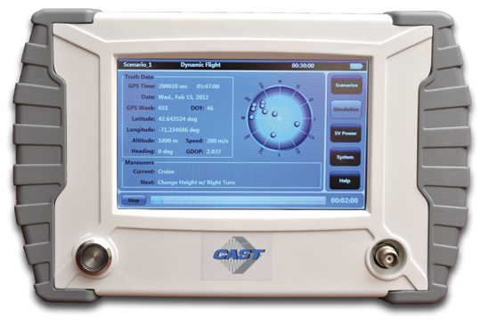
    The CAST SGX (signal simulator/generator) is a GPS signal device housed in a portable lightweight handheld enclosure. In other words, it is a portable handheld GPS signal device at home in the laboratory, running on house current, or in the field running on long-life batteries. Regardless of the power source, the CAST SGX is capable of generating GPS L1 signals (with P-Code options) of up to 16 GPS satellites, which are more than most users would normally have in view at any one time.

    The CAST SGX is an important new development in GPS signal simulation and generation. Historically GPS signal simulators/generators have been huge, heavy and complicated pieces of laboratory equipment requiring a Ph.D. to run properly, and users were tied down to evaluating GPS receivers only where the unwieldy GPS signal simulator/generator was located. Now with the portable CAST SGX, the signal generator can go where the receivers are located and real-world data can be collected in real time. The scenarios the SBAS (satellite based augmentation system) capable SGX have made available are extraordinary, and I have purposefully not speculated on the military possibilities as those speculations become classified in a hurry. But just allow your imagination to wander a bit and you will see what I mean.

    SGX Software

    The optional CAST-XGen Plus software, which I have not had a chance to personally test but hope to in the near future, has the capability to integrate with Google Maps and reportedly gives the user the ability to generate advanced customized scenarios for use with the SGX device. The software allows for complete control over atmospheric effects, the GPS almanac, ephemeris and all satellite error sources to include masking angles and multipath. So you don’t actually have to take the SGX device out into the field, but the great part is now you can. Ruminate on that for awhile and the possibilities appear endless.

    According to Susan Gove, the handheld SGX is proving to be a huge success, and the SGX along with CAST Navigation software products will be available at the ION 2012 Joint Navigation Conference
 (ION JNC) June 12-15, at the Crowne Plaza Hotel in Colorado Springs, Colorado. Be sure to stop by and take a look at this amazing new product.

    Bottom Line

    I am impressed by what I have learned about CAST Navigation. They are a small, agile, innovative GNSS/INS simulation company that has brought much needed portability and availability of GPS signals and simulation to operators, planners, and system designers worldwide. CAST Navigation hopefully has a bright future and may well play a key role in the future of the availability and integrity of GPS signals for users globally. They may also help blaze the path to the PHGPST. Check them out at ION JNC.

    Until next time, happy navigating.


  • Indoor Positioning: Overhyped or Just What LBS Needs?

    Because LBS Insider’s deadline is this week, CTIA coverage from New Orleans is not included in this month’s column.  Janice Partyka, editor of GPS World’s Wireless Pulse, is covering CTIA in the Crescent City for the latest location-based services, M2M, and connected vehicle news.  So instead of talking about CTIA (and why there aren’t many pure LBS players or sessions there anymore), this column examines the hype surrounding indoor positioning — is it LBS’ savior, or just another technology that may, or may not, pan out?


    The location industry will know very soon whether indoor positioning is just another overhyped technology niche — or the needed capability that will drive the largest advertisers and retailers to finally embrace location-based services. Some industry analysts say indoor location may take off in as few as 12 months — particularly if smartphones include the feature in new product offerings.

    At several location industry conferences, the obligatory indoor positioning panel is cropping up, leading some to believe that while intentions are good, perhaps the technology hasn’t developed fast enough. The jury is still out on indoor positioning. “It is badly needed, but also needs to be down to the meter-level,” said Ralph Eschenbach of Sand Hill Angels, a venture capital firm, at the recent GPS-Wireless 2012 conference. “The technology is not here yet.”

    Another contrarian said that industry segments like automakers need not just show users how to navigate to destination, but give folks information when they near the area. “It would be nice if a BMW told me where’s the cheapest gas,” said Gary Gale, Nokia director of places, location and commerce.

    Some analysts, like those at IMS Research, believe that an indoor positioning technology will be from multiple sources — though Wi-Fi has been the primary tech solution. IMS cites reports that say Bluetooth in Nokia’s HAIP can meet the one-meter threshold of accuracy for indoor markets.

    IMS said the major indoor positioning players, so far, are Google, Qualcomm, Broadcomm, CSR, Qubulus, Nokia, NextNav, and Path Intelligence.

    While intangible benefits such as measuring consumer behavior and shopping experience will be important for retailers and advertisers who are hoping to fund indoor positioning systems, the goal is to drive customers to the stores. This will also be tied into the “what do I do when I get there” answer to the navigation question.

    Still, the benefits will be transparent to advertisers once consumers are able to save time, and perhaps money, with indoor positioning capability on their smartphones, said Ankit Agarwal, CEO of indoor positioning company, Micello. “There is definitely a business model for indoor positioning. It enables product search and walking paths throughout a store,” he said. “Stores will be able to track multiple routes folks are interested in taking [through a store].”

    Once again, Google seems to be the major player in indoor positioning. LBS Insider reported late last year that Google went indoors with the launch of Google Maps 6.0. The company has attracted some of the big-box retail stores such as IKEA, Macy’s, Home Depot, and Bloomingdales to have their stores mapped. However, a lot of the bigger malls, and Target and Wal-Mart, have not been mapped. The Google product tells customers what floor they are on in a building, but so far is only available for Android.

    Google’s indoor mapping partners include 18 U.S. airports, which will open up more partners and LBS relationships in the future.

    In other news, but related to indoor positioning and other LBS markets, Greg Tarr, partner at Rogers Venture Partners, said at GPS-Wireless: “There is no privacy…get over it.”

    TomTom Launches Global Geocoding Web Service

    As GPS World reported, TomTom launched a new volume batch geocoding web service late last month at the Geospatial World Forum in Amsterdam. Geocoding, the process of converting addresses into geographic coordinates to allow location analysis for businesses, is taking on a new twist with the new product.

    “This not your father’s geocoding. The turn-around time to download the product will be attractive to companies,” said Dan Adams, TomTom vice president, location and live services. “When I was with GDT and we were acquired by Tele Atlas, it gave us more exposure to global geocoding. Since the TomTom acquisition, there has been a recasting of those products, with the same sort of dynamics, but bringing them to the Cloud.”

    What Investors Look for in a Location Company

    In a venture capital panel at GPS-Wireless, industry experts basically say that location markets mean more than just navigation now. They also have some strong opinions on the composition and strategies of companies they plan to invest in.

    “We notice that some startups don’t have enough engineers,” said Sanjay Subhedar, Storm Ventures managing director.

    Other VCs say they look first at the market size of the location niche, but still believe the personality of the company’s management team is important. However, there was no location market segment any VC agreed on; some were sold on the promise of enterprise markets; others believe a strictly consumer play is where the future is.

    LBS Insider Covering ITS America Conference

    Not a sexy show like CTIA or Telematics Detroit (which is being boosted by the connected car craze, despite its jaw-dropping price to attend), ITS America’s annual meeting this month in the Washington, D.C., area will feature connected vehicle sessions and government programs. Before market-centric conferences as Telematics Detroit and Where 2.0, ITS America, even with its government focus, was the only game in town for companies looking to get into the navigation and location business.

    One of these “government programs” traditionally featured at ITS America is distracted driving sessions, which at least one analyst says younger drivers don’t want to be bothered with. “Only 20 percent of young consumers are worried about distracted driving [we found in our studies],” said Thilo Koslowski, Garnter vice president, who also said, unlike what some automakers and analysts believe, that a car is not a “laptop with four wheels.”

    LBS Insider will be covering the ITS America annual meeting. If attending, contact us with your story ideas.


  • Hemisphere GPS Provides New Snow Grooming Guidance and Snow Depth System

    Photo: Hemisphere GPSHemisphere GPS has announced the EquiPiste integrated snow grooming management system. EquiPiste provides visual guidance, snow depth status, and event logging for snow grooming operators, mountain managers and snow road operations. Ski resorts benefit from improved grooming quality and productivity, optimal snow making decisions and distribution, as well as more predictable and preventative snow cat maintenance, according to Hemisphere GPS.

    Snow grooming operations are tasked with creating quality snow conditions for ski trails or pistes, as they are referred to in the industry. Designed with an integrated touchscreen terminal and Crescent GPS, Hemisphere GPS’ EquiPiste graphically displays to the operator the areas groomed, boundaries, assets, points of interest, and hazards. Through the guidance cues, operators increase their efficiency and quality of work by avoiding overlaps and skips in grooming, Hemisphere GPS said. Areas that need attention such as thin snow pack and winch anchors can be flagged with meta-data so operators can easily navigate back at any time, even in low visibility. Pathways can be mapped and re-used for training novice operators or for repeatedly navigating snow roads. Operation managers benefit from reviewing the job files from each machine to determine variable costs, performance and maintenance tracking, the company said. As well, data can be mapped within Google Earth and used for generating daily grooming or road maintenance reports for customers.

    Many ski resorts also spend a substantial amount of their budget on snow making activities. When combined with Hemisphere GPS’ survey grade Eclipse GNSS technology, EquiPiste displays and records real-time snow depth measurements and maps, the company said. The snow depth data improves the efficiency and quality of managing the snow levels. The depth data helps indicate where and when to make snow, it alerts the operator to thin snow pack, where to redistribute snow as well as how to identically recreate (day to day and year to year) downhill race courses. Analysis of the snow depth data enables more optimized snow management.

    “Through collaboration with the ski resort and snow vehicle machine industry we have customized existing Hemisphere GPS technology to serve an adjacent vertical market,” said Andre Roberge, senior manager of New Ventures at Hemisphere GPS. “EquiPiste is truly a comprehensive snow management system that allows ski and snow road operations to capture and visualize the status and behaviour of snow for optimized grooming and manufacturing. Our customers have experienced tremendous benefits in productivity, quality, and safety as well as significantly reduced operational expenditures and lowered environmental impact. As a result, EquiPiste customers are able to provide a better standard of service and experience to their customers.”

  • Safe Software and Blue Marble Geographics Partner for Innovative Data Transformation

    Safe Software and Blue Marble Geographics announced that they have teamed up to bring the best of both of their products together in one authoring environment to increase the possibilities of what can be achieved in the use and distribution of spatial data. With the release of the GeoCalc Extension for FME, in addition to FME’s industry-leading format support and flexible transformation capabilities, users can have access to Blue Marble’s highly accurate coordinate transformations directly through FME Workbench.


    According to the announcement, the GeoCalc Extension for FME allows those relying on GeoCalc’s coordinate transformations to bring them into FME’s intuitive graphical user interface where they have access to FME’s unparalleled format support and data transformation capabilities.

    “GeoCalc and FME are highly complementary products,” says Patrick Cunningham, President of Blue Marble Geographics. “By integrating the two, our users can take advantage of FME’s excellent data transformation authoring environment, while directly accessing the highly accurate coordinate transformations they rely on in GeoCalc.”

    For FME users, access to the Blue Marble coordinate engine means more choice in coordinate transformations, and increased vertical height conversion accuracy and flexibility.

    “We are very excited about how this integration will increase the possibilities of what users can achieve with FME,” says Dale Lutz, Vice President of Development at Safe Software. “For example, we are seeing an explosion in the use of 3D data, particularly LiDAR, and GeoCalc’s superior geoid selection means more accurate reprojection results.”

    With the GeoCalc Extension, FME users with a valid Blue Marble Desktop GeoCalc license can select the GeoCalc datasource for use in coordinate transformations directly from FME Workbench. Through the Blue Marble Desktop administrative tools, they can also guide end users to preferred coordinate systems and transformations by specifying which GeoCalc systems and geodetic objects are available for import into FME.

    According to the announcement, the integration also provides access to fine datum shift control, including the option of processing shifts with late binding transformations or direct datum transformations, avoiding the potential loss introduced by using an interim WGS84 datum shift.

    The GeoCalc Extension for FME is currently in beta and will soon be available from Blue Marble Geographics.

  • Event 38 Announces UAV For Mapping

    Event 38 announced its first major product, model E382, a ready-to-fly mapping UAV. Based on the Ardupilot Mega 2.0 autopilot, the E382 is designed to take aerial photos quickly and easily.


    According to the announcement, equipped with a small point and shoot camera, the E382 can make five centimeter resolution maps from individual pictures stitched together. Digital elevation models and georeferenced orthorectified maps can be made using online services like DroneMapper.com.

    Event 38 reports that the E382 is capable of flying for just under an hour and can cover over 200 acres at a time on one charge. For larger areas, replacing the battery is quick and can be done in the field. Weighing in at under five pounds and made of soft, durable foam, the airframe is resistant to damage and can’t significantly damage anything on the ground. The 66″ wings come apart for easy transport to and from the job site.

    The basic kit consists of a ready to fly airframe with autopilot, motor and servos installed. Options are available to add on for those without any R/C gear like a controller, batteries and a suitable point and shoot camera. If you’re starting without any gear, a full system costs about $1,050. Training and on-site setup are available as well.

  • DigitalGlobe, Inc. Rejects GeoEye’s Proposed Acquisition

    GeoEye announced that DigitalGlobe, Inc.’s Board of Directors has rejected GeoEye’s acquisition proposal. On May 4, 2012, GeoEye announced a proposal to acquire DigitalGlobe for $17.00 per share in total consideration, payable $8.50 per share in cash and $8.50 in GeoEye stock, or 0.3537 shares of GeoEye stock for each share of DigitalGlobe stock, representing a premium of 26% to DigitalGlobe’s closing price as of May 3, 2012.

    “We are disappointed that DigitalGlobe’s Board of Directors has rejected our highly attractive proposed acquisition,” said Matt O’Connell, CEO of GeoEye. O’Connell continued, “We believe, and DigitalGlobe appears to agree, that combining these two companies makes clear strategic sense. A combined company would generate substantial synergies while better satisfying the needs of all customers, domestic and international. The combined company would be able to deliver significantly greater certainty in the continuity and quality of its future satellite constellation. We view this proposal as being proactive to continue to deliver the high level of service to our government and commercial clients in the most cost effective manner.”

    GeoEye reported it will consider its options in light of DigitalGlobe’s rejection. We have engaged Goldman, Sachs & Company, Convergence Advisors LLC and Latham & Watkins LLP to advise us in this transaction.

  • The Evolution of Spirent GNSS Simulation

    Spirent’s simulation systems have changed significantly from their technology beginnings, which can be traced back to World War II radars. The company and its technology have evolved to keep pace with today’s growing population of GNSS constellations and to meet the challenges that receiver manufacturers and users encounter in an ever-complex integrated GNSS environment.

    In the early days of GPS when there were only enough satellites for a fix at odd times of the day or night, these nighttime expeditions were the only form of testing that we could get our hands on. Then as the constellation grew, we were delighted when eventually you could do open sky testing whenever you needed. It never even occurred to us that more exhaustive, more complex testing would become essential as time progressed.

    If you walked into any GNSS manufacturer’s testing facility nowadays, the ubiquitous test rack at the heart of most test validation systems might well include a Spirent simulator of some vintage. I recall when we were bringing up receivers in engineering, one of our concerns was how the heck could we afford another one of these beasts for the guys down in production? After we already broke the bank when we managed to convince management that we couldn’t live without a Spirent, we were wondering who we’d push to the front of the line to tell the boss that we had to buy yet another one for the guys on the production line. At one time before a cut-down single channel box became available, we shared our simulator with production who operated the system remotely and a coax run provided RF onto the production floor. We still did open sky testing in R&D, but the complex validation scenarios would have been impossible for the team without our Spirent simulation system.

    Recently I got to wondering where Spirent had come from and how come they had become one of the leading players in GNSS simulation. I did recall that they were UK based, that there were a number of name changes and that at one stage they also had receiver capability. So I got talking with John Pottle who’s always been my marketing window into Spirent, and Peter Boulton who’s been my principle technical contact. I was interested in Spirent’s background, their engineering capability, how they got where they are now and where they plan to go in the future.

    Its not surprising that Spirent’s roots go way back in England to the period of the second world war. England developed radar as an early warning system that helped win the air combat Battle of Britain. Following the extensive blitz bombing of London, the UK government subsequently re-located the radar technology team well out of harm’s way to the distant and more secure southern tip of England, and that technology team formed the core of a high-tech group based in Paignton, Devon which eventually evolved to focus on GNSS simulation.

    Southern England – Paignton base for Spirent.

    It’s a nice area to live in, with fewer people, smaller towns and a very pleasant climate. So the technology guys and their families hung around and the government facility became Standard Telephones (STC) and Cables Defence Systems. Focusing in those days on travelling wave guides, cathode ray tubes, and radar amplifiers and the like, this business grew to include solid-state amplifiers, satellite communications and repeaters for fiber-optic networks. This all needed test equipment and a test division grew up to service STC’s technology groups.

    As GPS came on line, the UK Government Royal Aircraft Establishment (RAE) needed GPS simulation capability to verify GPS system performance, and STC came up with a test system equipped with 6 dual-frequency satellite signal sources with additional jamming sources and a range of military data interfaces.  The computer operating system was VMS running on a Digital Microvax2 platform, the software was written in DEC Fortran and the DOS-like user interface had textual menus with a graphics terminal for X-Y plots. Just like we had racks of equipment for the original single channel GPS receivers, GPS simulation systems started in the same way.

    RAE GPS Simulation System 1987.

    In parallel STC was also working on a contract to develop a military GPS receiver, and several of the GPS ASICS used in that receiver found their way into the simulator. Simultaneously, the RAE contract was extended to include provision of full SA-A/S capability, which was delivered in 1988. This classified system was used to formally evaluate the Rockwell-Collins 3A receiver SA-A/S implementation – at the time this test system was the only one available capable of emulating all the features of SA-A/S.

    As it became clear in1988 that GPS would have a wider commercial market, STC began to invest in simulation systems for commercial receiver manufacturers.

    STR2740 Simulator 1989. STR2760 Simulator 1991.

    With dual frequency and up to 10 satellite channels, the STR2740 was still quite large as it was based on the floor standing Microvax2. Porting the software to a desktop VMS workstation gave us the more familiar STR2760 that was first displayed at the ION-GPS-1991 convention in Albuquerque. This initial unit was actually purchased from the ION display show floor and STC had to hustle to quickly make more!

    Then ownership passed to Northern Telecom in Canada, who was initially interested in STC’s fibre-optic communications technology and products. After a few years, Northern Telecom changed its name to Nortel – so then we all started talking about ‘Nortel simulators’. The next phase of internal development re-tuned the technology and the resulting 1997 STR4760 simulator boasted double the channel capacity and enabled the inclusion of GLONASS and SBAS capability.

    Spirent-1997
    STR4760 Simulator 1997.

    In the same timeframe, development of a Controlled Radiation Pattern Antenna (CRPA) was underway in Paignton, but this didn’t quite fit with a business focus on testing, so the CRPA line was sold to Cossor, which was subsequently merged with Raytheon — and the well-known GAS-1 mil-spec CRPA was the outcome. The GPS receiver technology went along with the CRPA to Cossor and ultimately on to Raytheon.

    In 1997 the Nortel name also disappeared as Bowthorpe in UK became the new owners and the group became known as ‘Global Simulation Systems’ and we then had “GSS” simulators for a period, but by 2000 the parent company changed its name to Spirent, and that name seems to have stuck.

    When SA was switched off in 2000, the potential for commercial GPS became apparent to the Spirent team and this fired up investment in a brand new range of products for the commercial GPS L1 C/A code marketplace – units can often be found in use for single channel production testing, whilst other multi-channel simulators are in use for commercial, pre-production, R&D and verification.

    Full L2C, L5 and M-code GPS modernisation was introduced in 2004 while retaining essential systems and scenarios backward compatibility. Spirent’s approach has been to endeavour to get to market early with new signal capability for early adopters.

    Support for all Galileo signals and services arrived in 2006 and the GSS8000 series in 2008 added a wide range of additional signal generation capabilities as well as GLONASS L1/L2 and QZSS.

    Spirent8000
    GSS8000 Series Simulator 2008.

    SimGEN has been the Microsoft Windows user interface provided by Spirent since around 2002.

    image013

    SimGEN interfaces to external receivers, and enables external vehicle trajectory input via various interfaces. High speed remote control is also possible and logging/displaying/plotting is also available for report generation and results analysis.

    So today, Spirent has accumulated a significant range of simulation capabilities:

    • Galileo RF constellation simulators for all frequencies & services
    • GPS L1 C/A and P/Y, L2C, L5, M-Code, M-Noise, L1C
    • GPS SBAS (MSAS, WAAS, EGNOS, Gagan)
    • GLONASS L1/L2
    • QZSS L1 C/A, SAIF, L1c, L2c and L5 signals
    • R&D systems for the IRNSS regional system program
    • Automotive sensor simulation
    • SimGEN emulation of Aircraft Landing Augmentation System (GBAS)
    • SimINERTIAL adds stimulation of test Inputs for several types of inertial sensors.
    • Equipment for both GNSS manufacturing and field testing

    With around 25 in-house engineers and a number of outside consultants, the technical team is not huge. But with 27 years of accumulated experience in GNSS simulation, and a large ‘vault’ of key technologies, Spirent is well positioned for the challenges that the world’s multiple, evolving GNSS constellations are presenting to manufacturers.

    So what’s next for the Spirent simulator business? Well the Chinese COMPASS constellation is coming on fast, so even though there is still no complete, usable public ICD available, Spirent has adopted the same approach used when release of the Galileo ICD was restricted by ESA – Spirent supplies a COMPASS simulator which has the ‘real’ modulation and frequencies, but the customer inputs the navigation messages.

    Spirent is also getting some traction from users who want simulation systems to model specific applications – like car motion sensors to simulate the inputs of in-vehicle navigation system, or full ground segment monitoring and fully integrated message generation for GBAS aircraft landing systems or simulation designed for testing of integrated GPS/Inertial systems.

    The days of relying on GNSS alone for navigation and positioning may be fast disappearing, so its likely that things will get even more complex. While there may be some significant questions, such as which combination of GNSS frequencies/signals/constellations to choose from to optimise performance for a particular application, the focus for developers is getting much broader than GNSS or even multi-GNSS alone. Or you could say that the problem has shifted from proving GPS receiver performance alone, to proving, and improving systems and applications performance to meet increasingly demanding end-user needs.

    For example, in defence applications where integrity and resilience are key focus areas, inertial navigation is used to complement GNSS, and adaptive antenna technology helps to overcome intentional interference threats. In commercial markets, getting good accuracy everywhere has led to hybrid approaches that include cellular and Wi-Fi positioning and augmentation from MEMS inertial sensors.

    Spirent’s product road maps appear to reflect this shift in customer needs. This year we should expect to see Spirent GNSS/inertial test capability for commercial inertial sensors, and also manufacturing and functional testing of consumer devices that include not only GNSS but also Wi-Fi, Bluetooth and other emerging technologies such as near-field communications (NFC) contactless technologies.

    So a varied range of GNSS simulation capabilities which match up to the challenges which users face in the real world — and with over 800 simulations systems supplied world-wide, Spirent is surely setting the pace for the evolving GNSS & systems simulation marketplace.

    Tony Murfin
    GNSS Aerospace


  • Massive GPS Jamming Attack by North Korea

    Large coordinated cyber attacks from North Korea near its border with South Korea produced electronic jamming signals that affected GPS navigation for passenger aircraft, ships, and in-car navigation for roughly a week in late April and early May. To date, no accidents, casualties, or fatalities have been attributed to jammed navigation signals aboard 337 commercial flights in and out of South Korean international airports, on 122 ships, including  a passenger liner carrying 287 people and a petroleum tanker. One South Korean driver tweeted “It also affects the car navigation GPS units.  I am getting a lot of errors while driving in Seoul.”

    South Korea experienced similar electronic attacks in March 2011, and in August and December of 2010, all of which were blamed on the North. The South Korean Defense Ministry said it is developing anti-jam programs to counter the attacks, which are being launched by what it termed a regiment-sized electronic warfare unit near the North Korean capital Pyongyang, and battalion-sized units closer to the inter-Korean border.

    “Despite disruption in GPS, there is no serious threat to the safety of flights because planes are using other navigation devices,” claimed a Transport Ministry spokesperson. Officials say planes can use other navigation devices like  very-high-frequency omni-directional range (VOR) and inertial navigation systems.

    “We have traced the jamming signals to the direction of Kaesong,” said a Korean Communications Commission deputy director. Kaesong lies roughly 10 kilometers from the border between the two countries, and roughly 50 kilometers from downtown Seoul, Incheon International Airport, and the Yellow Sea.

    It is unknown how long the jamming may continue, or when it might resume if halted. In March 2011, GPS jamming signals from the North lasted for 10 days during an annual U.S.-South Korea joint military drill. The motivation for North Korea to develop and employ anti-GPS technology would appear to come from its fear of attack by GPS-guided cruise missiles that might target key sites within the country. Clearly, any such military capability would require regular testing.

    China is well known as a source of mass-produced small GPS jammers widely available over the Internet, but equipment on this scale would not be capable of jamming at the distances stated above. “At least one, or possibly more Russian companies are selling fairly powerful GPS jamming equipment,” said one knowledgeable source.

    The source also alluded to Iran’s reported use of GPS spoofing to mislead and capture a U.S. surveillance unmanned aerial vehicle (UAV). Such an effort would similarly require large and sophisticated equipment, for which the most likely source is Russia.

    “Receivers which cannot tolerate LightSquared will get in trouble in North Korea!” commented one well-known GPS manufacturer. “Today’s receivers don’t have protection. We just completed our ad [for the June issue of GPS World] which somewhat covers this.”

    Other sources pointed to much wider potential threats than those in the Korean peninsula or areas of strategic conflict such as Afghanistan-Iran. Local jamming attacks can be anticipated almost anywhere, anytime: harassment by insurgent groups against established governments or armed forces, or GPS-denial actions by pirates in high-density commercial shipping lanes.

    Since aviation is increasingly and in some cases exclusively dependent on GPS and regional GNSS augmentations or equivalents, jamming represents a growing concern for the aviation industry, including commercial airlines. In March of this year, the U.S. Federal Aviation Administration published an updated report on “Concept of Operations for NextGen alternative positioning, navigation and timing (APNT).”  It advocates GPS backup by transponder-based distance-measuring equipment (DME), supported by onboard inertial reference systems, and assisted in places by low-powered GPS-like pseudolites and wide-area multilateration. The report concludes that any GPS/GNSS backup must be multi-modal, unjammable, provide GPS-like timing, have signals extending from the ground up to all altitudes, be unaffected by line-of-sight restrictions and, preferably, have reasonably long range to keep down the number of transmitting stations required.

    Commenters have pointed out that eLoran meets those requirements, except for a vertical component, limiting it non-precision approaches. The system currently does not operate in the United States, although it is undergoing limited testing. The United Kingdom has a more active program. See upcoming GPS World webinar, Alternative PNT – Backing Up Critical Infrastructure with eLoran, on May 17.