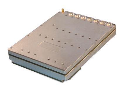
NAL Technologies (Naltec), a provider of assured positioning, navigationand timing (APNT) solutions, has added to its Alternative Location and Timing Module (ALTM) family with ALTM-T. The ALTM-T module is engineered for applications and infrastructure demanding precise location, timing and synchronization redundancy with other APNT sources.
Critical network infrastructure — power grids, financial markets, transportation, data and centers — are heavily reliant on GNSS/GPS signals where precise timestamps, synchronization and transaction integrity, and operational continuity are key.
ALTM-T is an ultra-low size, weight and power (SWaP) receiver ptimized for precision timing at <50ns RMS. It also conforms to the M.2 3042 B-key standard form factor and uses less than 600MW consumption, making it suitable for SWaP-constrained systems.
“APNT technology complements GNSS/GPS, which is the invisible backbone of modern infrastructure,” said APNT Solutions Director, Rob Gillette, NAL Technologies. “Without additional timing sources such as APNT by Naltec, a failure of GNSS/GPS can trigger consequences that could cascade rapidly across utilities, transportation and financial markets. With ALTM-T, users will benefit from enhanced performance delivered from APNT by Naltec, to ensure resilient precision timing synchronization.”
The embeddable ALTM-T receiver leverages the Iridium PNT signal to provide a complementary APNT source that is approximately 1,000 times stronger than GNSS/GPS. The APNT signal can penetrate indoor environments as well as mitigate intentional and unintentional GNSS interference for ultimate reliability.
Naltec provider of Iridium PNT-enabled modules, with more than 13,000 receivers deployed since its first ALTM launch in 2019. ALTM-T is commercially available and now shipping.
Successful deployment at APEX validates the technology as a crucial inertial-sensor stack for assured PNT on the modern battlefield.
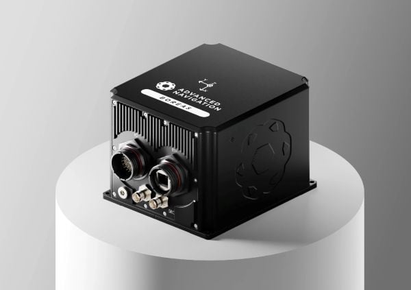
Advanced Navigation successfully demonstrated in April 2025 its inertial-centric intelligent navigation as part of the U.S. Army’s All-Domain Persistent Experiment (APEX), underscoring the ability to deliver reliable, high-accuracy navigation in GNSS-degraded and -denied conditions.
Designed for the DDIL (Degraded, Denied, Intermittent and Low-bandwidth), APEX provided Advanced Navigation with an operationally relevant testbed to evaluate the performance of its Boreas D90 fiber-optic gyroscope (FOG) inertial navigation system (INS) when fused with complementary aiding sensors, including the laser velocity sensor (LVS) and a wheel-speed encoder. The results reaffirm Advanced Navigation’s intelligent software-defined approach as a resilient foundation for APNT on the modern battlefield.
“Assured PNT is non-negotiable. The only path to operational advantage is an intelligent, multi-sensor fusion anchored by a resilient inertial core. We deliver this with our sophisticated AdNav Intelligence software,” said Chris Shaw, Advanced Navigation CEO. “Now in our third year participating in this U.S. Army program, APEX continues to challenge our systems under realistic electronic warfare conditions.”
Boreas D90. At the center of the architecture is the Boreas D90, a strategic-grade FOG INS that serves as the “nervous system” of the navigation stack. Unlike conventional systems reliant on GNSS or magnetic compasses, Boreas D90 determines true North through gyrocompassing, using ultra-sensitive fiber-optic gyroscopes to detect the Earth’s rotation. This enables independent, high-confidence navigation, even when external GNSS signals are compromised.
AdNav Intelligence. AdNav Intelligence software continuously validates all sensor inputs, adjusts in real-time to the operational environment, and autonomously counteracts spoofing and jamming. The sophisticated software can adapt in real time to respond to incoming threats, dynamically weighing the input from each sensor to make real-time adjustments on which sensor to rely on based on their reliability scores, environmental conditions, and operational context.
Demonstration setup
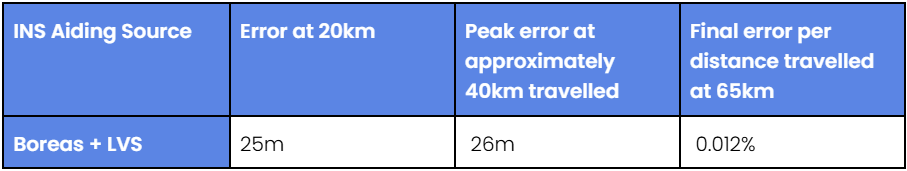
During APEX, Boreas D90 with AdNav Intelligence was integrated with both a laser velocity sensor and a wheel-speed encoder aboard a four-wheel-drive vehicle. The demonstration was conducted during night operations at a site in rural New Mexico, under a created environment of complex and emerging electronic warfare threats with GNSS jamming.
The Boreas D90 was fused with Advanced Navigation’s advanced infrared laser sensor that measures ground-relative 3D velocity with exceptional precision. LVS performs reliably on both ground and airborne platforms regardless of environmental conditions or the availability of visual references, as long as it maintains a clear line of sight to the ground or a stationary surface. By providing direct, drift-free velocity measurements, the LVS ensures continuous, high-precision mobility and enhances navigation resilience even in the most extreme contested GNSS environments.
This configuration demonstrated dead-reckoning accuracy, achieving a 0.012% error per distance traveled (7.5 m over 65 km) in the same contested conditions.
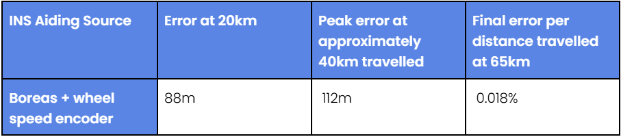
Wheel-speed encoder. Wheel-speed encoders offer a rugged and cost-effective source of motion data, measuring wheel rotation to determine ground speed and distance traveled. Their design ensures quick integration across tactical platforms. Ideal for firm terrain and structured routes, they provide dependable dead-reckoning performance when GNSS is denied, making them a practical choice for missions that demand reliability over complexity.
When paired with a wheel-speed encoder, the Boreas D90 delivered reliable dead-reckoning performance useful for platforms operating in predictable or structured environments. Across the demonstration, the Boreas D90–wheel-encoder configuration maintained strong navigation continuity, achieving a 0.018% error per distance traveled (11.7 m over 65 km), without reliance on GNSS, even under deliberate jamming.
Next Steps for APNT
For Advanced Navigation, the results from APEX show significant potential for a range of current and future defense applications. The technologies exceeded the team’s expectations, demonstrating the level of accuracy and operational reliability required for successful navigation under GNSS-denied and -degraded conditions.
Integrating INS with next-generation photonics promises to further advance capability, resilience and adaptability on the battlefield, Advanced Navigation said.
About the U.S. Army’s APEXevent
Previously known as the Positioning, Navigation, and Timing Assessment Experiment (PNTAX), the sixth annual APEX event was held at the U.S. Army’s premier military test range, designed to replicate the complex, contested conditions that forces are expected to face in future multi-domain operations.
The next experiment will include partners within the United States Air Force’s 746th Test Squadron and the Joint Navigation Warfare Center, U.S. Army Combat Capabilities Development Command, and the Army Test and Evaluation Command. Advanced Navigation expects to take part 2026.
APEX provides a rigorous environment for evaluating mission resilience across a broader spectrum of technologies. While resilient PNT remains a core component, the event extends to integrated sensing capabilities, advanced communications architectures, data transport, and edge processing. These systems are evaluated under threat-informed, operationally realistic scenarios that reflect the evolving demands placed on modern military platforms in GPS-degraded or -denied environments.
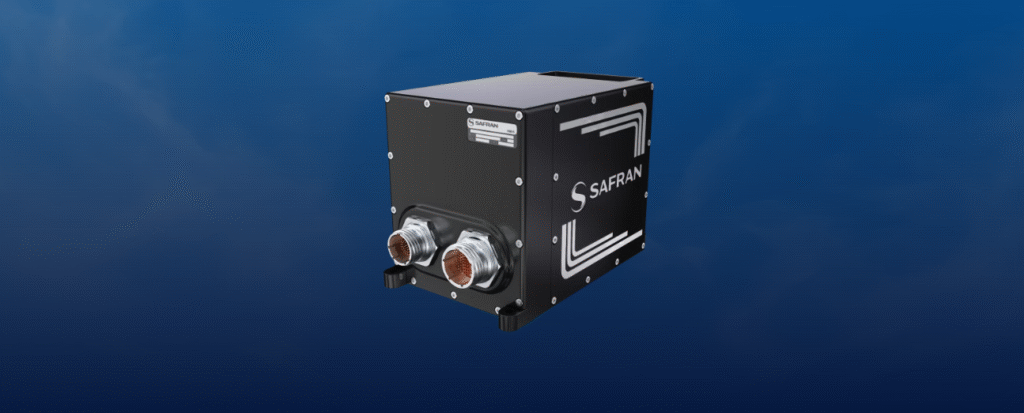
Skynaute is a hybrid inertial/GNSS navigation system based on HRG Crystal technology. It will serve as a critical component of the Hercules avionics suite designed and integrated by Moog.
The Skynaute navigation unit by Safran. (Photo: Safran Federal Systems)
Under this agreement, Safran Federal Systems will supply Skynaute units to support enhanced navigation performance in demanding operational environments.
“Being selected by Moog underscores the reliability, innovation, and mission readiness of our Skynaute solution,” said Tony Full, senior director of Business Development, Navigation Systems, Safran Federal Systems. “This collaboration continues our tradition of delivering precise, resilient navigation technologies to meet the evolving needs of military aviation.”
Skynaute is engineered to meet the needs of both legacy and next-generation military aircraft, providing superior accuracy and robustness with minimal size, weight, and power consumption. The system is suited for retrofit and modernization programs, particularly for platforms like the Hercules that remain integral to global air mobility and tactical transport operations.
Safran Federal Systems supports Safran Defense & Space Inc. (Safran DSI) by providing APNT technologies across a range of defense and aerospace applications.
Advanced Navigation has finalized a multi-million deal with Kongsberg Defence & Aerospace to supply more than 50 Boreas D90 fiber-optic gyroscope inertial navigation systems (FOG INS) to strengthen Kongsberg’s Protector RS4 in high-threat, contested environments.
As a strategic-grade INS, the Boreas D90 is engineered for the world’s most extreme environments, maintaining exact targeting and unwavering line-of-sight control for the Protector RS4.
The Boreas D90 was selected not only for its superior precision in GNSS-denied conditions, but also for Advanced Navigation’s proven capacity to meet demanding delivery timelines. This agility is made possible by the company’s state-of-the-art, vertically integrated manufacturing. By controlling the entire production process, from sourcing raw components to assembly and testing in simulated EW environments, Advanced Navigation can rapidly scale output on demand and guarantee schedule certainty, a critical factor for Kongsberg.
The Protector RS4 remote weapon system. Photo: Kongsberg)
The Protector RS4 is the world’s most fielded remote weapon system, deployed across more than 30 nations and multiple domains. The highly flexible, modular system is designed to integrate a diverse range of payloads, including small and medium caliber systems and guided effectors. Its advanced, modular sensor suite (day, night, LRF) provides exceptional and customizable situational awareness.
The fully stabilized 2 + 2 axis (detached line of sight) system allows the operator to maintain focus on a point of interest, independent of platform movement or the delivery solution for the specific system in use. The Protector RS4 is platform-independent and suitable for both land and sea applications.
By integrating Boreas D90, the Protector RS4 achieves a new level of precision and survivability, sustaining locked targeting and georeferenced stability even when GNSS is compromised or denied. This enhancement positions Kongsberg’s Protector RS4 as one of the few systems globally capable of maintaining precision pointing under active electronic warfare attack.
The deal supports the Global Supply Chain (GSC) Program, an initiative by the Australian Department of Defence designed to connect local suppliers with major global defense prime contractors. Advanced Navigation is based in Australia; Kongsberg is based in Norway.
NAL Research is partnering with SGM Technology, a maritime technology company, and Tschudi Shipping, a maritime logistics company, to deliver a resilient navigation and tracking product line for the commercial shipping industry enabled by Iridium’s low-Earth orbit (LEO) satellite network.
NAL Research is a U.S.-based firm specializing in assured positioning, navigation and timing (APNT) solutions.
The partnership aims to provide reliable asset tracking and assured navigation in high-risk maritime environments. Threats to GPS and GNSS signals — such as jamming, spoofing and interference — are reaching unprecedented levels worldwide. In some regions, maritime authorities reported a 350% increase in affected vessels over the past six months, according to NorthStandard. These disruptions are leading to serious consequences, including collisions, delays, financial impacts on global trade, and heightened security risks for crews at sea.
Under the partnership agreement, the companies are leveraging NAL Research’s 25+ years of expertise in APNT, tracking, and connectivity to develop solutions built on the Iridium PNT service, a powerful and fully authenticated L-band signal resilient to spoofing and jamming.
The partnership will also benefit from SGM’s 15+ years of experience delivering technology to the commercial maritime sector and Tschudi Shipping Company’s global presence and 140+ years in commercial shipping and logistics. Together, the collaboration aims to provide maritime users with unmatched resilience and reliable navigation for GPS/GNSS-compromised environments. Trials of this state-of-the-art solution are underway.
All three organizations are United Nations agencies and have previously issued similar statements independently. This is the first time they have spoken on this in one voice.
In 2020, ICAO issued a letter to all member states urging them to “strengthen CNS systems resilience and mitigate interference to GNSS.” It contained 13 recommendations resulting from three different work streams within the organization. The last of the recommendations was “… to support the multi-disciplinary development of alternative positioning, navigation and timing (APNT) strategy and solutions to complement the use of GNSS in aviation in coordination with ICAO and airspace users.”
In 201, IMO issued a circular on deliberate GNSS interference.. It called on nations to prevent interfering transmissions coming from their territories, issue warnings about known interference, and consider taking actions to prevent unauthorized interfering transmissions.
This ITU circular urged nations to “address the critical issue” by:
Reinforcing navigation systems’ resilience to interference.
Increasing collaboration between radio regulatory and enforcement authorities.
Reinforcing civil-military coordination to address interference risks associated with RNSS testing and conflict zones.
Increase coordination between aviation, military and radio-regulatory authorities.
Retain essential conventional navigation infrastructure for contingency support in case of RNSS outages and develop mitigation techniques for service loss.
A resolution by ITU’s 2023 World Radiocommunications Conference echoed similar themes. Still, it was criticized because its cautions and prohibitions came with the caveat, stating “…without prejudice to the right of administrations to deny access to the RNSS, for security or defense purposes.”
Many observers opined that there are few reasons for nations to interfere with GNSS other than security or defense concerns, which allows malicious actors to have carte blanche. Furthermore, it was suggested that the resolution might have included language to ensure that security and defense-related disruptions do not extend beyond a nation’s borders or similar provisions.
While no specific events are cited in the statement as motivating its publication, the death on Christmas Day of thirty-nine people aboard an Azerbaijan Airlines flight could have been the reason. The aircraft was approaching a Russian airport during an intentional interference event and was apparently misidentified by Russian forces. It was subsequently damaged by ground fire and crash-landed in Kazakhstan.
The recent joint statement cites, among other international agreements and actions, the ITU Constitution, which says, “All stations, whatever their purpose, must be established and operated in such a manner as not to cause harmful interference to the radio services or communications of other Member States.”
The joint statement concludes with:
Therefore, ITU, ICAO and IMO jointly and urgently call on their respective Member States to:
Protect the RNSS from transmissions that can adversely cause harmful interference, degrading, interrupting, or misleading signals used for civilian and humanitarian purposes.
Reinforce the resilience of the systems that rely on RNSS for navigation, positioning, and timing in relation to this type of interference.
Retain sufficient conventional navigation infrastructure for contingency support in case of RNSS outages and misleading signals, and develop mitigation techniques for loss of services.
Increase collaboration between radio regulatory, civil aviation, maritime, defense and enforcement authorities.
Report cases of harmful interference affecting RNSS to the appropriate telecommunication, aeronautical, and maritime authorities and the ITU Radiocommunications Bureau to enable the monitoring of the situation.
The United Nations and its agencies are collaborative bodies that operate by consensus and through the cooperation of members. As such, they have no ability to enforce standards or compel compliance with recommendations.
Advanced Navigation, Hanwha Aerospace and Hanwha Defense Australia (HDA) have signed a memorandum of understanding (MoU) to co-develop strategic grade assured positioning navigation and timing (APNT) solutions.
Under the agreement, the three companies will collaborate on the development of high-performance inertial navigation systems (INS) for autonomous, airborne, and crewed systems. These systems will be used for precision targeting and vehicle navigation in GNSS-contested environments across land and air domains.
The co-developed solutions will be integrated into Hanwha Aerospace’s global supply chain to advance the broader strategic APNT interests for Australia and international markets.
By integrating Advanced Navigation’s IP in digital fiber-optic gyroscope (DFOG) technologies with Hanwha’s robust aerospace and defense capabilities, the agreement seeks to augment Australia’s manufacturing and supply chain resilience to meet the demand of global military supply chains.
Hanwha Defense Australia’s Armoured Vehicle Centre of Excellence (H-ACE) in Melbourne, Australia, will provide critical facilities supporting the production and sustainment of tracked armored vehicles, including multiple assembly lines, a 1,200 m test track, a deep-water test facility, an obstacle course and a research and development center. Stage 2 of the development will also include Australia’s EMI/EMC (electromagnetic interference/compatibility) chamber and test shooting tunnel alongside an expanded manufacturing capability.
In the neighboring state of New South Wales, Advanced Navigation’s manufacturing facility will be used for the secure production of APNT solutions. Specifically, it enhances the critical output of strategic-grade DFOGs, which possess the heightened sensitivity necessary to detect the Earth’s rotation.
How do/will/should North Atlantic Treaty Organization (NATO) forces integrate GPS and Galileo for position, navigation and time?
Ellen Hall
“For improved resiliency, it would be a great move for NATO to integrate Galileo with GPS into their system. The ‘how’ will be difficult. Some of the challenges are that the EU consists of more than a single nation with which to negotiate complex security issues, such as whether NATO will be treated as a ‘third nation entity’ for the use of PRS. The initial Galileo development was difficult for all these reasons and the Europeans managed to sort it all out, so I’m confident that, if the desire is to do this, it can be done successfully.”
— Ellen Hall Imminent Federal
John Fischer
“In the interest of operational robustness and the criticality of the use case, NATO should integrate GPS and Galileo capability at the earliest. Both GPS’ M-code and Galileo’s PRS are encrypted, providing anti-spoof capability and extra frequency diversity, making jamming of our forces more difficult. Crypto key management for both systems may be an extra burden, but a single receiver capable of operating with either system individually or both simultaneously would be key for interoperability — always a driving factor for NATO. The capability is available, and NATO should take advantage of it.”
Artists rendering of the B-21 raider, which is being produced by Northrup Grumman for the U.S. Air Force to operate in tomorrow’s high-end threat environment. (Image: U.S. Air Force)
With assured positioning, navigation and timing (APNT) and low-Earth orbit PNT (LEO PNT) coming on strong, what does the future hold for military and commercial systems dependent on the current configuration of GPS? Should military and commercial platforms be modified to include APNT, for now, with an eye to adding LEO PNT in the future? Should they integrate these two systems, or rely on one or the other as standalone systems?
Government and industry agree that interference with GPS and all GNSS is an increasing threat as jamming and spoofing technologies evolve. This has prompted government support for APNT to bolster GPS. A Feb. 12, 2020, Executive Order required a comprehensive update to national policy on PNT services by the federal government, and by owners and operators of critical infrastructure to strengthen the resilience of critical infrastructure.
Research, development and production have improved the performance — positioning, timing and (desired) accuracy — of GNSS PNT and the ability to operate in RF-challenged environments. APNT gives the U.S. military a reliable way to further enable GPS, or to act as an alternative to it, by utilizing other sensors, such as inertial navigation systems, differential GPS, visual sensors, lidar, radar, radios and star trackers that complement GPS.
The near-term expansion of internet service to include commercial broadband LEO satellites also provides potential for robust PNT, using their waveforms as signals of opportunity (SOOP). GPS and other GNSS have an infrastructure to maintain very precise time throughout their constellations, as well as satellites with specially designed transmitters, clocks, and a waveform dedicated to the PNT function. By contrast, SOOPs are in space for another purpose and not optimized for PNT. Therefore, the challenge is to exploit features of the SOOP waveforms, designing innovative techniques to determine the range to each satellite and to provide users with reliable PNT. The approach for LEO PNT may have applications to ground troops and for aerial, munition, missile and commercial applications requiring higher levels of PNT security and integrity.
GPS receivers for future military platform designs may use a software defined radio (SDR) approach and be capable of incorporating LEO PNT signals. This technology, although designed to work standalone, can be used to complement existing navigation sensors that are typically used in navigation systems, including APNT. Expansion to the usage of multiple constellations will serve to optimize performance and resiliency in an RF-challenged environment. However, LEO satellites’ closer proximity to Earth and their signal structures allow for higher signal powers, thus are more robust against jamming. With all these separate systems or fusion by SDR, how does the receiver ensure the integrity of the signal or its accuracy? An SDR qualification test would involve an unlimited number of scenarios.
One hallmark of the GPS program is that it facilitates a thorough systems engineering effort by managing in a single location interface control documents (ICDs) for alternative systems being developed by different program offices all over the country. This makes both the integration of the systems and the development of the receivers extremely difficult and complex.
“The new SPD-7 [Space Policy Directive 7, the United States Space-based Positioning, Navigation and Timing Policy, dated Jan. 15, 2021] focusing on interoperability and APNT is a seminal document to address a realized threat and a way forward,” said Bernie Gruber, a former head of the GPS Directorate (now the Military Communications and PNT Directorate). “To that end, the combination of SDRs and data fusion potentially offer a clear advantage to utilize signal and sensor diversity, thus improving the robustness of critical PNT information.”
A roundup of recent products in the GNSS and inertial positioning industry from the August 2022 issue of GPS World magazine.
OEM
Receiver Module
Designed for autonomous applications
Photo: Trimble
The Trimble BD9250 dual-frequency receiver module supports Trimble RTX correction services and is designed to deliver high-accuracy positioning for high-volume, autonomous-ready applications in agriculture, construction, robotics and logistics. The compact receiver has an industry-standard form factor and pinout, allowing for easy system integration and configuration. Equipped with Trimble’s advanced ProPoint positioning engine, the BD9250 delivers robust and accurate positioning. It is compatible with Trimble RTX correction services or real-time kinematic (RTK) and supports GPS, Galileo, GLONASS and BeiDou as well as QZSS and NavIC. Support for the Indian NavIC S-Band signal is also available.
The AsteRx-U3 ruggedized GNSS receiver is the successor to the AsteRx-U for construction, mining and other machine control applications. It combines a triple-band precise positioning GNSS core with extended wireless communication features including Wi-Fi, UHF and 4G LTE, making it easy to fit it into any control system. The AsteRx-U3 offers low latency of under 10 msec with a high data rate, which allows machines to work rapidly and accurately. An IP68-rated housing, with fixing brackets and robust M12 connectors, enables quick installation.
The M20071 integrated GNSS receiver module, measuring 9 x 9 x 1.8 mm, incorporates the MediaTek AG3335MN flash chip. The receiver tracks four GNSS constellations concurrently (GPS + Galileo + GLONASS + BeiDou). The 1.8-volt system power supply provides outstanding low power consumption. Its multipath algorithms improve position accuracy in inner-city environments. The onboard low noise amplifier provides good performance in weak signal environments such as wearable devices.
The Strategic Anti-jam Beamforming Receiver – M-Code (SABR-M) enables precise geolocation and strike capabilities in highly contested battlespaces. It integrates receiver technology with advanced antenna electronics in a small, hardened package designed to meet challenging performance requirements. It delivers accurate position, velocity, altitude and timing data, as well as strong protection against GPS signal jamming and spoofing. At 4.5 x 6 x 1 inches, the SABR-M meets size, weight, power, cost (SWaP-C) and thermal requirements for space-constrained military applications. It uses advanced beamforming technology to improve GPS signal reception and counter threat signals.
The GPS Resilient Kit (GRK) is a cybersecurity device that comes with two antennas for monitoring and protecting time-critical infrastructures. It can be integrated with any GNSS receiver, either as a retrofit or in greenfield deployment. The GRK features a proprietary interference filtering algorithm for maximum protection, up to 40-dB attenuation of jamming signals with the premium option. It requires minimal power consumption while providing cloud-based monitoring with real-time reporting of jamming attacks. It protects GPS L1 (C/A code) with a latency of 100 ns ±15 ns (fixed).
GBaaS enables providers to combat PNT cyberattacks
Photo: ADVA
GNSS-backup-as-a-service (GBaaS) enables service providers to help operators safeguard services that rely on positioning, navigation and timing (PNT). In-network timing based on network time protocols (NTP) and precision time protocols (PTP) are also increasingly vulnerable to cyber threats. GBaas is based on ADVA’s aPNT+ platform, which leverages a suite of technologies, including multi-band GNSS receivers and management software based on artificial intelligence and machine-learning. Service providers can offer ADVA’s aPNT+ protection as a subscription-based service as part of their service-level agreements.
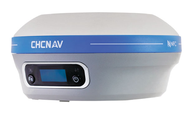
The i73+ pocket-sized receiver is a powerful and versatile receiver with an integrated UHF modem that delivers survey-grade accuracy in all jobsite configurations. It has 624 GNSS channels and the latest iStar technology and can be operated as either a base station or a rover. The i73+ is a highly productive NTRIP rover when used with a handheld controller or tablet and connected to a GNSS RTK network via CHCNAV LandStar field software. The receiver takes advantage of GPS, GLONASS, Galileo and BeiDou, in particular the latest BeiDou 3 signal, to provide robust data quality at all times.
The Geode GNS3 GNSS receiver allows users to collect real-time GNSS data with sub-meter, sub-foot and decimeter accuracy options. With a scalable accuracy platform, users can purchase what they need now, while having the option to increase accuracy in the future. It offers sub-meter accuracy with a single-frequency antenna, while its multi-frequency antenna supports all constellations on L1, L2 and L5. Atlas L-band corrections allow the Geode to be used in water utility locating, agriculture and irrigation mapping, as well as mapping projects in remote locations where other correction services are not available. The Geode GNS3 can be used with Windows, Android, iPhone and iPad devices.
Improved colorization to contextualize point clouds
Photo: GeoSLAM
The ZEB Vision is a camera accessory for the ZEB Horizon system that can be used to capture 360° panoramic photography in 4K definition for point cloud colorization. Data is captured as the user walks through the area of interest. The ZEB Vision uses GeoSLAM’s SLAM algorithm to automatically and accurately position panoramic photos on a point cloud for an interactive viewing experience. The ZEB Vision attaches easily to the ZEB Horizon. The 4K resolution increases feature definition of objects within the point cloud, allowing for a new perspective on data by navigating within a virtual representation of an environment. This means industries such as architecture, construction and facilities can add real-world context to point clouds for the creation of CAD/BIM models.
The Leica Chiroptera-5 is a high-performance airborne bathymetric lidar sensor for coastal and inland water surveys. It combines airborne bathymetric and topographic lidar sensors with a four-band camera to collect seamless data from the seabed to land. Compared to previous models, the Chiroptera-5 provides 40% higher point density, a 20% increase in water-depth penetration, and improved topographic sensitivity for generating more detailed hydrographic maps. Its high-resolution lidar data supports nautical charting, coastal infrastructure planning, environmental monitoring and landslide and erosion risk assessments.
The Clirio application combines mobile lidar 3D scanning with smart remote collaboration tools to offer teams an end-to-end 3D solution to capture, organize, share and problem-solve. This is all based on real-time field observations and data, whether team members are on site or a continent away. Clirio is a set of mobile, web and VR/AR apps for instantly capturing, sharing, reviewing and resolving worksite field observations. At a field site, Clirio users collect notes, photos and 3D scans (using the laser scanner built into a new iPad Pro or iPhone Pro). These field observations are automatically geo-referenced within the map-based workspace and synced to a secure cloud workspace. An intuitive interface allows colleagues, managers, partners, or stakeholders to sort, review, compare, and act on field observations.
The Visual Parking System (VPS) by Bird is designed to keep track of scooter parking in a scalable, efficient and vandalism-immune way that requires zero infrastructure within a community. Powered by Google’s ARCore Geospatial API, VPS enables scooter parking with pinpoint accuracy. When parking a scooter, riders will be prompted to take a quick scan of their surroundings. The system seamlessly compares a rider’s images against Google’s data and Street View images in real time to produce the best available parking solution. Stationary objects such as buildings and signs are used as reference points, while more dynamic objects such as people and vehicles are disregarded. The near-instantaneous process results in a precise, centimeter-level geolocation that enables Bird VPS to detect and prevent improper parking with extreme accuracy, helping ensure Bird vehicles are only left in approved areas.
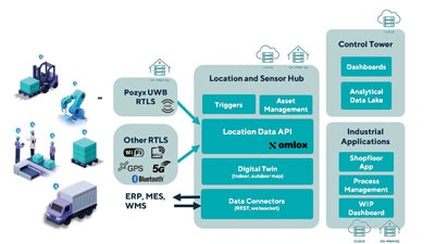
Supports Industry 4.0 with real-time visibility of assets
Photo: Pozyx
The Pozyx Platform is an asset tracking and identification solution for seamless indoor and outdoor tracking, following packages or other assets from trucks to their destination. It is based on the omlox hub, an open standard for real-time location systems that combines GPS data with data from ultra-wideband, 5G, radio-frequency identification, Wi-Fi and Bluetooth. The Pozyx Platform offers a seamless indoor/outdoor transition with zoom-in from a worldwide map to a detailed indoor map, showing highly accurate locations up to 10 cm. It is designed for smart manufacturing, providing a supply-chain solution that supports Industry 4.0. It tracks and identifies any asset, providing real-time data to facilitate warehouse and inventory control, keep track of critical tools, and slash lost asset costs.
The May 4-5 meeting of the National Space-Based Positioning, Navigation and Timing Advisory Board focused on its mantra to “protect, toughen and augment” (PTA) GPS. The meeting included three great presentations that bear directly on the A of that mantra.
CAST
The electric grid used to be simpler: regional operators flowed power unidirectionally from stations to customers basing the load on past usage. Now, the grid is becoming a wide-area network — with regional inter-connects, multi-directional flows, and load based on real-time data and predictive analysis, requiring sensors time-synchronized within 1 microsecond from UTC. Yet, this critical infrastructure’s timing applications depend entirely on vulnerable GPS technology.
“If we can provide an authoritative, trusted synchronization source across the interconnected grid, its operators have a much better opportunity to understand the interdependencies and movement of power across their networks,” said Carter Christopher of Oak Ridge National Laboratory. He described the lab’s Center for Alternate Synchronization and Timing (CAST), which provides a redundant and resilient satellite-based service backed up by a network of terrestrial master clocks. CAST is precise, traceable and secure from jamming, spoofing, cyberattacks and physical attacks.
HARS
Attila Komjathy and Larry Romans of NASA’s Jet Propulsion Laboratory (JPL) proposed a GPS high-accuracy and resilience service (HARS) based on global differential GPS (GDGPS). It would provide corrections to GPS orbit and clock errors, and encrypted navigation data bits over the internet. It would match Galileo in accuracy, they said, pointing out that Galileo, QZSS and BeiDou provide high-accuracy services in their broadcast signals. HARS would improve the accuracy of consumer GPS receivers of 3–5 m to 1 m and help ensure that multi-constellation GNSS chips would continue to rely on GPS first.
HARS could be implemented by having commercial providers—such as Apple, Google and cellular carriers—distribute GDGPS corrections generated by JPL and supported by government partners. Private industry, Komjathy and Romans pointed out, provide service for RTK, centimeter and decimeter apps, but only governments (the U.S. Coast Guard’s DGPS service and Galileo’s HAS) provide corrections for about one-meter accuracy. Therefore, HARS would not compete with industry and would create additional opportunities for it to create value-added products.
αPNT
David Castiel and Cyrus Langroudi, of Virtual Geosatellite LLC, proposed αPNT, a virtual geostationary satellite system with elliptical orbits that would provide active PNT in a distributed architecture integrated with a blockchain. The system, they said, would be able to provide very accurate geographical position, precise timing and guidance with a minimum number of satellites on the horizon. It would rely on two-way links between transceivers and satellites to protect against jamming or spoofing.
While GPS’s success makes it a critical and ubiquitous infrastructure, its vulnerabilities require and stimulate exciting new R&D. Stay tuned.
Hexagon | NovAtel’s GAJT-710ML installed on a U.S. Army vehicle. Photo: U.S. Army Futures Command
We asked Dean Kemp, Ph.D., director of Marketing, Aerospace and Defense for Hexagon’s Autonomy & Positioning division, a few questions.
How do jamming and spoofing threats change?
Jamming and spoofing methods change as new interference-causing technologies become available. As such, it’s vital for us to continuously evaluate potential sources of threats and provide the highest possible level of resiliency to interference in our solutions.
Have new threats emerged in the past six weeks in connection with Russia’s invasion of Ukraine?
Evidence is emerging that electronic-warfare systems capable of high-power jamming and spoofing across wide areas are being used within Ukraine. Fortunately, there have been no known impacts on allied forces. However, knowing that the technology is in place and in use highlights the importance of assured positioning, navigation and timing (APNT) and our contribution to building resiliency in allied forces’ equipment against the potentially destabilizing effects of jamming and spoofing.
How do you define APNT?
We use APNT to describe measurements that are always accurate, available and reliable. Our anti-jamming, anti-spoofing and other resilience-building capabilities provide trusted and available PNT information at the level of accuracy requested.
When did you introduce GPS Anti-Jam Technology (GAJT)? How do you define it?
GAJT was introduced in 2011 and is our leading APNT solution. GAJT units are utilized worldwide across land, sea and air, with rapid deployment supported by commercial off-the-shelf solutions and short lead times. GAJT provides jamming protection of satellite-based navigation and precise timing receivers from intentional jamming and unintentional interference whatever your application. Product variants provide features to best support anti-jamming capabilities for the warfighter, national infrastructure, low-SWaP platforms and other mission-critical applications.
What are the key differences between the GAJT-710ML, the GAJT-710MS and the GAJT-410MS?
The GAJT-710 is designed for land vehicles (ML variant) and marine vessel platforms (MS variant) with up to six simultaneous nulls to protect against jamming signals and interference. The next generation of GAJT-710 includes jammer direction-finding and a silent mode to reduce its thermal signature. The GAJT-410 maintains the high levels of interference-rejection performance in the 710 but in a lower size, weight and power (SWaP) design, with three simultaneous nulls, for both land and marine variants. It also utilizes a single RF cable to provide clean power, data and protected GPS signal. The GAJT-410 enables APNT while also reducing the need for platform modifications or armor penetration.
The GAJT-AE extends jamming and interference protection to unmanned and autonomous applications. Using an external CRPA antenna, the GAJT-AE offers flexibility of integration into space-constrained platforms.
Is the GAJT-AE-N Anti-Jam Antenna receiver-agnostic?
We designed our GAJT product line to be receiver-agnostic and compatible with legacy and modern GNSS receivers. This flexibility results in GAJT being ideal for civil and military applications, including SAASM and M-code systems.
How does your GNSS Resilience and Integrity Technology (GRIT, launched in 2020 November) relate to your GAJT antennas?
GRIT is a firmware suite for our OEM7 receivers that expands their situational awareness and interference mitigation tools. GRIT includes our Interference Toolkit (ITK) along with spoofing detection to identify when your GNSS signal may be under threat. It also empowers the user to develop interference location algorithms through time-tagged snapshots of data samples to characterize the RF environment around your operations. GRIT, alongside GAJT, forms the foundation of our APNT strategy in providing accurate and always-available PNT.
Do you have any recent contracts with the U.S. Department of Defense or the militaries of other NATO countries to supply GAJT antennas?
Our GAJT product portfolio has been sold in large quantities to military and civil organizations for many years, successfully proving itself in the field. In 2020, we achieved a milestone of more than several thousand units shipped worldwide, making it one of Hexagon | NovAtel’s more successful years.