Space Systems Command (SSC), the National Reconnaissance Office (NRO), United Launch Alliance (ULA) and their mission partners successfully launched the “Silent Barker”/NROL-107 mission aboard an Atlas V rocket September 10, 2023, at 8:47 a.m. EDT from Space Launch Complex (SLC)-41 at Cape Canaveral Space Force Station, Florida.
The spacecraft was part of the Space Force’s Silent Barker satellite constellation network intended to provide space situational awareness, orbital surveillance and tracking.
According to a statement by ULA, Silent Barker is designed to detect and maintain custody of space objects. This capability enables indications and warnings of threats against high-value assets in geosynchronous orbit.
The mission aims to serves the needs of the U.S. Department of Defense and intelligence community by providing the capability to search, detect and track objects from a space-based censor for timely custody and event detection, the company said.
Surveillance from space allows the government to overcome existing ground sensor limitations and will enable the collection of timely satellite metric data around the clock.
One more Atlas V 551 remains in the NSSL inventory as the Space Force approaches the end of Atlas.
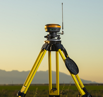
The S631 smart antenna on a tripod. (Photo: Hemisphere GNSS)
Hemisphere GNSS distribution agreement with Volvo Construction Equipment to provide new S631 GNSS survey smart antenna
Volvo Construction Equipment North America will add the Hemisphere GNSS S631 Survey Smart Antenna to its marketplace portfolio for Volvo CE dealers and end users. The new S631 adds robust performance and high precision in a compact and rugged package.
The distribution agreement with Volvo CE expands Hemisphere GNSS’s list of partners offering Hemisphere’s latest technology for machine control products and solutions.
The addition of the Hemisphere GNSS S631 Survey Smart Antenna aligns with Volvo CE’s focus on the latest technology and solutions for machine control applications, the company said.
“Partnership between Hemisphere and Volvo Group companies goes back 15 years when we began to provide Volvo Penta our heading units for marine applications,” said Randy Noland, VP Global Sales and Business Development at Hemisphere. “That business provided a technological foundation between our two organizations that eventually brought us together again with Volvo CE as a provider of high-precision, rugged GNSS receivers for machine control for use in Volvo Co-Pilot products. We are pleased the partnership continues to grow, with additional GNSS receivers now available as an extended offering through Volvo CE North American dealers. We greatly value our relationship.”
About the S361 Smart Antenna
The S631 provides robust performance and high precision in a compact and rugged package. With multiple wireless communication ports and an open GNSS interface, the S631 can be used in a variety of operating modes, as a rover or base station.
The built-in web user interface (WebUI) can be used to control and manage the receiver status and operation, as well as to upgrade the S631 with new firmware and activations.
Corrections. S631 is Athena-enabled and Atlas-capable (subscription required). With Athena, S631 provides precision RTK performance when receiving corrections from a static base station or network RTK correction system. With multiple connectivity options, the S631 allows for RTK corrections to be received over radio, cell modem, Wi-Fi, Bluetooth or serial connection.
The S631 receiver also enables users to work with Atlas, Hemisphere’s global correction service. Atlas delivers worldwide centimeter-level correction data over L-band communication satellites.
Key Features
Multi-frequency GPS, GLONASS, BeiDou, Galileo, QZSS, IRNSS and Atlas L-band
Long-range RTK baselines up to 50 km with fast acquisition times
UHF (400 MHz and 900 MHz), cellular, Bluetooth and Wi-Fi wireless communication
Athena GNSS engine for precision RTK performance
Internal sensor corrects collected point coordinates to within 2 cm
SPH Engineering has partnered with Daewoo Engineering and Construction (E&C). Through the partnership, SPH will support Daewoo’s data management projects through its Atlas artificial intelligence (AI) platform, which enables aerial imagery storage, map creation, change tracking, object detection and territory segmentation.
Photogrammetry data is expected to become one of the key components for storage and processing, SPH added.
According to the companies, Atlas will enable Daewoo Engineering and Construction to set up an online archive of drone imagery and photogrammetry products, track changes and generate reports, automate object detection and measure the identified objects of interest. The platform also will increase data availability for participants of construction workflow.
“Atlas can be definitely used in various fields, but it will be a groundbreaking platform, especially in the field of construction survey,” said Geunmok Song (Alex), digital construction team manager at Daewoo Engineering and Construction.
“When we introduced Atlas back in spring, first of all we wanted to support our existing UgCS customers with an easy-to-use AI tool to store and process data collected with our software integrated to a UAV,” said Alexei Yankelevich, R&D director at SPH Engineering. “We are proud that Daewoo Engineering and Construction, the representative of Korea, has opted for our solution.”
BRING YOUR OWN DEVICE (BYOD) is not just an industry buzzword. It can change the way professional surveyors work every day. The idea of using a smartphone or tablet instead of a dedicated device is appealing. But is it good enough?
Surveyors and mappers are challenged with the arduous task of data collection that meets accuracy and precision standards and provides adequate attribute information for the project. Before the invention of the electronic data collector, handwritten notes in field books were the norm. Every note keeper’s style varied in content, neatness and thoroughness. Calculations for determining survey data values were completed longhand on paper and were very time consuming.
Like its personal computer counterpart, the electronic data collector was introduced in the late 1970s with minimal adoption by the average surveyor because of cost and complexity. Storage methods for the era included magnetic modules and tape; both forms of media were expensive and fragile with little storage for the cost.
Data collection was limited to numeric values only, with horizontal and vertical angles, slope distance, point number and point code being the extent of the information. Couple this process with the limited availability of printers and plotters capable of depicting the data for the surveyor’s use, and one can see why few practitioners invested in these systems.
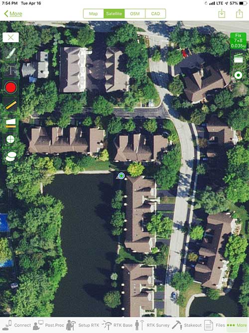
iOS aerial viewer. (Screenshot: Tim Burch)
The 1980s and 1990s brought significant changes to surveying with the advancing technology of electronic computing and measuring. The introduction of robotic total stations, various methods of GNSS, and even leveling took advantage of significant computer power and measuring processes, and the data collector stayed in lockstep with the advancing instrumentation. Almost every equipment manufacturer developed their own proprietary data collector and software system because of the unique design and programming of their systems.
In the 2000s and later, third-party manufacturers began producing data collectors with advanced computing power and the ability to connect to varying brands of equipment. Most of the programming for these collectors are still proprietary in nature to this day.
Also during the 2000s, a new wave in mobile communications was taking place. Cellular phone and data signals were now being used to transmit an abundance of information between users.
The rapid development of handheld communication devices has led to the meteoric rise of two specific mobile operating systems: one by a radical startup that concentrated on dominating the search engine market, and the other by an avant garde computer company looking to expand its unique customer base.
By the end of the decade, the world had been introduced to the Android operating system by Google, and the iOS operating system by Apple. The combined market share for the two operating systems at press time was just under 98 percent of all mobile devices worldwide.
Trending Away from Proprietary Data Collectors
Android Point Info: Confirmation of collected data, including equipment and base station. (Screenshot: Tim Burch)
Because data collection by surveyors and mappers have traditionally been performed on proprietary systems designed and produced by equipment manufacturers for use with only their instruments, these collectors, while very powerful and robust, are costly for the equipment manufacturers to produce because of the limited market of surveyors and mappers.
Many suppliers, before the introduction of the iPhone and Android operating systems, attempted to adapt their data-collection platforms to wider recognized mobile operating systems (for example, Windows CE/Pocket PC/Mobile) on a bevy of mobile devices (HP/iPAQ, Sony Eriksson, HTC) with little success. Various versions of Windows are still being used today by GNSS equipment manufacturers’ proprietary data collectors, including Trimble, Hemisphere GNSS, Topcon and CHC Navigation.
However, the field of operating environments has become more crowded as technology continues to advance. The proliferation of Windows-based data collectors are now on the decline.
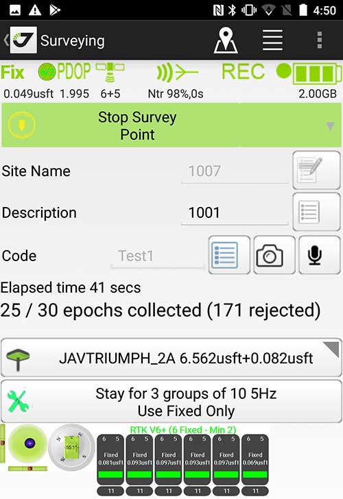
Survey Point: Status of survey data collection and GNSS engine signal reception. (Screenshot: Tim Burch)
Enter Android and iOS. Driving the decline of the previously popular Windows mobile platform is the rapid adoption of the iOS and Android operating systems. These two environments have also led to a substantial number of devices and applications for users.
Part of the reason for the speedy acceptance of the devices and operating systems has been the ease of programming. It is estimated that each operating system has more than two million applications in their respective online stores, with more being introduced daily.
Because of the proliferation of smartphones, nearly everyone is familiar with the look, feel and operation of touchscreen devices and their various applications. This familiarity is driving a new trend in data collection: the concept of “bring your own device” (otherwise known in IT security circles as “BYOD”). BYOD is being introduced by several surveying and mapping equipment manufacturers as an alternative to their proprietary data-collection devices.
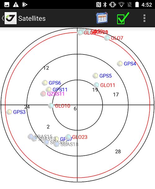
Sky Plot: Where the ‘birds’ are in the sky. (Screenshot: Tim Burch)
These manufacturers are pairing iOS and Android developers with their hardware and firmware specialists to create a user-friendly interface that will function on most of the most popular handheld devices on the market today. From Apple iPhones and iPads to Samsung Galaxy phones and tablets, these applications give the surveyor the best of two worlds — sophisticated data-collection capability on a well-known and reliable mobile operating system platform.
The Android platform is becoming especially popular in the handheld mapping market segment. Current users of this environment include Hemisphere GNSS, CHC Navigation, Tersus GNSS and Trimble.
The iOS applications, while not quite as prevalent as Android, are being embraced by several significant GNSS manufacturers, including JAVAD GNSS and Eos Positioning Systems.
These companies are creating iOS and Android apps that embrace the BYOD market, providing their users with affordability and creating a comfort level simply because of the familiarity of the device and its environment.
How Good Is It?
iOS Position. Status of survey data collection and GNSS engine signal reception. (Screenshot: Tim Burch)
For the surveyor to be satisfied with the operation, the collection process must be efficient, cost-effective and easy to use. For this explanation of key items within a well-rounded data-collection application, we are using the JAVAD Mobile Tools (now J-Mobile) application built specifically for the Android and iOS operating systems.
The Android system (Version 7.0) was installed on a rugged CAT S41 cellphone made Bullitt Group from the United Kingdom, while the iOS app was used on the author’s iPad Air 2 running Version 12.2. Both apps were utilized in conjunction with the JAVAD Triumph-2 GNSS receiver.
After putting both versions through trial testing and checking against values on known monuments, here is the results of our findings:
Receiver Setup. Visual reference for leveling and direction of GNSS receiver. (Screenshot: Tim Burch)
Data Organization. Easy to comprehend and flexible for most naming conventions.
Corrections and Sources. Easily connects to base receiver and radio or available NTRIP correction service for real-time network (RTN) capability.
Sky Plot. Because the Triumph-2 is equipped to receive most of the available satellites in service, the Sky Plot feature is beneficial to the user for assessing potential interference.
File Management, Import and Export. Covers the typical file management and transfer functions used by the surveyor.
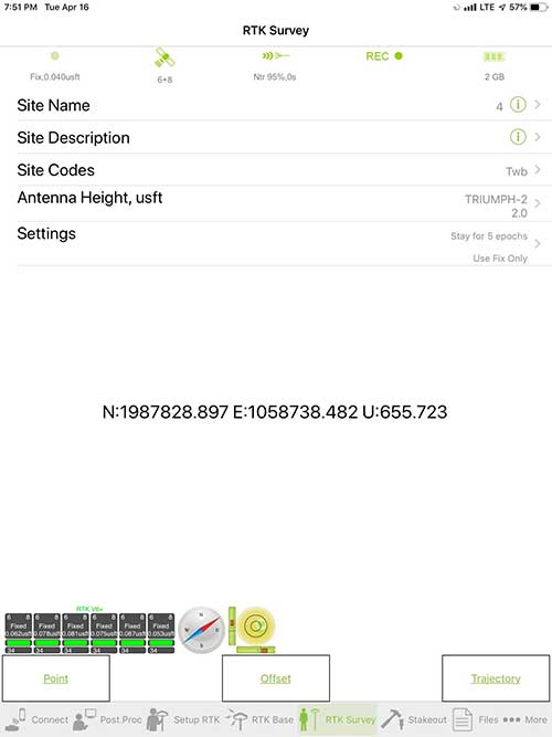
RTK Survey Operations. Robust telemetry keeps the users informed of specific satellite data and correction status.
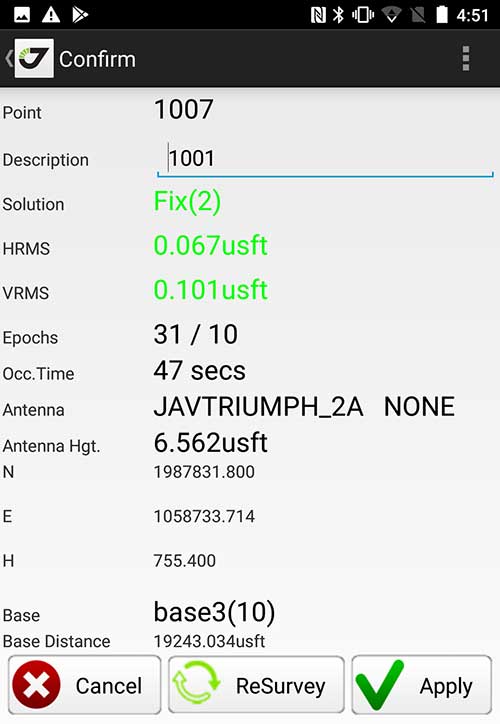
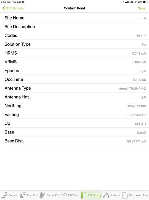
Point Confirmation. Survey point information with metadata and equipment listing. (Screenshot: Tim Burch)
Coordinate Systems. All standard coordinate systems are included with features to allow the user to customize their own systems.
Localization. Creation of a local coordinate system is a simple routine, providing strong quality checks for data integrity.
Lift and Tilt. This feature provides the user with a useful procedure to end data collection without the need to press a button. This feature significantly increases the user’s productivity.
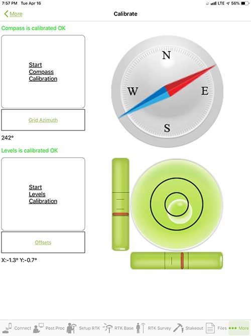
Compass and Level Calibration. With the Triumph-2 having an internal compass and level system, status of the receiver is graphically displayed to help the user keep a close watch on the accuracy of the survey point.
Survey Points and Linework. Most point naming systems and line-coding procedures are easily adapted. Total Station Point Transfer. The creation of control point files for transfer to total stations is simple and easy to use.
Stakeout. Graphical status screens provide the user with simple plotting capability of the desired stakeout point to increase efficiency and accuracy.
These apps are good at providing the surveyor with a solid tool for data collection and staking capability. They are especially good when paired with a real-time kinematic
(RTK) base station or NTRIP correction service.
But what happens when cell service is not readily available, or there are no published monument coordinates to establish site control? These apps have the surveyor covered for that situation as well.
Post-Processing (OPUS and DPOS)
Today’s surveyor works in an environment where geographic-based data is a key component to the services they render to their clients. While most of the world’s developed nations have access to cellular networks in which most GNSS receivers can communicate with an RTN providing corrective solutions, the places where this is not possible relies on other means of data correction.
In the U.S. we rely on OPUS (Online Post-Processing User System) to provide that service. But, as good as it is, it has limitations. Currently, it only utilizes GPS satellite data from the U.S. Department of Defense and is subject to sporadic government shutdowns.
Other services, from both public and private sources, are in place around the world to provide a service similar to OPUS. These include, but are not limited to:
AUSPOS. Geoscience Australia (free)
APPS. Jet Propulsion Laboratory at California Institute of Technology (free)
CSRS-PPP. Natural Resources Canada (free)
GAPS. University of New Brunswick (free)
magicGNSS. GMV (free)
Centerpoint RTX Post Processing. Trimble (free)
JAVAD Data Processing Service (DPOS). JAVAD (free, processes any JAVAD GNSS jps file)
These correction services utilize other satellite constellations (GLONASS, Galileo, BeiDou and QZSS) for their solutions and can provide additional coverage, depending on the location of the user. Because of these services, geographic-based data is at the fingertips of surveyors worldwide.
JAVAD’s DPOS system is has the ability to collect static survey data and send it to the proprietary service for establishing new coordinate values for base-station use. This process is a function of the app and can be completed in a few short steps.
Once the base station values are calculated, the surveyor can make use of this information for establishing a base station for correction broadcasting.
Do You Need a Base Station?
The establishment of RTNs has greatly enhanced surveying capability as cellular service has increased in coverage and speed. However, there are still instances and locales that do not allow for the reliable use of cell signals to provide those corrections accurately.
Various manufacturers’ tests have proven the accuracy of using an RTN subscription versus the traditional GNSS base and rover RTK setup. But cell-signal strength can be an Achilles heel, crippling those who choose not to set up a base station.
The UHF radio, even in its reduced power state from regulatory changes, is still more powerful and reliable than most cell services. 5G technology and coverage is anticipated to revolutionize cellular service, but it has yet to be realized.
Adaptation of the Industry
Other GNSS manufacturers (including NovAtel, Navcom, ComNav, Unicore, Emcore, Suzhou, TeleOrbit and Geneq) are producing receivers that can be adapted to a variety of existing data collectors and connect to iOS/Android mobile devices through various software developers.
The future of communications remains the smartphone or tablet device, with foldable units expected to be the next big thing.
As processors get more powerful, as chip memory becomes more abundant, and as more satellite constellations orbit in our sky, surveyors and their data collectors will continue to evolve. The future remains bright for technology and the surveyor has a front-row seat.
TIM BURCH is GPS World’s contributing editor for Survey. A professional land surveyor with more than 30 years of experience, he is director of surveying at SPACECO Inc. in the Chicago area. For several years he has been secretary and was recently named vice-president of the Board of Directors of the National Society of Professional Surveyors. He writes a bi-monthly column in the Survey Scene e-newsletter. Subscribe free at env-gpsworld-integration.kinsta.cloud/subscribe.
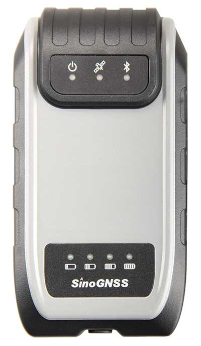
Receiver, Software Ready for Mobile
Photo: ComNav
ComNav receivers offer multiple data-collection device choices via Bluetooth connection, as well as an Android app.
For instance, the G200 provides centimeter-accuracy positioning to any connected mobile devices for RTK field surveying. It is able to delivery robust survey workflows with the SinoGNSS Android-based Survey Master, so that surveyors can collect quality high-accuracy positions no matter what mobile device they are using.
The G200 is a rugged, compact, wearable GNSS receiver. Combined with the high-performance SinoGNSS OEM board tracking GPS L1/L2, BeiDou B1/B2, GLONASS L1/L2, Galileo and QZSS, the G200 enables reliable high-precision GNSS performance for land survey tasks anywhere in the world.
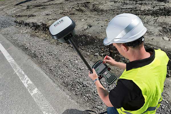
TerraStar Gives Assist to RTK
Photo: Leica Geosystems
NovAtel offers several levels of corrections via its TerraStar service. For surveying applications, the RTK Assist service provides correction data to bridge surveyors through any real-time kinematic (RTK) correction outages. TerraStar services work on NovAtel’s OEM6 and OEM7 receivers..
RTK Assist, available on OEM6/OEM7 receivers, provides 20 minutes of RTK assistance, enabling surveyors to maintain centimeter-level accuracy. A higher service level, RTK Assist Pro, is available on OEM7 receivers. It provides unlimited RTK assistance with stand-alone centimeter-level positioning when RTK is not available.
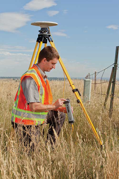
Trimble Offers Web-Based Post-Processing
Photo: Trimble
Trimble’s CenterPoint RTX Post-Processing Service is a free, web-based solution that provides rigorous processing of GNSS data for users around the globe.
Powered by advanced algorithms for processing static observations, CenterPoint RTX Post-Processing supports data including GPS, GLONASS, Galileo, BeiDou and QZSS. With the service, users can upload GNSS data using Trimble formats or industry-standard RINEX 2 and RINEX 3. The service supports all dual-frequency GNSS receivers and more than 400 different antennas.
The post-processing service computes single-station static observation sessions ranging in length from 10 minutes up to 24 hours, with longer observation sessions recommended to produce the highest accuracy. Using data from the global RTX tracking network, the CenterPoint RTX Post-Processing service computes the position of the observed point with centimeter accuracy.
Results are delivered via email in ITRF coordinates at the current epoch and can be transformed to a fixed epoch by use of a standard tectonic-plate model.
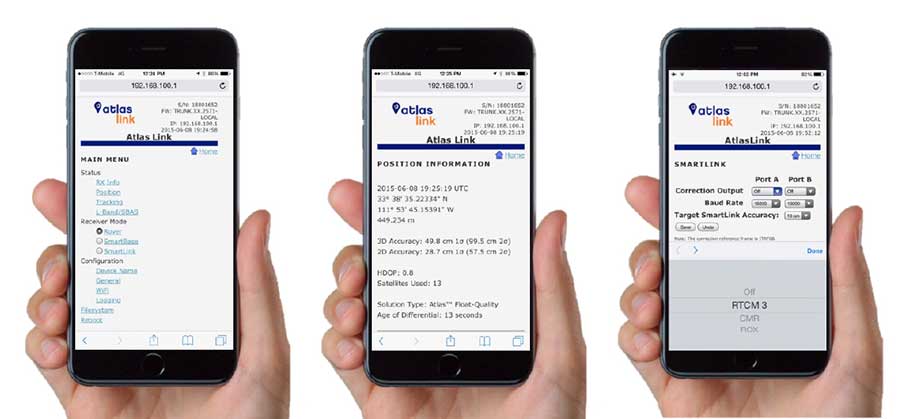
Atlas Corrections Ready for BYOD
The Atlas GNSS global correction service, offered by Hemisphere GNSS, provides correction data for GPS, GLONASS, BeiDou and Galileo constellations. Its global L-band corrections allow for accuracies ranging from sub-meter to sub-decimeter levels. The network has more than 200 reference stations worldwide and covers virtually the entire globe.
Examples of how the AtlasLink webUI looks on a smartphone. (Image: Hemisphere GNSS)
The Atlas platform was conceived to enable as many people as possible to have access to the correction service technology, either as an end-user or as part of their business. Several features are designed to enable customers who use non-Hemisphere positioning systems to have access to Atlas.
For instance, Hemisphere’s SmartLink technology allows an AtlasLink GNSS smart antenna to be used as an Atlas signal extension for any GNSS system compliant with open communication standards.
Hemisphere’s GNSS smart antennas including AtlasLink, A326, C321+ and S321+ offer a user-friendly web user interface (WebUI) that can be used to configure, monitor and manage the receiver from virtually any modern computing device, including computers, phones and tablets.
Eos Positioning Systems has donated an Arrow Gold GNSS receiver to Haiti Outreach, a 21-year-old nonprofit organization dedicated to helping Haiti become a developed country.
Haiti Outreach collaborates with individual Haitian communities to create and maintain access to potable water through community outreach, well digging and distribution-network development.
The Arrow Gold GNSS receiver helps Haiti Outreach build and improve potable water distribution networks by providing accurate subfoot elevations required for hydraulic modeling simulations, the company said. It uses Atlas satellite-based corrections to provide real-time decimeter (three to five centimeters) location throughout the country.
“Water is life, and making this basic necessity available to every person is at the foundation of Haiti Outreach’s work,” said Eos Positioning Systems CTO Jean-Yves Lauture. “I believe strongly in Haiti Outreach’s long-term vision to empower Haitian communities through development, education and cooperation.”
Haiti Outreach first began in 1997, with a mission to bring clean water to more people in Haiti and encourage them to take on the responsibility of maintenance and sustainability. In 2005, the organization shifted its focus toward greater community outreach and support, developing a program much more effective at producing the desired long-term outcome. Its community-led initiatives are heavily planned and prioritized, thanks to comprehensive field data collection and advanced geospatial analysis, Eos said.
“In most of these communities, there has only ever been a short-term vision, because the need has always been urgent,” Lauture said. “Haiti Outreach is changing that mentality. They are providing a development plan for now and the future. This is a slow process but is already proving successful. It is a true privilege to be able to support such noble efforts.”
Hemisphere GNSS has released the new single-frequency, multi-GNSS Vector V123 and V133 all-in-one smart antennas with integrated Atlas L-band designed for professional and commercial marine applications.
The company made the announcement at the Oceanology International conference being held this week in London, U.K.
Powered by Hemisphere’s Crescent Vector technology, the new V123 and V133 are multi-GNSS compass systems using GPS, GLONASS, BeiDou, Galileo and QZSS for simultaneous satellite tracking to offer heading, position, heave, pitch and roll. Both antennas support NMEA 0183 and NMEA 2000.
The V123 and V133 thrive in radar/ARPA, AIS, ECDIS, side-scan survey, multi- and single-beam surveys, dredging and general navigation applications.
The V123 and V133 rugged smart antennas combine Hemisphere’s recently announced Crescent Vector H220 OEM board and two superior multipath- and noise-rejecting antennas (spaced 50 centimeters apart) in a single enclosure.
The smart antennas require only a single power/data cable connection for fast and reliable installations, even in the presence of strong radio transmissions. Both Vector models provide 0.3-degree heading accuracy and sub-meter DGPS accuracy, as well as optional 0.5-meter Atlas L-band accuracy.
The V133 includes all the features of the V123 and adds the capability of receiving differentially corrected data from land-based beacon stations. Ease of installation and no maintenance or servicing enhances the simplicity of these new Vector models.
“The Vector V123 and V133 GNSS compasses represent significant enhancements to our industry leading models they replace, providing even greater performance, improved robustness and excellent value,” said Miles Ware, director of marketing at Hemisphere GNSS. “Users now have an even higher performing all-in-one Vector for their commercial and professional needs with the addition of BeiDou, Galileo, and QZSS as well as Atlas L-band corrections.”
Hemisphere GNSS has debuted the scalable A222 GNSS Smart Antenna. Purpose-built for harsh outdoor applications, the A222 is designed for both agriculture and basic indicate systems markets, as well as other markets requiring flexible positioning.
The smart antenna has the flexibility to scale and grow as business expands and can be configured from L1-only to multi-GNSS, multi-frequency and real-time kinematic (RTK) capable. The A222 adds a system component so that tractor and farm equipment manufacturers can deliver their own guidance and control solutions to their customers.
Designed to excel in challenging environments, the A222 uses Hemisphere’s Athena RTK engine and is Atlas L-band capable. It is easy to mount and customizable. Its dual-serial, CAN and pulse output options are compatible with almost any industry-standard interface.
As the A222 is Atlas-capable, it has the ability to use the new Atlas AutoSeed technology. Atlas AutoSeed allows users to suspend Atlas use for any period, and upon returning to their last location, AutoSeed rapidly re-converges to a high-accuracy converged position.
A222 comes pre-configured with Atlas Basic activated.
Hemisphere GNSS debuted the A222 at Agritechnica 2017, held Nov. 12-18 in Hannover, Germany. Hemisphere is exhibiting at Hall 15, Booth E10.
Hemisphere GNSS released a series of major enhancements to its Atlas GNSS Global Correction Service, including Atlas Basic, Atlas AutoSeed and the addition of global ionospheric modeling to the system.
The company made the announcement at Agritechnica 2017, Nov. 12-18 in Hanover, Germany, where it exhibited in hall 15, booth E10.
Atlas is a flexible and scalable GNSS-based global L-band correction service, providing robust performance and correction data for GPS, GLONASS and BeiDou, the company said. Delivering its correction signals via L-band satellites at accuracies ranging from meter to sub-decimeter levels, Atlas also leverages 200 reference stations worldwide, providing coverage to virtually the entire globe.
Atlas Basic. Hemisphere is now offering Atlas Basic. Atlas Basic provides users of both single- and multi-frequency Atlas-capable hardware the ability to achieve SBAS-equivalent performance anywhere in the world where the Atlas correction service is available.
Atlas Basic offers accuracy of 30 to 50 centimeters (cm): 30 cm is pass-to-pass 95 percent based on 15-minutes convergence time, and 50 cm is absolute 95 percent. Atlas Basic also offers instantaneous sub-meter accuracy, allowing for Differential GPS (DGPS) level accuracy.
Hemisphere is offering Atlas Basic as an activation on all Atlas-capable single- and multi-frequency Hemisphere products purchased before Feb. 1, 2018. Correction service users will no longer need subscriptions for Atlas Basic service levels at 50-cm (95 percent) accuracies.
“Having the ability to easily scale your correction service levels based on specific use cases is essential to our customers and OEM partners,” said Miles Ware, director of marketing at Hemisphere GNSS. “With the addition of Atlas Basic, we are making it easier for anyone with an Atlas-capable single- or multi-frequency, multi-GNSS receiver to achieve sub-meter, SBAS-equivalent positioning accuracy virtually anywhere on earth.”
Global ionospheric modeling. Also included in the enhanced Atlas system is the addition of global ionospheric modeling. Using real-time ionospheric data, Atlas adjusts its corrections accordingly, providing instantaneous convergence for sub-meter accuracy.
AutoSeed. Atlas’ new AutoSeed technology allows users to suspend Atlas use for any period, and upon returning to their last location, AutoSeed rapidly re-converges to a high-accuracy converged position.
* Based on 15-minutes convergence time. Also depends on multipath environment, number of satellites in view, satellite geometry and ionospheric activity.
Atlas is available on all Hemisphere Atlas-capable single- and multi-frequency, multi-GNSS hardware and complements third-party GNSS receivers by allowing them to use Atlas corrections with Hemisphere’s SmartLink and BaseLink capabilities.
When using multi-frequency hardware, Atlas corrects more satellites than ever before, to create faster convergence times, and is robust and reliable in canopy or foliage covered areas.
With both single- and multi-frequency hardware, Atlas achieves instant global sub-meter positioning accuracy, comparable to and typically more robust than SBAS, since Atlas corrections contain data from multiple available constellations, the company said.
Carlson Software is now offering Atlas GNSS global correction service in the latest release of its data-collection software SurvCE.
Using approximately 200 reference stations worldwide, Atlas produces its correction signals via L-Band satellites distributing coverage from 75° N to 75° S, ensuring Earth’s landmass is covered. Such ability makes it the most flexible service on the market to date, Carlson Software said.
“Atlas equals or excels beyond the performance standards of other services and interfaces seamlessly with Carlson SurvCE to boot,” said Karl Nicholas, special projects director at Carlson Software.
Atlas supports multiple RTK-capable GNSS receivers including the current Carlson BRx6. Through Carlson SurvCE’s library of compatible drivers, any third-party GNSS receiver using the Athena engine can also use Atlas.
Capabilities
Positioning Accuracy: Atlas provides positioning accuracies down to 2 cm RMS in certain applications
Positioning Sustainability: Cutting-edge position quality maintenance in the absence of correction signals
Convergence Time: Industry-leading convergence times of 10 – 40 minutes
Scalable Service Levels
H100: 100 cm 95 percent (50 cm RMS)
H30: 30 cm 95 percent (15 cm RMS)
H10: 8 cm 95 percent (4 cm RMS)
Subscriptions to Atlas can be added to the Carlson BRx6 or other supported GNSS receiver when using SurvCE version 5.06 or later through a certified Carlson dealer or at carlsonsw.com/atlas.
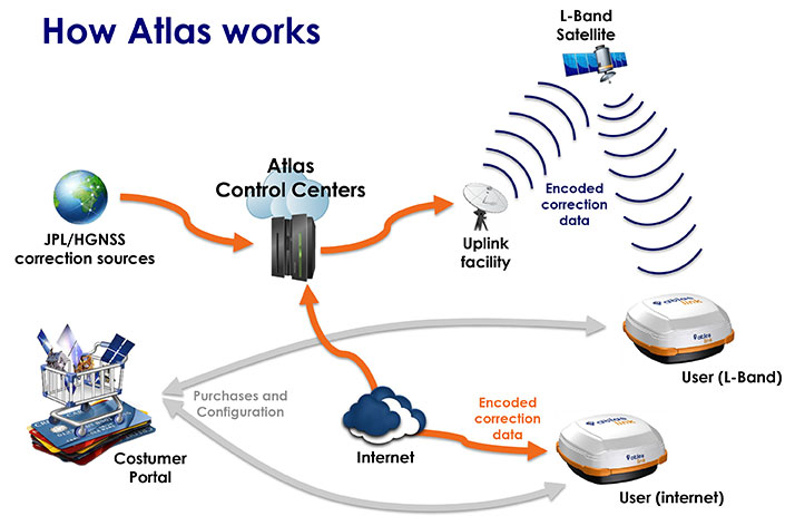
Rodrigo Leandro of Hemsphere GNSS talks about the company’s new Atlas correction service while at INTERGEO 2015, which was held Sept. 15-17 in Stuttgart, Germany.
Atlas Global Correction Services’ signals via L-Band satellites or over the Internet at accuracies ranging from meter to sub-decimeter levels.
Hemisphere GNSS will be showcasing its new Atlas GNSS global correction service at the INTERGEO 2015 Conference and Trade Fair Fair in Stuttgart, Germany, held Sept. 15-17. Hemisphere GNSS will exhibit at Booth E6.093.
The Atlas correction service offers innovative and accessible correction service options, providing performance in demanding applications and environments, Hemisphere said. Available through various subscription and bundle options, Atlas is a flexible correction service with correction data delivered via L-band satellites or over the Internet at accuracy levels ranging from meter-level to sub decimeter-level.
The Atlas platform offers endless possibilities through hardware, software, and branding integration into various products and customized solutions, the company said. Several new Hemisphere products with Atlas support targeted for specific applications will be on display at INTERGEO, including Hemisphere’s latest AtlasLink GNSS smart antenna. Other Atlas capable products, including R330, V320 and VS330 will also be showcased.
AtlasLink, the multi-GNSS, multi-frequency smart antenna, is preconfigured to receive corrections from the new Atlas platform. The bundled AtlasLink solution provides users worldwide with the easiest way to utilize Atlas corrections — either directly from AtlasLink, or on their existing receivers via innovative new technologies built into AtlasLink.
“AtlasLink is a game changer” declared Chuck Joseph, Hemisphere GNSS CEO and president. “On its own it is a fantastic smart antenna with industry-leading RTK, connectivity and management capabilities. Further, when you add in the ability to deliver Atlas GNSS corrections to equipment you already own, from any vendor, you have a real powerhouse that will allow you to get much more from your existing GNSS equipment.”
Live demonstrations of Atlas GNSS global correction service and AtlasLink GNSS smart antenna will be given daily. Contact Hemisphere GNSS to schedule a time or visit booth E6.093 during the show.
Eos Positioning’s Arrow 200 Bluetooth receiver now supports Hemisphere’s Atlas correction service,
The Arrow 200 Bluetooth GNSS receiver by Eos Positioning Systems now supports the new Atlas H10 GNSS correction service. Using the H10 service, the Arrow 200 GNSS receiver is able to achieve 8-cm accuracy, in real-time, virtually anywhere in the world, the company said. The H10 corrections are delivered by geostationary satellite or via Internet connection.
The Hemisphere GNSS Atlas correction service, announced in June, is a real-time correction service that meets or exceeds existing correction services. It has three service levels, with H10 having the highest accuracy.
“Eos is proud to introduce the first GNSS receiver that supports the H10 service,” said Chief Technology Officer Jean-Yves Lauture. “It will allow our customers in every country in the world to have access to sub-decimeter real-time accuracy on all mobile platforms, including iOS, Android and Windows devices.”
The H10 correction service and the Arrow 200 support all active constellations including GPS, GLONASS, Galileo, BeiDou and QZSS, giving the user ultra-fast convergence time to real-time decimeter accuracy, Eos Positioning said.
The Arrow 200 employs long-range (1 km) universal Bluetooth connectivity so the user can interface to any brand of smartphone or tablet, whether it’s iOS, Android or Windows-based. The Arrow 200 has been optimized to run all day on battery power. The battery pack is field-replaceable and rechargeable separately. All Arrow receivers have been designed to meet IP-67 specifications for immersion in water and are completely dust-proof so they will survive in the harshest environments.
The Arrow 200 GNSS receiver with Atlas H-10 service is targeted at high-accuracy applications like GIS, environmental, agriculture, electric/gas/water utilities, surveying, machine control, and federal, state and local government.