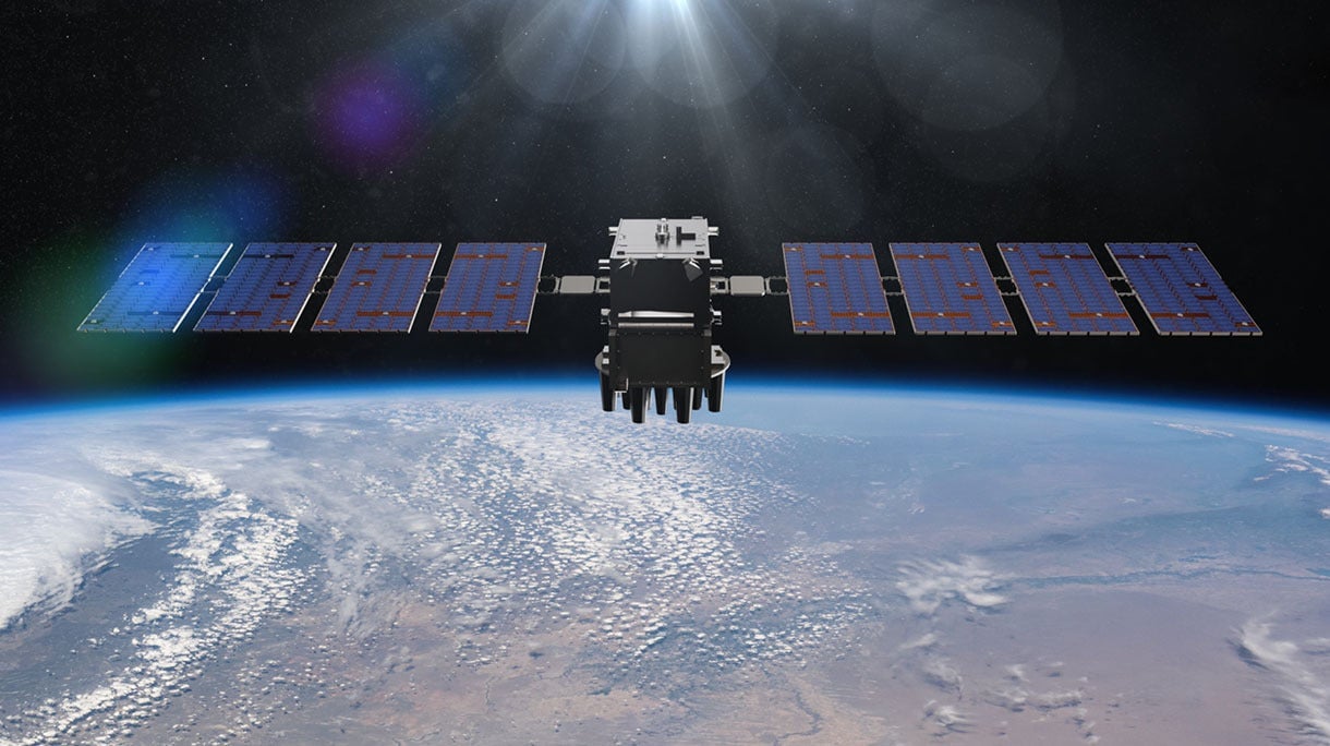
L3Harris has demonstrated a positioning, navigation and timing (PNT) solution for the U.S. Space Force’s Space Systems Command that is adaptable across platforms, fully reprogrammable on orbit and scalable to support more signals and increased power as PNT threats evolve. According to L3Harris, the solution is designed to provide the Space Force with the flexibility to deploy smaller, multi-launch-capable satellites, thereby strengthening or diversifying its satellite constellation.
During a two-day design concept review, L3Harris presented a resilient-GPS (R-GPS) prototype that exceeded current requirements, highlighting its potential to accelerate the Space Force’s roadmap for a stronger, more adaptable PNT infrastructure. Using the Navigation Technology Satellite-3 reprogrammable payload and NSA-certified cryptography, the company simulated the operation of an R-GPS satellite transmitting navigation signals. These signals were successfully acquired and tracked by monitoring stations, military receivers and commercial equipment, demonstrating that R-GPS technology can be seamlessly integrated into the existing GPS framework.
“Our team transmitted, tested and validated a core set of R-GPS signals across the entire enterprise to demonstrate a fully reprogrammable, resilient PNT solution for the Department of Defense,” said Ed Zoiss, president of Space and Airborne Systems at L3Harris. “We leveraged best-in-class commercial technology and the government’s investment in NTS-3 PNT technologies.”
L3Harris followed a “prototyping with purpose” approach that showcased maturity far beyond a traditional Preliminary Design Review, resulting in a low-risk, achievable plan for the future development phases of the R-GPS program. The L3Harris R-GPS design includes capabilities aligned to future Lite Evolving Augmented Proliferation, providing an opportunity for roadmap acceleration and reduction in lifecycle costs.
“Our approach supports satellite design verification, proves compatibility with the Control Segment and user equipment, and enables early integration opportunities,” Zoiss said. “After more than five decades in the field, we understand the challenges in aligning the Space, Control and User segments of the GPS enterprise, so we used a holistic, unified approach.”
The Design Concept Review demonstrated how the L3Harris R-GPS satellite can minimize impact on existing control systems while maintaining backward compatibility with current and future user equipment. In 2024, L3Harris was selected to design concepts for Phase 0 of the R-GPS program through the Space Enterprise Consortium, which the National Security Technology Accelerator manages. The agile R-GPS satellite program aims to reduce costs by launching eight smaller, more advanced space vehicles simultaneously, allowing the United States to quickly modernize GPS.
Sierra Space, a commercial space and defense technology company, has successfully completed another demonstration of its resilient GPS (R-GPS) technology for the U.S. Space Force. This achievement marks the third major milestone for the program, which is designed to enhance the resilience of GPS infrastructure against threats such as jamming and spoofing. The recent demonstration included early integration of R-GPS satellite technology using FlatSat flight software and hardware subsystem testing, as well as successful communication with ground software systems.
The R-GPS effort is part of a broader initiative by the U.S. Space Force’s Space Systems Command to develop smaller, more cost-effective GPS satellites. Sierra Space was awarded a Quick Start contract in September 2024 to produce design concepts for these satellites, aiming to rapidly bring advanced technology to the national security space sector. The company’s progress comes just six months after the program’s inception, highlighting its ability to accelerate technology development in response to evolving defense needs.
GPS technology is integral to both civilian life and military operations, supporting applications that range from smartphone navigation to critical defense activities. As adversarial threats become more sophisticated, the need for resilient GPS systems has grown. The R-GPS program addresses this by planning to augment the existing GPS architecture with a network of smaller satellites, which would provide additional layers of security and rapid deployment capabilities.
The latest testing milestone demonstrated the flow of commands and telemetry between Sierra Space’s ground software and a ground stations service provider, establishing that the technology can operate effectively between orbit and ground-based facilities. The FlatSat testing format, where satellite components are evaluated while laid out flat, allowed for early integration of flight software and hardware subsystems.
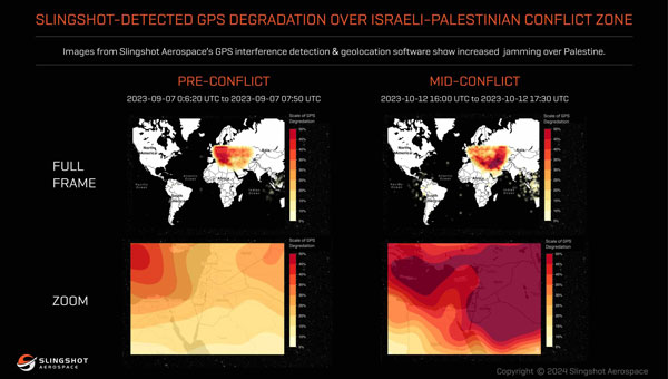
The U.S. Space Force’s Space Systems Command (SSC) has awarded a $1.9 million contract to Slingshot Aerospace to enhance its GPS jamming and spoofing detection capabilities. This contract, Positioning, Navigation and Timing – Secure Electronic Navigation Threat Intelligence and Location (PNT-SENTINEL), aims to improve the company’s existing technology by incorporating advanced artificial intelligence and predictive analytics.
The PNT-SENTINEL program builds upon Slingshot’s previous work under the Data Exploitation and Enhanced Processing (DEEP) contract, awarded in October 2021. The technology developed through DEEP currently assists the U.S. Space Force in detecting GPS jamming and ground-based interference sources related to ongoing conflicts, potential future conflict zones and counterterrorism efforts.
GPS spoofing and jamming pose significant threats to both military operations and civilian infrastructure. Such interference can impact a wide range of operations, including satellite systems, ground and air operations and critical services such as commercial airline operations and vehicle navigation. The global reliance on GNSS has increased the importance of protecting these signals from interference.
Slingshot’s technology utilizes a mesh network of thousands of satellites to create a near-real-time picture of GPS jamming occurrences worldwide. This space-based approach offers a more comprehensive view of global jamming conditions compared to traditional ground-based detection systems.
As part of the contract, Slingshot will integrate its AI model, Agatha, into the PNT-SENTINEL system. This integration aims to enhance the technology’s ability to detect and differentiate between unintentional interference and deliberate jamming or spoofing attempts. The improved system will also implement pattern recognition algorithms to identify active jamming events and predict how situations may evolve.
The contract also includes provisions for expanding the system’s capabilities to monitor interference across multiple GNSS sources, not just GPS. This multi-GNSS processing will allow for a more complete, real-time view of jamming activities by incorporating data from allied nations’ spacecraft.
The PNT-SENTINEL system is designed to be interoperable with existing military systems, enabling near-real-time information dissemination to support rapid decision-making in national security operations. These enhancements aim to provide warfighters with a strategic advantage in GPS-contested environments.
L3Harris Technologies has received a contract from the U.S. Space Force’s Space Systems Command to develop design concepts for Phase 0 of the Resilient Global Positioning System (R-GPS) program.
This initiative aims to enhance the existing GPS constellation by integrating cost-effective small satellites, providing increased resilience for both military and civilian users. The R-GPS program seeks to augment the current 31-satellite GPS constellation with up to eight additional satellites. The new satellites are designed to counter various threats, including jamming, spoofing and more, ensuring uninterrupted positioning, navigation and timing (PNT) services.
L3Harris has provided navigation technology for all U.S. GPS satellites launched to date. The company has also contributed to the development of control systems and monitoring receivers and user equipment for GPS. This experience serves as the basis for their proposed R-GPS solution.
L3Harris is leveraging its investments in transformational PNT technology to meet the Space Force’s evolving requirements by using commercial form factors and interfaces to create a modular, scalable solution, the company said. Additionally, L3Harris is collaborating with the Space Force as the prime contractor for the experimental Navigation Technology Satellite-3 program, which focuses on developing innovative technologies and accelerating development timelines.
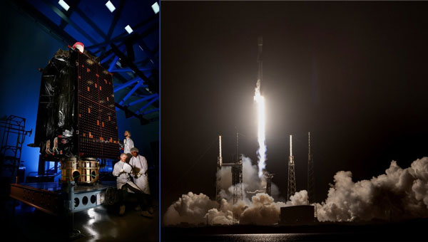
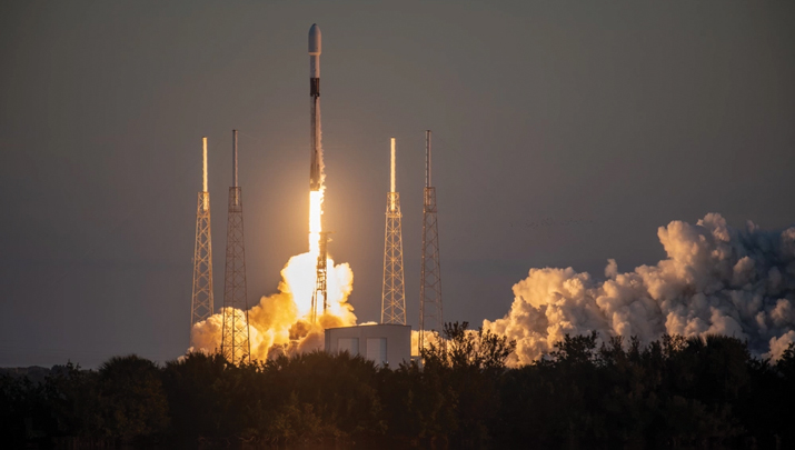
Following weather delays, the U.S. Space Force’s Space Systems Command (SSC) and Space Operations Command expedited the Rapid Response Trailblazer launch schedule to fulfill a specific warfighter requirement. On Dec. 16, 2024, SpaceX’s Falcon 9 rocket launched the GPS III SV-07 satellite from Space Launch Complex 40 at Cape Canaveral Space Force Station, Florida.
For the mission, multiple Space Force organizations collaborated to retrieve an existing GPS III satellite from storage, expedite integration and launch vehicle preparation, which was quickly processed for launch. The success of the launch proved a two-fold concept of operations. SSC’s Assured Access to Space showcased its agility in partnering with industry to meet evolving national needs, completing a National Security Space class launch in less than five months.
This marks the first Space Operations Command mission led by Mission Delta 31 for a Space Vehicle launch, and it demonstrated exceptional flexibility by reducing the typical six-month pre-launch processing timeline to approximately three months, Space Operations Command said. This effort involved close coordination with Lockheed Martin in Colorado to rapidly prepare SV-07 for launch.
The GPS III SV-07 satellite joins a robust constellation comprising 31 active vehicles, seven in reserve status and three completed GPS III vehicles awaiting launch. Equipped with M-Code technology, these satellites offer improved anti-jamming and anti-spoofing capabilities, enhancing secure access to military GPS signals for U.S. and allied forces.
The U.S. Space Force’s Space Systems Command (SSC) has awarded Raytheon a $196.7 million contract extension for the GPS Next Generation Operational Control System (OCX) program — despite being years behind schedule. This latest award brings the total OCX contract value to nearly $4.5 billion since its inception in 2010. However, according to the U.S. Government Accountability Office (GAO), the total amount is approaching $8 billion.
The OCX program, designed to enhance GPS infrastructure, has faced significant setbacks. It is currently about seven years behind the original schedule, with the GAO reporting that the system of 17 ground stations was not ready by its October 2024 deadline. Further testing is required for the system to be operational by December 2025.
Despite these challenges, OCX remains critical for modernizing GPS capabilities. The system will enable full M-Code capabilities, providing jamming-resistant GPS signals for military operations in contested environments. OCX is also designed to improve cybersecurity for both military and civilian applications significantly. Once operational, OCX will command all modernized and legacy GPS satellites, managing all civil and military navigation signals.
The program has faced scrutiny due to its delays and cost overruns. The GAO has flagged the program’s delays as a risk to the GPS enterprise, while lawmakers have expressed frustration over the delays and budget increases. Despite this, the Space Force continues investing in the program to enhance GPS capabilities for military and civilian users. OCX is expected to provide improved accuracy, availability and resistance to jamming compared to the previous ground control segment. The system will also support the launch and operation of GPS III satellites.
The Pentagon’s first batch of new and more capable GPS satellites, part of the GPS IIIF program, is facing significant delays. The first batch is eight to eleven months behind schedule, which the U.S. Space Force attributed to manufacturing difficulties encountered by contractor Lockheed Martin, particularly with complex components necessary for the satellites’ operation. Originally expected to be available for launch in April 2026, the first satellite’s delivery has now been pushed to November 2026.
The GPS IIIF program is a $9.2 billion initiative aimed at deploying up to 22 advanced satellites. The first ten satellites in this series are designed to enhance the GPS system with improved accuracy and jamming-resistant signals. These satellites will serve both critical defense applications, such as guiding smart bombs, and civilian uses, such as turn-by-turn navigation.
The new F-model satellites promise increased navigation accuracy, a signal compatible with similar European satellites, greater resistance to cyberattacks and jamming and civilian search-and-rescue capabilities to detect and locate emergency beacons.
“For the average driver using GPS navigation,” the new satellites will provide “enhanced route planning and navigation, reducing travel time and improving fuel efficiency” and a “consistent GPS service even in urban canyons and areas with tall buildings,” according to the Space Systems Command.
According to the US Space Force, The primary obstacle appears to be the production of the Mission Data Unit, a crucial new component for improved navigation. Bloomberg reported that the subcontractor, L3Harris Technologies, manufactures this unit and is experiencing technical issues.
Despite these setbacks, Lockheed Martin is reportedly on track to meet the contracted delivery dates, even if they miss the Space Force’s preferred “available for launch” schedule.
Lockheed Martin’s fixed-price contract includes incentives for meeting schedules and keeping costs below U.S. targets. However, the Space Systems Command has indicated that some criteria have not been met, resulting in reduced profit for Lockheed Martin. The exact amount of lost payments has not been disclosed.
The Space System Command notes that these delays occur against global inflation and supply chain challenges. While these factors have affected industries worldwide, the Space System Command emphasizes that Lockheed Martin, as the prime contractor, is responsible for managing all aspects of the GPS IIIF satellite development and production.
The GPS IIIF program remains a critical component of the U.S. Space Force’s efforts to modernize the GPS constellation, ensuring its continued reliability and effectiveness for both military and civilian applications in the face of evolving global challenges.
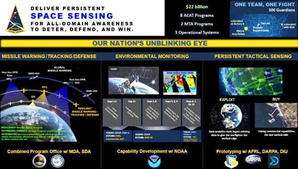
The Space Systems Command (SSC) Space Sensing program executive office, headquartered at Los Angeles Air Force Base in El Segundo, California, has delivered the first of two future operationally resilient ground evolution (FORGE) software deliveries to operations in the Overhead Persistent Infrared (OPIR) Battlespace Awareness Center (OBAC) at the Buckley Space Force Base in Colorado.
The integration of the FORGE framework into OBAC operations offers increased cyber resilience and enhanced mission applications to operators. OBAC operations on FORGE aim to boost OPIR battlespace awareness and technical intelligence missions with significant cyber-security improvements and enhanced missile detection and tracking.
Additionally, the operational trial period preparing for this delivery provided opportunities to stress the FORGE framework with real-world events. Notably, the framework performed in family with the legacy system, enabling the battlespace awareness and technical intelligence mission as the OBAC’s operational baseline.
FORGE provides OPIR data to operational warfighters and allows the U.S. Space Force to pivot toward a resilient missile warning, tracking and defense architecture. The FORGE ground system will support continued operations of legacy Space Based Infrared System (SBIRS), as well as the next generation of OPIR sensors including Next Gen OPIR GEO & Polar, and Resilient Missile Warning / Missile Track medium-Earth orbit (MEO) space systems. It has a cyber-resilient, flexible, scalable and government-owned open architecture to support the development, integration and delivery of OPIR processing applications for rapid response to emerging threats.
“Our nation’s ability to quickly sense and make sense of OPIR observations is crucial in maintaining decision-making advantage against adversarial threats and their advanced missile technologies,” said U.S. Space Force Col. Robert Davis, Space Force program executive officer for Space Sensing. “This effort enables target tracking earlier and for a longer duration, which significantly increases the event custody chain. Timely response to threats requires a modern architecture capable of hosting data from a range of new and legacy sensors that enables the development of applications to address these threats.”
The FORGE framework promotes open architectures designed to maximize the use of the OPIR constellation and allow for new capabilities to be added frequently and efficiently. It uses existing commercial off-the-shelf (COTS), government off-the-shelf (GOTS), and free or open-source software (FOSS) products to offer users a rapid pivot to new solutions depending on mission needs. This strategy enhances the opportunities for a broad range of vendors and strengthens the government’s access to the latest industry innovations, thereby increasing resiliency in the weapon system and industrial base, according to SSC.
The U.S. Space Systems Command (SSC), part of the United States Space Force, is actively seeking insights from the GNSS industry through a Request for Information (RFI) regarding the development of a Global Positioning System (GPS) Rapid Prototype Demonstration, Tranche 0.
This initiative is part of a strategic effort to upgrade GPS capabilities to meet modern challenges in space navigation and ensure continued operational superiority. This RFI aims to collect information about the industry’s capacity to innovate and deliver solutions that can enhance the GPS infrastructure. The focus is on identifying technologies and approaches that can reduce the size, weight, power and cost (SWaP-C) of future GPS satellites, streamline their production and launch processes and improve compatibility with a variety of launch vehicles.
According to the SSC, the goal of Tranche 0 is to create a prototype satellite that can emit certain GPS signals that are compatible with existing user equipment. The operation of this prototype in medium-Earth orbit (MEO), approximately 20,000 km above Earth, aims to test and validate these innovations in a real-world setting. The SSC’s approach aims to encourage collaboration, inviting both established and emerging players in the industry to showcase their abilities in rapid development, fabrication, and integration of GPS payloads.
Respondents to the RFI are reminded to adhere to security protocols to ensure that all submissions are unclassified, though they may include Controlled Unclassified Information (CUI) if properly marked. The SSC has also provided references to essential GPS Interface Control Documents (ICDs) and performance standards.
It may be hard to remember — or imagine — life without the Global Positioning System (GPS). From finding the nearest Dunkin’ Donuts to making ATM withdrawals, GPS is part of everyday life. It makes global finance possible, first responders faster, electric grids smarter and industries more efficient. Without GPS, the critical infrastructure that powers homes and workspaces, mobilizes roads and rails, guides air travel, delivers news and even produces food could come to a grinding halt. That fact is not lost on the United States’ adversaries.
Modernizing GPS to make it work better in times of peace and to ensure its resilience in times of conflict is a prime responsibility of the Space Systems Command (SSC) of the U.S. Space Force (USSF).
History
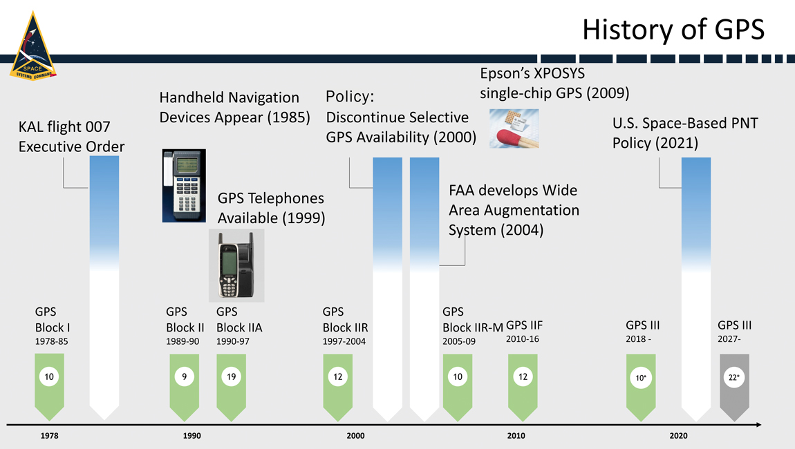
When it comes to anniversaries, 2023 is a big year for GPS. It’s widely considered to be the 50-year anniversary of GPS because it was on December 17, 1973, that the Defense Systems Acquisition Review Council (DSARC) gave U.S. Air Force Col. Bradford Parkinson, now retired and hailed as the father of GPS by many in the aeronautics and astronautics sectors, approval to proceed with development of what would become today’s 31-satellite GPS constellation.
It also marks 40 years since President Ronald Reagan authorized the use of GPS for civil aviation following the downing of Korean Air Lines Flight 007, after it inadvertently entered hostile air space. This year is also GPS’s 30-year anniversary of initial operating capability and the 20-year anniversary of the Federal Aviation Administration (FAA) Wide Area Augmentation System (WAAS), which enhances the accuracy and integrity of GPS services across the entire National Airspace System.
At the most recent meeting of the Civil GPS Service Interface Committee, the recognized worldwide forum for effective interaction between civil GPS users and GPS authorities, Parkinson — who, after his service in the U.S. Air Force earned a Ph.D. and has been a professor at Stanford University for decades — recounted his first-hand experience making GPS a reality. The former chief architect for GPS, who led original advocacy for the system as an Air Force colonel, described the incredible challenges and numerous unique innovations involved in starting this program.
Today’s GPS continues to deliver on its commitments for accuracy, integrity, availability, continuity and coverage. It is considered by many the gold standard in navigation and timing. Yet challenges remain, posed by an increasingly contested space domain and emerging threats from pacing challengers and adversarial nations. Advancing, maintaining and modernizing the GPS enterprise for the benefit of commercial, civil and military users falls under the responsibility of SSC and is carried out by the field command’s Military Communications and Positioning, Navigation & Timing program executive office (SSC/MilComm & PNT), in collaboration with its exceptional mission partners, and launch services provided by SSC’s Assured Access to Space program executive office.
As we celebrate the multiple GPS anniversaries, it is worth exploring successes in GPS modernization. This update will explore the exciting advancements in the GPS space systems, user equipment, and control systems.
Space Systems
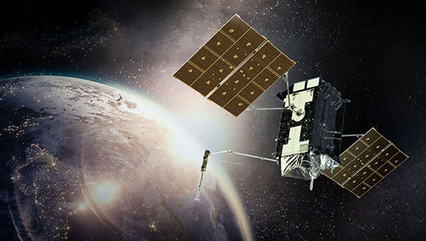
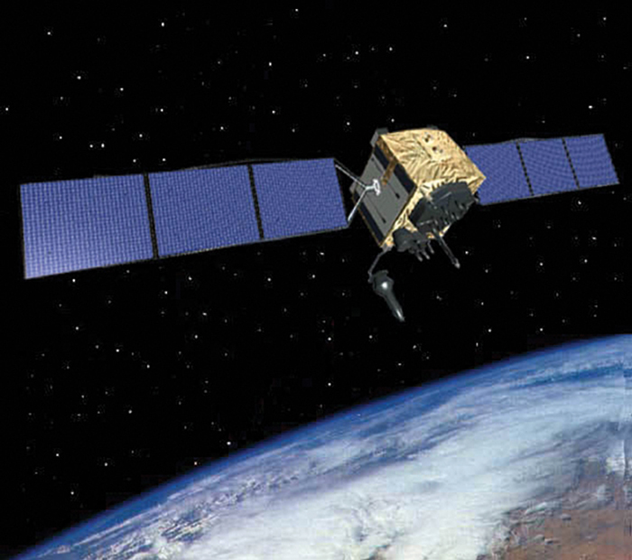
On January 18, the Lockheed Martin GPS III Space Vehicle 6 (SV06) launched into orbit aboard the SpaceX Falcon 9 Block 5 rocket out of Cape Canaveral, Florida. The successful launch of SV06 and handoff to the USSF’s Space Operations Command/Space Delta 8/2nd Space Operations Squadron marked another key step in the larger goal of modernizing the GPS constellation. SV06 is the sixth GPS III satellite to be launched and is equipped with the full suite of modernized signals and capabilities. The GPS III satellites are more capable and resilient than their predecessors. Improvements include three times greater accuracy and up to eight times improved anti-jamming capabilities.
In preparation for future launches, the GPS III team has been diligently working with the Assured Access to Space Launch Enterprise to ensure rigorous and successful integration of the GPS III spacecraft’s launch systems onto a brand-new rocket, the United Launch Alliance Vulcan Launch Vehicle. GPS III SV07/Vulcan is targeted for launch in the summer of 2024.
Additionally, production of the tenth and final space vehicle in the GPS III fleet was finalized this year and it has a target launch date of 2026. GPS III Space Vehicles 7-10 are in storage and available for launch, awaiting launch call-up.
The modernization, however, doesn’t end there. GPS IIIF continued to make progress this year with development and integration of the follow-on spacecraft program with 10 vehicles now in production. GPS IIIF Non-Flight Satellite Testbed completed panel integration and initial system performance testing and the program completed an integrated baseline review. The GPS IIIF team worked with the National Security Agency to successfully complete an information assurance preliminary design review, one of the first such reviews of its kind. The team has also made essential inputs to the planning for the future GPS IIIF launch and checkout capability.
GPS III Space Vehicle 06 (SV06) was launched Jan. 18 from Cape Canaveral Space Force Station in Florida. It is the 18th GPS satellite to broadcast the L5 signal.
User Equipment
SSC/MilComm & PNT actively manages and maintains the public GPS interface specifications that allow industry to build civil receivers that successfully capture and process the GPS signal-in-space satellite-broadcast. Simultaneously, SSC also leads design and development of military receivers, currently the Military GPS User Equipment (MGUE). In April, the MGUE Increment 1 team successfully completed technical requirements verification on its MGUE GPS receiver application module — a standard electronic module specifically designed for aviation and maritime users. This allowed the MGUE Inc 1 program to deliver its new aviation and maritime software to the U.S. Air Force and U.S. Navy to support the lead platform integration and testing on the B-2 Spirit bomber and the Arleigh Burke guided-missile destroyer. This is the first fully functional GPS aviation and maritime software suite to support the jam-resistant military M-code signal.
GPS has an active and successful foreign military sales (FMS) program with 60 allied partners, and many of them are highly engaged with SSC/MilComm & PNT to acquire MGUE receivers with their M-code capabilities. According to the Department of State, U.S. allies and partners purchase approximately $45 billion annually in arms, equipment, and training — many equipped with GPS — via FMS.
This spring, the MGUE Increment 2 team, developing an advanced, follow-on receiver, completed the new Next Generation Application-Specific Integrated Circuit (ASIC), the first of two major Critical Design Reviews (CDRs) with mission partner BAE Systems. That success was followed by a second CDR this summer for the MGUE Increment 2 Miniature Serial Interface (MSI) receiver card, which integrates the Next Generation ASIC along with a host of other innovations. L3Harris, a mission partner, has also successfully completed its own next generation ASIC CDR and is on-track for an MSI CDR in October. MGUE Increment 2 also awarded a Joint Modernized Handheld contract to the Technology Advancement Group, enabling this industry partner to move forward on its MGUE Increment 2 Handheld initiative.
Control Systems
While the current operational control system continues performing at a high level, a major update to the GPS modernization architecture is underway. In March 2022, the USSF began formal testing of the Next Generation Operational Control System (OCX) Block 1/2 system through the Functional Qualification Test designed to test OCX requirements. Currently, preparations are underway to follow that up with a major government-led Integrated Systems Test.
OCX developmental testing is an important part of the software development process. Thorough developmental testing can help ensure that OCX is of high quality and meets all requirements. Testing is rigorous and comprehensive; it is a complex and challenging undertaking, but one necessary to ensure OCX is ready for operational use before it is transitioned into service. SSC’s program office is taking the necessary steps to ensure that it will be a success.
The OCX 3F program also contributes to SSC’s advancements in GPS control systems. The follow-on to OCX for support to GPS IIIF spacecraft has successfully completed a Critical Capability Release for the GPS IIIF launch and checkout capability.
GPS IIF
Sustainment
SSC/MilComm & PNT’s GPS Support Delta has a legacy of providing sustainment expertise for Space Operations Command’s operations team. It sustains a global network including a Master Control Station (MCS), Alternate MCS, 11 command-and-control antennas, and 16 monitoring sites, plus 38 on-orbit GPS spacecraft. The sustainment team performs seamlessly, anticipating issues, collaborating with operators, updating servers and software tools, enhancing cyber secutiry and fine-tuning GPS to keep it running at peak performance.
Future Opportunities
In 2019, the department of the Air Force designated the Navigation Technology Satellite-3 (NTS-3) as a Vanguard program and the Department of Defense’s first experimental integrated navigation satellite system in nearly 50 years. Co-sponsored by SSC and the Air Force Research Laboratory, NTS-3 is helping to pave the way for more robust and resilient positioning, navigation, and timing.
In June, SSC/MilComm & PNT hosted its first Alternate/Augmented PNT Reverse Industry Day at SSC’s new Commercial Space Marketplace for Innovation and Collaboration Center. The event was a unique opportunity for government leaders and technical experts to hear directly from industry in a one-on-one environment about their many exciting innovations and opportunities as well as challenges. SSC was joined by its close government and interagency partners, including representatives from the Department of Transportation, the National Space-Based PNT Coordination Office, the Space Operations Command/Mission Area Team, the Air Force Research Laboratory, and the Space Development Agency. Through the event, SSC gained market intelligence and made many valuable industry connections for future investments.
Conclusion
As the nation celebrates an exciting 50-year anniversary of GPS, continued enhancements in the three elements of the GPS enterprise — space systems, user equipment, and control systems — represent significant milestones toward GPS modernization. This essential upgrade is delivering many new GPS capabilities — including robust new signals such as M-code, L2C, L5, and L1C — while preserving backward compatibility for GPS legacy signal users. GPS modernization will enhance utility, make the system more robust and resilient, and ensure that the United States, its allies, and its government agency partners have access to the most accurate and reliable navigation and timing services available. At the same time, while we continue to look for ways to (in the words of the National Space-Based PNT Advisory Board) “protect, toughen, and augment” GPS capabilities, we are also actively engaged in evaluating ways to incorporate alternate sources of PNT, as well as GPS augmentation, that will continue to make PNT capabilities even more robust and resilient in the future.
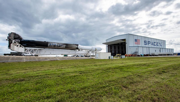
SpaceX’s Falcon Heavy rocket begins its roll out to the historic Launch Complex (LC)-39A at NASA’s Kennedy Space Center in Florida. (Image: SpaceX)
Space Systems Command (SSC) and SpaceX are preparing to launch the U.S. Space Force (USSF)-52 mission into orbit. The Falcon Heavy mission is set to launch on Dec. 10, 2023, from the historic Launch Complex (LC)-39A at NASA’s John F. Kennedy Space Center in Florida.
USSF-52 is the seventh mission of the X-37B Orbital Test Vehicle, an experimental program with technologies designed to provide the U.S. Space Force with a reliable, reusable, unmanned space test platform.
This launch adds to a notable year. The last NSSL Falcon Heavy launched in early January; that mission, USSF-67, was followed by a Falcon 9 launching a GPS satellite 61 hours later, both from the Eastern Range and using the same Space Systems Command crew. The Assured Access to Space team worked alongside SpaceX to complete both launches.
In preparation for a challenging and busy launch schedule, the U.S. Space Force is placing greater importance on being agile and resilient. The ability to conduct launch operations at a faster pace will be particularly crucial for successfully deploying multiple constellations, the Space Force said.
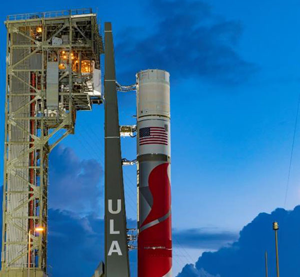
The ULA Vulcan Centaur launch vehicle. (Image: ULA)
The United States Space Force’s Space Systems Command (SSC) has assigned 21 launch service mission assignments for the National Security Space Launch (NSSL) Phase 2 Launch Service Procurement contract. This is the fifth and final order year in the Phase 2 contract.
United Launch Alliance (ULA) received 11 mission assignments and SpaceX received 10. These missions are scheduled to launch over the next two to three years and focus on a variety of mission areas.
The 11 missions assigned to ULA are: GPS III-9, NROL-73, NROL-56, STP-5, SILENTBARKER 2/NROL-118, GPS IIIF-1, NROL-100, USSF-95, NROL-109, SDA T2TL-B and USSF-25.
The 10 missions assigned to SpaceX are: SDA T1TL-F, SDA T1TR-A, USSF-57, NROL-77, SDA T1TR-E, GPS III-10, USSF-75, SDA T2TL-A, SDA T2TL-C and USSF-70.
NROL-77, NROL-73, NROL-56, NROL-109, and NROL-100 are missions being conducted in partnership with the National Reconnaissance Office (NRO).
T1TL-F is the last mission of six Space Development Agency (SDA) Tranche 1 Transport Layer launches. T2TL-A, T2TL-B and T2TL-C are the first three Tranche 2 Transport Layer launches. SDA’s Transport Layer aims to provide assured, resilient, low-latency military data and connectivity worldwide to the full range of warfighter platforms.
T1TR-A and T1TR-E are the last two SDA Tranche 1 Tracking Layer launches. The Tracking Layer aims to provide global indications, warning, tracking and targeting of advanced missile threats, including hypersonic missile systems.
The GPS III-9 and GPS III-10 missions are the final projected GPS III missions. The GPS IIIF-1 is the first launch of the follow-on GPS III satellites. GPS Block IIIF introduces several improvements and novel capabilities compared to previous GPS satellite blocks.
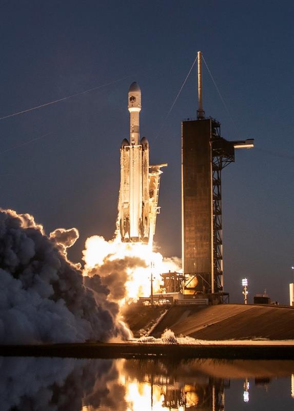
SpaceX’s Falcon Heavy launch vehicle. (Image: SpaceX)
USSF-57 will launch the first of three next generation overhead persistent infrared GEO satellites. These satellites will deliver survivable, resilient missile warning, tracking, and defense in a highly contested and congested space domain.
SILENTBARKER 2/NROL-118 is a joint NRO and SSC Space Domain Awareness mission to meet U.S. Department of Defense (DOD) and intelligence community space protection needs.
USSF-25 will launch the Defense Advanced Research Projects Agency’s Demonstration Rocket for Agile Cislunar Operations (DRACO). The goal of the DRACO program is to demonstrate nuclear thermal rocket in orbit.
USSF-95 will be the first launch of a missile track custody (MTC) prototype satellite. The MTC prototype effort will evaluate the ability of various next generation overhead persistent infrared sensor designs to meet missile tracking requirements.
STP-5 is the latest mission in support of SSC’s Space Test Program (STP). The STP performs mission design, payload-to-bus integration, space vehicle-to-launch vehicle integration, and on-orbit operations for science and technology payloads that exhibit potential military utility. STP-5 will launch two satellites in support of the DOD’s Strategic Capabilities Office.