Tag: Florida

  • UAV updates: Attack drones deployed in the Iran conflict and autonomous boats at RoboBoat 2026

    UAV updates: Attack drones deployed in the Iran conflict and autonomous boats at RoboBoat 2026

    The war between Israel, the United States and Iran has dominated headlines since it began with surprise attacks launched by Israel and the U.S. on the last day of February. Significant damage has since been inflicted on Iran as the allies seek to end the country’s nuclear capabilities and bring about regime change — removing those responsible for worldwide terrorism through its proxy groups, including Hezbollah, the Houthi movement in Yemen, various Iraqi Shiite militias, Hamas and Islamic Jihad, all of which have targeted Western countries and Israel.

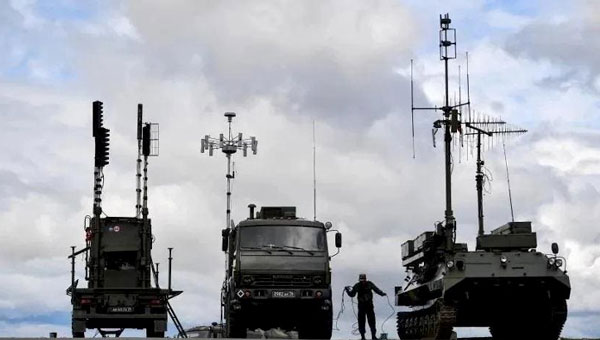
    Iran maintains a formidable military with more than 600,000 active-duty personnel, an estimated 2,000 to 3,000 ballistic and shorter-range missiles, and a significant offensive drone capability. The Shahed series and Mohajer-6 drones have emerged as low-cost kamikaze weapons central to Iran’s arsenal. The Shahed-136 in particular has been supplied in large quantities to Russia for use in its ongoing war against Ukraine and is now also manufactured by Russia, or a version of it is. The Shahed drone has several variants, including the jet-powered, long-range Shahed-238.

    Iranian Shahed-136 attack drones, read for launch. (Photo: IMA Media)
    Iranian Shahed-136 attack drones, read for launch. (Photo: IMA Media)

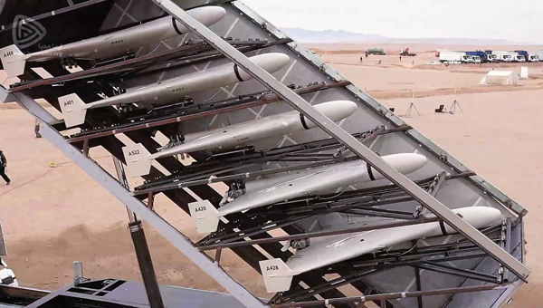
    With a range of 800 miles to 1550 miles, the Shahed-136 carries an 88-pound warhead which can punch very large holes in buildings, disable oil tankers or warships, destroy equipment on the ground, and kill and injure lots of personnel. It’s possible that those six US servicemen killed and others injured during the early hours of the conflict in Port Shuaiba, Kuwait, were victims of a Shahed kamikaze drone attack.

    This is not all bad news: the U.S. has analyzed captured downed Shahed-136 drones and has quickly replicated its own version, the Low-cost Unmanned Combat Attack System (LUCAS), admittedly with a shorter range but just as deadly. It’s reported that the Iranians can build and mass-produce thousands of drones for between $20 and $50,000 each. Nevertheless, the U.S. has now been producing large volumes of LUCAS, and has them to fight in Iran.   

    LUCAS is already in US volume production. (Photo: US Central Command)
    LUCAS is already in US volume production. (Photo: US Central Command)

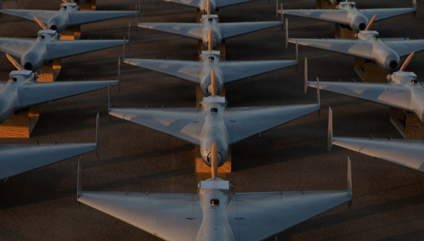
    Spektraworks, based in Phoenix, was awarded a $30 million contract, and within 18 months, a redesigned, hardened and autonomously coordinated attack drone — manufactured in the U.S. at a cost of approximately $43,000 per unit — became available in significant quantities and was fielded to U.S. Central Command’s newly formed drone task force, Task Force Scorpion Strike.

    The unit was responsible for the Shahed-like drones seen flying over Baghdad in early television coverage as the U.S. offensive got underway.

    It marks a notable achievement — delivering similarly designed attack drones, and the destruction they carry, back to Iran, a country that has exported terror to numerous nations for more than 50 years.


    Meanwhile, the 2026 RoboBoat Competition took place at Nathan Benderson Park near Sarasota, Florida, drawing 37 high school and university teams. The event challenges students to demonstrate progress in developing autonomously operating marine systems installed on model boats. Benderson Park features a large rowing lake that has hosted Olympic rowing and canoe trials, making it a fitting venue for RoboBoat competitors and spectators.

    Teams arrived with a wide variety of model boat designs and technical approaches, navigating through a series of in-water obstacle courses while gaining hands-on experience relevant to future careers. Volunteer support was plentiful, and each team brought cheering crews and technical assistance. Typical tasks included restoring simulated harbor operations, assessing underwater infrastructure and supporting exploration scenarios.

    After watching more than 2 hours of posted videos, it is clear that the competition is run by a volunteer student organization. The final-round objectives were not clearly defined, and without commentary, it was difficult to determine whether any team successfully completed the obstacle course — though several boats did navigate between narrow red and green buoys after avoiding a series of posts in the water.

    RoboBoat 2026
    RoboBoat 2026

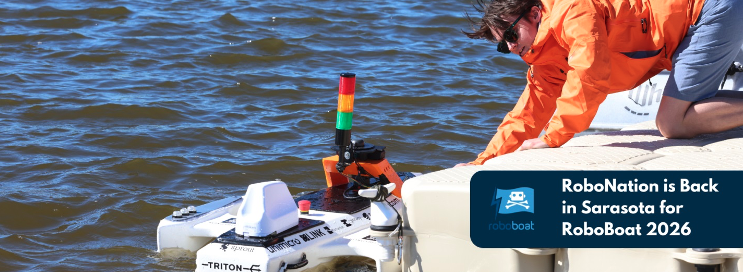
    Nevertheless, it was great to see the whole gathering, many from overseas, and the level of enthusiasm. One guy told the story of how the team’s heavy equipment had survived a long-distance shipment from overseas and arrived almost intact. But during the competition, the quite heavy demo boat sank; it was just a minor setback for him — we’ll learn something and keep going!  — was his mantra. As everyone in the industry knows, having your tested, verified, and 100% reliable set-up actually function at a trade show is a major hurdle we’ve all had to overcome. So, it’s good to see these young men and women learn firsthand what it takes to get a prototype to work when it becomes absolutely essential – and of course, to actually make progress and extend their reach towards autonomous robotics.


    The U.S. military has been throwing Shahed-like kamikaze weaponized drones back at the country that had not only invented them, but also spread the technology to and through other antagonists, yet now feeling their impact on their own capital city — a significant success for the initial U.S. attack on Iran. And growing and supporting the latest wave of students and their autonomous aspirations at RoboBoat 2026 in Florida. One aspect of UAVs is warlike and deadly, while another is encouraging young engineering candidates towards their dreams of maritime robotic autonomy.

  • DAF launches NTS-3 Vanguard on ULA Vulcan Rocket

    DAF launches NTS-3 Vanguard on ULA Vulcan Rocket

    The Department of the Air Force (DAF) has successfully launched the Navigation Technology Satellite-3 (NTS-3) Vanguard aboard the United Launch Alliance (ULA) Vulcan rocket on the USSF-106 mission from Cape Canaveral Space Force Station, Florida, on August 12, 2025. This mission marks the first U.S. national security payload launched on the Vulcan Centaur rocket, which represents a new era of launch vehicle capability for national defense.

    “We have a strategic imperative to deliver science and technology that enables and accelerates a resilient hybrid space architecture for the space capabilities that the joint force depends on,” said Air Force Research Laboratory (AFRL) Commander and DAF Technology Executive Officer (TEO), Brig. Gen. Jason E. Bartolomei.

    NTS-3’s Advanced Architecture

    NTS-3 is an experimental integrated navigation satellite designed by the AFRL to enhance the robustness, resilience and responsiveness of space-based positioning, navigation and timing (PNT) services, crucial to both military and civilian applications. The satellite aims to advance the capabilities of existing global navigation satellite systems, such as GPS, through innovative technology that includes an advanced atomic clock timekeeping system, a reprogrammable receiver compatible with both legacy and advanced signals (the Global Navigation Satellite System Test Architecture), and Chips Message Robust Authentication, which defends against GPS spoofing.

    NTS-3 features a fully reprogrammable software architecture that spans the space-based satellite, ground-based control system, and agile user receivers. This enables rapid software updates either on orbit or in the field, a significant departure from previous GPS satellites that required hardware changes for upgrades. This approach delivers not only military advantages in contested environments but also substantial benefits for civilian users who rely heavily on GPS for banking, agriculture, telecommunications and air traffic control.

    “We rely on GPS so much, in ways that we don’t always think about,” said Rachel Gleichmann, NTS-3 deputy program manager, AFRL Space Vehicles Directorate. So, to make sure that it is resilient and that it’s always available and always accurate — or, as the military likes to say, ‘assured’ is extremely important to your average American.”

    Industry partner L3Harris Technologies serves as the prime contractor, working alongside AFRL on the design, development, integration, testing, launch vehicle interface, and on-orbit operations of the satellite. The collaboration embodies a comprehensive ecosystem approach that leverages resources from government, industry, academia, and venture capital to foster innovation in national security space.

    For more information on AFRL’s NTS-3 program, visit the Air Force Research Laboratory website.

  • SpaceX launches GPS III SV-08, boosting anti-jamming capabilities

    SpaceX launches GPS III SV-08, boosting anti-jamming capabilities

    SpaceX successfully launched the GPS III SV-08 satellite into orbit on May 30 from Cape Canaveral Space Force Station, marking a significant milestone for the U.S. Space Force’s rapid-response capabilities. The mission, executed in close coordination with Lockheed Martin and SpaceX, launched the eighth GPS III satellite into the constellation after an accelerated preparation period of just three months, well ahead of the traditional two-year timeline for national security launches.

    The GPS III SV-08, named after the pioneering NASA mathematician Ms. Katherine Johnson, is part of the next-generation GPS IIIF satellites designed to enhance accuracy and incorporate advanced anti-jamming features for both military and civilian users. Built by Lockheed Martin, the spacecraft is equipped with M-Code technology, delivering signals that are three times more accurate and eight times more resistant to jamming than previous generations. These improvements are critical as threats to GPS reliability, such as jamming and interference, continue to increase.

    In a press statement, Col. Andrew Menschner of the Space Force emphasized the urgency behind the accelerated launch schedule to mitigate increasing GPS jamming and interference: “There are 38 GPS satellites in orbit, 31 of which operate on a daily basis. We have a healthy redundancy in the constellation. But the addition of SV-08 allows the constellation to build resistance against those who would try to interfere with GPS signals.”

    This launch marks the second time the Space Force has demonstrated its ability to deploy a GPS satellite on a compressed schedule. The previous rapid-response mission, dubbed Rapid Response Trailblazer, saw the seventh GPS III satellite launched in December 2024 after five months of planning. For SV-08, the team further reduced the schedule by 40%, reflecting lessons learned and increased efficiency.

    Looking ahead, the final two GPS III satellites will be launched on United Launch Alliance’s Vulcan rocket, paving the way for the next-generation GPS IIIF satellites. According to Lockheed Martin, these spacecraft will introduce even greater anti-jamming capabilities, fully digital navigation payloads and advanced features such as regional military protection and improved search-and-rescue support, further enhancing the robustness and utility of the GPS constellation.

  • Space Force prepares for accelerated GPS III mission to enhance warfighter capabilities

    Space Force prepares for accelerated GPS III mission to enhance warfighter capabilities

    The U.S. Space Force’s Space Systems Command and Space Operations Command are preparing to launch the National Security Space Launch GPS III-7 mission, designated Space Vehicle 08, aboard a SpaceX Falcon 9 rocket. The launch is planned to take place from Space Launch Complex 40 at Cape Canaveral Space Force Station, Florida, no earlier than late May 2025.

    This mission follows the successful Rapid Response Trailblazer launch in December 2024 and represents another accelerated effort. It involves a coordinated operation across multiple Space Force organizations to retrieve a GPS III satellite from storage, integrate it with the launch vehicle, and prepare it for launch on a compressed timeline.

    The GPS III satellite is equipped with M-Code technology, which offers three times greater accuracy and eight times more resistance to jamming compared to earlier systems. This capability aims to enhance Precision, Navigation, and Timing services for the Joint Force, ensuring modernized support for military operations.

    This effort builds on lessons learned from the previous Rapid Response Trailblazer mission and demonstrates the Space Force’s ability to reduce standard launch preparation timelines. While such preparations typically require up to 24 months, this mission is set to be completed within three months.

    Mission Delta 31 of Space Operations Command is overseeing pre-launch processing in collaboration with Lockheed Martin in Colorado. On April 2, 2025, the satellite was transported to Florida aboard a U.S. Air Force C-17 Globemaster III and is now undergoing final preparations for launch. Col. Andrew Menschner, commander of Mission Delta 31, emphasized the teamwork involved in rapidly deploying an M-Code-capable satellite and advancing traditional launch timelines.

    Key aspects of this mission include space vehicle-to-launch vehicle integration, satellite control preparation, and expedited contracting efforts.

    The satellite is named in honor of Katherine Johnson, whose mathematical contributions were pivotal to early U.S. spaceflight missions. Once operational, it will enhance communication capabilities critical to national security and align with the Secretary of Defense’s strategic objectives by supporting military readiness with anti-jamming technology.

  • GPS III SV-07 becomes operational

    GPS III SV-07 becomes operational

    The U.S. Space Force transferred Satellite Control Authority of the GPS III Space Vehicle 07 (SV-07) to the 2nd Navigation Warfare Squadron, Mission Delta 31, at Schriever Space Force Base, Colorado. The satellite became operational and available to global users on Jan. 22, 2025 — expanding the GPS constellation to 31 active vehicles. The transfer is the first instance in which the Satellite Control Authority moved from the acquisition program to the operations squadron within a single Delta, reflecting the new mission delta structure. 

    The space vehicle was launched on Dec. 16, 2024, from Cape Canaveral Space Force Station, Florida, aboard a SpaceX Falcon 9 rocket as part of a Rapid Response Trailblazer mission. The operation involved retrieving an existing GPS III satellite from storage, expediting integration and launch vehicle preparation, and swiftly processing the satellite for launch. 

    The entire process, from initiation to launch, was completed in approximately three months, significantly shorter than the typical six-month pre-launch processing timeline. This accelerated timeline was achieved through collaboration between multiple Space Force organizations and partner agencies.

    The GPS III SV-07 satellite is equipped with M-code, designed to improve anti-jamming and anti-spoofing capabilities, enhancing secure access to military GPS signals. This launch contributes to the ongoing modernization of the GPS constellation following the launch of GPS III SV06 in 2023. Mission Delta 31, activated on Oct. 15, 2024, is responsible for providing, operating, and sustaining high-integrity positioning, navigation and timing (PNT) capabilities. It comprises three squadrons and one detachment, including the 2nd Navigation Warfare Squadron, which operates the GPS satellite constellation.

  • SpaceX launches GPS III satellite for US Space Force

    SpaceX launches GPS III satellite for US Space Force

    Following weather delays, the U.S. Space Force’s Space Systems Command (SSC) and Space Operations Command expedited the Rapid Response Trailblazer launch schedule to fulfill a specific warfighter requirement. On Dec. 16, 2024, SpaceX’s Falcon 9 rocket launched the GPS III SV-07 satellite from Space Launch Complex 40 at Cape Canaveral Space Force Station, Florida.

    For the mission, multiple Space Force organizations collaborated to retrieve an existing GPS III satellite from storage, expedite integration and launch vehicle preparation, which was quickly processed for launch. The success of the launch proved a two-fold concept of operations. SSC’s Assured Access to Space showcased its agility in partnering with industry to meet evolving national needs, completing a National Security Space class launch in less than five months.

    This marks the first Space Operations Command mission led by Mission Delta 31 for a Space Vehicle launch, and it demonstrated exceptional flexibility by reducing the typical six-month pre-launch processing timeline to approximately three months, Space Operations Command said. This effort involved close coordination with Lockheed Martin in Colorado to rapidly prepare SV-07 for launch.

    The GPS III SV-07 satellite joins a robust constellation comprising 31 active vehicles, seven in reserve status and three completed GPS III vehicles awaiting launch. Equipped with M-Code technology, these satellites offer improved anti-jamming and anti-spoofing capabilities, enhancing secure access to military GPS signals for U.S. and allied forces.

  • How GPS aids in Hurricane Helene recovery efforts

    How GPS aids in Hurricane Helene recovery efforts

    Hurricane Helene has caused widespread devastation across the southeastern United States, leaving a trail of destruction more than 500 miles long from Florida to the Carolinas. The storm made landfall at the Big Bend of Florida, on Sept. 26, 2024, as a Category 4 hurricane with sustained winds of 140 mph.  

    The death toll has risen to at least 215 across six states, with hundreds more still unaccounted for, reported ABC News. More than 4.5 million people initially lost power due to the hurricane, with more than two million residents still without electricity days after the storm. Utility companies face significant challenges in restoring power due to blocked and damaged roads. The storm’s destruction has rendered many essential roads and bridges impassable, complicating recovery efforts. 

    Role of GNSS in Recovery  

    GNSS plays a crucial role in disaster recovery operations. These systems provide essential positioning, navigation and timing (PNT) services critical for search and rescue efforts such as flood monitoring. GNSS technology enhances emergency services by enabling synchronized communication networks, providing precise location information and allowing for faster response times. With cell towers and electrical services down, GNSS empowers virtually all disaster recovery efforts.  

    Over the years, our reliance on GNSS has increased into an aspect of life we often overlook. Its importance is emphasized in times of disaster, PNT is critical.  

    A recent public safety announcement issued by the Space Force highlights that a critical component of any successful rescue operation is time. Knowing the precise location of landmarks, streets, buildings, emergency service resources and disaster relief sites reduces the time it takes to navigate challenging terrains to save lives. This information is critical to disaster relief teams and public safety personnel in order to protect life and reduce property loss. GPS serves as the fundamental technology in addressing these needs. 

    The United States Geological Survey (USGS) is also collecting flood data and repairing damaged streamgages to monitor water levels after Hurricane Helene. 

    USGS Mapping the Aftermath  

    As of Oct. 7, USGS provisional streamgage data indicates that at least 34 new flood records were set across the southeast from flooding caused by Helene. Eighteen of these provisional records were set in North Carolina, with six in Tennessee, six in South Carolina, three in Florida and one in Georgia.  

    In Newport, Tennessee, USGS field crews were able to measure high-water marks left behind by flood waters and determined the Pigeon River reached a provisional peak water level of 29.72 ft. The previous record on this river was 21.40 ft, set in 1902. 

    As communities begin the long process of rebuilding, they face numerous challenges, including limited resources, prolonged power outages and disrupted communication systems. However, GPS serves as a backbone in the recovery process, highlighting its significance in times of disaster. The full extent of Hurricane Helene’s impact is still being assessed, with authorities warning the death toll may continue to rise as search and rescue efforts progress. 

  • Galileo constellation expands with two new satellites

    Galileo constellation expands with two new satellites

    Photo: SpaceX
    Photo: SpaceX

    SpaceX has launched the latest pair of Galileo satellites from the Kennedy Space Center in Florida. The SpaceX Falcon 9 rocket carried satellites 31 and 32 (FM26 and FM32) to their designated orbits.

    This launch, number 13 in the Galileo program, marks a crucial milestone in the constellation’s development. The addition of these satellites completes the designed constellation, with the required operational satellites plus one spare per orbital plane. The new pair will undergo testing at their final altitude of 23,222 km before becoming operational.

    European Space Agency (ESA) Director of Navigation Javier Benedicto highlighted the importance of this launch, stating that the remaining six Galileo First Generation satellites are scheduled for deployment in 2025 and 2026.

    These additional satellites are designed to enhance the system’s performance and reliability further, ensuring uninterrupted delivery of highly precise navigation services.

    At ION GNSS+ 2024, Eric Châtre, head of EU GNSS exploitation and evolution at the European Commission, and Miguel Manteiga, Galileo project manager at ESA, participated in a panel titled “Status of GPS, Galileo, BDS, QZSS, KPS and NavIC.” They shared how 2024 has been a particularly eventful year for the Galileo program. In April, satellites 29 and 30 were launched and entered service in September. The new Public Regulated Service (PRS) signals began broadcasting, offering encrypted navigation for authorized governmental users. A significant upgrade of Galileo’s ground segment was completed without impacting users.

    The Galileo system continues to evolve, with the development of Second Generation (G2) satellites underway. These satellites will feature fully digital navigation payloads, electric propulsion and inter-satellite link capacity.

  • New Galileo satellites declared operational

    New Galileo satellites declared operational

    Galileo satellites 29 and 30 have reached their target positions at an altitude of 23,222 km and are now fully operational three months after being launched from Cape Canaveral, Florida, by SpaceX. These new additions to the Galileo constellation are now active and provide navigation signals to users.

    Both satellites have been positioned on the same orbital plane, one of three that comprise the Galileo constellation. With this latest addition, two of the three Galileo orbital planes are fully populated, bringing the constellation close to completion. The next Galileo launch is planned in the coming weeks from the Kennedy Space Center in Florida onboard a SpaceX Falcon 9.

    The Galileo Service Operator, supported by a team of approximately 30 satellite experts from the European Space Agency (ESA) and satellite manufacturer OHB, conducted early operations at the Galileo Control Centre in Oberpfaffenhofen, Germany, under supervision from the European Union Agency for the Space Programme (EUSPA). Following the initial operations, the satellites entered a drift phase, during which ground teams guided them to their final positions, which was reached on June 24.

    On August 21, 2024, ESA, OHB and payload manufacturer SSTL evaluated the in-orbit test results, confirming that the satellites had not experienced any degradation during launch. ESA, in collaboration with EUSPA, then validated the satellites’ performance at the system level.

  • SpaceX successfully launches Galileo GNSS satellites

    SpaceX successfully launches Galileo GNSS satellites

    Photo: SpaceX
    Photo: SpaceX

    On April 27, 2024 the SpaceX Falcon 9 medium-lift launch vehicle launched into orbit Galileo satellites GM25 and FM27 from Kennedy Space Center in Florida. This was Falcon 9’s 20th and final launch.

    The EU Agency for the Space Programme (EUSPA) confirmed in a statement that it is now in the Launch and Early Orbit Phase (LEOP) stage of the two new L12 Galileo satellites. They will join the current Galileo operational fleet in the upcoming months. The latest batch of Galileo satellites are being operated by EUSPA and the Galileo Service Operator for the Early Orbit Phase (EOP).

    The EUSPA operations team, through its Galileo Service Operations provider, took over the satellite operations as the satellites were separated from the launch vehicle and their automated initialization sequence started. Telemetry has been successfully acquired, their solar panels deployed and the batteries are charging, bringing the satellites to what is called the Holding Point, according to EUSPA.

    The EOP is a vital step in a space mission, running through the gradual activation and testing of platform satellite components, once in orbit. From the Galileo Control Centre in Oberpfaffenhofen, Germany, the dedicated LEOP team will navigate the satellites to their designated orbit within the coming days. Following rigorous in-orbit testing and commissioning, the satellites will integrate into Galileo’s operational constellation at 23,220 km.

    The mission is a collaboration between the European Commission, which lead the management of Galileo; EUSPA, which manages operations and services with the support of the Galileo service operator (SpaceOpal); and the European Space Agency (ESA), which serves as the design authority, responsible for development.

  • Jamming warfare and air taxis

    Jamming warfare and air taxis

    Russian Pole-21 jammer – (photo: Defense Ministry, Russia)
    Russian Pole-21 jammer – (Image: Defense Ministry, Russia)

    Other than the tracked unit — a truck that appears to be a power generator and has an overall look of complexity — the thing that jumps out at you about the Russian Pole-21 jammer is that it is brisling with a huge number of antennae. The system apparently can jam almost any known communication channel and everything GNSS. It is a bit lumbering to move around, may be difficult to set up, and must be used judicially, because it may jam everything, including the Russian’s own coms and GLONASS navigation systems. So, it may be useful for disabling the enemy, but only when your own soldiers have already established visual contact with their target.

    The Russians just parked one of these contraptions in southern Ukraine’s Zaporizhzhia Oblast (district), which has been the focus of the Ukrainian counteroffensive for the last few months. However, the Ukrainians found it quickly, had time to figure out what to do with it and launched a GPS-guided weapon that destroyed the inoperative Pole-21 jammer. They may have caught the system either before it was fully activated or when it had been intentionally shut down to protect Russian forces. The Pole-21 set up was found during a drone recognizance flight and the system was then taken out by a Ukrainian aircraft — perhaps a Russian Sukhoi Su-27 or Mikoyan MiG-29 — which deployed a U.S. Joint Direct Attack Munition (JDAM) to destroy the system. The UAV, the aircraft, and the JDAM all use GPS for guidance, which is perhaps a little ironic. The Ukrainians have reportedly destroyed more than four dozen other Russian jamming systems since the start of the war.

    Just in case there might be reprisals, the Ukrainians have developed their own RF system that forms a 600-ft dome over the area/asset that needs protection from UAV attacks. Additionally, Western countries have supplied several jamming systems to the Ukrainian forces for more elaborate, wider range jamming protection.

    Ukraine initially shot down low flying, slow Russian UAVs with rifles and large caliber anti-aircraft defense systems; however, as expensive missile systems have become available from the United States and elsewhere, it has become apparent that it is too expensive to use complex missiles to bring down large numbers of inexpensive commercial UAVs. It just does not make sense — too many UAVs and not enough expensive missiles. Ukraine has thrown large numbers of cheap UAVs — some even made from cardboard — in the other direction, at a significant cost for the missiles shot at them by Moscow’s air-defense system.

    Counter-UAV (C-UAV) technology must be an alternative, and several suppliers can readily provide affordable production equipment. Tactics range from firing anti-aircraft gun batteries to intercepting drones using nets, or just crashing UAVs into interlopers, or more prevalently using electronic disruption systems — such as the DroneGun Tactical “arm-held” from DroneShield — which jams the control signals and/or GNSS guidance.

    A large proportion of “attack-UAVs” are simply modified off-the-shelf commercial vehicles adapted to carry explosives, even existing conventional ordinance — read “bombs”. The UAVs themselves are built with commercial components, which have little resistance to directed jamming frequencies that overpower the RF section of the receiver. Then, there is loss of lock on the coms and/or the very low power GNSS signal — where signal processing stops, and guidance is lost.


    Meanwhile, back in our much safer land of commercial aviation, progress toward the emergence of electric vertical take-off-and-landing (eVTOL) air taxis took a simple step forward, at Tampa International Airport (TPA), Florida.

    TPA growth plan of the Tampa airport. (Image: FAA)
    TPA growth plan of the Tampa airport. (Image: FAA)

    TPA is in the midst of a significant growth spurt that began last year with moving the rental car facility off site to make more space and installing a rail link to restore access for renters to the main terminal. Upcoming is a new Airside D set of 16 additional gates, and future provisions for urban air mobility, enabling eVTOL air taxi traffic services in and around the airport to bring passengers directly to the airport from their local catchment areas. Possible locations have been identified for one or two vertiports on the airport grounds, and an airport integration plan appears to be well underway.

    Last week, Volocopter, a German company, showed up at TPA with its VeloCity two-seater prototype air taxi to carry out the very first tests of a passenger-carrying UAM vehicle at a major U.S. airport. The Tampa and St. Petersburg mayors were on hand, as were airport management and others from the aviation and transportation industry.

    VeloCity prototype in clear skies at Tampa. (Image: courtesy of courtesy BoxAdmin/Beau Zimmer/Velocopter)
    VeloCity prototype in clear skies at Tampa. (Image: courtesy of courtesy BoxAdmin/Beau Zimmer/Velocopter)

    Now TPA is a busy place, with 553 flights daily into and out of the facility, but Volocopter was able to fit into the infrastructure and perform two flight tests with the U.S. Federal Aviation Administration (FAA) to investigate aircraft downwash and outwash, along with aircraft performance in TPA’s actual environmental conditions.

    Various prototypes of the VoloCity have already flown 2,000 flights. Initial operational flights will be flown by a pilot with only one passenger. However, as operational reliability is proven, a fully autonomous service is planned. Volocopter is currently focusing on certification of the VoloCity, by the European Union Aviation Safety Agency (EASA) in 2024, leading to initial service on three routes in Paris, France. Concurrent validation in cooperation with the FAA, originally submitted in 2020, is also progressing.


    In conclusion, GNSS and communications jamming is escalating in and around Ukraine as the war drags on and each side tries to compensate, while efforts to revolutionize shuttle services for passengers to and from major airports in the United States has taken quite positive steps in Tampa, Florida.

  • Seen & heard: Catching crime and tracking songbirds

    Seen & heard: Catching crime and tracking songbirds

    “Seen & Heard” is a monthly feature of GPS World magazine, traveling the world to capture interesting and unusual news stories involving the GNSS/PNT industry.


    Tracking a songbird

    Image: YiBaoTY/iStock/Getty Images Plus/Getty Images
    Image: YiBaoTY/iStock/Getty Images Plus/Getty Images

    Researchers in Alaska tracked the migration patterns of olive-sided flycatcher birds by attaching tracking devices to them to discover why their population is declining. The songbirds travel more than 15,000 miles every year to South America and then back to Alaska. To survive the long trips, they require safe locations to rest during their journeys. The researchers believe the stopover sites may provide an answer to the declining population. During the five-year study, the researchers deployed 95 devices and recovered only 17. The data pointed to 13 stopover sites between Washington and Peru as well as their wintering areas in South America.


    Crime ring members caught

    Image: hdagli/E+/Getty Images
    Image: hdagli/E+/Getty Images

    Members of an organized crime ring in the Florida Keys who are accused of stealing more than $2.5 million in boating navigation devices have been arrested, reported Local 10.com and Fox 4. Eleven men have been accused of targeting multiple marinas throughout Florida and stealing navigation devices from boats, specifically Garmin devices. For example, a Garmin 8612 H16 Model can be sold for more than $5,000. Ten suspects are in custody and are facing more than 122 charges.


    Animals take advantage of COVID-19

    Image: DrDjJanek/iStock/Getty Images Plus/Getty Image
    Image: DrDjJanek/iStock/Getty Images Plus/Getty Image

    A new study published in Science used tracking devices on 43 animal species during the 2020 COVID-19 lockdowns to find that wild animals emerged from their natural habitats and ventured closer to the roads and cities that were empty. The study used several methods to analyze tracking data. Researchers examined how much animals moved on an hourly basis and during a 10-day period. Across species and countries, on average, hour-to-hour movement was 12% lower in the spring of 2020 compared to the same period in 2019. With the end of lockdowns, human activity returned to normal, and animals had to adapt again. The results of the study demonstrate how humans can change their own behavior to lessen their impact on animals.


    Navigation meets creativity

    Image: @vikas_ruparelia on Twitter
    Image: @vikas_ruparelia on Twitter

    A man from Bengaluru, India, Vikas Ruparelia, used the Strava navigation app to trace the country of India to celebrate its Independence Day. Ruparelia started and ended his journey at the Mahatma Gandhi statue near Orion Mall in Rajajinagar, India. He covered more than 73 km on foot in 17 hours. The Strava app enables users to track their running and hiking routes as well as join challenges. The route Ruparelia took was designed by another user of the app.