To paraphrase Galileo Galilei — the great Italian astronomer, philosopher, engineer, mathematician and physicist — positioning, navigation and timing (PNT) does not revolve around GPS. The European GNSS named after the father of modern science (as Albert Einstein called him) is making great strides and currently provides more accurate positioning than the United States’ GPS, Russia’s GLONASS, or China’s BeiDou-3. In fact, there are more Galileo satellites providing an L5 signal than GPS satellites.
I heard much well-earned pride about Galileo’s achievements expressed by European presenters at the Institute of Navigation’s GNSS+ conference in Denver in September; during a visit to the European Commission’s Joint Research Center in Ispra, Italy, on Oct. 7; and at the INTERGEO conference and trade show in Essen, Germany, on Oct. 18-20. (On the way, I stayed several days in Pisa, Italy — where I spent my teen years when my father taught physics at the city’s university — at a friend’s home about 100 feet away from the house where Galileo was born in 1564.)
While two more launches are required to complete the Galileo constellation so that it will have at least one spare satellite per plane, its service availability is already at 98-99% and a new ground segment has been deployed. A second generation of satellites is on its way, with expected initial operational capability in 2028 and full operational capability starting after 2031. Its features will include new signals, improved effective isotropic radiated power (EIRP), inter-satellite links, and a 15-year lifespan.
The Open Service Navigation Message Authentication (OSNMA), a free data authentication function for users of Galileo’s Open Service, has been stably transmitted worldwide for a year. It will enable users to verify the authenticity of GNSS data, thereby greatly helping to detect instances of spoofing. A declaration of initial service is foreseen for 2023, and the first OSNMA-capable receivers are already on the market.
Galileo’s High Accuracy Service (HAS) signal has been available worldwide with orbit and clock corrections and biases for Galileo and GPS since July 22. While it is still in its validation phase, it is already performing very well and an initial service declaration is expected by the end of the year, including an Internet-based correction distribution service.
Galileo is also developing an emergency warning service that will use the L1 band to broadcast alerts and guidance to populations at risk of natural disasters. It is expected to enter service in 2024 and reach any Galileo-enabled device, of which there are already about three billion. Other services will include advanced timing, space service volume (to aid in the positioning and navigation of spacecraft in high-Earth orbits), advanced receiver autonomous integrity monitoring (ARAIM), and predictions of ionospheric perturbations.
Like so much else, completion of the Galileo constellation was affected by Russia’s war in Ukraine, because two launches planned for this year from French Guyana aboard Russian Soyuz rockets were scrapped.
Finally, one of my favorite quotes from Galileo: “Measure what can be measured and make measurable what cannot yet be measured.”
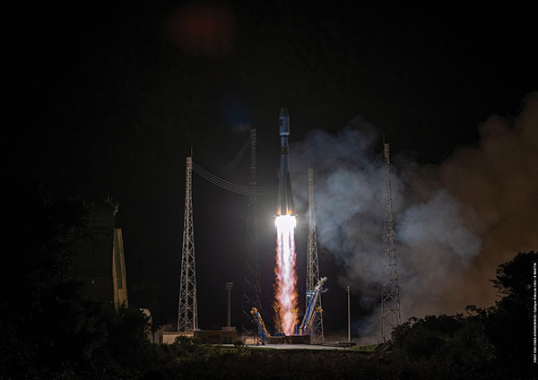
Galileo launch 11 from Europe’s spaceport in French Guyana sent satellites 27 and 28 into orbit. (Photo: ESA/CNES/Arianespace)
News from the European Space Agency (ESA)
Europe’s latest Galileo satellites in space have joined the operational constellation, transmitting navigation signals to three billion users across Earth as well as relaying distress calls to rescuers.
Their entry into service follows a summer test campaign and will result in a measurable increase in positioning accuracy and improved data delivery performance of the overall Galileo system.
Galileo satellites 27-28 were launched at the end of 2021 and underwent in-orbit test review at the end of April. The review was conducted by ESA, satellite manufacturer OHB, and navigation payload maker Surrey Satellite Technology Ltd (SSTL).
Key findings showed both satellites’ payloads are performing extremely well — among the best in the entire constellation — and the satellites entering into service increase the position accuracy and robustness of the overall Galileo system.
A successful system and in-orbit operations review followed, co-chaired by ESA and the EU Agency for the Space Programme (EUSPA), which is in overall charge of commissioning.
Improved navigation message
The two satellites are the first to broadcast an improved navigation message, resulting in three key improvements for Galileo’s public Open Service users:
faster navigation data acquisition, allowing users to establish a first position fix more rapidly
better robustness in challenging environments, such as urban centers
easier access to timing information in the navigation message for users possessing only a rough estimate of timing of the order of 1-2 seconds.
For the testing and broadcasting of this new navigation message, new software for the Navigation Signal Generation Unit was developed by Thales Alenia Space in Italy, SSTL, OHB and ESA, and was uploaded to the two satellites.
During the summer, an extensive test campaign was conducted by ESA to ensure the compatibility of the entire Galileo system at unit, payload, satellite, ground and system levels with the enhanced message. As part of this effort, EUSPA oversaw receiver testing to ensure this compatibility extended to Galileo receivers and chipsets in the market.
These latest launched satellites made ideal test cases for the software and the improved navigation message. Transmission of the upgraded signals from Galileo satellites 27-28 allowed the team to confirm its correct implementation and characterize its long-term performance.
Following a successful Test Review Board, the satellites were brought back into service on Aug. 29
Galileo High Accuracy Service one step closer to initial launch
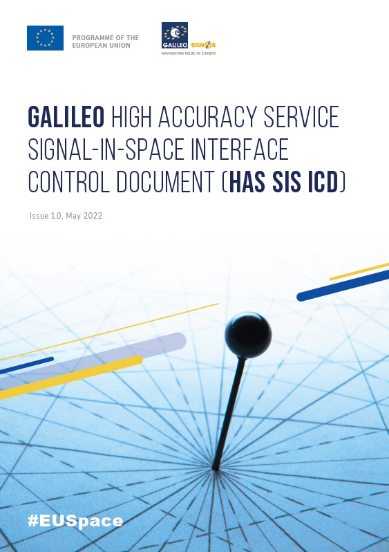
The EU Agency for the Space Programme (EUSPA) has published the first Galileo High Accuracy Service Signal in Space Interface Control Document (HAS SIS ICD). The document can be downloaded here.
The HAS SIS ICD was published by EUSPA together with the European Commission and the European Space Agency (ESA).
By providing free-of-charge, high-accuracy precise point positioning (PPP) corrections through both the Galileo signal (E6-B) and via the internet, the HAS will offer users improved positioning performance with an accuracy of less than two decimeters.
“Galileo will be the first GNSS constellation capable of providing a high-accuracy service directly through the signal in space,” explained Guerric Pont, Galileo Services, EUSPA program manager. “This is unique in that, typically, high-accuracy services are based on accurate satellite and atmospheric data provided from a third party, but not directly from the GNSS.”
According to Pont, high-accuracy services are experiencing a massive boost in interest, thanks in large part to new capabilities of GNSS receivers and the rapid emergence of new applications that require accurate location data.
“Currently, high accuracy is primarily used in such professional applications as surveying, precision agriculture and civil engineering, among others,” he said. “However, new and emerging applications, including autonomous driving, unmanned vehicles, robotics and a range of location-based services, will all welcome high accuracy.”
Pont also notes that, when used in synergy with Copernicus, the Galileo HAS will open up market possibilities and help design new services.
An ongoing process
In 2021, EUSPA, in coordination with the European Commission and ESA, published an Information Note on the Galileo HAS. The note provided an overview of the service’s main characteristics, along with information on such key features as service levels, targeted performance and markets, and a roadmap for implementation.
This was followed by a call for Expression of Interest for High Accuracy Service Testing, which invited external stakeholders to participate in a testing campaign of the Galileo HAS Signal in Space broadcasting. The goal of the campaign was to collect relevant feedback, not only on the HAS SIS ICD structure and implementation at the receiver level, but also on service-related aspects and specifications.
“The Galileo program has been performing a long set of HAS testing activities since 2019, which cumulated in the first-ever HAS signal broadcast in May 2021,” said Javier de Blas, EUSPA Commercial and HAS manager. “Based on the feedback gained during the joint efforts conducted by EUSPA, the European Commission and ESA, with the key support of European aerospace industry during the testing phase, we are now able to publish the first Galileo High Accuracy Service Signal in Space Interface Control Document.”
Following the publication of this HAS SIS ICD, the Galileo Program will continue deployment and service validation of HAS over the next months, in view of an operational declaration of HAS initial service, or HAS Phase 1, by the end of 2022. This will enable development of products in parallel to the gradual entry into full operational service in the next few years.
After a challenging Launch and Early Orbit Phase (LEOP) and testing campaign during the COVID-19 pandemic, Galileo satellite “Nikolina” (GSAT0223) entered service on May 5. The satellite will reinforce the performance and robustness of the Galileo satellite.
GSAT0223 was launched Dec. 5, 2021 with Galileo launch L11 after the usual design, acceptance, validation, launch and early orbit preparation and operations phases.
This was the first Early Orbit Operations phase conducted directly from the operational center in Germany, under the responsibility of EUSPA.
GSAT0223 and its launch companion GSAT0224 (Shriya) are the first pair of the third batch of Galileo First Generation satellites to reach space. GSAT0223 will fill the last empty slot in Galileo’s orbital plane B.
Shriya will soon complete its in-orbit validation and will then join the operational constellation. Ten additional satellites of the same batch are continuing assembly, acceptance and launch preparations.
Galileo Second Generation Batch#1A satellites. (Image: ESA).
Successful European Cooperation
Galileo is Europe’s civil global satellite navigation constellation and a major success, being the world’s most precise satnav system and offering meter-scale accuracy to more than two billion users around the globe.
The signature of the Financial Framework Partnership Agreement (FFPA) on June 22, 2021, further strengthened effective cooperation between the European Commission (EC), the European Union Agency for the Space Program (EUSPA), and the European Space Agency (ESA) — key to successfully achieving a crucial EU Space Program component like Galileo in the current EU Multi Financial Framework (2021–2028).
The EC is the program manager, with EUSPA acting as the exploitation manager and ESA as the system development prime.
Stable Service Performance
Galileo continues to deliver excellent service performance every month in a safe, secure and seamless manner. Delivery of Galileo services is managed by EUSPA, as the Galileo service provider, with industrial partner SpaceOpal, the Galileo service operator prime contractor. The performance of Galileo services is independently monitored by the Galileo Reference Center (GRC) and regularly published on the GNSS Service Center (GSC) web portal at www.gsc-europa.eu — both agencies were developed by GMV. The security of the Galileo System is monitored by the Galileo Security Monitoring Centers (GSMC), operated by EUSPA.
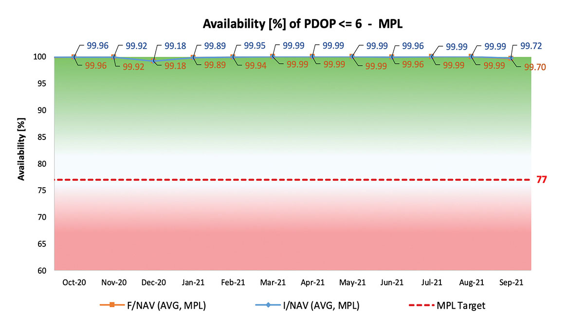
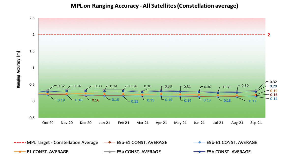
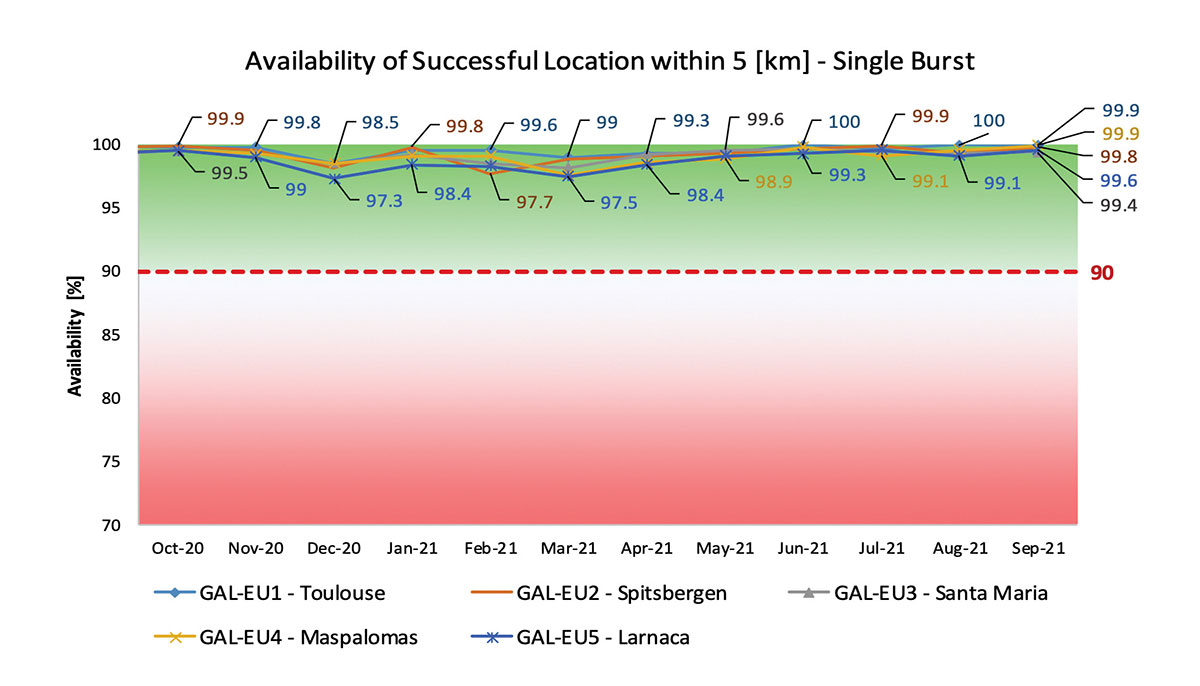
With 22 satellites in service, the open service is already delivering more than 99% availability of PDOP <= 6 worldwide. This, together with the excellent ranging accuracy, suggests that most Galileo dual-frequency users are typically experiencing positioning accuracy in the order of only 2 to 3 meters.
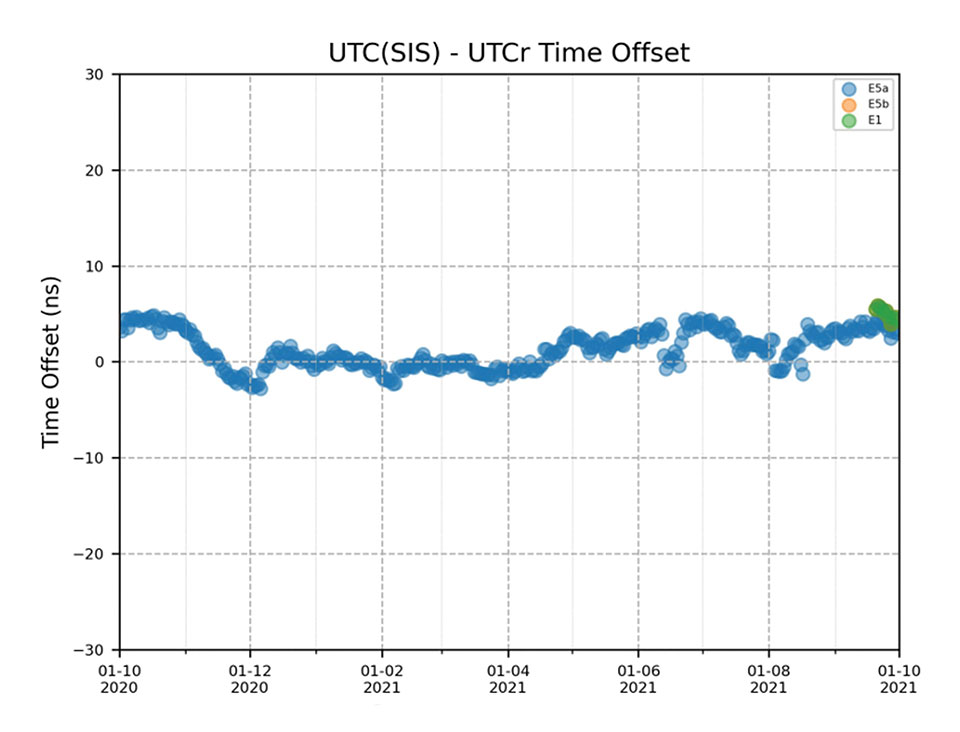
Timing users also continue to receive accurate (in the order of 5 ns) access to Galileo System Time, which they can trace to Universal Coordinated Time (UTC) through the corresponding offset parameters transmitted by the satellites.
The SAR/Galileo service, contributing to COSPAS/SARSAT, continues to deliver both the Forward Link Service (FLS) and the Return Link Service (RLS) with more than 99% availability, allowing users in distress not only to issue an alert and be located within a few minutes, but also be notified that the alert was successfully processed and rescue is on the way. The SAR/Galileo control center is located in Toulouse (France) and operated by CNES under the authority of EUSPA. The excellent performance of the service has been demonstrated both through several rescue exercises and real-life emergencies.
Performance of Galileo positioning services. (Credit: EUSPA)
Performance of Galileo positioning services. (Credit: EUSPA)
Galileo Launch 11
Soyuz launcher VS-26 lifted off from French Guiana with the first pair of Galileo Batch 3 satellites on Dec. 5, 2021, at 01:19 CET. This marks the 11th Galileo launch of operational satellites in 10 years: a decade of hard work by Europe’s Galileo partners and European industry. With these satellites, the robustness of the constellation has increased, guaranteeing a higher level of service.
Thanks to an upgrade of the Ground Control Segment, the Launch and Early Orbit Phase has been for the first time conducted directly from the Galileo Control Center, rather than requiring an external mission control site. This version of the ground segment increases overall reliability and cybersecurity and opens the way to significant expansion of the Galileo constellation, allowing command and control of up to 38 satellites. The development has been performed by an industrial consortium led by GMV, harnessing state-of-the-art technology using the latest solutions on the market.
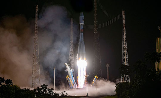
Galileo launch 11 from Europe’s spaceport in French Guyana. (Photo: ESA)
On Route to Full Operational Capability
This year will pave the way toward Full Operational Capability of Galileo services.
Industrial prime contractor OHB Systems has nearly completed production of the additional 10 recurrent satellites belonging to Galileo Batch 3. Six of them are undergoing final acceptance testing at the ESA satellite test center, and the other four are under integration at the satellite prime facilities.
Preparation for Launch 12 has already started, with the satellites’ acceptance for a launch date planned in the first months of 2022, followed by Launch 13 in autumn. This is leading toward completion of the Galileo constellation, providing an increased availability of the Galileo signal in space for both GNSS and search-and-rescue users.
Performance of Galileo timing and search-and-rescue services. (Credit: EUSPA)
Performance of Galileo timing and search-and-rescue services. (Credit: EUSPA)
From 2023 onward, the remaining Batch 3 satellites will be launched with the new Ariane 62 launch vehicle, a variant of Ariane 6 with two strap-on solid boosters. The launcher is undergoing the final stages of development, led by prime contractor ArianeGroup.
The Galileo Ground Mission Segment will undergo a complete technological refresh, including hardware virtualization and porting of several million lines of code, performed by an industrial consortium led by Thales France. A series of improvements will be introduced to increase system resilience, including an extended mode of operation to improve service continuity and robustness.
Cybersecurity monitoring of all the ground assets will be introduced as an overlay to the current ground infrastructure. The upgrade will undergo a rigorous level of qualification testing followed by worldwide deployment in a seamless way in both Galileo control centers, in both Galileo security monitoring centers, and at all remote locations without affecting continuity of service.
The service facilities that contribute to the delivery of Galileo services (the European GNSS Service Center, the Galileo Reference Center, and the SAR data service providers) will also evolve to support not only the transition from Initial Services to Full Operational Capability, but also the early roll-out of service evolutions. In this regard, extensive work is ongoing to deliver an exciting set of improvements, some of which are already in development or testing, to reach the users in the year to come:
Improvements of the I/NAV signal to increase robustness and time-to-first-fix, while assuring full backward compatibility with legacy receivers.
OS Navigation Message Authentication (OS-NMA) to support applications that require trust in the authenticity of the data transmitted by the Galileo satellites (a public observation campaign was launched in November 2021 to engage stakeholders and collect their feedback before moving to the initial service provision).
An initial phase of the High Accuracy Service, delivering corrections in the Galileo E6 signal and over terrestrial network to allow users to perform precise point positioning over Europe; test signals were already transmitted with promising results.
A Search and Rescue Beacon Command Service complementing the SAR Return Link, providing improved capabilities to timely locate beacons under authorized emergency situations (such as the disappearance of Flight MH370 in the Indian Ocean in 2014).
A first implementation of an Emergency Warning Service over Europe, allowing the authorized national emergency-management authorities of the EU Member States to relay alert messages through Galileo signals, which can reach target areas even in case of disrupted terrestrial communications (such as due to floods or earthquakes).
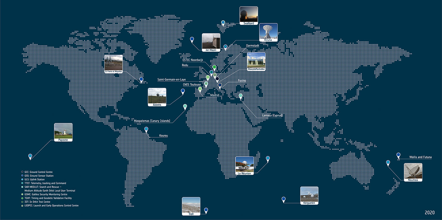
Galileo worldwide ground segment. (Credit: ESA)
Second Generation in the Making
The FFPA will bring Galileo to the next level with the development of the second generation, a further step forward with the use of many innovative technologies to guarantee the system’s unprecedented precision, robustness and flexibility.
In parallel to the completion of the first generation of Galileo, Europe has conducted in recent years preparation activities for the Second Generation (G2). Elaborating on market, user and exploitation needs collected by EUSPA, ESA identified a number of system evolution scenarios, which were discussed among relevant EU stakeholders to select the second-generation mission and services baseline to build the system infrastructure.
The evolution of Galileo capabilities will not only provide better services through advanced technical solutions identified by ESA, but will also ensure continuity of service and backward compatibility for
first-generation legacy users.
Two parallel contracts to develop and manufacture each of the six Galileo Second Generation Batch#1 satellites were kicked off in the first half of 2021 with Thales Alenia Space (Italy) and Airbus Defence & Space (Germany). The new G2 satellites will be constructed on a short time scale, with their first launch via Ariane-62 expected in less than four years, allowing them to commence operations in space as soon as possible. Both contracts have already undergone preliminary design reviews.
Development of the G2 satellites is supported by the Galileo Payload Test Bed, which provides an early proof-of-concept of the advanced G2 payload architecture. These satellites will provide, among others, the following key innovations:
Reconfigurable fully digital navigation payload.
Point-to-point connection between satellites by Inter-Satellite-Link for command and control and ranging functionalities.
Electric propulsion for orbit-raising capabilities.
Advanced jamming and spoofing protection mechanisms to safeguard Galileo signals.
System and Ground Segment definition studies, together with the associated technology pre-developments, have been performed, leading to the definition of the preliminary design and technical requirement baseline for the G2 system, a project involving most of Europe’s space industrial partners.
The G2 In-Orbit Validation Ground Segment and System Test Bed have been defined and relevant procurement procedures are ongoing, with these objectives:
G2 Batch#1 satellites launch and early orbit phase, in-orbit testing and enhanced legacy services provision.
G2 new capabilities in-orbit validation, including prototyping and validation of all the novel technologies that can exploit the full capabilities of the G2 Batch#1 satellites.
Galileo Second Generation Batch#1B satellites. (Image: ESA).
Definition activities for the G2 Initial Orbit Capability (IOC) are progressing well and are expected to converge in the first half of 2022, in order to establish the future roadmap for new G2 services provision in the years to come.
2022 will be a key year for the evolution of Galileo Second Generation activities, through the consolidation of the first batch of G2 satellite design and development activities and the start of development of associated G2G IOV Ground Segment and System Test Beds.
A bright future awaits Galileo, both through the completion of its Final Operational Capability and the start of evolution towards Galileo Second Generation.
Guerric Pont is Galileo Exploitation Program manager for the European Union Agency for the Space Program (EUSPA).
Marco Falcone is Galileo First Generation Project manager for the European Space Agency (ESA).
Miguel Manteiga Bautista is Galileo Second Generation Project manager for the European Space Agency (ESA).
Arianespace will launch eight additional Galileo satellites, confirmed the European Union Agency for the Space Programme (EUSPA).
Arianespace will launch the first two satellites in 2022, leading to the Full Operational Capability of Galileo open service. Then, three successive launches on Ariane 62 in 2023, 2024 and 2025 will finalize the launch of the first generation of Galileo satellites and will increase the constellation resilience.
These will be the 13th to 16th Galileo missions by Arianespace, which has orbited all satellites in the constellation.
With this order, EUSPA takes over the role of placing launch services contracts for Galileo from the European Space Agency (ESA), which has acted so far in the name and on behalf of the European Commission and will continue to be the technical authority for these launches.
The order follows ESA’s order for the launch of four satellites in October 2021, and will complete the deployment of first-generation Galileo satellites.
The launches will take place from the Guiana Space Center, Europe’s Spaceport in Kourou, French Guiana. After a Galileo launch in the first half of this year, carrying satellites from a previous order, a second Soyuz launch this year will orbit the first two satellites from this latest order. The next three missions will orbit two satellites each on Ariane 62.
“I would like to thank ESA and EUSPA, along with the European Commission, for continuing to entrust us with their satellites,” said Stéphane Israël, CEO of Arianespace. “We’re very proud to once again be helping the EU deploy its own global navigation satellite system. This additional order to the service of Galileo once again confirms Arianespace’s assigned mission of ensuring reliable access to space for Europe.”
Each of the eight satellites under this order, built by OHB System AG in Bremen, Germany, will weigh less than 730 kg. They will join the 28 Galileo satellites already deployed to date, as well as the two to be orbited in early 2022 from the Guiana Space Center by Arianespace.
Project will boost the positioning performance and real-time operability of the Galileo system.
The European Space Agency (ESA) has selected Thales Alenia Space to support the implementation and experimentation of the navigation algorithms that will be used in the Galileo Second Generation program. Under the contract, Thales will develop the Advanced Orbit Determination and Time Synchronisation (ODTS) Algorithms Test Platform (A-OATP).
Thales Alenia Space, a joint venture between Thales (67%) and Leonardo (33%), is the prime contractor for Galileo First Generation’s Ground Mission Segment,.
ESA granted the contract on behalf of the European Commission in the Horizon 2020 Satellite Navigation Program (HSNAV).
In a previous contract, Thales Alenia Space was chosen to provide six satellites and initiate the B2 phase of development and implementation of its ground segment for the Galileo Second Generation constellation.
Using its long-standing legacy regarding navigation algorithms in addition to an innovative approach, Thales Alenia Space will develop and test a new Advanced ODTS solution. The new orbitography algorithms will allow a significant improvement in positioning performance and real-time operability of the Galileo system. It will exploit the accuracy of the GNSS orbit and clock estimation, with a solution optimized for the real-time generation of Galileo navigation messages, and take full advantage of the evolution of satellites and ground stations considered in the Galileo Second Generation.
With this new contract, Thales Alenia Space applies on a deep experience concerning orbitography algorithms as well as knowledge of the Galileo system to strengthen its position as a major actor for the development of the new generation of this satellite system, the company stated in a press release.
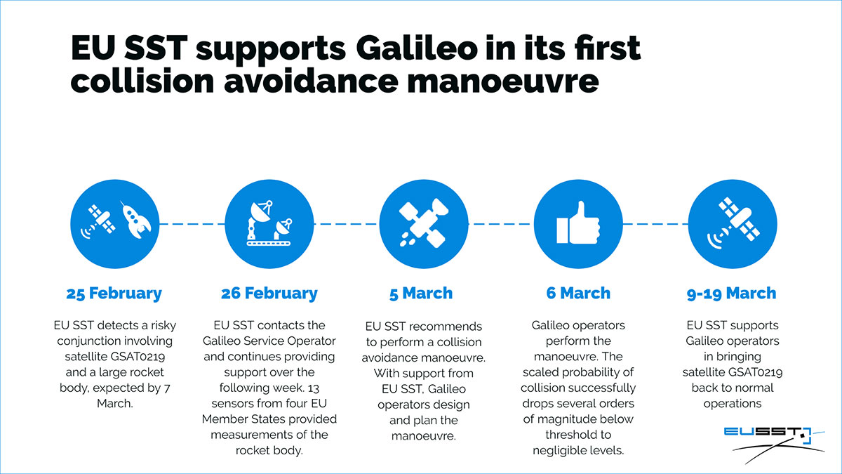
On Feb. 25, the Galileo Service Operator (GSOp) received from EUSST a collision risk alert between GSAT0219 and an inert Ariane 4 upper stage launched in 1989. Following the warning, GSOp closely monitored the risk, in close cooperation with EUSST that was refining its predictions.
In line with operational procedures, GSOp informed the GSA of the situation. In a joint effort with the European Commission, the GSA managed the follow-up activities. The effective cooperation between EUSST and the GSA/GSOp was instrumental to the success of the mission and bears testimony to the need for efficient cooperation between different organizations in the space sector.
Maneuver Authorized
Following refinement of the Ariane 4 orbit, the risk of collision was still unacceptably high. After assessment of different strategies and associated risks on the service provision, the GSA authorized the execution of an avoidance maneuver.
The satellite was taken out of service on March 5, and users were informed via NAGU #2021009. The collision avoidance maneuver was performed shortly thereafter, by temporarily relocating the satellite away from its nominal position.
Satellite GSAT0219 was reintroduced into service on March 19 after the completion of two station-keeping maneuvers to reposition it into its nominal operational orbit. A second NAGU advised users that the satellite was once again available.
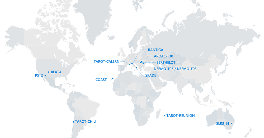
Map of sensors contributing to the event. (Image: EUSST)
The end of 2020 marked a milestone for the Galileo First Generation, as the program chalked up its 500th European Space Agency (ESA) Engineering Board.
For more than 12 years, ESA and industry engineers from all relevant disciplines — system, satellite, ground, signal, radio navigation, RAMS (reliability, availability, maintainability and safety), security and infrastructure — have put their best skills at the disposal of the board.
The board is a forum where technical experts regularly meet to maintain, review and update the Galileo Project technical baseline, known as the System Technical Requirements Baseline (STRB). The STRB drives the implementation of the Galileo System and its infrastructure, the space and ground segments, along with associated interfaces and operations.
The G1 system technical specification under ESA adds up to more than 22,000 separate requirements. These requirements are both unclassified and classified, with considerable interdependencies which all that need to be controlled in configuration.
The Galileo G1 Engineering Board is chaired by ESA in accordance with its role as Galileo System Design Authority, assigned to it by the European Commission.
Since the building of the first G1 Engineering Board in 2008, 26 Galileo satellites have been built, tested and flown. The Galileo system’s globe-spanning ground system has also been put in place and made operational. The board continues to be a crucial enabler for further robustness improvements and new service evolutions.
A further 12 Batch 3 satellites are set to join the constellation in the coming decade. These satellites are being finalized at OHB Systems in Bremen, Germany, and then tested at ESA’s ESTEC Test Centre in the Netherlands.
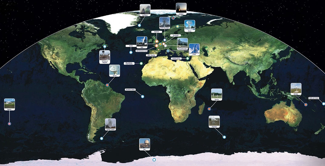
The worldwide Galileo ground segment includes two control centers (Italy and Germany) as well as various tracking, uplink and sensor stations and monitoring and test centers. (Image: ESA)
Galileo began initial operations in December 2016 and today serves more than 1.5 billion smartphones and devices.
The G1 Engineering Board meetings will continue, complemented with Engineering Boards for the new Galileo Second Generation (G2 satellites are planned for later this decade), which are already well underway.
By Fabio Dovis, A. Minetto, A. Nardin, Politecnico di Torino Department of Electronics and Telecommunications, E. Falletti, D. Margaria, M. Nicola, M. Vannucchi, LINKS foundation
Following the issue by the Galileo Service Center of the Notice Advisory to Galileo Users (NAGU) reporting Service Outage for all the Galileo satellites, as curious Galileo users our team of researchers of the NavSAS group started an independent investigation of the received signals in space (SISs).
In fact, we observed that a commercial ublox EVK-M8T receiver, forced to use Galileo-only satellites, provided a “no-fix” indication. Three Galileo-enabled smartphones, the Xiaomi MI 8, Huawei P 10 and Samsung Galaxy S8, which use assistance from the cellular network, were also not providing a Galileo-based position solution, considering the Galileo satellites as “not usable.”
However, the investigation started exploiting our in-house developed software receiver NGene, that was used in the past for similar monitoring of the GNSS signals, for example at the time of the transmission of the first IOV Galileo satellites in 2012, and the transmission of anomalous GPS signals from SVN49 in 2009. Monitoring the Galileo SISs, which were usable until the day before, we found that they were still correctly trackable, with normal power levels and Doppler profiles within feasible limits.
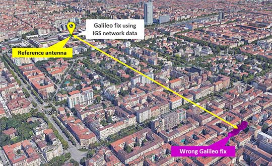
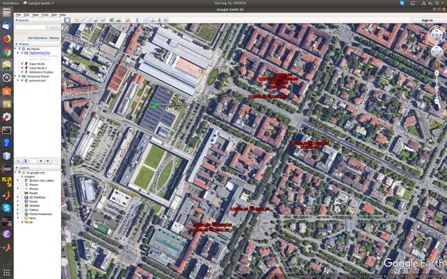
At the time of the first analysis, seven satellites were visible in the sky over Torino, Italy. Figure 1 reports a screenshot of the positions computed by means of NGene between 07:14:54 and 07:24:54 UTC on July 15, plotted on Google Earth. The position estimated using the Galileo-only satellite or hybrid GPS-Galileo solutions (red dots) showed errors on the order of 500 meters or even more. The georeferenced antenna position is depicted by the green pin.
Figure 1. Misplaced Galileo and GPS+Galileo solutions. (Screenshot: Politecnico di Torino and LINKS Foundation)
The monitoring of the status flags taken from the Galileo E1B I/NAV message showed that the SIS was marked as “healthy” for all the visible PRNs apart the number 14, which is known to be “not usable” for a long time. The Signal in Space Accuracy Index (SISA) was set to 109, which is an acceptable prediction of the minimum standard deviation of an overbound of the SIS error.
According to the Galileo Open Service, Service Definition Document (OS SDD, issued 1.1, May 2019), a SIS “Healthy” means that the SIS is expected to meet the Minimum Performance Level and “a navigation solution obtained with Galileo SIS is expected to meet the Minimum Performance Levels reported in the Galileo OS SDD only if receivers comply with the assumptions reported in Section 2.4, including the use of navigation parameters within their broadcast period.”
In fact, the document specifies that “The navigation solution is expected to meet the Minimum Performance Levels only if receivers do not use navigation parameters beyond their broadcast period. The maximum nominal broadcast period of a healthy navigation message data set is currently 4 hours.”
The check of the nominal broadcast period was bypassed in our software receiver, which is indented as a research tool and not a commercial product as the one mentioned above, so that we were still able to obtain a GPS + Galileo PVT solution, since this check looked to be the only discrimination factor to validate and thus exclude the computed solution.
On July 17, the SISA flag was changed to 255: according to the OS SDD, the accuracy status was “No Accuracy Prediction Available (NAPA).” This means that the status of the broadcast SIS must be intended as “Marginal.” In this condition the EVK-M8T restarted to provide Galileo-based fixes, while the Xiaomi Mi8 Pro smartphone still excluded the Galileo satellites from its PVT fix.
The analysis of the decoded Galileo navigation message led to the conclusion that ephemerides and clock correction data were last updated around 19:00 UTC of 1July 16. For example, PRN 3 and 15 changed Issue Of Data (IOD) from 958 to 17 at Galileo Signal Time TOW 241855, which corresponds to 19:01:25.
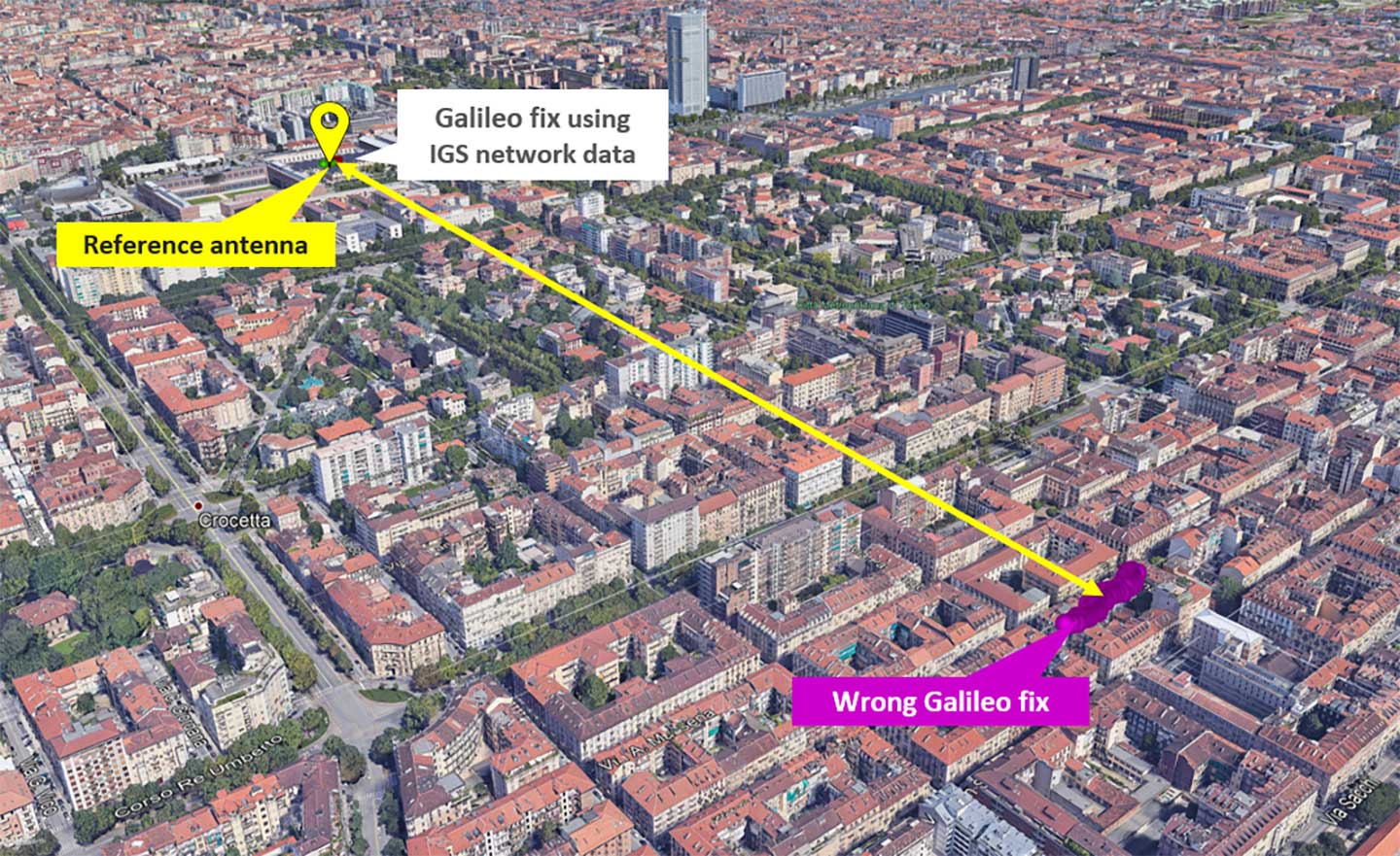
As a final check, we used external ephemerides to process the Galileo signals during the “system outage.” Figure 2 and Figure 3 show different navigation solutions obtained by processing a data collection taken on July 12 at 10.00 UTC (12.00 Local time). The purple dots indicate few fixes obtained by demodulating the navigation message transmitted by the Galileo satellites and show a remarkable bias with regard to the reference antenna location.
Figure 2. Comparison of Galileo-only solutions using Navigation message ephemeris data and IGS ephemeris. (Image: Politecnico di Torino and LINKS Foundation)Figure 3. Zoom on the Galileo-only positions obtained by using IGS data.(Image: Politecnico di Torino and LINKS Foundation)
In Figure 3, the green dots are the navigation solution obtained correcting the satellites positions according to precise orbits data and clock drift provided by the IGS network. The fix is a simple code based Least Mean Square solution without smoothing of the pseudoranges.
The two results were obtained by processing the same satellites signals, thus proving that their quality was still sufficient to get an acceptable positioning solution during the Galileo service outage period. This brought us to the conclusion that, during the outage, only the ephemerides updates were affected by problems, while the other SIS components appeared sound and usable.
The Galileo signal outage, ongoing since Thursday, July 11, has been attributed to a problem with the system’s ground infrastructure, according to an announcement by the European GNSS Agency (GSA). “Experts are working to restore the situation as soon as possible,” states the GSA. “An Anomaly Review Board has been immediately set up to analyze the exact root cause and to implement recovery actions.”
No update has appeared at this time as to when service will resume.
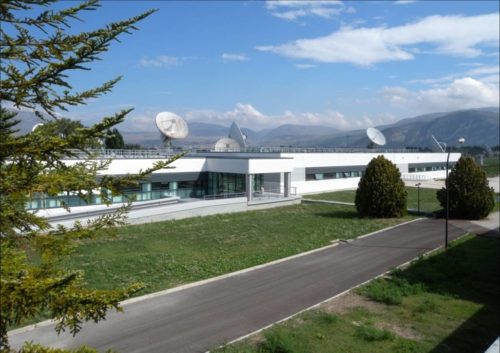
[Photo: Galileo’s Ground Mission Segment in the Fucino Control Centre in Italy oversees Galileo navigation services and satellite payload operations. Photo: Telespazio.]
The announcement points out that Galileo is currently in its initial services phase, wherein its signals are available for use in combination with other GNSS and do not provide a complete solution in and of themselves. This status is expressly designed to allow for “the detection of technical issues before the system becomes fully operational,” according to the GSA.
Indeed, experiments undertaken with Galileo-capable smartphones found that these devices excluded Galileo participation in their position solution. This is likely true of commercial receivers as well, which employ sophisticated signal checks as well as following system notice advisories, which have been issued in this case.
“For each constellation, there is a defined maximum age of ephemeris that is considered valid,” explained Sandy Kennedy, vice president, innovation at NovAtel. “Once an ephemeris is too old, our receiver will deem it invalid. Measurements made to satellites without a valid ephemeris are not allowed to contribute to the PVT solution. We noticed the missing Galileo ephemeris within 3 hours of the broadcast stopping. It wasn’t the NAGU that alerted us to the problem.”
The company posted a bulletin to its website on Friday afternoon, July 12, stating: “During this time [without ephemeris], NovAtel receivers will continue to track Galileo signals, but without a valid ephemeris, the signals are not included in the position solution. . . . Once the Galileo service returns to normal and transmits ephemeris information, NovAtel receivers will revert to normal operation.”
The experiments mentioned above were conducted by the Navigation Signal Analysis and Simulation (NavSAS) Group at Fondazione LINKS (formerly the Istituto Superiore Mario Boella) and the Politecnico di Torino. In their account they state that, using a software receiver that tracked the Galileo signals in space (SISs), “the position solution computed using both the GPS and Galileo constellation is affected by errors on the order of 500 meters or even more.”
In a detailed technical analysis, the NavSAS Group found three other curious and unexpected aspects of the situation, all explored and illustrated at the Group’s posting.
The upgraded McMurdo FastFind 220 and Kannad SafeLink Solo Personal Location Beacons. (Photo: Orolia)
Orolia’s McMurdo FastFind 220 and Kannad SafeLink Solo personal location beacons (PLB) now operate with the Galileo GNSS system.
The PLBs are the first of a series of new solutions coming from the European Union-funded Helios project, led by Orolia, which has been set up to leverage the power of the new satellite system.
With Galileo, the upgraded multi-constellation PLB receivers offer increased global coverage and support accelerated rescue missions. Location detection is enhanced and can be more precise as the PBLs receive coordinates from the Galileo satellite network in addition to GPS. Signals can even be detected in high-sided locations, such as canyons.
“We are thrilled to be launching our upgraded PLBs in the European and U.S. markets,” said Chris Loizou, vice president of maritime at Orolia. “The combination of both Galileo and GPS GNSS capability means that our customers will benefit from coverage that spans from the North to the South Pole. We work tirelessly to push the boundaries of product innovation and, ultimately, to give people the best chance of being rescued in an emergency situation.”
The McMurdo FastFind and Kannad SafeLink PLBs are part of Orolia’s comprehensive search-and-rescue ecosystem and join the McMurdo SmartFind G8 and Kannad SafePro series EPIRBs as Galileo-capable rescue beacons.