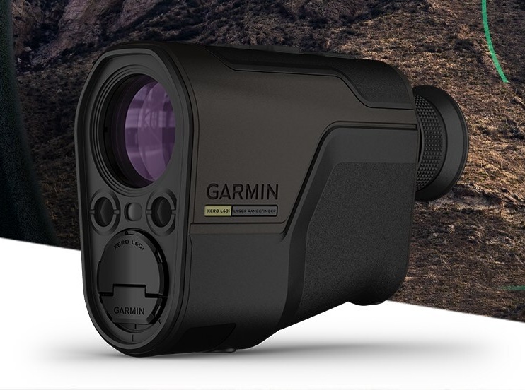
Garmin has released the Xero L60i, a GNSS-enabled rangefinding monocular. The rangefinder’s optics providea sharp, bright view through augmented reality technology that overlays graphics in full color, including distance, maps and navigation and more — all while ranging targets out to 3600 meters through 7X magnification.
Integrated navigation features include Laser Locate, Sensor Locate and Visual Recall, giving wildlife enthusiasts, researchers, search-and-rescue teams tools they can depend on, the company said.
Xero L60i features
Digital mapping. View current and ranged locations marked on topographic mapping and use the Xero L60i to navigate to them.
Smart Integration. Waypoints can be shared to the Garmin Explore App on a compatible smartphone, then shared to a compatible Garmin handheld or wearable device using the Garmin Share functionality.
Laser Locate. Leverage the range taken, along with compass heading and GPS coordinates, to project a waypoint on the display, then navigate to the waypoint through directional cues.
Sensor Locate. When the desired object is too far to range, built-in GPS, compass, inclinometer and mapping can calculate and project a waypoint of the intended target, allowing estimated ranges to targets several miles away.
Visual Recall. When moving to a new vantage point after ranging, on-screen cues steer the visual field back to a previously marked waypoint.
The rangefinder features fully multicoated, low-dispersion glass, which provides sharp optics with a flat field of view, accurate color fidelity, and superior light transmission. During dawn or dusk use, an ambient light sensor automatically controls display brightness, ensuring the visual scene remains clear.
Range animals to 2,775 meters and trees to 3,600. In optimal low-light conditions, the Xero L60i makes it possible to reach as far as 7,000 meters to retro reflective objects while achieving accuracy of +/- .25 meters under 1,000 meters and +/- 1 meter out to maximum laser-ranged distances.
Read a roundup of recent products in the GNSS and inertial positioning industry from the May 2025 issue of GPS World magazine.
SURVEYING
Integrated Navigation Solution Ideal for inspection and survey applications
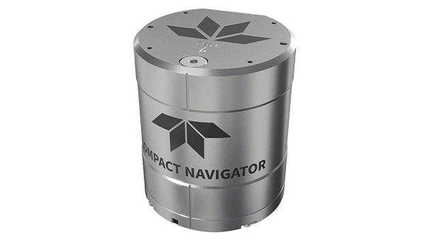
Photo: Teledyne
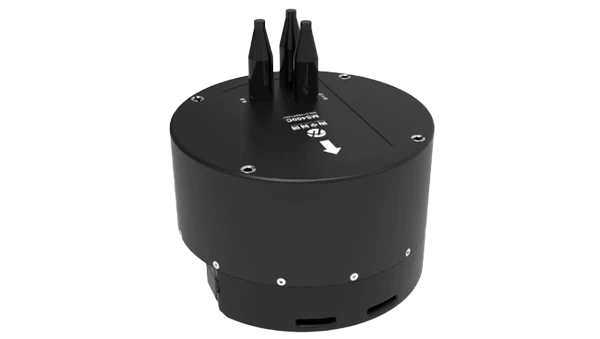
Teledyne Compact Navigator is an ultra-compact autonomous integrated navigation system engineered for subsea and surface vehicles. It is ideal for small vehicles, enabling inspection and survey operations on compact platforms. The system is offered in two depth-rated models, one capable of operating at 4,000 m and another at 300 m. The Compact Navigator consumes less than 7 watts of power, extending mission duration by conserving energy. The system operates fully autonomously, eliminating the need for external aiding or operator intervention. Advanced phased array Doppler Velocity Log technology enhances performance while allowing the device to be mounted on an autonomous underwater vehicle or ship hull.
The Compact Navigator supports a broad range of applications, including autonomus underwater vehicles, shallow water surface navigation, operations in GNSS-denied environments and dynamic positioning for surface vehicles. The system provides true North-seeking gyrocompass-grade performance, and its web-based user interface supports integration, operation and troubleshooting. It is factory-calibrated and offers a battery backup option for reliability in demanding conditions. The system operates independently of satellite signals, making it resistant to jamming or signal loss. This capability is significant for shallow water navigation, where GNSS-based systems may be unreliable.
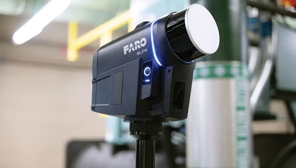
3D Reality Capture Solution Can be used across various industries
Photo: Faro
FARO Blink, a new 3D reality capture solution, is designed to make collecting and utilizing 3D data more accessible and efficient. It centers on software-driven technology integrating advanced visualization and automated workflows through the FARO Sphere XG Digital Reality Platform. This integration aims to simplify operations and deliver faster, more actionable insights for users across various industries.
FARO Blink is tailored for professionals in fields such as surveying and construction. It offers high-quality visualization and can streamline workflows, allowing teams to efficiently capture, view and share 3D data, thereby enhancing project progress and collaboration.
The MS400C is a fully integrated multibeam echosounder designed for uncrewed surface vessels. The new system combines sonar processing, inertial navigation, GNSS positioning and sound velocity sensing into a single unit.
The MS400C seeks to address deployment challenges faced by USV operators during hydrographic surveying. Its compact, lightweight design allows direct mounting on small platforms. Installation involves connecting a few cables to the IPC and power supply and to the primary and secondary GNSS antennas. With preconfigured spatial relationships, operators can deploy and start surveying quickly, reducing configuration errors and ensuring consistent data quality.
Equipped with Auto Survey functionality, the system calibrates parameters based on water conditions, which streamlines pre-survey procedures. Real-time roll compensation and attitude data from the internal measurement unit, combined with sound velocity profiling, ensure high-fidelity depth measurements, even in dynamic conditions. Designed for autonomous and remotely operated survey platforms, the MS400C supports data collection in confined waterways.
The SurveyPod RTK/PPK GNSS system is built for professionals in surveying, agriculture, mining and construction. The system integrates GPS, GLONASS, Galileo and BeiDou signals for improved satellite visibility and accuracy, even in harsh environments.
Powered by a CORS Network, SurveyPod offers real-time, centimeter-level positioning ideal for high-precision applications. The device supports tilt compensation for reliable data collection at angles and boasts up to 16 hours of battery life, making it ideal for extended field operations. With this launch, Nibrus Technologies is expanding its survey equipment portfolio, offering a Made-in-India GNSS solution to the global market.
This MEMS-based north-seeking inertial measurement unit (IMU) operates independently of GNSS. It can achieve a heading accuracy greater than 1° secant latitude without GNSS assistance. When integrated with GNSS and SBG Systems’ navigation algorithms, it can achieve INS heading accuracy greater than 0.01°.
Measuring 52 x 52 x 36 mm and weighing less than 150 g, it consumes only 2 watts of power. It offers long-term reliability in demanding conditions, and its ITAR-free status allows unrestricted global deployment. SBG Systems also has developed a new pure north-finding algorithm capable of rapid initialization in both static and dynamic conditions within one minute, as well as an advanced GNSS/INS fusion algorithm that delivers exceptional single-antenna heading accuracy even in low-dynamic environments.
The IMU is particularly suited for subsea applications, including remotely operated vehicles and autonomous underwater vehicles, as well as geospatial and marine surveying tasks requiring precise single antenna heading accuracy.
The first off-the-shelf solutions are expected to be available by early 2026. SBG Systems
Post-Processing Software With upgraded features
Photo: SBG Systems
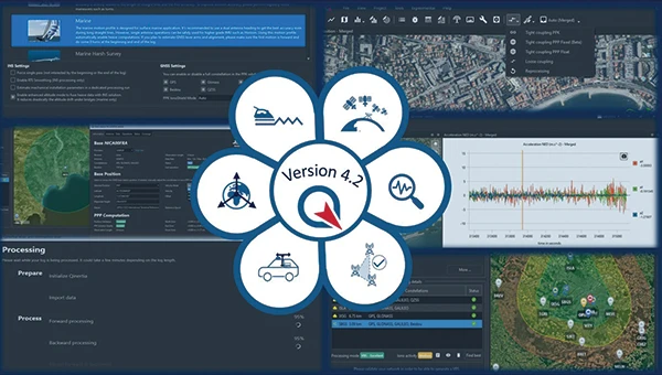
Qinertia 4.2 is an updated version of SBG Systems’ post-processing software for GNSS and INS data. One of the notable additions is the beta version of Precise Point Positioning Fixed Ambiguity, which offers centimeter-level accuracy processing without the need for a base station. The update also includes a new RTS smoothing option, the Trajectory Smoother, which enhances INS processing by removing artifacts while maintaining precision. Another feature is the standalone Lever Arm Estimation Tool, now available as a separate application with a simplified interface. The Advanced Virtual Base Station Network Creation has been enhanced with improved base station quality indicators to increase reliability.
It is compatible with the New Ellipse series and supports Teledyne Intrepid INS. The software now offers faster processing speeds, enhanced geodesy functionalities such as base station velocity analysis, and updated tools for assessing processing quality through new status plots. It also supports the latest firmware versions of Ekinox, Apogee, Navsight and Quanta systems. SBG Systems
MACHINE CONTROL
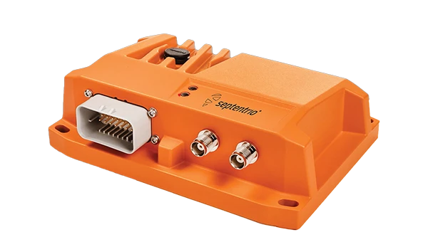
GNSS Receiver and INS System For machine guidance
Photo: Septentrio
The AsteRx RB3 GNSS receiver and the AsteRx RBi3 GNSS/INS system are designed to operate in extreme environments. They feature IP69K-rated housings and components that have undergone ISO-standard testing.
The technology offers durability under heavy shocks, vibrations and challenging environmental conditions, making it suitable for demanding applications such as construction, mining and port automation.
The AsteRx RB3 and RBi3 utilize multi-frequency GNSS technology to deliver precise, centimeter-level positioning even in environments where GNSS signals are typically difficult to maintain. The receivers can be mounted externally on heavy machinery or integrated into chassis systems, offering flexibility in placement and simplifying installation.
The AsteRx RBi3 incorporates FUSE+ technology, which combines a high-performance GNSS engine with an industrial-grade inertial sensor. This integration provides accurate orientation data, such as heading, pitch and roll, alongside reliable positioning. In dual-antenna configurations, the receivers deliver sub-degree GNSS heading accuracy immediately upon initialization. The AsteRx RB3 and RBi3 are ideal for machine guidance in industries requiring rugged equipment to maintain precision under extreme conditions.
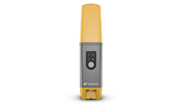
Handheld Reality Capture Solution For maximum mobility
Photo: Topcon Positioning
Designed for mass data solutions, the CR-H1 utilizes PIX4Dcatch, a specialized application with integrated lidar that runs on iPhone devices. It collects images and employs photogrammetry to create detailed, full-color 3D point clouds. The iPhone connects to Topcon’s HiPer CR receiver, enabling the application to collect georeferenced images. The receiver and iPhone are mounted on a specialized handle designed and manufactured by Topcon so that users can capture point clouds without a tripod.
The CR-H1 can be used for utilities and subsurface mapping, construction verification and earthworks, civil engineering and site verification, land surveying and forensics and 3D data capture. Topnet Live subscriptions are available for the CR-H1, providing real-time GNSS corrections that deliver higher-quality point clouds.
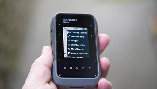
Handheld GPS Device Can provide up to 200 hours of GPS navigation on a single charge
Photo: Garmin
The Garmin eTrex Solar is a handheld GPS device with a built-in solar charging feature. This feature allows for potentially unlimited battery life in optimal sunlight conditions. Even without direct solar input, the device can provide up to 200 hours of GPS navigation on a single charge, making it suitable for extended trips with limited access to power.
The device supports GPS, GLONASS, Galileo, QZSS, IRNSS and Beidou. It features a rugged design, an IPX7 water resistance rating, and a compact, lightweight body that can be attached to a backpack or worn around the neck. Users can import GPX files and navigate to waypoints, courses and geocaches. It also includes a three-axis compass and can store up to a thousand waypoints, 50 courses and 200 activities.
Users can connect the eTrex Solar to their smartphones through the Garmin Explore app, which enables additional features such as geocaching details, weather updates, software updates, trip planning, and cloud storage syncing.
New Product Offerings Now featuring marine GNSS antennas
Photo: Geo-matching
Geo-matching has expanded its product database to include GNSS antennas. The initial marine GNSS antennas featured in this new category are the VP6300 from Calian GNSS, formerly Tallysman, and the AV34 from Trimble.
Geo-matching features detailed information on more than 1,300 products across 63 categories for surveying, navigation and machine guidance. The website is designed to guide users through complex product specifications, offering access to brochures, case studies, product videos and professional reviews. Among the many categories available on Geo-matching.com are hydrographic processing software, GNSS receivers, GIS software, inertial navigation systems, total stations, UAVs, sidescan sonars, imaging sonar and more. The platform encourages users to browse its extensive catalog, upload new products, leave reviews and register their companies to add products to the database.
Mapping UAV With a new “Smart Return-to-Home” feature
Photo: Flyability
Flyability has introduced a “Smart Return-to-Home” (RTH) feature for its Elios 3 UAV, designed to enhance its autonomous capabilities. This feature allows the UAV to return to its take-off point using the shortest available path while avoiding obstacles in real time.
During flight, Smart RTH monitors battery levels through a new flight management gauge, notifying the pilot when it is time to return. The feature is activated via Flyability’s Cockpit flight app, and pilots can take manual control at any point. By automating the return process, the system helps pilots focus on inspections without concerns about battery management or navigation in complex environments. Smart RTH uses lidar scans to generate a flight plan that the UAV executes independently.
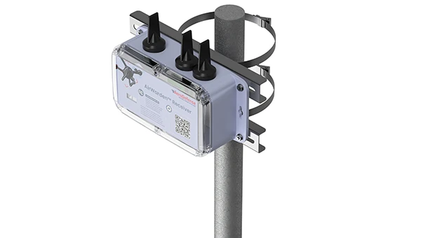
The AirWarden Remote ID Receiver detects and decodes Remote ID signals broadcast by UAVs. It is designed for organizations and authorities that need to monitor UAV activity for safety, security and compliance with regulations.
It decodes the information transmitted by UAVs in accordance with FAA and other regulatory standards. The data it captures includes the UAV’s identification number, its precise location (latitude, longitude and altitude), the takeoff location, operator location if available, timestamps, and other relevant metadata.
The AirWarden can be deployed as a standalone unit or integrated into larger security and monitoring systems. Users interact with the system through a web-based or software interface that facilitates live monitoring, alert management, and data analysis.
Additionally, the AirWarden can integrate seamlessly with other security infrastructure, such as video surveillance and access control systems. This integration seeks to improve how security teams automate responses and coordinate actions when unauthorized or suspicious drone operations are identified.
GPS World is a business-to-business magazine, and most of our readers are engineers, surveyors and other professionals specializing in geospatial technologies. In general, we do not cover consumer applications. Nevertheless, it is important to remember that, while GPS was designed and built, and is managed, by the U.S. military (from 1973 to 2020 by the U.S. Air Force, since then by the U.S. Space Force), more than 99.9% of its users are not members of the U.S. military, nor surveyors, but consumers. They benefit from GPS — and the three other GNSS, namely Russia’s GLONASS, China’s BeiDou and Europe’s Galileo — in many ways and are unaware of most of them, such as the fact that GNSS receivers provide essential timing for radio and television broadcasts, cellphone communications and financial transactions.
The vast majority of consumers access GNSS via their smartphones. We are all familiar with the myriad smartphone applications that rely on GNSS for positioning and navigation — from Google Maps and Apple Maps to Waze and social media platforms such as Instagram. Additionally, weather apps, such as the Apple Weather app, and parking apps utilize GNSS to enhance user experience and functionality. Nearly all smartphones today use at least three of the GNSS constellations — GPS, GLONASS and Galileo — and some use all four. (The use of BeiDou in the United States is a controversial topic that we will explore soon.)
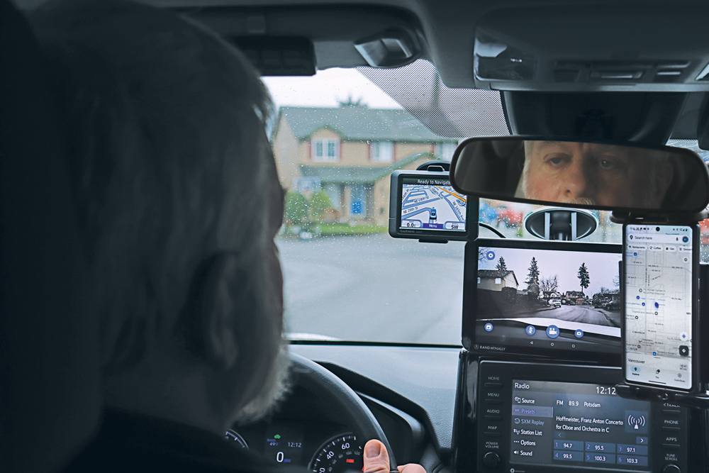
For most people, smartphones have replaced such previously separate electronic devices as calculators, digital cameras and car navigators. (A freestanding GNSS-based car navigation device is still useful, however, when you travel in areas with spotty or nonexistent cell phone coverage, because it relies on maps stored on the device, so it does not require an Internet connection. That is why I still carry a nearly 20-year-old Garmin nüvi in my car.)
For a few years, there were even handheld televisions. (My 1989 Casio TV-400 LCD Pocket Color handheld VHF-UHF TV has a 4 cm x 3 cm LCD screen. It is analog, however, so it stopped working when U.S. television broadcasts switched to digital in 2009.) Now, many people watch news, shows and movies on their phones.
Nevertheless, there are still many freestanding GNSS-based devices. For example:
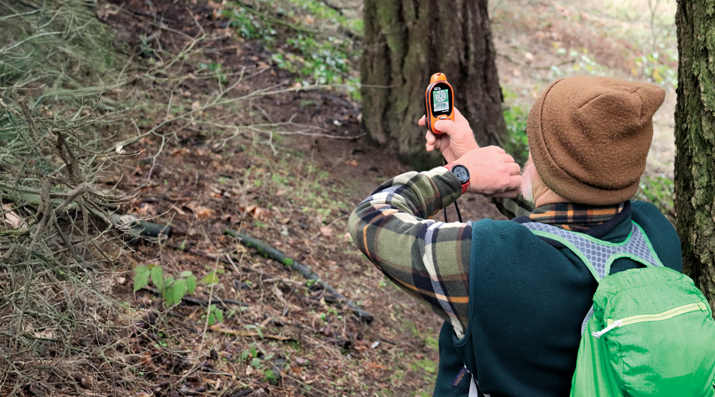
Handheld receivers for hikers and boaters that display your position and heading on topographic maps or nautical charts, as well as such information as elevation, speed, distance to your destination, number of GNSS satellites in view, tides, and sunset and sunrise times.
Cyclometers that show bicyclists their speed, pace and position on a map.
Fitness trackers and smartwatches that track your exercise, sleep, heart rate and biometric data.
Tracking devices that monitor the movements of people, such as children and Alzheimer’s patients, and help recover stolen vehicles and boats.
Additionally, many digital cameras have GNSS receivers that insert the location of each photo into their metadata.
Since I began working in this industry 25 years ago, I have always detested the term “GPS tracker” because it reinforces the already widely held misperception that a GPS receiver somehow “tracks” its user. As most readers of this magazine know, GPS receivers only display and/or store location data for the user, without sharing it with anyone else, let alone broadcasting it. Tracking something requires coupling a GPS receiver with a way to transmit the location data — typically, using a cellphone connection. Plus, nowadays, the word GPS should in most cases be replaced with GNSS. Therefore, I am always careful to say or write “GNSS-based devices.”
What follows highlights three very different GNSS applications in consumer devices:
Handheld receivers and smartwatches by Garmin for outdoor recreation and fitness.
GNSS-based tracking of vulnerable people.
A smartphone application from Google to monitor jamming and spoofing.
— Matteo Luccio, Editor-in-Chief
A nearly 20-year-old Garmin nüvi still provides the author navigation in areas without cellphone reception. (Photo: Matteo Luccio)
Handheld GNSS Receivers
Garmin, founded in 1989, is the 800-pound gorilla in the consumer GNSS market. The company’s annual revenue of more than $5 billion is comparable to the nearly $4 billion annual revenue of Trimble, founded in 1978, which is the 800-pound gorilla in industrial GNSS markets.
Garmin sells a vast array of handheld receivers, smartwatches and other devices for outdoor recreation and fitness, as well as GNSS receivers for general aviation and marine navigation.
In remote areas with scant or no cellphone reception, Garmin’s GNSS receivers offer users substantially more reliable satellite reception and greater positioning accuracy than smartphones. That is for two reasons. First, because a Garmin receiver can host a larger GNSS antenna than a smartphone, which contains several antennas. Second, because it is mostly dedicated to the positioning and navigation mission — unlike the many missions crammed into a smartphone.
Garmin’s multi-constellation and multi-band GNSS handheld receivers come with preloaded topographical maps optimized for outdoor activities, with terrain contours, summits, coastlines and more.
Garmin’s latest line of handheld GNSS navigators — the Montana 710i and Montana 760i — feature built-in inReach technology, which allows users to stay in touch when venturing beyond cell service using reliable satellite communication. Users can utilize two-way text messaging and location tracking via the global Iridium satellite network. In the event of an emergency, users can send an interactive SOS message to Garmin Response, an international emergency assistance coordination center that is staffed 24/7/365.
These devices are ideal for a variety of outdoor activities, including hiking, mountain biking, off-road riding and more. They are also compatible with multiple mounting options to adapt for use on ATVs, boats, cars, motorcycles, RVs and other vehicles.
Garmin Smartwatches
Garmin smartwatches have established themselves as leaders in the fitness and outdoor adventure market. Whether running, cycling, swimming or golfing, Garmin smartwatches provide users with many activity-specific features and metrics.
These watches feature advanced heart rate monitors and pulse oximeters for health monitoring. The company’s latest line of smartwatches come with a Body Battery feature that continuously analyzes combinations of the user’s heart rate, heart rate variability and movement data. The goal of this analysis is to identify meaningful physiological states and to describe the impact they have on the body’s energy levels. At a high level, this means documenting whether users are awake or asleep and when they are physically active, as well as tracking stress levels during periods of inactivity, according to Garmin.
Garmin smartwatches also feature additional sensors to improve location data. They include an altimeter sensor that helps track elevation changes and an accelerometer that detects movement. The latter is used for such tasks as step counting, sleep tracking and other activity measurements.
Garmin watches use multi-constellation (GPS, GLONASS, BeiDou and Galileo) GNSS receivers that enable accurate distance, pace and route mapping during outdoor activities, even in challenging environments.
— Jesse Khalil, Associate Editor
Tracking Family Members and Pets
The Satellai Collar features a lightweight tracker attached to a padded harness designed to avoid snags, discomfort or mobility restrictions. (Photo: Satellai)
GNSS technology enables consumers to track those most important to them – their family, friends and even their pets.
Companies such as u-blox offer devices that can be worn by the elderly and children to enable their caregivers or parents to track them. The devices help locate individuals through ›GNSS receivers (using all four GNSS constellations); Bluetooth, Wi-Fi and low power wide-area cellular communications; and cloud connectivity.
Families can monitor the movements of their children as they travel to and from school by bus by tracking those buses as they drive along their routes. Families can better time their kids’ departure to the bus stop in the morning and know when the bus has returned in the afternoon — all by viewing a live tracking function, provided by the school district, on their computer or smartphone.
Some of the newest tracking technology was on display at this year’s Consumer Electronics Show (CES) in Las Vegas in January. SATELLAI, a provider of AI-integrated pet solutions, showcased its SATELLAI Tracker and SATELLAI Collar. “The SATELLAI Tracker and the SATELLAI Collar use satellite and AI technologies to accurately relay their positions and status at all times,” said Mark Mao, founder and CEO of SATELLAI.
The lightweight tracker attaches to a padded harness that won’t snag, cause discomfort or hinder a pet’s mobility, according to the company. It features the Qualcomm MDM9205S modem, the 3GPP Rel17 5G IoT-NTN satellite communications system and the Aware platform, allowing it to use both cellular and satellite communication for continuous tracking even in remote areas without terrestrial cellular coverage. Working with the Skylo communications network ensures that the tracker works with more than 680 global networks across more than 180 countries. The SATELLAI Collar leverages a dual antenna and a multi-constellation GNSS receiver to deliver precise tracking, even in areas with low connectivity, the company adds.
Tractive, a global provider of pet GNSS and health tracking, also unveiled its latest dog tracker at CES in Las Vegas. Companies are also offering new ways to keep pets within areas chosen by their owners. According to Tractive, most virtual fences use a collar-mounted GNSS-based tracker in combination with an app or software. Users can create their preferred fence boundaries and receive notifications when pets cross them. Utilizing Mapbox’s advanced mapping platform, the SATELLAI Collar also allows users to manage these virtual boundaries, supporting overlapping and nested fences. The collar supports virtual fencing for areas up to 100,000 acres. Virtual fences are also commonly used with cattle.
— Brian Richesson, Senior Editor-in-Chief
Google Tools for Detecting Jamming & Spoofing
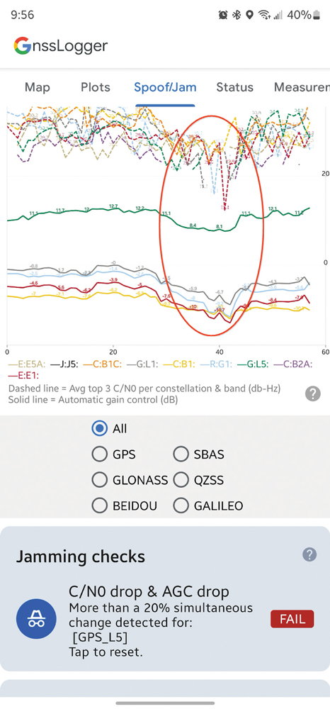
AGC and C/N0 both drop when a phone is held next to a Wi-Fi router (red oval). (Screenshot from Google)
The sharp increase in the past few years of instances of GNSS jamming and spoofing, much discussed in these pages especially with regards to civil aviation, also affects smartphones, smartwatches and other consumer devices. Google — which makes the Pixel phones as well as Android, the most used operating system, which is used by three quarters of the world’s smartphones — has been developing a tool to help detect these attacks.
It is based on the fact that the carrier-to-noise ratio (C/No) of the signal as well as the automatic gain control (AGC) of the GNSS radio in the phone can be good indicators of interference. “The AGC tends to dip when spoofing or jamming is observed,” said Mohammed Khider, Ph.D., manager and senior staff software engineer at Google. However, he pointed out, for jamming events the C/N0 value drops while for spoofing it increases.
Making use of this effect, desktop tools that log data and analyze the AGC and C/No have long made it possible to detect interference. Now, Android users can do the same thing on their phones in real time, using the spoof/jam tab in Google’s GnssLogger app. It creates a graphic of AGC and C/No for each GNSS constellation and band. Moreover, the app cross checks the GNSS signals with other independent sources of information to flag potential jamming and interference. Below the real-time plot of AGC and C/N0 are a series of additional automated jamming and spoofing checks.
This is an experimental feature, and the algorithms behind it will be further improved as research progresses, Khider pointed out. Moreover, it will not catch all jamming or spoofing. However, it will make it much easier to examine data related to these GNSS interference events in real time.
Google launched its GnssLogger app in 2020, and it has been a leading tool for the GNSS community to better understand positioning and navigation on smartphones. “It helped establish a de-facto CSV (.txt) standard for raw measurements and other data for Android devices that has been used in many other tools, including Google’s own Gnss Analysis app,” said Khider.
Last fall, in addition to the new spoof/jam screen discussed above, Google also launched GnssLogger for Wear OS, a new companion app for Android smartwatches that offers several of the key features found in the phone app, and a new measurements screen, which enables users to view GNSS raw measurements in real time.
The C-130 Hercules aircraft is used to rapidly drop cargo to provide relief after disasters or troops into battle zones. (Image: USAF Devin Doskey- 341st Missile Wing Public Affairs)
GPS Innovation Alliance (GPSIA) member companies are leaders in technology, transforming the digital and physical world around us. With countless essential applications, GPSIA members improve the industries that feed, build, move and connect communities across the globe. In times of need, the GPS industry is proud to rise to the occasion, whether through agriculture technologies, surveying equipment, navigation systems, essential communications tools, or humanitarian relief efforts. Simply put, GPSIA members are continually investing in lifesaving services at home and abroad.
Take, for example, the urgent need for humanitarian relief created by the ongoing war in Ukraine. Trimble has stood united to support the many affected and displaced Ukrainians; in addition to contributing through the Trimble Foundation to relief efforts in Ukraine and neighboring countries, Trimble also has provided GPS signal corrections to Ukrainian farmers at no cost, supplied 3D scanners for surveying damaged buildings, and worked closely with The HALO Trust to support demining activities in Ukraine by providing funding and commercial surveying systems to assist in precision mapping of landmines and unexploded ordnances.
Lockheed Martin’s C-130 Hercules aircraft has assisted essential humanitarian relief across the globe. Since its inaugural flight in 1954, this aircraft has enabled aid delivery, natural disaster relief, medevac services, search and rescue and more. Now equipped with GPS technology, the C-130 fleet has provided aid across the globe for decades — with L3Harris’ missionization solutions often at work to maximize the C-130’s utility. Similarly, Collins Aerospace’s state-of-the-art navigational technology has provided essential support to U.S. Coast Guard helicopters, with avionics upgrades that help pilots save time in emergencies and enhance situational awareness.
Garmin inReach devices can send and receive messages, navigate routes, track and share journeys and can trigger an SOS if needed. (Image: Garmin)
More broadly, Garmin inReach satellite communication devices have helped more than 10,000 individuals access emergency services, providing critical communications in natural disasters and humanitarian emergencies. In 2022, a powerful underwater volcanic eruption and tsunami devastated the island nation of Tonga, severing traditional communications channels for several weeks. Roy Neyman, a sailor equipped with this Garmin device, set up a communication center at a local restaurant to allow other residents to reach family and friends. Over two weeks, Tonga residents sent about 1,600 messages to loved ones around the world, offering peace of mind in the face of unthinkable destruction. Similarly, Apple recently launched an “Emergency SOS” service, which led to one of the first successful rescue efforts of two people who had driven off a highway in the Angeles National Forest.
CalAmp’s Fusion routers enable lifesaving emergency services to more than 400,000 residents in Oakland, California. Equipped with GPS, LTE and WiFi technology, these routers help Oakland Fire first responders quickly locate emergencies and access additional resources, such as building layouts or fire records, to provide the best possible emergency response. CalAmp’s technology provides an essential service to residents of Oakland and can be adapted to meet the changing needs of the community.
As the world of agriculture has come to depend on GPS technology, John Deere’s GPS-based agricultural services have helped farmers become more efficient. In turn, this has allowed farmers to harvest more crops for the masses and meet the ever-growing demand for food. With the annual growth in food demand estimated to be 1.4% over the next decade, John Deere’s critical investment in food banks in Mexico and training for farmers in Africa will help to ensure that all communities are able to access the food they need.
Across industries and government, GPS technology makes for a safer, more connected world. GPSIA is proud of its members’ dedication to global humanitarian efforts as well as critical services close to home. By constantly innovating, GPSIA member companies are creating technologies that provide critical services for everyday emergencies, natural disasters, and humanitarian crises across the globe.
A roundup of recent products in the GNSS and inertial positioning industry from the February 2023 issue of GPS World magazine.
SURVEYING & MAPPING
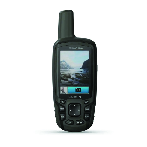
GPSMAP 64csx handheld GPS receiver (Image: Gamin)
Handheld GPS With navigation sensors and camera
The GPSMAP 64csx handheld GPS receiver comes with multi-GNSS support, TopoActive mapping, barometric altimeter, three-axis compass, and wireless connectivity via Bluetooth and ANT+ technology. It also has an 8 MP autofocus camera. The GPSMAP 64csx is built to withstand rugged terrain and is water-resistant. The highly sensitive receiver and quad helix antenna provide support from GPS, GLONASS and Galileo. Preloaded TopoActive maps include waterways, natural features, buildings and international boundaries. It is compatible with smartphones so users can receive email and text messages and share location data with others. Garmin, garmin.com
The Venus Laser RTK receiver comes with an inertial measurement unit. It can be used in its traditional mode with a range pole, or in laser mode without a pole, enabling GNSS surveying beyond typical limitations. In traditional mode, it has tilt compensation of up to 60° with an accuracy of 2.5 cm; in laser mode, it has the same tilt compensation but an accuracy of 5.5 cm. The receiver is powered by a SinoGNSS K8 high-precision module capable of up to 1,590 channels. It can survey using GPS, BDS-2, BDS-3, GLONASS, Galileo, QZSS and SBAS constellations. Other features include Bluetooth connectivity, more than 20 hours of battery life, and ruggedness (it is dust and waterproof and is designed to survive a two-meter drop). ComNav Technology Ltd., comnavtech.com
Leica iCON gps 160 (Image: Leica Geosystems)
Smart Antenna With features to increase productivity on the construction site
The Leica iCON gps 160 is a next-generation construction smart antenna designed to increase productivity in stakeout and measurement applications on the jobsite. It features a large color display with clear navigation for quick and easy setup without additional hardware. It is optionally available with an inertial measurement unit (IMU) for tilt-compensation functionality up to 20°. It seamlessly integrates with all Leica iCON construction instruments and controllers as well as the iCON field software for precise, real-time verification. Leica Geosystems, leica-geosystems.com
The Xsens Vision Navigator (Image: Movella)
GNSS inertial navigation Integrates position inputs from three high-accuracy sources
The Xsens Vision Navigator integrates position inputs from three high-accuracy sources including dual-antenna real-time kinematic (RTK) GNSS receivers; an inertial measurement unit (IMU) incorporating a three-axis accelerometer, a gyroscope and magnetometer; and a visual inertial odometry system. It can optionally accept input from an external wheel-speed sensor. The positioning sensor achieves centimeter-level accuracy when operating in GNSS mode with an RTK fix. When GNSS signals are not available, the product alone achieves accuracy of 2% of travel distance, or 0.75% when supplemented by wheel speed. Xsens Vision Navigator is suitable for outdoor positioning applications such as material handling equipment, commercial and specialist vehicles, last-mile delivery, inspection equipment and UAVs, agricultural equipment, mining equipment and utility robots. Movella, movella.com
SILC Eyeonic Vision System (Image: SiLC)
Coherent Vision Solution Delivers high levels of vision perception
The Eyeonic Vision System is a frequency-modulated continuous wave lidar solution, which delivers high levels of vision perception to identify and avoid objects with low latency. At the core of the Eyeonic Vision System is a fully integrated silicon photonics chip. It provides more definition and precision than legacy lidar solutions, with roughly 10 milli-degree of angular resolution coupled with millimeter-level precision. These features enable this solution to measure the shape and distance of objects with high-precision and at a large distance. The system combines the Eyeonic Vision Sensor and a digital processing solution based on a powerful field-programmable gate array. The flexible architecture enables synchronization of multiple vision sensors for unlimited points per second.
SiLC, silc.com
OEM
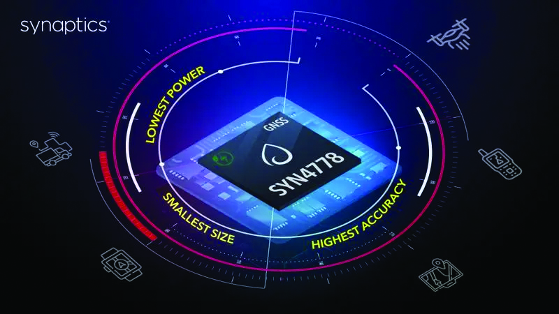
The SYN4778 (Image: Synaptics)
Integrated Circuit Designed for the internet of things
The SYN4778 is a small, low-power GNSS integrated circuit designed to extend battery life, reduce product size, and enhance performance of advanced location-based services for internet of things (IoT) devices — wearables, mobile accessories, asset trackers, UAVS and transportation devices. It includes advanced multipath interference mitigation using L5-band signals from GPS, Galileo, BeiDou, NAVIC, SBAS and QZSS. The chip also uses the L1 satellite band to reduce both the time to first fix, and the power consumed, improving the end-user experience and enabling product developers to add additional functionality and features to their IoT devices. Synaptics, synpatics.com
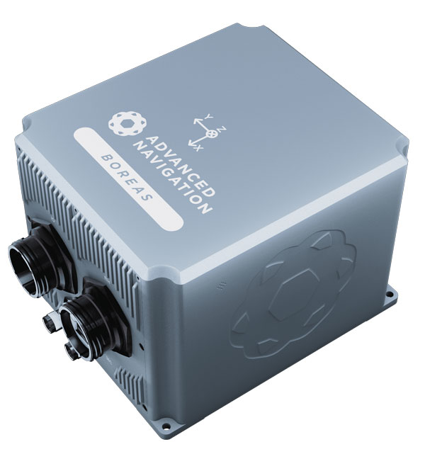
The Boreas D70 is a fiber-optic gyroscope (FOG) inertial navigation system (INS), part of the Boreas digital FOG series. The technology is suited to surveying, mapping and navigation across subsea, marine, land and air applications. It also could be adopted for vehicular applications, including autonomous vehicles and aircraft where weight and size are at a premium. The Boreas D70 combines closed-loop DFOG and accelerometer technologies with a dual-antenna real-time kinematic (RTK) GNSS receiver. These are coupled with an artificial-intelligence-based fusion algorithm to deliver accurate and precise navigation. Advanced Navigation, advancednavigation.com
The u-blox NEO-F10T (Image: u-blox)
Timing Module Dual-band and secure for 5G communications
The u-blox NEO-F10T offers nanosecond-level timing accuracy, meeting the stringent timing requirements for 5G communications. It is compliant with the u-blox NEO form factor (12.2 mm x 16 mm), allowing space-constrained designs to be realized without the need to compromise on size. The NEO-F10T is the successor to the NEO-M8T module, providing an easy upgrade path to dual-band timing technology. This allows NEO-M8T users to access nanosecond-level timing accuracy and enhanced security. u-blox’s dual-band technology mitigates ionospheric errors and greatly reduces timing error, without the need for an external GNSS correction service. u-blox, u-blox.com
TRANSPORTATION
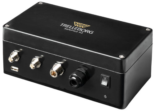
SafePilot P3 (Image: Trelleborg)
Maritime Systems Provides data on vessel positioning
The SafePilot P3 navigation system provides real-time data on vessel positioning and movement in tight waterways. It uses motion sensors and two GNSS antennas to measure the position and heading of vessels in three dimensions, minimizing time and difficulty associated with piloting procedures. SafePilot P3 has a backup battery to maintain functionality in the event of a power outage. This navigation system improves situational awareness while navigating waterways and ports globally, and also enhances communication between the captain, pilot, tug operators and canal personnel while vessels are transiting a canal and approaching a port.
Trelleborg, trelleborg.com
FusionEngine software (Image: Point One Navigation)
Positioning Engine Assures functional safety of ASIL-B
FusionEngine software, which is rated for automotive safety integrity level (ASIL), is now compatible with STMicroelectronics’ Teseo ASIL Precise Positioning GNSS chipset TeseoAPP. This assures functional safety of ASIL-B, a requirement for Level 3+ advanced driver assistance systems (ADAS). It can be integrated into several different host processors to enable high-level ADAS and autonomous driving systems. The combination of TeseoAPP’s receiver and the STA5365S external RF front-end provides dual-band measurement data for all visible GNSS satellites to the main host processor into which
FusionEngine is integrated. Point One Navigation, pointonenav.com
Ghost Autonomy Engine (Image: Ghost)
Autonomous driving software for level 4 driver assistance
The Ghost Autonomy Engine achieves the reliability required to bridge the gap between driver assistance capabilities L2 or L2+, and self-driving that does not rely on a human backup (L4). The software provides a stereo-vision neural network that delivers per-pixel depth in real time. It is capable of detecting and segmenting key features in a scene without needing to classify or recognize them. The physics-based perception system can handle the long tail of obstacles on the road, even those never seen before. Ghost, ghostautonomy.com
Vista-X120 Plus (Image: Cepton)
Lidar Provides 3D perception
The Vista-X120 Plus is a slim automotive lidar device for real-time adaptive 3D perception for advanced driver assistance. Its software-definable region of interest enables higher dynamic perception capabilities, while an adjustable central field of view with increased angular resolution improves accuracy in detection and classification of objects when driving. The region of interest is also configurable in real time in both horizontal and vertical directions. The Vista-X120 Plus is compact at 140 mm x 30 mm, improving OEM integration and placement options without disrupting vehicle appearance. Cepton, cepton.com
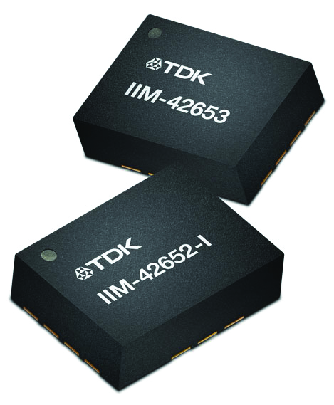
IIM-42653 and IIM-42652-I sensor platforms (Image: TDK Corporation)
Sensor Platforms Targets industrial and navigation applications
The IIM-42653 and IIM-42652-I sensor platforms consist of 6-axis IMUs, which target industrial and navigation applications requiring high force sensitive resistor (FSR) performance or inertial navigation software. The IIM-42653 platform — a robust, low-noise, low-power, 6-axis IMU — is capable of a gyro-programmable output of 4,000 dps and an accelerometer-programmable output of 32 g. These features make the IIM-42653 suitable for industrial-grade or high-end automated guided vehicles, automated mobile robots and unmanned aerial vehicles. The IIM-42652-I platform offers hardware authentication and can be integrated with TRACK dead-reckoning software from Trusted Positioning. TRACK filters GNSS multipath errors and provides a continuous navigation solution when GNSS signals are unavailable. TDK Corporation, invensense.tdk.com
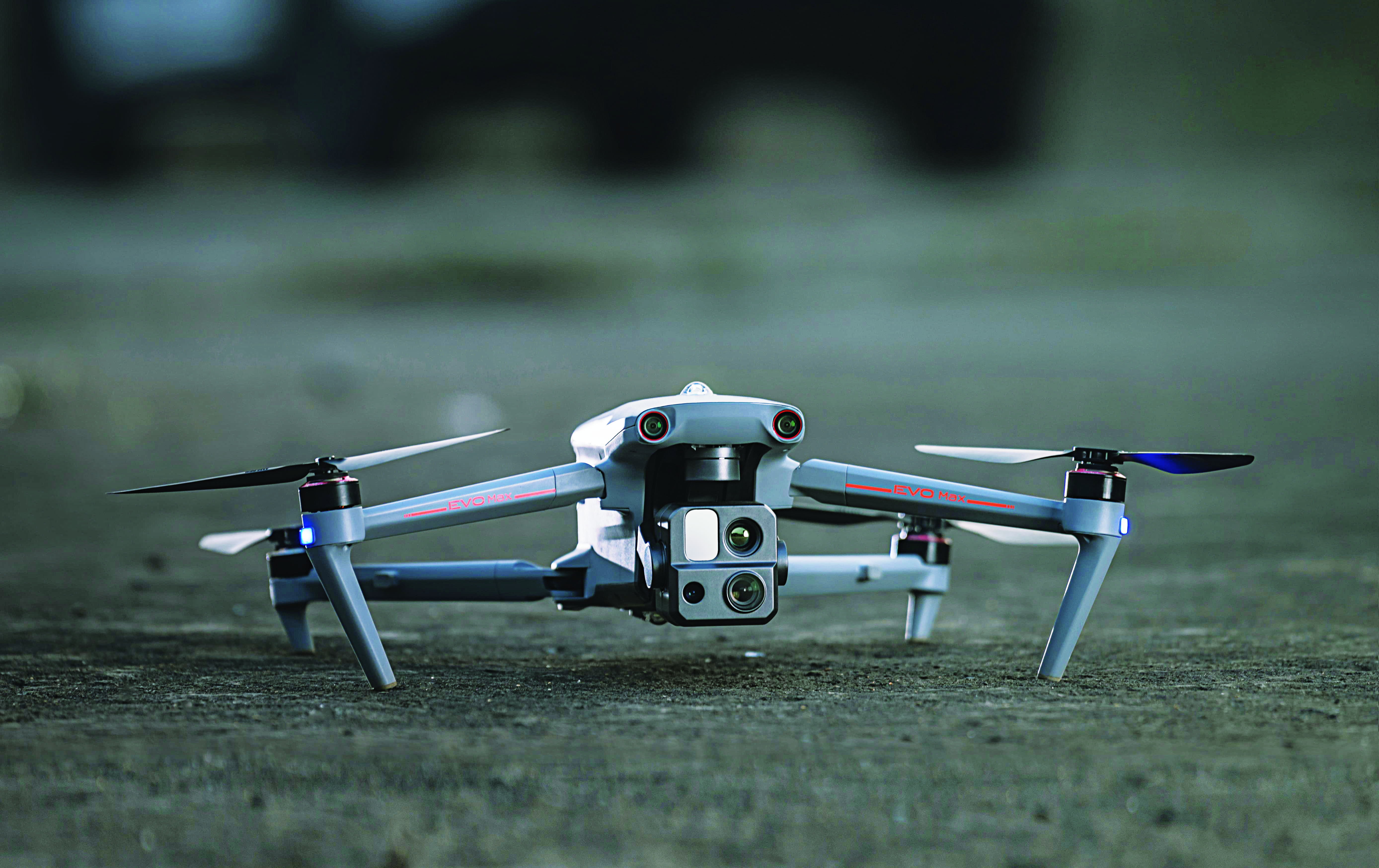
VO Max 4T (Image: Autel Robotics)
Flight Platform
For enterprise and professional applications
The EVO Max 4T autonomous flight platform provides omnidirectional obstacle avoidance and tri-anti-interference capability to ensure flight safety and stability in high-interference environments. It is equipped with three high-quality cameras including a 48 MP telephoto camera, a 50 MP wide-angle camera and an infrared camera. The platform has a range of navigation and data-acquisition functions, including 3D flight routes, PinPoint Mode, Team Work, Polygon Mission, Waypoint Mission and Oblique Photography. EVO NEST is a base for automatic take-off, landing, charging and mission planning for EVO series UAVs. It is designed for all-weather operation and can be easily transported. Autel Robotics, autelrobotics.com
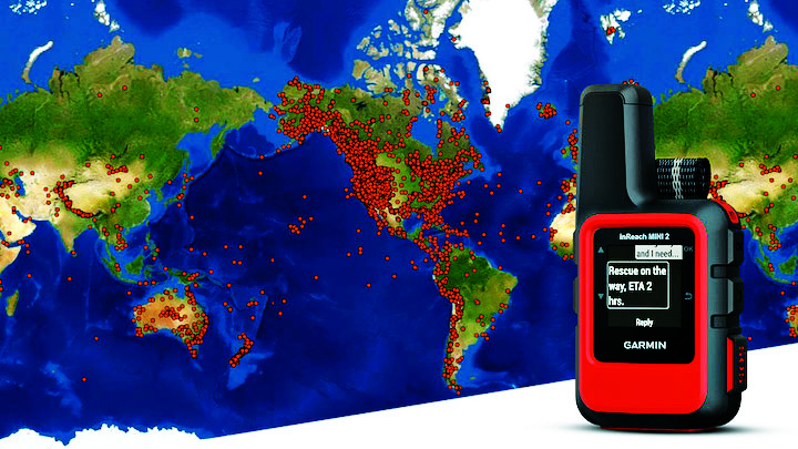
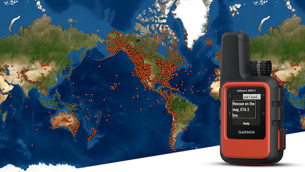
A Garmin inReach with a map showing incidents. (Photo: Garmin)
InReach devices have provided SOS assistance on seven continents in more than 150 countries
Garmin International has announced that 10,000 SOS incidents have been aided with its inReach handheld device. InReach technology allows for location tracking, two-way text messaging, and critical SOS emergency-response services.
The Garmin inReach provides two-way communication and a coordination center staffed 24/7 to serve users engaging in activities such as mountain climbing or camping.
Garmin provided the following insights into who is using the device’s SOS capabilities, where, and in what situations. For more data insights, visit this blog.
The top five activities that produced incidents include hiking/backpacking, driving, motorcycling, climbing/mountaineering and boating.
Mountain regions such as the Pacific Crest Trail, the European Alps, and nearly all of New Zealand seem to have a high propensity for SOS incidents. However, cities like Los Angeles, Phoenix and Aspen have all reported SOS incidents ranging from cycling to hiking.
Medical emergencies and injuries represent nearly 50% of the global SOS incidents, highlighting the preparedness inReach provides users to meet unexpected or unforeseen events.
Nearly one in five incidents were triggered by a good Samaritan, who purchased a device for their own peace of mind but were able to assist someone else in need.
The second highest number of SOS triggers (12%) comes from driving incidents. Many driving SOS incidents involve people needing help while on the road and outside of cellphone service.
A few InReach incidents are pet emergencies, unexpected natural disasters, and reuniting a child with a parent.
Garmin Response center
The inReach devices have a dedicated SOS button and 100% global Iridium satellite network coverage. Users can quickly report an SOS should an emergency occur.
Once an SOS is reported, even if no other action is taken by the user, the device sends a distress message to Garmin Response, a 24/7-staffed professional emergency response coordination center.
Garmin Response will communicate with the individual in distress, his or her listed emergency contacts, applicable search-and-rescue organizations and other available local resources. The staff will deliver a confirmation when help is on the way, provide updates on the status of the response effort, and remain engaged until the incident is resolved.
“The two-way communication of inReach is so important in an emergency situation,” said Sarah Kramlich, Garmin senior director of services and subscription strategy. “After initiating an SOS, Garmin Response will ask questions to learn more about the incident and what appropriate first responses are needed for rescue, whether a tow-truck or helicopter.”
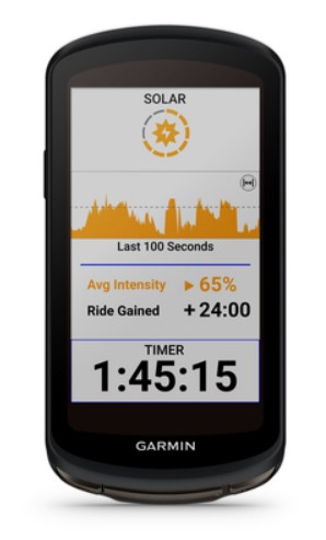
The Edge 1040 Solar has breakthrough solar charging and multi-band GNSS technology
Garmin International has announced the Edge 1040 Solar, a GPS-based bike computer featuring solar charging and multi-band GNSS technology.
Photo: Garmin
The Edge 1040 has a Power Glass-branded solar charging lens, giving cyclists more ride time between charges – up to 100 hours in battery saver mode – while multi-band GNSS technology provides more accurate positioning in challenging ride environments, such as dense urban areas or under deep tree cover.
The 3.5-inch touchscreen also features a refreshed, modernized user experience, giving cyclists easier access to key information, the ability to customize the home page and an improved ride summary view.
Its innovative advancements include:
Solar charging: The Power Glass solar charging lens extends battery life to up to 100 hours in battery saver mode, giving cyclists an additional 42 minutes per hour during daytime riding.
Multi-band GNSS technology: Provides better positional accuracy and coverage, even in challenging environments.
Cycling ability and course demands: The device can classify a cyclist’s strengths and weaknesses, focus on improvement and prepare for the demands of a specific course.
Power guide: Recommended power targets make it easier to manage efforts throughout a course.
Real-time stamina insights: Cyclists can monitor and track exertion levels in real-time during a ride.
Simple setup: Custom ride profiles prepopulate based on previous Edge data, ride types and sensors. From there, cycling activity profiles can be managed directly on a compatible smartphone from the Garmin Connect smart device app.
In the decades since the U.S. GPS became fully operational, GPS has become a highly innovative, successful and increasingly ubiquitous technology critical to applications and services touching the lives of almost every American today and for decades to come. As GPS-enabled technologies have become an irreplaceable part of our national infrastructure, growing more deeply ingrained each year, GPS is a success story of what can happen when government-backed R&D, paired with a light-touch regulatory approach, is turned loose in the private sector.
At the GPS Innovation Alliance (GPSIA), our member companies and affiliates are driving this innovation forward. While we use their products every day now, they’re also focused on inventing the future. Several key features are necessary to this continued success: a stable and predictable spectrum environment; a regulatory framework that fosters innovation and balances the fundamental technical needs of navigation systems; and appropriate, established interference protections where necessary.
Regulators must take care not to fundamentally depart from the longstanding approach to spectrum policy that has enabled the GPS technologies and services that underpin our economy. The prize on the other side of a well-calibrated policy is the next generation of GPS-enabled applications and products, which, as a GPS enthusiast first and foremost, I get a front row seat to our members building every day. These innovations span land, sea and space, unlocking opportunity for their U.S. government partners and consumers alike.
Innovations on Land, at Sea and in Space
On Earth, GPS-based products and services are getting even better at improving our everyday lives, helping farmers, builders, drivers and hobbyists work more efficiently and providing the critical inputs for everything from trucks to cell phones.
Take GPSIA member Trimble’s recently introduced R750 modular GNSS receiver, a connected base station used in both civil construction and agriculture that provides improved base-station performance and gives contractors, surveyors and farmers more reliable and precise positioning in the field. John Deere is likewise helping build next-generation precision agriculture technology with its new autonomous tractors, which will use GPS signals to ensure optimal plowing, planting and harvesting by adapting to real-time data analytics on soil conditions and other factors.
Garmin, a household name in GPS consumer products,continues to enhance satellite location and communication technologies for increased safety and user awareness, recently launching its inReach Mini 2 compact device that offers up to 30 days of battery life, integrated location and situational awareness technologies, and two-way texting and SOS capabilities.
Elsewhere, CalAmp recently celebrated two years of partnership between their LoJack Stolen Vehicle Recovery System and BMW Group Italy, the first step in a larger plan toward a GPS-based security solution for BMW’s full product range, while Apple continues to build revolutionary consumer tech, such as their GPS-enabled Apple Watch that can track workouts, activity, elevation and time, all without connection to an actual iPhone.
The ubiquity of GPS is particularly critical at sea. Collins Aerospace, for example, just launched Artemis Elite, the first–ever military underwater navigation system (MUNS) with M-code technology, that improves GPS signals’ precise positioning, navigation and timing (PNT) capabilities, making them more resistant to threats of jamming and spoofing. Garmin is also improving the consumer boating experience with its suite of OnDeck products, which pair onboard sensors and GPS to create a remote monitoring and management solution giving boaters 24/7 access to critical and timely information about their vessels.
Of course, GPSIA members are driving the effort to modernize the GPS satellite constellation itself. Lockheed Martin is building the next generation GPS III satellites and follow-on GPS IIIF satellites that will improve antijamming capabilities and geolocation accuracy for GPS-enabled devices, while L3Harris is building critical inputs on these satellites, such as their advanced navigation and timing payloads.
Our companies are also leading the way to help nations operate in space, providing critical GPS applications including guidance systems for crewed vehicles; the management, tracking, and control of communication satellite constellations; and monitoring the Earth from space.
Raytheon, for example, announced this month that it installed the first global aircrew strategic network terminal (ASNT) for the U.S. Air Force to enable protected communication capabilities for aircrews, while Lockheed Martinis the primary contractor in a cutting-edge project from the Space Development Agency to improve U.S. missile tracking and defense through a layer of multi-orbit satellites speaking to one another and sharing location data in real time.
Looking across GPSIA’s member companies, it’s clear that we live on a globe propelled by GPS. We should continue to give them the tools — and protect the regulatory framework — that has allowed them to do what they do best, which is bring us products that transform our daily lives for the better and innovate new technologies and services.
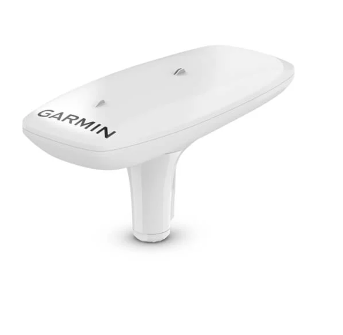
GPS-based navigation tool with multi-band GNSS provides reliable, accurate heading and position information
Garmin International Inc. has launched the MSC 10 marine satellite compass with multi-band GNSS and a fully integrated attitude and heading reference system (AHRS) for a smooth and accurate GPS-derived heading and position on the water.
“Garmin was the first to deliver a marine positioning receiver and antenna utilizing multi-band GNSS support, and we’re pleased to continue to bring this innovative technology to our customers with the MSC 10 satellite compass,” said Dan Bartel, Garmin vice president of worldwide sales. “An advanced navigation tool, the GPS-based MSC 10 won’t be impacted by magnetic interference, so even in challenging situations, you’ll know exactly where you’re headed.”
Utilizing both L1 and L5 GPS frequencies, along with multi-constellation support (GPS, Galileo, GLONASS and BeiDou), the MSC 10 provides precise positioning and heading accuracy within 2 degrees. Its 10-Hz position update rate delivers better, more detailed tracking information. By using satellite signals, it eliminates magnetic interference, which can degrade heading accuracy.
The MSC 10 is easy to install and can be used as the primary position and heading sensor across multiple systems, including autopilots. Along with heading, the MSC 10 will also deliver reliable, precise pitch, roll and heave information — even in rough seas — to a compatible Garmin chartplotter via the NMEA 2000 network. In the rare case that satellite signal is lost, it will seamlessly transition from GPS-based to a backup magnetometer-based heading.
NMEA 2000 certified, the MSC 10 is compatible with a wide range of Garmin chartplotters, including the GPSMAP 8400/8600 series, the new GPSMAP 7×3/9×3/12×3 series, and the keyed GPSMAP 10×2/12×2 series.
The MSC 10 is expected to be available this month.
The GPS Innovation Alliance (GPSIA) sent a letter on Feb. 16 to the White House National Economic Council, asking it solve the issues with Ligado interfering with GPS spectrum.
“Strong and unified leadership by the U.S. government is needed to preserve and advance GPS — leadership that recognizes the inherently unique functional and technical attributes of GPS,” wrote J. David Grossman, GPSIA executive director, in the letter.
Panel on risks to sat services
GPSIA’s J. David Grossman will be speaking Feb. 17 at 2 p.m. ET, in a panel discussion entitled “Satellite-Based Services at Risk?” Other speakers include former FCC Commissioner Robert McDowell; Capt. Steve Jangelis, representing the Air Line Pilots Association (ALPA); and Susan Avery, former president of the Woods Hole Oceanographic Institution. Register here.
The coalition, which counts Garmin, Apple and John Deere among its members, was ensnared in the dispute between Trump executive branch agencies and the Federal Communications Commission (FCC) over whether the commission’s Ligado approval decision in 2020 would affect GPS.
In the letter to NEC Director Brian Deese, the group argues that these squabbles “are not unique to GPS” and “reflect a continued pattern by which shared decision-making is replaced by the FCC acting with exclusive authority as the final arbiter.”
GPSIA recommends that the council
update a memorandum of understanding between the FCC and Commerce Department to help ease decision-making;
install a detailee from federal agencies managing GPS in the FCC’s engineering office; and
have each FCC commissioner add a technical adviser to its staff.
The letter concludes, “GPSIA and its members stand ready to be a resource to the NEC and others in the Administration seeking to more efficiently allocate spectrum, while protecting critical incumbent systems and services.”
Garmin has debuted the GPSMAP 65, 65s and 66sr, three new portable devices with improved technology, precision and connectivity. GPSMAP is the company’s line of premium outdoor navigation units.
The GPSMAP 65, 65s and 66sr offer multiband technology for positioning and tracking anywhere. They are the first Garmin portable devices to receive and use multiple satellite navigation frequencies.
The multi-band technology and expanded GNSS support with addition of the L5 frequency (GPS, GLONASS, Galileo, QZSS and IRNSS) allows for reduced estimated position error, giving users improved accuracy and awareness of their surroundings.
The new models include TopoActive maps of Europe, smartphone notifications, color screens, battery improvement, compatibility with the Garmin Explore app and more. All three are rugged, dust, shock and water resistant (IPX71 rated).
“We are excited to grow our popular lineup of GPSMAP handhelds and introduce multiple GPS frequencies into the series,” said Dan Bartel, Garmin vice president of global consumer sales. “We’ve expanded our satellite support so you can explore with confidence, no matter where you go or what the conditions are.”
GPSMAP 66sr
The premium version, GPSMAP 66sr, has a 3-inch color screen readable in all lighting conditions and is compatible with night-vision goggles. In addition, it has been designed to military standards for thermal performance and resistance to shock and water (MIL-STD-810G), and includes a built-in S.O.S. LED flashlight for assistance. To give the user even more confidence, incorporates ABC sensors (3-axis electronic compass), accelerometer and barometric altimeter), allowing users to obtain the most accurate data available at all times.
GPSMAP 66sr also provides global forecasts and weather through the Active Weather feature, updated through wireless connectivity via Bluetooth and ANT +. Via the Wi-Fi connection, users can download satellite maps.
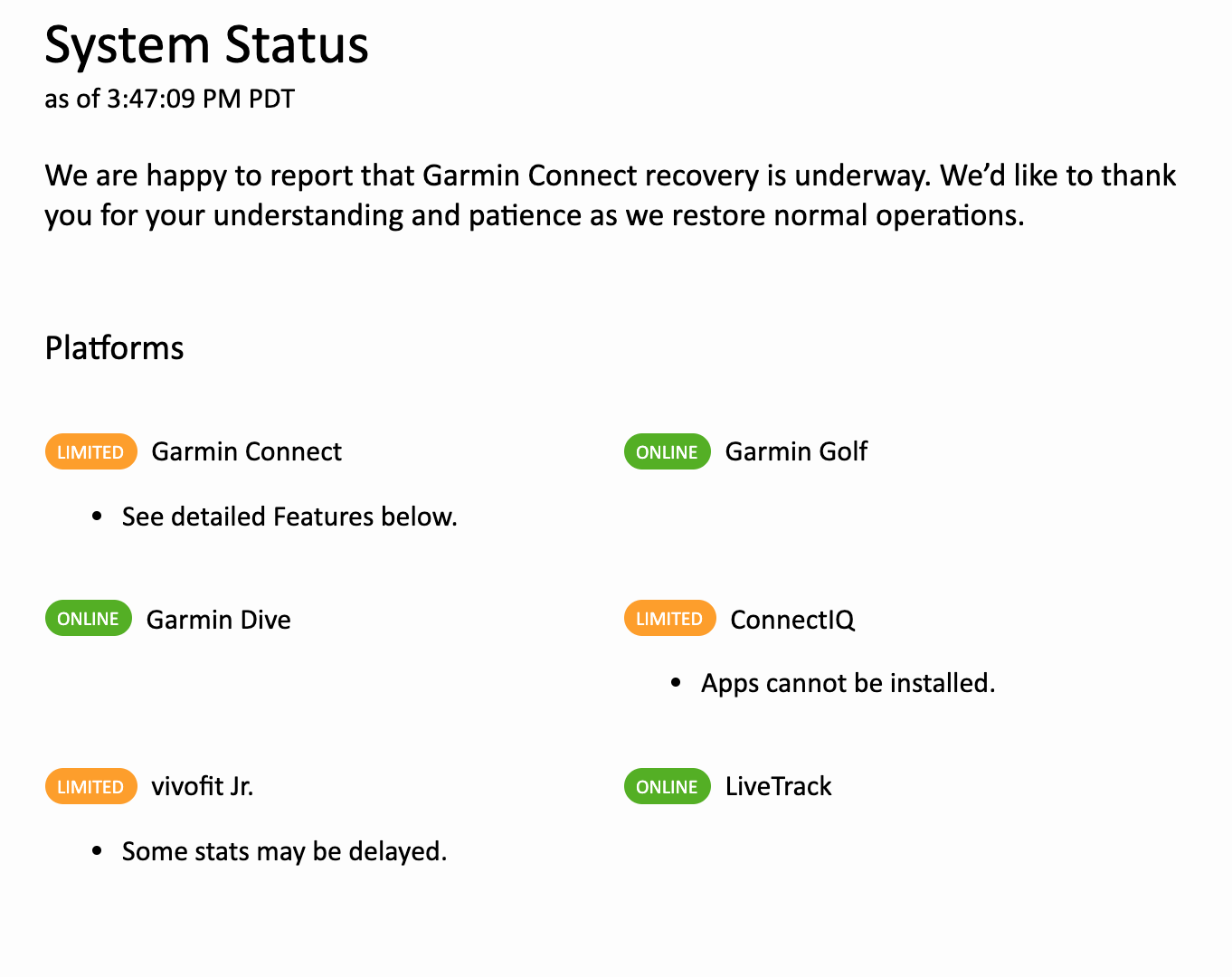
Following a ransomware attack last week that left Garmin Connect and other services offline, the company is gradually restoring its internet capabilities.
For those who make use of fitness tracking, however, Garmin Connect workouts are still not able to sync to devices and the app is under maintenance, reports CNN.
“We are happy to report that Garmin Connect recovery is underway,” the company announced on the Garmin Connect website. Some platforms have been given the green light, while others are offering limited services.
The company also said in a statement that there is “no indication” that customer data was accessed, stolen or lost.