By J. David Grossman Vice President of Regulatory Affairs Consumer Technology Association
This January, the annual Consumer Electronics Show (CES) — owned and produced by the Consumer Technology Association (CTA) — returned to Las Vegas. As the premier global platform for innovation, each year CES showcases the latest and greatest consumer technologies, from smartphones and wearables to self-driving trucks and electric cars.
GPS continues to play a central role in the technology we use daily. At CES, GPS-enabled technologies are found in nearly every product category, including 5G, internet of things (IoT), smart cities, vehicle tech and fitness wearables.
They are also among the CES 2022 Innovation Awards honorees, such as a connected bracelet that can alert emergency contacts and a robot that can identify the difference between crops and weeds.
How did GPS come to play such a critical role in devices as diverse as drones and smartphones?
Over the past 40 years, GPS has transformed from its origins as a military technology to one that no consumer or business can live without. During the 1990s, CTA members such as Panasonic and Sony pioneered commercially available GPS receivers.
At CES 1998, Garmin introduced StreetPilot, described as “one of the first practical and affordable GPS-based road navigation devices” and paved the way for huge growth in the consumer GPS market.
By the 2000s, GPS was no longer just a stand-alone technology. Following new Federal Communications Commission requirements, GPS-enabled smartphones opened the door for all-in-one devices. These products could deliver turn-by-turn navigation or identify the location of a lost or stolen device. In more recent applications, GPS technology provides the foundation for ever-more-complex mobile applications.
Opening of the 2022 Consumer Electronic Show. (Photo: Consumer Technology Association)
Foundational Technology
The evolution of GPS reflects a broader industry trend: innovators integrate foundational technology into successive generations of products, spurring development of new products and services. We’ve seen the same pattern play out for Wi-Fi, Bluetooth and Near Field Communication (NFC), which enables the latest tap-to-pay technologies. Hundreds of companies simply would not exist without free, global access to GPS signals!
With GPS, ridesharing companies such as Lyft match drivers and passengers, lead drivers to a precise pick-up location, and chart out a safe and efficient driving route. GPS-integrated smartwatches allow runners and cyclists to easily track pace and distance, a huge boon for many of us in the pandemic era. Closer to home, GPS-enabled pet collars help families keep tabs on their furry friends.
Revolutionary
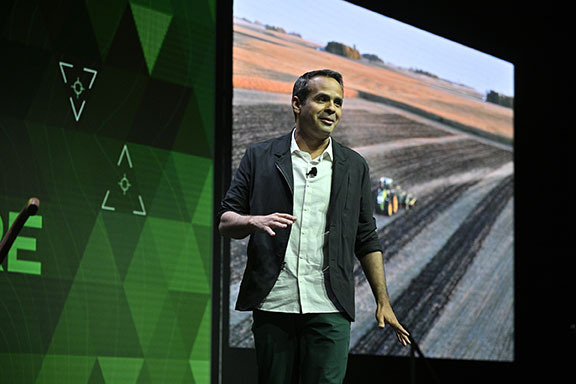
Beyond the technology we use daily, GPS technology is also revolutionizing such industries as agriculture. Thanks largely to GPS, centuries-old businesses are now technology companies. For instance, John Deere leveraged its 185-year history of building tractors and combines GPS with other location technologies to steer semi-autonomous tractors with centimeter accuracy. In addition to the time and efficiency benefits for farmers, technologies like these support sustainable agriculture by reducing the use of pesticides, water, seed and fertilizer.
John Deere held a Media Days press conference at Mandalay Bay during CES 2022. (Photo: Consumer Technology Association)
The success of GPS is important for our industry’s success, and I am proud of the role GPS plays in everyday life. Modernization of GPS, supported by the U.S. government and industry, will enhance the accuracy, reliability and resiliency of the technology, which in turn will ensure GPS remains central to the innovation economy.
F. Michael Swiek, president, Mike International LLC
It is often said that “Behind every successful man there is a woman.” Likewise, if we look behind every significant event, policy statement, technological achievement and milestone in GPS history, there are people. They make the textbook chronologies of impressive progress both personal and human.
My own 30-year association with GPS has tracked closely with that of GPS World. Here are vignettes that sit most warmly in my “family snapshot album” of great moments in GPS.
In December 1994, the Civil GPS Service Interface Committee (CGSIC) held its first international meeting in Edinburgh, Scotland, hosted by the Northern Lighthouse Board (NLB). The small team of Americans attending the meeting were invited the following day to participate as the “International Team” in the annual NLB quiz competition held in a venerable pub. The competition is hotly contested each year among the NLB divisions, with the winning division commemorated with a brass medallion on a large wooden plaque kept for decades in NLB headquarters. To everyone’s chagrin, the Americans won. The good humor and boisterous camaraderie of that evening laid the foundation for close and candid dialogue between U.S. and European institutions on a wide variety of satellite navigation issues for years to come.
In 1996, Charlie Trimble was to introduce Vice President Al Gore in a ceremony at the White House to announce a Presidential Policy Statement on GPS. On the scheduled day, Charlie was unable to enter the White House, despite being vouched for by White House officials, because he was carrying no photo ID. White House security asked me if I had anything official with Charlie’s picture. They finally accepted a copy of the Trimble Navigation annual report, because in the words of one security officer, “I’ve heard of fake driver’s licenses, but not fake corporate annual reports.” Charlie was admitted.
On September 11, 2001, all of us attending CGSIC and ION in Salt Lake City sat stunned in our conference room watching the news reports from New York. Our meeting sessions were canceled, but we came from our hotel rooms because we needed to be together as friends in our shock and confusion, worrying about our families and friends and what the days ahead would be like. Anyone with a cell phone able to get a line out gladly shared it.
“I’ll only be a minute, just want to check with my family.”
“Talk as long as you want.”
In the mid-1990s in the ION exhibit hall, I was walking and talking with Charlie Trimble, Randy Hoffman (founder of Magellan Systems) and Gary Burrell (co-founder of Garmin), who were engaged in good-natured trash talking about each others’ companies, products and personalities. Glen Gibbons, founder of this esteemed publication, came across us, smiled, and said he was surprised to see such a congenial group of competitors. Charlie responded that in the marketplace they were competitors, but at ION they were all colleagues.
Glen added, “So, all friends!”
All three blurted, “Don’t go that far!” amid more laughs and grins.
The Japan GPS Council became one of the earliest and most influential industry groups in helping to guide the evolution and growth of GPS policy and industry, due to the personal passion of Hiroshi Nishiguchi. When meetings were held in Washington, Nishiguchi, other international representatives, industry and government officials would be guests in our home for convivial dinner chats. Nishiguchi became so comfortable, we considered him like family. He would leave a cardigan sweater in our coat closet between visits, and upon entering our house would remove his tie and suit jacket, go to the closet, and put on his sweater — like Mr. Rogers — before relaxing for the evening. He performed this ritual even when accompanying senior Japanese officials.
So, while technological milestones and policy commitments tell a great deal of the story of GPS, there are also the unique and cherished people, and the privilege it has been to know them as friends.
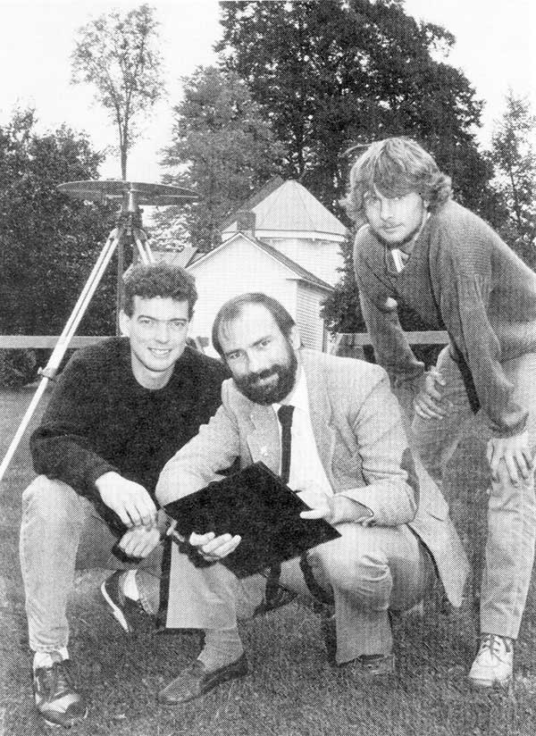
1990: UNB Professor Richard Langley and two graduate students use a GPS antenna (recognize it?) on a tripod to re-measure a historical baseline. (Photo: UNB Perspectives)
When GPS World published its first issue in January 1990, only 15 GPS satellites had been launched, including the 10 prototype or Block I satellites. And four of those early satellites had ceased operation. But there had been enough satellites in orbit for more than a decade to permit early commercial and scientific use of the system. There were even handheld receivers for personal navigation, albeit somewhat larger than those we have today. But it was clear that GPS was going to take off in a big way, and that there was a business case for launching a monthly magazine (bimonthly in its first year) about GPS for professionals in the positioning, navigation and timing communities.
The new magazine was to feature a blend of news, product announcements and articles about GPS, including cutting-edge research on GPS technology and its applications taking place at universities and research institutes around the world. That is why Glen Gibbons, the founding editor of GPS World, reached out to the University of New Brunswick (UNB), an early leader in GPS research and education, to manage a column to be called simply “Innovation.” Glen stipulated that “the column should deal with issues that have broad application and interest and are presented in terms that are accessible to as wide a range of readers as possible.”
Four faculty members were engaged in GPS research at UNB back then: David Wells, Alfred Kleusberg, Petr Vaníček (who famously foretold of the GPS watch back in 1983), and me. Dr. Kleusberg and I volunteered to manage the column and to scour academia and government and industry labs to find authors to write the column’s articles — or to write them ourselves, which we sometimes did. Beginning in 1997, I took over as the sole coordinator of the column — a role I have continued to this day.
There have been close to 300 “Innovation” articles since the first one in the premier issue of the magazine. I’ve also contributed to a number of news and feature articles in the magazine over the years. I might just be the longest-serving active GPS “journalist.” I’m still a full-time teaching and research professor at UNB, and recently took over as the editor-in-chief of The Institute of Navigation’s journal NAVIGATION, but I still have time to write for GPS World and hope to continue to serve the magazine in the years to come.
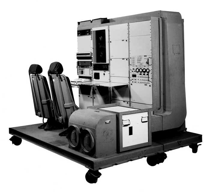
1976: The first military GPS five-channel receiver built in one of several programs that studied the feasibility of GPS. The receiver weighed more than 270 pounds and had seats for two operators. (Photo: Rockwell Collins/Smithsonian)
Like the internet before it, GPS started as a niche technology and became a universally recognized one, though much misunderstood and often taken for granted. Both systems originated in the U.S. Department of Defense (DOD) to support military missions, and then exploded into mass-market civilian technologies. While the internet passed from military to civilian hands very early in its history, GPS is still operated by the U.S. Air Force, making it a unique experience for the DOD: a system for which it is responsible that has orders of magnitude more civilian applications and users than military ones.
GPS has transformed entire professions — most notably, surveying; created new industries — such as ride sharing; boosted innumerable fields of scientific research — from archaeology to zoology; facilitated many aspects of everyday life — such as finding retail outlets and getting there; and given an advantage to U.S. military forces. One application discussed 30 years ago that has not yet lived up to its promised return on investment is precision agriculture.
Challenges and debates that loomed large in the early days turned out to be growing pains —most notably, Selective Availability (SA). In 1990, Javad Ashjaee reflected the attitude of much of the GPS industry and user community when he said, “I can’t think of a word to say how bad it is.” Other debates have proven more persistent — such as the interference threat posed by LightSquared, reborn after bankruptcy as Ligado Networks.
GPS first drew considerable publicity in the wake of Desert Storm, when it became the subject of television features, newspaper reports, and special sections in the pages of recreational catalogs. “Ironically,” Brad Parkinson pointed out in September 1994 in GPS World, “civil companies [such as Garmin] developed most receivers used in Desert Storm, with no help from military sponsorship.” Later that decade, while most people were finally aware of GPS technology, it began disappearing deep into its applications and the systems that use it.
In September 1991 — three and a half years before U.S. Air Force Space Command declared the system’s full operational capability (FOC) on April 27, 1995 — in a speech to the International Civil Aviation Organization in Montreal former FAA Administrator James B. Busey said: “I want to emphasize that we fully support the eventual replacement of [GPS] by other systems — and we are certain that will happen.” That may still happen, in the distant future. However, what Busey did not foresee is that GPS became but an element, though a key one, in a much larger positioning, navigation and timing (PNT) system. This worldwide system includes three other GNSS and two regional ones, several publicly and privately operated augmentation services, and a wide range of complementary and alternative technologies. These include inertial navigation (which has advanced much in the past three decades) and RF signals of opportunity. It may soon include navigation signals from non-GNSS satellites, eLoran, enhanced distance measuring equipment, and Earth-fixed navigation using very low frequency.
I began my current career in geospatial technologies exactly 20 years ago, as this magazine’s managing editor, just a few months after the end of SA increased GPS’ accuracy by an order of magnitude, and equally expanded the number of its potential applications. Yet today, I still marvel at how pervasive this technology has become and how much further it will transform our lives.
I will end with a quote from an early GPS World columnist, Hale Montgomery, who wrote in October 1991, “GPS users show an insatiable appetite for ever more precise data. Give them a mile and they want an inch.”
Seeking back issues: I have the entire collection of GPS World’s print edition, except for the first issue, the 10 issues in the second year (1991), and the September through December 1993 issues. I would be thrilled to receive those missing issues, or facsimiles, from anybody who has them. Email [email protected].
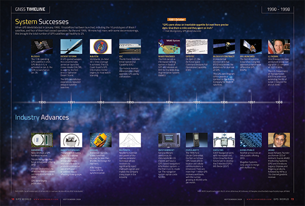
GPS World’s 30th anniversary GNSS timeline provides highlights in both system and policy development and industry over the past three decades. The timeline originally appeared in the September 2020 Special 30th Anniversary Supplement. Download the PDF.
On April 2, a new museum exhibit will open that focuses on the U.S. Air Force’s role in the management of GPS satellite systems.
The National Museum of the United States Air Force is holding a grand opening event for the new GPS Exhibit from 2-3:30 p.m., with remarks by U.S. Air Force personnel involved with the exhibit followed by light refreshments.
The museum is located at 1100 Spaatz Street, Wright-Patterson Air Force Base, Riverside, Ohio.
On April 2, 2020 a new exhibit will open focusing on the U.S. Air Force role in the management of GPS satellite systems. (Artist’s concept: USAF)
History and Benefits. GPS began as a military navigation tool in the early 1960s. Later, the U.S. Air Force became the lead organization for developing the system. It manages the system, providing highly accurate position, navigation and timing information to users worldwide, for free.
The exhibit describes what GPS is and how it works by outlining satellite and ground systems and their historical development. It explains how atomic clocks and GPS satellites enable all kinds of important activities.
These include mapping and navigation for everyday users and the military, commerce, farming, construction, cell phone systems, the power grid, and climate research.
The exhibit also explains how satellite orbits work, and it outlines the problem of “space junk.”
Hands-on. Interactives and videos help all ages better understand GPS, learn how to find their location on the Earth, and see how orbits and satellites work.
The museum will be open late on opening day, allowing guests to tour the museum until 8 p.m., with an opportunity to walk inside an AC-130A. The Lockheed AC-130 gunship is a heavily armed, long-endurance, ground-attack variant of the C-130 Hercules transport, fixed-wing aircraft.
The exhibit opening will take place in the Space Gallery (fourth building).
On Dec. 3, four U.S. engineers were awarded the 2019 Queen Elizabeth Prize for Engineering during a ceremony at Buckingham Palace for their work creating the first truly global, satellite-based positioning system, GPS.
The QEPrize is the world’s most prestigious engineering accolade, a £1 million prize that celebrates the global benefit of engineering innovation on humanity. The honorees were announced in February.
His Royal Highness The Prince of Wales presented the trophy to Dr. Bradford Parkinson, Hugo Fruehauf, Richard Schwartz and Anna Marie Spilker, who accepted the award on behalf of her late husband, Professor James Spilker, Jr. Learn more about Spilker from his wife’s account.
Bradford Parkinson — often regarded as the “father of GPS” — led the development, design, and testing of the system. Hugo Fruehauf developed a highly accurate, miniaturized atomic clock, a foundational component of the system. Richard Schwartz engineered a satellite hardened to resist intense radiation in space, with a lifespan three times greater than expected. Professor James Spilker, Jr, was the main designer of the GPS civil signal and, with his team at Stanford Telecommunications, built the receiver that processed the first GPS satellite signals.
Lord Browne, chairman of the Queen Elizabeth Prize for Engineering Foundation, highlighted the critical role of collaboration in engineering, and in groundbreaking innovations such as GPS: “Our laureates’ success was the result of inter-disciplinary collaboration, a drive for excellence, and an ability to turn the fruits of scientific discovery into practical solutions. That is what engineers do,” he said.
Today, an estimated four billion people around the world use GPS. At just $2 per receiver, GPS provides an accessible service and a powerful tool that people can integrate with their applications. Simple smartphone apps can track disease outbreaks, self-driving tractors can optimize crop harvests, and sports teams can improve team performance. New applications for GPS continue to revolutionize entire industries, and its annual economic value has been estimated to be $80 billion for the USA alone.
GPS combines a constellation of at least 24 orbiting satellites with ground stations and receiving devices. Each satellite broadcasts a radio signal containing its location and the time from an extremely accurate onboard atomic clock. GPS receivers need signals from at least four satellites to determine their position; they measure the time delay in each signal to calculate the distance to each satellite, then use that information to pinpoint the receiver’s location on earth.
This year’s QEPrize trophy was designed by 17-year-old Jack Jiang from Hong Kong. Jack’s elegant trophy design won the 2019 Create the Trophy competition, an international competition that invites those aged between 14-24 around the world to submit innovative trophy designs for the world’s leading engineers. The 2019 competition saw a record number of entries, with submissions stemming from over 50 countries worldwide.
From left: Lord John Browne, Richard Schwartz, HRH The Prince of Wales, Bradford Parkinson, Hugo Fruehauf, Anna Marie Spilker at the Queen Elizabeth Prize for Engineering ceremony at Buckingham Palace, December 3, 2019. (Photo: Jason Aldean)
Lord Browne of Madingley, Chairman of the Queen Elizabeth Prize for Engineering Foundation, said, “This year’s laureates have demonstrated that engineering makes things happen. With the first global, satellite-based positioning system, they created an engineered system which provides free, immediate and accurate information about position and time, anywhere around the globe.
“The world now depends on GPS completely and without exception. The high-frequency trading systems, telecommunications and electricity grids of today are all built around GPS. And we will rely on it for the drone delivery systems, self-driving cars and climate monitoring solutions of tomorrow.
“In honoring the 2019 prize winners, we hope to inspire the next generation of engineers to continue to push back the frontiers of the possible.”
Bradford Parkinson said: “Today marks a landmark moment in all of our lives—there is no prize for engineering greater than this, it is an honor. This recognition reflects the responsibility incumbent upon those developing technology today to strive to do so for the good of humanity. Day-after-day, we are astounded at the new ways in which people across the world use GPS. It is a ‘System for Humanity’ in each and every sense.”
Hugo Fruehauf said: “The accuracy of modern GPS satellites astounds me. The atomic clocks we built for the satellites were accurate to within billionths of a second, but today’s generation are working a factor of 100 times better than that. They’re a lot like wine, in a sense—they only get better with time. And they have to be accurate; the timing for GPS is used for core systems around the world—vital infrastructure like banking systems, telecommunications networks, and power grids. Today the world relies on those clocks.”
Richard Schwartz said: “One of the best things about GPS is its accessibility. We designed the system to produce a signal that anyone can use, regardless of where they are on the planet. Today, engineers around the world can still access that signal, for free, and use it to build creative solutions to benefit people around them. It took a great deal of collaboration to make the system work, and it’s great to see the next generation collaborating on innovative products now because of that.”
Anna Marie Spilker, on behalf her late husband, Professor James Spilker, Jr, said: “Jim’s mission statement has always been to create, teach, and mentor for world-changing benefits to humanity through his engineering talents. When working on GPS, Jim knew that it could be of profound benefit globally, and he was right; because of their work, Jim and his colleagues have helped billions of people around the world. He was immensely proud of that. He said many times that ‘Engineering technology is the necessary catalyst for progress to world changing benefits to humanity; it’s magic.’”
Association recognizes key role the agency has played in furthering GPS.
The GPS Innovation Alliance (GPSIA), an organization dedicated to furthering GPS innovation, creativity and entrepreneurship, commends NASA — the U.S. National Aeronautics and Space Administration — on its momentous 60th anniversary. GPSIA celebrates the occasion by recognizing the vital role NASA has played in furthering and facilitating the growth of GPS around the world.
NASA has long been an integral supporter of GPS technologies, from its origins in the first space shuttle program, to the launch of the International Space Station (ISS), to the recent announcement of plans to develop an artificial intelligence-based GPS for space.
Throughout its history, NASA has played a critical role in the success of expanding GPS systems. NASA manages the Navigator GPS receiver, developed by its Goddard Space Flight Center, which has pushed GPS satellites out of lower earth orbit and beyond to enable high altitude applications and track weaker and more rural GPS signals with increased accuracy.
The Global Differential GPS System (GDGPS), a network of more than 350 GPS monitoring stations from 200 contributing organizations in 80 countries developed and operated by NASA’s Jet Propulsion Laboratory, provides an unparalleled combination of real time positioning accuracy and availability and acts as the largest network providing global, multiply-redundant, real time coverage of all GPS satellites at all times.
“GPS contributes immeasurable value to our economy and is used in almost every industry sector,” said NASA Administrator Jim Bridenstine. “It is crucial for our way of life on Earth — the way we communicate, navigate, conduct banking transactions, and so much more rely on our GPS systems. As NASA looks to its future endeavors in exploration and discovery, GPS will remain a cornerstone of technology to accomplish its missions. NASA looks forward to its continued work with the GPS Alliance.”
With the establishment of the National Executive Committee for Space-Based Positioning, Navigation, and Timing in 2004 and other governing bodies since, NASA has also acted as a thought leader on policy trends in the field, advising on and advocating for protections of GPS , one of the world’s most important and ubiquitous public resources.
“The alliance, on behalf of its members and the GNSS industry, congratulates NASA on six decades of cutting-edge innovation and wishes the agency continued success for many decades to come,” said J. David Grossman, executive director of the GPS Innovation Alliance. “As one of the most recognizable technologies in the world, GPS supports navigation, public safety, financial transactions and utilities and varied industries worldwide. We applaud NASA for its unwavering commitment to scientific innovation and to GPS around the globe, now and in the future.”
The GPS Innovation Alliance recognizes the ever increasing importance of GPS and other GNSS technologies to the global economy and infrastructure and is firmly committed to furthering GPS innovation, creativity and entrepreneurship. The GPS Innovation Alliance seeks to protect, promote and enhance the use of GPS.
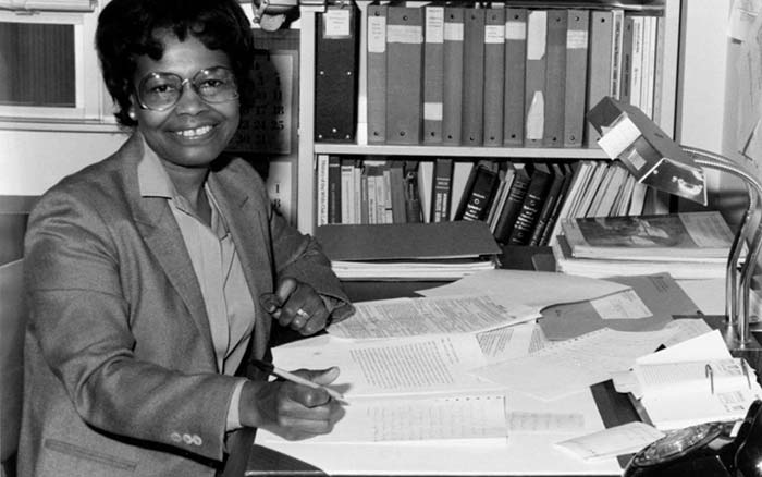
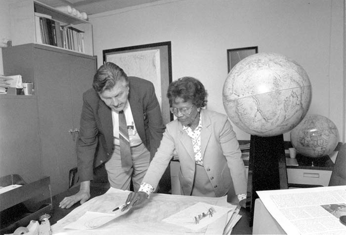
For Black History month in February, the Free-Lance Star of Fredericksburg, Virginia, profiled a woman few of us know about — Gladys West.
Capt. Godfrey Weekes, then-commanding officer at the Naval Surface Warfare Center Dahlgren Division, described to the newspaper the “integral role” played by West.
Gladys West’s work helped develop the Global Positioning System. (Photo: U.S. Navy)
“She rose through the ranks, worked on the satellite geodesy and contributed to the accuracy of GPS and the measurement of satellite data,” he said. “As Gladys West started her career as a mathematician at Dahlgren in 1956, she likely had no idea that her work would impact the world for decades to come.”
West collected data from the satellites, focusing on information that helped to determine their exact location as they transmitted from around the world. Data was entered into large-scale super computers that filled entire rooms, and she worked on computer software that processed geoid heights (precise surface elevations).
As a girl growing up in Dinwiddie County, Virginia, Gladys knew she didn’t want to work in the fields or a tobacco factory like her parents did.
“I was ecstatic,” she said of her career. “I was able to come from Dinwiddie County and be able to work with some of the greatest scientists working on these projects.”
Jim Colvard, technical director at NSWC Dahlgren from 1973 to 1980, knew West as a student in his graduate program and as a professional employee. “She was an excellent student and a respected and productive professional,” he wrote in an email. “Her competence, not her color, defined her.”
Gladys West, at Dahlgren with Sam Smith in 1985, looks over data from the Global Positioning System she helped develop. (Photo: U.S. Navy)
The day started like any other day. The land surveying crew loaded up their vehicle, equipment and marching orders to tackle the next project on the list.
This field party is like most surveyors across the globe — they are equipped with the latest surveying technology including GPS base and receivers, robotic total station and a UAS for aerial photography. These tools are necessary to be competitive in today’s surveying arena as speed and productivity are paramount to the success of the project and the company.
But on this day, any device with the ability to determine geographic location via satellite reception was rendered useless.
Today became known as the day that GPS went away.
How we became dependent on GPS
Let’s back up the story to the introduction of GPS and how our dependency on this technology came to be. With the invention of satellites culminating with the Russian effort to launch Sputnik, the United States became involved in a “race to space.” Our early efforts to use satellites were proven worthy with the successful ability to track submarines by reception of radio signals and trilateration.
Further enhancements through research resulted in the development and creation of the NAVSTAR satellite in 1978. By 1993, 24 satellites were in orbit to make the GPS system fully functional (NASA.gov).
Meanwhile, the Russians were committed to a satellite network for navigational purposes during the same time period. The first satellite, Kosmos-1413, was launched in 1982 with the full 24 satellite constellation becoming operational in 1995.
Together, these systems (known as global network satellite systems or GNSS) allowed for location and navigation abilities never thought possible, and the surveying community began its adoption of the technology.
Early survey adopters of GPS were usually large engineering firms, state departments of transportation (DOTs) and federal agencies that could afford the large financial commitment to the equipment (both GPS and computers), software and computing costs required to use the technology.
The data-collection times were long, and the software analysis required enormous patience and extensive mathematical knowledge, but the results were beyond what the everyday surveyor had ever before accomplished.
Significant distances could now be measured with the same or better accuracy than taping or using an electronic distance meter could have provided. The true revolution came when real-time kinematic (RTK) GPS was invented and was affordable to the everyday surveyor (GPS World, May 2016).
S/A and A-S
Most GPS users, especially operators of survey-grade receivers, are not aware of the early days of satellite navigation and the military’s use of selective availability, otherwise known as S/A (GPS World, Sept/Oct 1990). This methodology was implemented by the Department of Defense (DoD) on May 25, 1990 to limit accuracies for non-military GPS users.
This procedure was created to allow erroneous timing at random occurrences throughout transmission of satellite radio signals. These variations in timing more than negatively tripled the normal precision of an autonomous GPS position calculation, all in the name of introducing uncertainty to potential enemy users.
And if S/A wasn’t enough, the DoD also could implement another deterrent called anti-spoofing (A-S) and encrypt the precision or P-code of the satellite signal. The big factor here is that the general public (in our case, the surveying community) didn’t know if or when A-S was turned on. These factors were frustrating to the GPS user, so data collection and coordinate determination became a tedious operation.
Early receiver use by surveyors relied on differential GPS data collection for high-accuracy location (<10 cm or better). This method consisted of placing one or more receivers on known positional points (usually on monuments published through the National Geodetic Survey) while simultaneously performing data collection on new points for positional establishment.
Prior to S/A, the software utilized to analyze and reduce the data collection provided feedback on “bad” data, but there were usually environmental issues causing the problem (such as cycle slips and radio interference.) The software would highlight the suspect data for the reviewer to determine validity and acceptance.
Because of the nature of differential GPS data collection, error checking remained the same once S/A was implemented. If the software calculated an incorrect coordinate at a known point, the same measurements to the new survey point were dismissed as a false reading.
Surveyors were mostly left unfazed by S/A as real-time kinematic (RTK) and real-time network (RTN) follow a similar procedure utilizing a correction from a known terrestrial point. Even with the anti-spoofing activated, the surveying profession continued to use this high-tech location system that revolutionized long distance measurement. Things have been running along smoothly with steady improvement of receivers, data collectors, and data coverage until…
The day it goes away
…the unthinkable happens. Our national satellite system is no longer available.
It doesn’t matter why GPS has gone away on this day. It could be for many different reasons: federal budgets; enemy interference such as geomagnetic disturbances (GMD) or electromagnetic pulse (EMP);
conventional or nuclear war; interference from solar storms, asteroids, or comets; or the system just simply breaks.
Artist’s rendering of a cross-section of the Earth’s magnetosphere. (IMAGE: NASA)
Another thing for all users of GNSS to consider in these tumultuous times is how newer systems are integrating other countries’ satellite networks into their navigational observations.
Our relationship with the Russian government can be on unsteady ground from time to time, so our use of their GLONASS signals must be reviewed for accuracy as well (See GPS World, August 2017).
It won’t matter whether a spoofed satellite signal originates from a private Russian hacker or from their actual government; it will still lead to incorrect information and bad data. Imagine having to revise a plat because the GLONASS data was purposely corrupted!
Obviously, the main reason they would allow transmittal of misinformation would be for military reasons, but I can only imagine their joy of messing with professional navigation and the recreational users in the U.S. These opportunities will also apply to the Chinese and Indian constellations, too.
We’re not ready
The bottom line is that we, the U.S., aren’t ready for it. Whatever may be the reason for the failure, we do not have a backup plan and have relied much too heavily on satellite navigation. Gone is our ability to navigate through our electronic devices, including smartphones, fitness trackers, in-car mapping and, yes, high-precision surveying equipment. These items have now become door stops and space wasters.
This new conundrum doesn’t just stop with the surveyor and recreational GPS equipment. A significant amount of construction equipment relies on machine control, from bulldozers and road graders to high-rise cranes.
This will also affect a large amount of agricultural equipment and processes. Those high-tech tractors with autosteer and computer-guided planters? Back to the drawing boards. So many things in our lives today are guided or controlled by navigational systems designed around GPS use, and the surveyor is squarely in this mix.
What’s a surveyor to do?
The first thought on the surveyor’s mind is now having to perform all surveying tasks with instruments that are not based on satellite navigation. Yes, the reason for this GPS shutdown isn’t widespread enough to affect cellphone signals and other radio communications, but it killed off the one navigation system more people rely on than any other.
Because of this unfortunate shutdown, all GPS-based equipment is now worthless. This means your trusty RTN receiver with cellphone connection, your old base unit for those times when cellphone coverage is lacking, the fancy new UAV for taking orthophotography, and your cellphone or handheld GPS receiver for tracking down NGS monuments — all of them are done. Only your conventional equipment will complete the job.
Is the surveying profession finished? How do we locate those remote section corners in the middle of nowhere?
Don’t throw in the towel just yet. Surveyors have been measuring land using these types of instruments for centuries, with today’s versions being electronic and sophisticated. Robotic servos, mini computer-data collectors, efficient radio links and active tracking prisms have turned our forefathers’ simple transit into a sophisticated topographic or construction staking machine.
Data collection is much easier than writing everything in a field book, and have graphical interfaces and remote connection capability to keep you in touch with the office from nearly anywhere. The reality, however, is that the surveyor will now have to use methods and equipment for traversing, data collections and all staking tasks that will greatly reduce our productivity and profitability.
Experience could also end up being a big factor here as well. The average age of the professional land surveyor in the United States is 58 and climbing. This means most of these practitioners have been in the business well before GPS technology, so there is still the potential of surveying without the electronic birds in the sky.
Surveyors can still hang their shingle and practice their craft, but we’ve now lost a big component of our world: geographical location. The key to the success of GPS was the ability to determine geographic location and subsequently convert that information into a data format compatible with one’s local system. From UTM coordinates to State Plane, the world became smaller with this technology.
The surveyor can still determine latitude and longitude using manual surveying methods for specifically observing the sun and Polaris. The mathematics and procedures are complicated, but they still allow for determining a geographical location with high accuracy.
We can also utilize the extensive geodetic monumentation networks established nationwide, all started around the formidable effort by the Coastal and Geodetic Survey. This key federal agency, later to become the National Geodetic Survey, laid the groundwork and set the monuments for the backbone of our national horizontal network system. This system has been augmented over the years by their own programs, as well as state and local authorities, to expand our coverage to all portions of the United States.
By incorporating these monuments into a survey, a relationship to geographical datums is still easily obtained. While these methods of establishing geographical coordinates through use of conventional equipment sounds time consuming, without GPS and other satellite-based navigational aids, it will become much more cumbersome.
So, what do we do next?
Depending on which industry you are in or your necessary level of accuracy, several alternatives are being developed. For those in the shipping industry (including the trucking sector, which numbers more than 15 million vehicles), accuracy may only need to be nominal — for instance, 5 meters, give or take.
Several systems are in development with the biggest priority on enhanced loran (short for “long range navigation”) or eLoran (also see GPS World April 2014 and GPS World Nov 2015). Several bills are currently being reviewed in the U.S. House and Senate for consideration of funding this technology.
These programs are still under development, but DARPA has been tasked with finding another system so our dependence on GPS will not cripple our defense in a time of war.
Abraham Lincoln, the county surveyor — a statue at Lincoln’s New Salem State Historic Site, Illinois.
Another alternative will be private satellite networks. With programs like SpaceX and Blue Origin, vehicles to carry new satellites into orbit are now a viable option. It will be possible for companies to create their own networks for private or commercial use.
With the large number of construction, shipping and automobile sales, the day may come when the navigation system within each of these is proprietary. However, if we are faced with geomagnetic disturbances (GMD) or an electromagnetic pulse (EMP) as mentioned earlier, it won’t matter whose network it is — they will all be rendered useless.
Until another viable option is created, the surveyor will be forced to take a step back in productivity and technology with conventional instruments. While not the most ideal thing, it will force the profession to retrain its entire workforce on procedures and methods that haven’t been regularly utilized for many years.
For some, it will be like throwing away the computer for a typewriter or the remote control for the television set. For others, it will be an opportunity to truly “follow in the footsteps” of past surveyors. They will understand exactly how their predecessors went about “running the lines” and completing a true boundary survey.
I, however, hope we don’t find ourselves in this situation, and that a suitable backup system or even a more advanced replacement for our antiquated GPS is invented soon.
But if the day comes and our GPS goes away, I’m guessing that surveyors not having their favorite locating device will be the least of our society’s worries. It will truly be a day that will live in infamy.
Working well after midnight on July 19, 1977, a Rockwell Collins engineer named David Van Dusseldorp sat on the rooftop of a company building in Cedar Rapids, Iowa, adjusting an antenna every five minutes to receive a signal from the world’s first Global Positioning System (GPS) satellite, known as NTS-2.
Within a small window of time, the satellite was turned on and the message was successfully received and decoded by the team working the GPS receiver below.
The receiver station used by Rockwell Collins in 1977 was about six feet tall and had two seats, becoming a part of history for receiving and decoding the world’s first GPS signal. (Photo: Rockwell Collins)
Since then, the technology has grown to be the standard of navigation around the world and touches nearly every part of our daily lives. To commemorate the 40-year anniversary, Rockwell Collins invited retirees involved in the project to share their firsthand stories at an event held in Cedar Rapids today.
“We had leaders and team members working together and I knew we could meet the challenge put before us,” said Van Dusseldorp. “The future of GPS was uncertain at the time, but I really felt like we had just accomplished something important.”
Soon after successfully receiving the signal, the U.S. Air Force awarded Rockwell Collins the NAVSTAR GPS user equipment contract. This was the first of many wins that would position the company as a market leader in GPS products for aerospace and defense.
Since that time, Rockwell Collins has continued to pioneer advancements in GPS such as being the first to complete a transatlantic flight using GPS navigation in 1983. In 1994, a secure, military-grade Precision Lightweight GPS Receiver (PLGR) was first fielded that provided warfighters a tactical navigational advantage on the battlefield.
In 2014, Rockwell Collins achieved another milestone in navigation technology by successfully developing a prototype to track a satellite in the Galileo navigation system being created by the European Union to provide global coverage for its nations.
The Rockwell Collins GPS-4000S.
A modern version of the GPS receiver used in 1977 is the Rockwell Collins GPS-4000S, which has the ability to process the transmissions of up to 10 GPS satellites and two Space-Based Augmentation Systems (SBAS) geostationary satellites simultaneously. Compared to the first GPS receiver station that was six feet tall, the GPS-4000S receiver is only 7.87 inches tall.
Size and power of receivers have evolved for different applications, like the Micro GPS Receiver Application Module (MicroGRAM). The receiver is only one inch tall, can use data from up to 12 GPS satellites and consumes the least power of any receiver in its class. Other advancements in receivers include anti-jamming and anti-spoofing technologies crucial to security and efficiency when used within critical military and aircraft operations.
Since that historic day 40 years ago, Rockwell Collins has introduced more than 50 GPS products including GPS anti-jam and precision landing systems, and has delivered more than one million GPS receivers for commercial avionics and government applications, helping shape how the world navigates both on the ground and in the air.
In honor of the space program that benefits more than 3 billion users worldwide, the 2nd and 19th Space Operations Squadrons celebrated the second annual GPS Heritage Gala Friday, Feb. 19, at the Space Foundation in Colorado Springs, Colorado.
The two squadrons perform the satellite command and control mission for the GPS constellation. The gala celebrated GPS’s achievements as well as honored the people, both past and present, who enable the program’s success.
Attendees give a standing ovation to Tech. Sgt. Israel Del Toro Jr. after he shared his story during the GPS Heritage Gala Del Toro was the guest speaker. (U.S. Air Force photo/Tech. Sgt. Julius Delos Reyes)
Lt. Col. Todd Benson, 2 SOPS commander, opened the ceremony and said, “What an incredible evening. I think this is well deserved…This is a great opportunity to come together and I am truly humbled to be in a company of our guests tonight.”
Benson also acknowledged the GPS milestones since last year’s gala, including the four spacecraft added to its now 41-satellite constellation.
“My hat’s off to all of you who played a role in that,” he said.
With the theme, “Setting the Gold Standard,” the event featured Tech. Sgt. Israel Del Toro Jr. as the keynote speaker. Del Toro is a Tactical Air Control Party specialist responsible for calling in airstrikes while on the frontline. He received severe burns when an improvised explosive device exploded near him while he was on a patrol in Afghanistan in 2005.
He said GPS has come a long way. “People think it is just a navigation service, but they don’t realize the military aspect and how it impacts us.”
Del Toro said, “I wouldn’t be here without GPS. A lot of my teammates would probably not be here without GPS. I want you to know that you make a big impact to us as operators. We truly respect you.”
He also parted with a message of teamwork and hope to the GPS community.
“When I got hurt, [my wife] saw every one of my teammates from all parts of the world visit me. She saw TACP Airmen I had just met a year prior at Osan Air Base, fly out to see me. She realized why I love the Air Force. We are family; we take care of our family. And I truly appreciate that,” Del Toro said.
Del Toro also borrowed from Lou Gehrig’s farewell speech and said, “A lot of you may think I have gotten a bad break but I am the luckiest man out here because I work with the greatest men out there. I have a wife who gives me strength. I have a son who’s all my motivation. So yeah, I might have gotten a bad break, but I’ve got an awful lot to live for.”
As part of the event, the 2 and 19 SOPS also presented the GPS Lifetime Achievement award to Jay Uebelhart for his continued 30 years of service to the success of GPS; and the 2015 Greatest Contributions to GPS Launch to Marc Drake for the launches of GPS SVN 71, 72 and 73 in 2015.
Lt. Col. Samuel Baxter, 19 SOPS commander, concluded the event and said, “We truly love our job because we are entrusted with arguably the most famous satellite constellation there is. But more than that, we get to work with such dedicated people – Airmen, civilians, contractors. You all serve an important role.”